Google announced on its official blog that it has released more than twenty popular U.S. museums to its collection of over 10,000 indoor maps that they launched in November: the de Young Museum in San Francisco, the Philadelphia Museum of Art, Cincinnati Museum Center, the Indianapolis Museum of Art, the American Museum of Natural History and 17 Smithsonian museums and a zoo.
American Museum of Natural History, New York City
National Air and Space Museum—Smithsonian Institution, Washington, D.C.
Google reports that to access the floor plans, simply open Google Maps on your Android phone or tablet and zoom in on the museum of interest. To find the museum, either search for it by name using the magnifying glass icon or, if you’re already there, use the “My location” feature to orient yourself. With the “My location” feature enabled you can even get indoor walking directions.
According to the announcement, more museums are adding their floor plans to Google Maps for Android soon, including the SFMOMA, The Phillips Collection, the Nelson-Atkins Museum of Art and the National WWII Museum in New Orleans. If you’re interested in getting your museum’s floor plan included in Google Maps, visit the Google Maps Floor Plans tool.
Surrey Satellite Technology Ltd (SSTL) Director of Telecommunications & Navigation, John Paffett, has today signed a contract with Ingo Engeln, member of the Executive Board of OHB System AG at the Farnborough International Airshow, for the construction of a further eight navigation payloads for the European Galileo programme.
Under the contract, worth approximately €80 million, SSTL will construct the navigation payloads for the second batch of Full Operational Capability satellites (Work Order No. 2), continuing a successful cooperation between the two companies to build the first 14 satellites (Work Order No. 1) under the supervision of the European Space Agency (ESA).
Matt Perkins, CEO of SSTL, commented, “We value our role in the Galileo programme greatly. SSTL is committed to the FOC programme and together with OHB we are making great strides towards the completion of the first satellites — a momentum which we will carry forward with these next eight payloads.”
"It is a pleasure to witness this signature, it shows OHB and SSTL are preparing at full speed the building of the additional eight satellites ordered at the beginning of 2012 for the GALILEO constellation. These will complement the order of 14 satellites initiated in 2010," said Giuliano Gatti, head of the ESA Galileo Space Segment Procurement Office.
Today’s contract formalizes arrangements between the two companies following the award of Work Order No. 2 to the OHB-SSTL team by Antonio Tajani, European Commission vice president in February of this year. Work has already begun on the new batch of payloads and the first is due for delivery in early 2014.
SSTL is responsible for the navigation payloads that will provide all of Galileo’s services. Assembled and tested at SSTL’s Kepler Technical Facility in the UK, the sophisticated payloads are based on European-sourced equipment, including highly accurate atomic clocks, navigation signal generator, high-power traveling wave tube amplifiers, and antennas.
The SSTL-OHB team is currently integrating the first of the FOC Work Order No. 1 satellites in at OHB’s facilities in Bremen, Germany, which are scheduled for launch next year.
The Full Operational Capability phase of the Galileo program is managed and fully funded by the European Union. The Commission and ESA have signed a delegation agreement by which ESA acts as design and procurement agent on behalf of the commission.
The National Oceanic and Atmospheric Administration (NOAA) announced that effective Wednesday, July 25, 2012, at 1600 UTC (10:00 AM MDT), the Space Weather Prediction Center (SWPC) will modernize its geomagnetic storm watch products. These products will now be issued relative to the highest expected geomagnetic storm category (NOAA Scale) and will be based on the 3-hour geomagnetic K-index rather than the 24-hour A-index.
According to the announcement, SWPC watch products will still be valid for the entire UTC day, just as they are under the A-based watches today. This change will better align SWPC's geomagnetic watch products with its geomagnetic warning and alert products and NOAA Scale designations. Product Subscription Service customers are not required to take any action regarding this change. The current A-based watches contain expected geomagnetic storm scale (G-level) information so all subscriptions will be automatically transferred to the new G-based watch products.
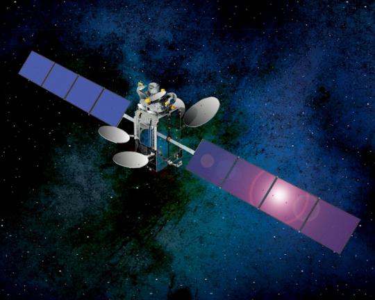
Artist’s rendering of the SES-5. Photo: CANSPACE Listserv
News courtesy of CANSPACE Listserv.
The SES-5 geostationary communications satellite (also known as Sirius 5 and Astra 4B) was launched from the Baikonur Cosmodrome on July 9 at precisely 18:38:29.994 UTC. After a number of manoeuvres by the various rocket stages, the satellite was released from the Breeze-M upper stage into its geostationary transfer orbit (GTO) at 03:50:15.150 UTC on July 10.
The planned GTO has a perigee height of 4,170 km, an apogee height of 35,786 km, and an orbital inclination of 23.1 degrees. The satellite’s apogee-kick motor should place the satellite into its geostationary Earth orbit (GEO) within the next few days. The GEO sub-satellite point will be at 5 degrees east longitude.
SES-5 hosts a dual-frequency transponder for the European Geostationary Navigation Overlay Service (EGNOS). The pseudorandom noise codes to be used by the satellite are not yet known.
“SES-5 is an important addition to our fleet serving both our commercial and government customer with our first L-band payload for EGNOS to augment the GPS system for Europe. This is a great accomplishment by all of the teams who worked on the SES-5 mission — SES, ILS, Khrunichev, and Space Systems/Loral — and we thank them for their dedicated work on the successful launch,” said SES President and CEO, Romain Bausch.
TomTom launches the first quarterly Congestion Index that accurately identifies and analyses traffic congestion in major cities across Europe. The report, initially covering 31 cities, finds Warsaw the most congested city in Europe.
On average, journey times in Warsaw are 42% longer than when traffic in the city is flowing freely and 89% longer during morning rush hour. The TomTom Congestion Index, including individual city reports, can be found at www.tomtom.com/congestionindex.
The TomTom Congestion Index is the world’s most accurate barometer of congestion in urban areas. The Index is uniquely based on real travel time data captured by vehicles driving the entire road network. TomTom’s traffic database contains over five trillion data measurements and is growing by five billion measurements every day. The overall congestion level for all the cities analysed in Europe is 24% – meaning journey times take 24% longer than when traffic is flowing freely.
The top ten most congested European cities, ranked by overall congestion level, between January and March 2012 were:
Warsaw, 42%
Marseille, 41%
Rome, 34%
Brussels, 34%
Paris, 32%
Dublin, 30%
Bradford – Leeds, 28%
London, 27%
Stockholm, 27%
Hamburg, 27%
“Over the years, with the help of our customers, we have built the largest and most accurate database of travel times in the world,” said Harold Goddijn; Chief Executive Officer of TomTom. “When we combine this travel database with our detailed real-time traffic information and routing technology, we can not only pin point congestion, but can guide drivers away from congested areas onto faster routes.”
“Even when only a percentage of drivers use a different and faster route, the available capacity on the entire road network increases, which benefits all drivers,” Goddijn added.
TomTom’s Congestion Index also compares congestion levels between January and March 2012 with the same period in 2011. Based on this analysis, Bradford – Leeds in the UK saw the biggest increase in traffic congestion with journey times slowing significantly. Munich, Berlin, Marseille and Vienna all saw increased levels of congestion. Lisbon, Bern, Amsterdam, Milan and Rome all experienced a reduction in congestion levels.
TomTom also launched the first quarterly Congestion Index that accurately identifies and analyzes traffic congestion in major cities across North America. The report, initially covering 26 major cities, finds Los Angeles to be the most congested city in North America. On average, journey times in Los Angeles take 33% longer than when traffic in the city is flowing freely and 77% longer during evening rush hour.
The Congestion Index compares travel time during non-congested periods (free flow) with travel times in peak hours. The difference is expressed as a percentage increase in travel time, representing the congestion level. The top ten most congested North American cities, ranked by overall congestion level, between January and March 2012 were:
Los Angeles, 33%
Vancouver, 30%
Miami, 26%
Seattle, 25%
Tampa, 25%
San Francisco, 25%
Washington, 24%
Houston, 23%
Toronto, 22%
Ottawa, 22%
TomTom’s Congestion Index also compares congestion levels between January and March 2012 with the same period in 2011. Based on this analysis, Seattle saw the biggest increase in traffic congestion, while Houston, Ottawa and San Francisco also saw increased levels of congestion. Conversely, Edmonton, New York, Boston, Minneapolis and Toronto experienced a reduction in congestion levels.
TerraGo Technologies Inc. has acquired the complementary software products and technologies of Manhattan Beach, CA-based Geosemble Technologies Inc. Terms between the privately held companies were not disclosed. Both firms are In-Q-Tel portfolio companies.
According to the announcement, Geosemble’s flagship product, GeoXray automates the process of discovering, geospatially visualizing, monitoring and sharing relevant unstructured information from any source. The software mines and processes content from news, blogs and social media and analyzes data by place, time and topic. GeoXray decreases the amount of time analysts spend sifting through big data and produces more germane information specific to an area of interest. The solution, which is used by a number of intelligence agencies, frees analysts to spend more time on quality analysis and enables better collaboration with peers, decision makers and field personnel.
TerraGo reports that the strategic acquisition of Geosemble builds on TerraGo’s growing geospatial intelligence applications and reports expertise. The combined companies’ solutions will now enable users to selectively discover relevant spatial content; compose dynamic, interactive geospatial intelligence applications and reports; and collaborate in online and disconnected environments. The new TerraGo suite of solutions will facilitate enhanced situational awareness and actionable intelligence for better planning, improved decision making and faster response.
Founded in December of 2004, TerraGo reported that Geosemble is a spin-off from the University of Southern California (USC). Its founders are computer science faculty members and originally developed the company’s core artificial intelligence and geospatial data analysis algorithms at USC. The technology has since been strengthened and refined to apply to a range of government and commercial user needs focused on automatically discovering and integrating information into satellite and aerial imagery and maps. The Geosemble business and technical team will be brought into TerraGo as the Geosemble solutions group, and the office in Manhattan Beach will be expanded to accommodate additional engineering staff as well as support resources to serve TerraGo’s growing West Coast customer base. Both firms are In-Q-Tel portfolio companies.
“The strategic acquisition of Geosemble will enable our customers to discover, visualize, monitor and share geospatial intelligence relevant to their operations and areas of interest,” said TerraGo Pres. and CEO Rick Cobb. “We warmly welcome our new colleagues to the TerraGo team, which, as always, remains committed to our tradition of product innovation and dedication to customer success.”
“This union is a perfect fit for Geosemble since TerraGo brings valuable distribution, implementation and customer support capability to Geosemble’s products, in addition to TerraGo’s own valuable suite of complementary technology. The combined resources of our companies will enable us to further develop advanced geospatial intelligence solutions for our existing defense and intelligence customers as well as others in crisis management, public safety and a wide range of commercial businesses,” said Andre Doumitt, former Geosemble CEO and now TerraGo vice president of business development for Geosemble solutions.
Esri announced that GeoIQ, a small geo-location company based in Arlington, Virginia, will be joining their organization. The addition of GeoIQ’s team will strengthen Esri’s capabilities in the areas of user experience design, web development and cloud-based applications.
"We are excited to join the Esri family, integrating our technology and extending the Esri platform,” says Sean Gorman, founder of GeoIQ. “Esri’s approach to ‘GIS for Everyone’ is transformational in the industry and is very closely aligned with GeoIQ’s vision, so we are extremely excited about working together.”
“We believe this will help us supplement our capabilities in delivering simple geospatial solutions for our customers around the world as well as the rapidly growing web developer and content delivery communities,” said Jack Dangermond, president, Esri.
According to the announcement, GeoIQ staff will join Esri at a new software development center located in Washington, D.C. and extend the ArcGIS platform with special emphasis on federal government clients in the areas of self-service mapping, analytics, big data, content streaming and social media. This center will also support web developers that are focusing on geo-enabling their web solutions with Esri’s geospatial platform. Existing GeoIQ users will continue to be supported.
GPS World magazine has opened the first State of the Industry Survey for completion by GNSS industry members; the interactive form is found at env-gpsworld-integration.kinsta.cloud/industrysurvey. The results of the Survey, compiled and analyzed, will appear in the September issue of the magazine, as the very first State of the Industry Report, accompanied by an economic study titled “GNSS and the Economy: Scenarios for the World and Some Implications for the Industry.”
Participation in the survey is open to all members of the GNSS community; however, it is necessarily focused on industry, not academia or government. Its core questions address business outlook, issues of business concern, revenue ranges, and GNSS products supplied, specified, or purchased.
The State of the Industry report in the September issue will draw from the survey to cover such topics as:
The global economy and how it affects business in each GNSS sector: Customers’ availability of capital to invest is top-of-mind for most industry professionals, whether designers, manufacturers, integrators, suppliers/dealers, or end users.
Industry confidence in the road ahead: is the prolonged recession over, or still ongoing? Are customers expanding aggressively or proceeding cautiously?
Investment for return: how are suppliers implementing their business outlook? What priority do they allocate to cutting expenses, maintaining current sources of revenue, increasing sales to core clients, developing new customers, R&D for new products or services, exploring mergers or acquisitions or IPOs — or something else?
Issues of concern: to what extent do industry leaders take into account pricing and competion; GNSS jamming, spoofing, other RF interference; compatibility or interoperability issues among GNSSs; funding for satellite system development or modernization; funding for application development; Manufacturer readiness for coming new GNSS constellations; and compatibility/interoperability issues with open-architecture non-GNSS positioning systems.
The State of the Industry Report will receive wide distribution, to the full subscription base of both print and digital magazine, and bonus distribution at ION-GNSS in Nashville, Tennessee (September), InterGeo in Hanover, Germany (October), and other outlets.
Prize Drawing.Incentives for participation in the survey include entry into a drawing for an iPad3, a pair of tickets to GPS World’s Leadership Dinner in Nashville during ION-GNSS, a surprise offering, and coffee-shop gift cards. A majority of the questions must be answered to qualify for the prize drawing. As the survey is business-focused, some non-industry community members in academia or government may find that they cannot answer many of the questions. Their participation is still encouraged, even if they do not qualify for the drawing.
Navilock, a trademark of Tragant Handels- und Beteiligungs GmbH, announces a new family of GLONASS receiver products including the NL-662U USB-based receiver, equipped with a u-blox GLONASS chipset.
Since the end of 2011 the Russian satellite navigation system GLONASS has been available worldwide. Similar in functionality to the US-NAVSTAR GPS system, GLONASS satellites transmit positioning data over distinct frequencies (Frequency Division Multiple Access, or FDMA, versus GPS which uses Code Division Multiple Access, or CDMA).
The new GLONASS receiver products have internal patch antenna in various configurations to serve different installation requirements. Four housing variants with USB or serial MD6/TTL interfaces are available for installation on vehicles or boats.
The u-blox GLONASS chipset features high accuracy to support precision location-based applications such as navigation, datalogging or tracking.
The products provide -158-dBm signal sensitivity with extremely low power consumption to insure reliable performance and long battery life. The u-blox GLONASS chipset facilitates hot starts in less than 3 seconds.
For more information, visit Navilock’s website and click on “new products.”
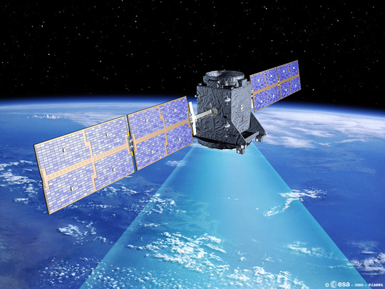
Artist’s impression of GIOVE-A in orbit. (ESA, P. Carril)
With the initial satellites of the Galileo constellation working well in orbit, it has been decided to end the mission of ESA’s pioneering GIOVE-A navigation satellite, reports the European Space Agency.
Launched on December 28, 2005, this first experimental satellite performed the vital task of securing the radio frequencies provisionally set aside for Galileo by the International Telecommunications Union.
It also flight-tested Galileo atomic clocks and other equipment in space for the very first time and investigated the radiation environment of medium-altitude orbits, never used before by a European mission.
ESA formally ended GIOVE-A’s mission at the end of June, although it will go on being operated for now by prime contractor Surrey Satellite Technology Ltd of Guildford, UK, to gather radiation data and performance results from a GPS receiver.
“GIOVE-A had a design life of only 27 months, so to continue operating for 78 months is impressive,” said Valter Alpe, managing GIOVE activities for ESA.
“In August 2009, the satellite was moved into a graveyard orbit around 100 km above its normal 23,222 km to make way for the Galileo validation satellites.
“The first two of these were launched on 21 October 2011 and are performing well, so while GIOVE-A has served ESA well it no longer has a job to do.”
Built to a tight deadline by SSTL, GIOVE-A carries a rubidium atomic clock accurate to three seconds in a million years.
On 27 April 2008 it was joined by GIOVE-B, built by an Astrium-led consortium, which carries an even more accurate passive hydrogen maser clock — the first to be flown in space for navigation, accurate to one second in three million years — as well as a second rubidium clock. Operational Galileo satellites carry two pairs of both kinds of clock, for redundancy. They are very different missions in other ways too. The GIOVEs were modified from existing satellite platforms: a prototype geostationary minisatellite for GIOVE-A, and a commercial French Proteus platform typically used for Earth observation for GIOVE-B.
Galileo satellites are based on an entirely new platform and improved payload, specifically engineered for extremely high reliability, only intended to go into safe mode for a few days over their planned 12 years of operation thanks to a robust design based on reconfigurable redundancy.
Even when entering ‘intermediate safe mode’ they can continue to supply navigation signals, although without the usual service guarantee. GIOVE-B, with an orbital lifetime of 50 months and counting, will be used in payload fine calibration tests this summer with the two Galileo satellites.
Then, in September, it will be manuvered into a graveyard orbit 300 km higher. At this point, GIOVE-B’s own mission will end.
“Early October will see the launch of the next two Galileo satellites by Soyuz rocket from Europe’s Spaceport in French Guiana,” added Valter.
“This will be an important step forward because four satellites are the minimum to perform navigation measurements, so Galileo system testing can proceed.” A follow-up batch of full operational capability Galileo satellites is being built by Germany’s OHB and SSTL, with initial Galileo services forecast to be available by 2014.
Roscosmos is conducting further tests on the launch vehicle for the SES-5 satellite, and have postponed the launch for two days. The new launch date is Monday, July 9, with an approximate launch time of 18:24 UTC.
The launch of SES-5 from the Baikonur Cosmodrome, originally scheduled for June 18, was first rescheduled to July 7 due to a problem with a first stage subsystem on the Proton launch vehicle.
SES-5 is also known as Sirius 5 stemming from the development of the Sirius satellite constellation by Nordic Satellite AB, now ownded by Luxembourg's SES. The satellite carries a transponder for the European Geostationary Navigation Overlay Service (EGNOS). The transponder is intended to eventually replace or supplement one of those on the currently used EGNOS satellites (Inmarsat 3-F2 at 15.5 degrees west using PRN 120, Inmarsat-4-F2 at 25 degrees east using PRN 126, and Artemis at 21.5 degrees east using PRN124, and designated for industry tests).
Unlike the present L1-only EGNOS satellites, SES-5 will have transponders on both the L1 and E5 frequencies similar to the setup on the Wide Area Augmentation System satellites, which broadcast on L1 and L5.
SES-5 is to be stationed at 5 degrees east longtiude. A second SES satellite with EGNOS transponders is under construction. The SES Astra 5B satellite is scheduled for launch in the second quarter of 2013 and will be positioned at SES Astra's 31.5 degrees east orbital position.
The Russian SBAS satellite, Luch-5A, has been repositioned so that its sub-satellite longitude is 95 degrees east. The satellite had been drifting from its original geostationary position at 58.5 degrees east longitude since about May 30.
The orbital slot of 95 degrees east had been previously announced for Luch-5B, so perhaps Luch-5A is switching positions with Luch-5B, which is scheduled for launch on August 30, although a recent Roscosmos presentation indicates the launch might not happen until October.
Luch-5A is the first of a set of three geostationary satellites being launched to reactivate Roscosmos’s Luch Multifunctional Space Relay System. The system will be used to relay communications and telemetry between low-Earth-orbiting spacecraft, such as the the Russian segment of International Space Station, and Russian ground facilities.
The satellites also carry transponders for the System for Differential Correction and Monitoring (SDCM), Russia’s satellite-based augmentation system. The transponders will broadcast GNSS corrections on the standard GPS L1 frequency using C/A PRN codes assigned by DoD’s Global Positioning Systems Directorate. Luch-5A was assigned PRN 125; Luch-5B, PRN 140; and Luch-5V (previously called Luch-4), PRN 141.