NASA has awarded PlanetiQ an expanded contract through its Commercial Smallsat Data Acquisition (CSDA) program, broadening access to commercial satellite data for the scientific community.
The contract expands PlanetiQ’s CSDA portfolio to add high-SNR GNSS polarimetric radio-occultation data to PlanetiQ’s existing NASA CSDA offerings of ionospheric scintillation, ionospheric total electron content, and high-SNR GNSS radio-occultation data.
The expanded data offering will provide government researchers with access to advanced GNSS observations that can help improve the understanding of precipitation processes, atmospheric structure, and Earth system dynamics.
Polarized radio occultation (PRO) measurements have demonstrated the ability to characterize precipitation, detect rain and snowfall structure, identify melting layers, and observe variations in storm intensity. PlanetiQ uses a unique receiver to collect data with a high signal-to-noise ratio (SNR). High-SNR measurements are particularly important for precipitation applications because increased SNR improves sensitivity to lighter precipitation and certain cloud structures.
“By making polarized radio occultation data available through the CSDA program, NASA is enabling a broader research community to investigate new applications for these observations,” said E. Robert Kursinski, chief scientist, PlanetiQ. “As more researchers gain access to high-SNR PRO data, we expect both the scientific understanding and the potential operational uses of the technology for precipitation and severe weather monitoring to expand.”
PlanetiQ’s GNSS-PRO measurements are acquired using high-rate, high-SNR receivers that enhance the detection of precipitation signatures and cloud structures. In addition to supporting atmospheric science research, these measurements are critical for operational applications related to rainfall characterization, snowfall detection, storm monitoring, and weather forecasting.
Researchers interested in learning more about GNSS-PRO and precipitation sensing can watch PlanetiQ’s recent webinar.
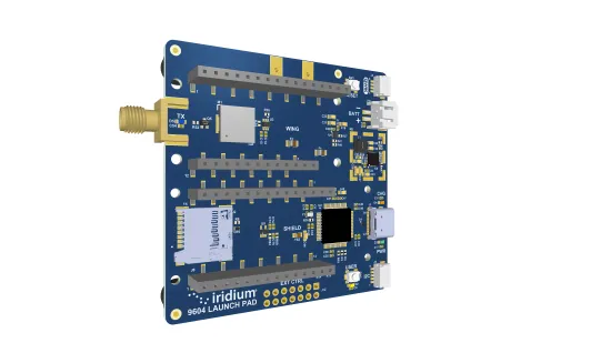
The Iridium 9604 module and development kit streamline global IoT development with integrated satellite, cellular and GNSS connectivity
Iridium Communications has announced commercial availability of the Iridium 9604 module and Development Kit, giving developers, OEMs and solution providers a faster path to build and scale connected IoT solutions worldwide.
Combining GNSS positioning, Iridium short burst data satellite connectivity, and LTE-M cellular, the Iridium 9604 module delivers a compact, integrated solution for global IoT deployments.
The Iridium 9604 Development Kit, back side. (Credit: Iridium)
Alongside the Iridium 9604 Development Kit, developers can rapidly prototype, test and validate hybrid satellite, cellular, and GNSS applications with resources that simplify integration and streamline deployment workflows.
Built on the u-blox SARA-R5 platform, the Iridium 9604 is designed to reduce hardware complexity, lower integration costs, and accelerate time to market for connected solutions operating across industrial, infrastructure, transportation, mobility, utilities, maritime and remote-monitoring applications. The integrated design helps reduce board space requirements by 60 percent or more while simplifying RF routing, power architecture, and firmware development, Iridium said.
Early developers and beta participants reported significant operational and economic benefits from the platform’s integrated architecture.
“The Iridium 9604 has enabled us to develop a truly global asset tracking solution without relying on terrestrial network infrastructure. Its reliable coverage, compact form factor, and straightforward integration have significantly accelerated our development process and allowed us to focus on optimizing the end-user experience,” said Askar Gabit, CEO, GPSOne. “For applications in remote and challenging environments, the Iridium network provides the confidence that critical data can be delivered when it matters most.”
The Iridium 9604 gives developers independent control over satellite, LTE-M and GNSS subsystems, enabling flexible implementation of failover logic, location-aware connectivity decisions, and application-specific routing strategies. A unified AT command set and comprehensive SDK resources further simplify development and integration.
Built for scalable and power-sensitive IoT applications, the Iridium 9604 features a compact 16 x 26 x 2.4 mm form factor optimized for deployments where size, resiliency and efficiency are critical. The platform supports GPS, GLONASS, Galileo and BeiDou GNSS services alongside LTE-M (Cat-M1) and Iridium’s 100% global L-band satellite network.
The Iridium 9604 represents the next evolution of Iridium’s broader IoT strategy, expanding beyond traditional satellite-only hardware to support unified, multi-mode connectivity architectures. The Iridium network now supports multiple IoT pathways, including dedicated Iridium SBD modules, Iridium NTN Direct standards-based direct-to-device capabilities, and larger payload connectivity through the Iridium Certus 9704 module.
Operating on a global mobile satellite network, the Iridium 9604 delivers reliable connectivity across remote land areas, oceans, airways and polar regions where other networks are unavailable or unreliable.
The QLX3Gx chip makes secure, authenticated positioning a standard feature
Qualinx has integrated support for the Galileo OSNMA (Open Service Navigation Message Authentication) on its QLX3Gx Series ultra-low-power GNSS receiver.
Developed with the support of the European Union Agency for the Space Programme (EUSPA), the integration makes the QLX3Gx a GNSS receiver purpose-built for ultra-low-power markets to deliver hardware-native OSNMA support as a standard feature across the entire product family.
Qualinx has embedded OSNMA support directly into the QLX3Gx hardware architecture from the ground up, enabling a fully optimized design with zero trade-offs in power consumption, cost or performance.
“Authenticated positioning has for too long been out of reach for the devices that need it most,” said Qualinx CEO Tom Trill. “By building OSNMA support into the QLX3Gx at the hardware level from day one, we’re making trusted positioning the default — not a premium option — for the wearables, asset trackers and IoT devices that make up the bulk of the GNSS market.”
The partnership with EUSPA reflects a shared commitment to disseminating Galileo’s advanced security capabilities across the widest possible range of applications and markets. EUSPA identifies OSNMA as a strategic priority for improving resilience against spoofing and signal manipulation
According to the EU Space Market Report 2026, global GNSS revenues are projected to grow from €300 billion in 2024 to €580 billion by 2034 with mass-market devices accounting for the largest share of shipments and representing the greatest growth potential.
Through Qualinx’s digital radio-frequency technology, the QLX3Gx delivers up to 10× lower power consumption than conventional GNSS solutions. By integrating OSNMA natively in hardware, the chip eliminates the processing overhead typically associated with authentication, ensuring security adds no meaningful cost to the power budget.
The chip’s reconfigurable digital RF architecture enables capabilities to be updated over time without hardware replacement — extending device lifecycles, cutting electronic waste, and lowering overall energy consumption. The result is a platform that makes connected devices more secure and sustainable.
The QLX3Gx chip is available for sampling, with mass production planned for the second half of this year. Developers and OEMs can register interest in the Qualinx QLX3Gx Evaluation Kit to secure hands-on evaluation of the QLX3Gx for upcoming consumer, industrial and mobility applications. Contact [email protected] to register interest and request a sample, or learn more at Qualinx.io.
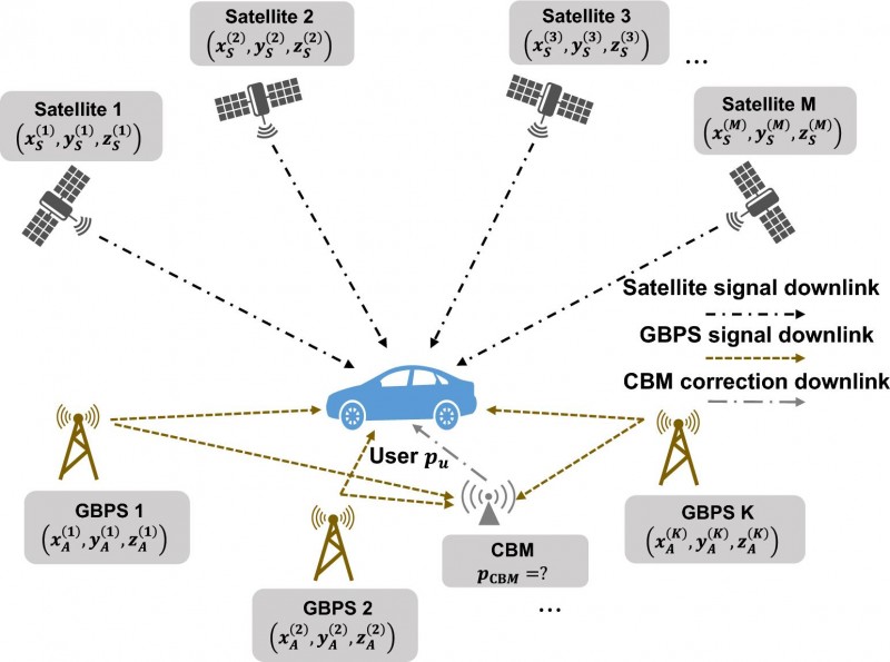
Asynchronous GBPS can improves both convergence speed and positioning reliability
Precise point positioning (PPP), a high-accuracy GNSS technique, offers the advantage of centimeter-level positioning without relying on local reference stations. However, PPP often requires many minutes to achieve full precision, making it less suitable for dynamic environments.
Previous efforts have shown that ground-based positioning systems (GBPS) can accelerate convergence by providing additional geometric constraints. Yet most GBPS solutions depend on highly accurate time synchronization among base stations, which increases infrastructure costs and limits deployment flexibility.
Asynchronous GBPS (A-GBPS) remove this synchronization burden, but their potential for augmenting PPP has remained largely unexplored. Deeper investigation into practical PPP augmentation with A-GBPS is needed.
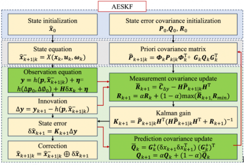
Researchers from the Department of Electronic Engineering at Tsinghua University report a new GNSS augmentation framework in a study published (DOI: 10.1186/s43020-026-00200-4) in the journal Satellite Navigation. The researchers developed a tightly coupled positioning architecture that integrates GNSS with A-GBPS. By combining satellite and A-GBPS observations, the framework significantly accelerates positioning convergence and improves solution stability, offering a practical pathway toward more efficient high-precision navigation services.
Rather than requiring all base stations to share the same clock, the new framework embraces their asynchronous nature. The researchers developed a method that uses a dedicated monitoring station to correct transmitter clock biases before integrating the measurements with GNSS observations. This allows the system to exploit the strong signal power and favorable geometry of ground-based transmitters without the operational burden of network-wide synchronization.
The team first established a theoretical model showing that adding A-GBPS observations should reduce positioning uncertainty. Numerical simulations then demonstrated that adding A-GBPS can significantly strengthen geometric constraints, particularly in the directions where satellite-only positioning is weak. The benefits became even more pronounced after the positioning solution stabilized, suggesting that A-GBPS can complement GNSS throughout the positioning process.
Field test results
To test the approach under real-world conditions, the researchers deployed six A-GBPS base stations and conducted field experiments using a mobile receiver platform. Compared with GNSS-only positioning, the augmented system reached higher accuracy with faster convergence and delivered more stable positioning performance.
The experiments also revealed an important engineering insight: adding more base stations generally improved performance, but the gains began to level off beyond about five or six stations. This finding may help future network designers balance positioning performance against deployment costs.
The authors said the work demonstrates that high-precision PPP augmentation does not necessarily require tightly synchronized GBPS. Instead, asynchronous GBPS can provide valuable geometric information that improves both convergence speed and positioning reliability.
Using existing 5G networks
They said the results indicate that existing terrestrial communication facilities, like 5G, could potentially support future positioning services. Such an approach may offer a practical pathway toward more accessible high-precision navigation without high deployment expense and complexity, which usually associated with synchronized GBPS.
The implications extend beyond navigation research. Faster and more reliable positioning could benefit autonomous driving systems, unmanned aerial vehicles, intelligent transportation networks, surveying operations, and mobile mapping platforms that depend on rapid access to precise location information. Because the framework is compatible with existing radio infrastructure, it may lower barriers to deployment and expand positioning coverage in challenging environments.
The researchers note that future work will focus on eliminating the need for a dedicated monitoring station and evaluating performance under more complex urban conditions, where signal blockage and multipath interference are more prominent.
GNSS CORS network to be established on university grounds
Global GIS (Pvt) Ltd, a pioneer in geospatial positioning solutions in Sri Lanka, has entered a Memorandum of Understanding with the University of Ruhuna to collaborate with the Department of Civil and Environmental Engineering and the Department of Electrical and Information Engineering of the Faculty of Engineering.
Areas identified for collaboration include conducting research and development activities, developing and commercializing new inventions and solutions, industry projects and consulting opportunities, and disseminating scientific knowledge to meet the growing demand of surveying and geospatial technologies and to increase efficiency and sustainability in the nation’s engineering industries and its thematic requirements.
“We are honored to enter this mutually beneficial collaboration with the University of Ruhuna to enhance capacity and support the growing geospatial and surveying industry in Sri Lanka,” said Nishshanka De Silva, sureyor and CEO-managing director of Global GIS. “We aim to take the industry in Sri Lanka to the next level with new innovative products and solutions while building sufficient capacity to undertake the country’s next phase of growth. Geospatial and surveying technology plays a significant role in sustainable infrastructure planning, renewable energy, disaster management, optimizing natural resource allocation, and many other areas as Sri Lanka pursues its national development goals.”
Under the MOU, Global GIS will establish a high-precision GNSS Continuously Operating Reference Station (CORS) network station at the university to enhance the university’s capacity for advanced GNSS-based research and applications to promote GNSS technology among government, semigovernment, and private organizations.
Global GIS will also open a funding avenue to
support research and development activities for the duration of the agreement,
provide necessary commercialization experience and business knowledge for new inventions and solutions,
conduct training and internship opportunities for the undergraduates on surveying and geospatial technologies to foster skill development and practical experience, and
leverage its “Authorized Agent” status for the brands it promotes in Sri Lanka to enhance the University of Ruhuna’s capacity in the latest surveying and geospatial technologies.
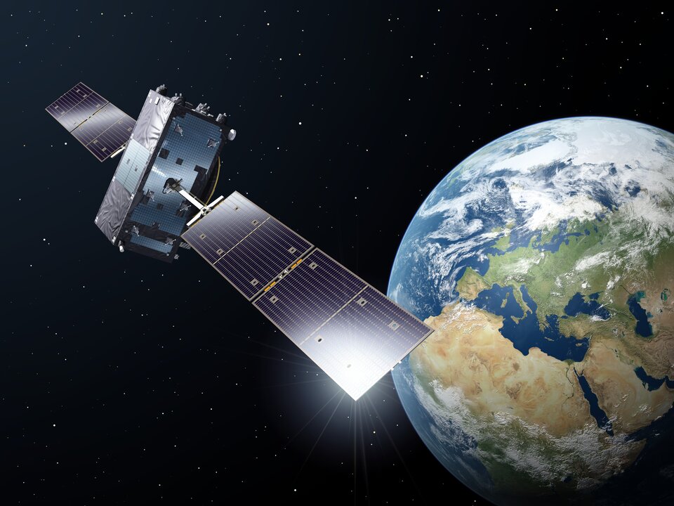
In April, Galileo marked a step forward with the deployment of a new signal component, known as E5a Quasi Pilot, on 12 satellites of Europe’s satellite navigation constellation. This upgrade makes Galileo signals easier to access, particularly on emerging mass-market, low-power devices used for Internet of Things and smart city applications.
With the world’s most precise satellite navigation system, a constellation of more than 30 satellites and five billion of users worldwide, Europe’s Galileo continues to strengthen its position at the forefront of global navigation satellite systems (GNSS).
Galileo signals, like other GNSS signals, traditionally consists of two components: pilot signals and data signals. The first ones are data-less and help enable the receiver to acquire and track the signal, while the second carry all the navigation information needed to pinpoint the target’s location.
But what if this traditional concept could be rethought to respond to emerging market needs, particularly for users seeking faster and simpler acquisition?
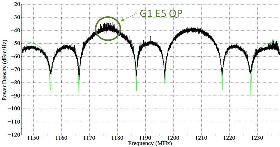
The European Space Agency and its industrial partners have developed a solution targeted at mass-market applications that require low power: E5a-QP, a Quasi-Pilot (QP) signal component transmitted in Galileo’s E5 band.
The signal component is broadcast free of charge and now available for implementation in both new and upgraded chipsets, enabling all users of the Galileo Open Service to benefit from its capabilities.
A small addition for a big computational deduction
Quasi-Pilot means a pilot signal that retains its intended role but also carries a small amount of data, including the time information necessary for a first fix. This time information is fully predictable at user level. A Quasi-Pilot signal component is also characterised by a tailored signal structure that simplifies the acquisition process, which reduces the power consumption on the receiver’s end.
This proves particularly useful for low-power, basic receivers such as those found in smartphones, smart-city infrastructure, internet-of-things devices and those that only need to receive a GNSS signal for a very small time to determine their position (also known as ‘snapshot’ devices).
The deployment of E5a-QP also represents a key enabler for low-power receivers designed to process signals exclusively in the E5 band, rather than relying on signals in the E1 band. In this way, the resilience of the receiver against spoofing and jamming attacks is increased, as the fundamental acquisition process is no longer only dependent solely on E1 signals.
Test campaigns have demonstrated that E5a-QP can reduce signal acquisition time by a factor of three, while substantially lowering the number of operations required for acquisition by a factor of eight.
The introduction of this new Galileo signal component follows an extensive series of design, testing and validation that demonstrated the value of the signal and the feasibility of implementing new signal components on current Galileo satellites.
Starting 2020, a design phase explored how to reconfigure the Galileo satellites’ payload to integrate the new signal component. Following on, a series of tests were run on engineering models at ESA’s Navigation Payload Laboratory to demonstrate the feasibility and performance benefits that can be achieved with the new signal component.
In 2023, the solution was then validated using an in-orbit test bench: a duo of Galileo satellites operating in an elliptical orbit reconfigured to transmit the new signal component. The signal was measured at Galileo In-Orbit Test facility at ESEC in Belgium and DLR’s Signal Monitoring Facility in Germany, and successfully acquired and tracked by a set of receivers at ESTEC in the Netherlands.
First generation updated, second generation in mind
Between November 2025 and April 2026, twelve Galileo satellites were updated to accommodate this new signal component, marking the completion of this deployment.
This critical mass of satellites ensures that at least one of the satellites used to compute a position fix transmit the Quasi-Pilot signal at medium to high elevation angles, making sure that users around the world can benefit from the performance gains.
Honeywell has launched Kestrel, a compact navigation solution designed to help uncrewed aerial systems (UAS) operate reliably in contested environments where GPS signals may be degraded, jammed or spoofed.
Built to support the growing demand for smaller, more affordable and highly efficient platforms, Kestrel combines Honeywell Aerospace’s HG3900 MEMS inertial measurement unit with an M-code receiver and a multi-GNSS receiver. The platform is intended to meet the specific needs of Group 2 and 3 collaborative combat aircraft and loitering munitions platforms. It is also suitable for crewed aircraft where size, weight, power and cost are important considerations.
“Kestrel reflects the evolving needs of today’s uncrewed operations, where operators are looking for resilient navigation technology that is smaller, lighter and more cost-effective,” said Matt Picchetti, vice president and general manager of Navigation & Sensors at Honeywell Aerospace. “This system helps operators maintain mission objectives in environments where legacy GPS systems are lagging behind.”
Kestrel is an Embedded GNSS/INS (EGI) system for global defense and commercial operators in need of advanced inertial navigation technology with secure positioning capabilities in a smaller footprint. The system is 40 percent smaller and lighter than similar navigation products while delivering up to an 80 percent improvement in navigation accuracy for uncrewed platforms. It also reduces costs by as much as 50 percent, helping operators efficiently scale deployment across high-volume drone operations. Kestrel’s resiliency reduces UAS attrition by 60 percent, while more than doubling the capacity for mission distances.
The ability to operate without assured GNSS access is a distinct advantage for any military aircraft operating in contested or GNSS-denied environments because it provides continuous, self-contained position, velocity and attitude estimates independent of external signals.
Kestrel is designed to support a broad range of defense and commercial applications and will be available in configurations that support international and non-ITAR deployments.
Honeywell pioneered EGI technology and has produced more than 60,000 units since the mid-1990s to meet customers’ most challenging navigation, pointing, stabilization and flight-control applications.
New algorithm cuts indoor positioning error by nearly half
Conventional indoor positioning often depends on expensive Wi-Fi or Bluetooth infrastructure, or on inertial sensors that accumulate drift within seconds. Magnetic navigation has emerged as a promising alternative because steel structures and electronics leave buildings with unique, location-specific magnetic signatures.
However, existing map-free methods rely on polynomial models that oversimplify the magnetic field’s spatial variations. They capture the broad trend but miss the sharp, local anomalies caused by metal pipes or distribution boxes.
With these limitations, a more accurate, robust, and physically interpretable approach to magnetic field modeling is urgently needed for practical indoor navigation.
A team from the Aerospace Information Research Institute, Chinese Academy of Sciences, publishing (DOI: 10.1186/s43020-026-00201-3) in the journal Satellite Navigation on June 5, has unveiled a robust magnetic-inertial odometry (MIO) method based on the Fibonacci sphere-sampled equivalent magnetic dipole model, denoted as FSS-EMD-MIO. The system uses an array of 30 small magnetometers and an inertial measurement unit to track movement without any external signals.
The core innovation lies in how the system models the indoor magnetic environment. Instead of drawing smooth curves through the data, it represents the local field as a combination of virtual “equivalent magnetic dipoles” — with 16 dipoles identified as optimal through systematic parameter analysis.
Their positions are determined by the Fibonacci sphere sampling technique, which evenly distributes points in 3D space without any directional bias, preventing overfitting. Each dipole’s magnetic moment is then solved in real time using least squares fitting.
The team also derived the spatial gradient of this model, creating a direct mathematical link between changing magnetic readings and the carrier’s displacement, velocity, and attitude. To handle the inherent nonlinearity and location-dependent noise, an adaptive error state Kalman filter fuses inertial data with magnetic observations. Tested on a public dataset, the method achieved a horizontal positioning root mean square error below 1.27 meters, outperforming the previous state of the art (MAINS) by 46% on average.
“The old polynomial methods look at the magnetic field from far away — they see the hills but not the potholes. Our model places virtual sources exactly where the magnetic perturbations live,” the authors explained. “The Fibonacci sphere sampling ensures that no direction is favored, so whether you tilt the sensor or walk in circles, the system adapts reliably. We essentially gave the building’s chaotic magnetic field a readable 3D structure. This means first responders or warehouse robots can finally have a ‘magnetic compass’ that works even when the lights are off and GNSS is out.”
The research paves the way for truly infrastructure-free indoor navigation. Potential applications include guiding firefighters through smoke-filled buildings, tracking inventory robots in steel-racked warehouses, and providing positioning for autonomous vehicles in parking garages or mines. The authors note that future work will incorporate loop-closure detection to correct long-term drift, akin to how a person recognizes a familiar intersection.
By developing scan-matching algorithms based on overlapping magnetic field regions, the team aims to build a complete magnetic simultaneous localization and mapping (SLAM) system for multi-floor buildings, further closing the gap between outdoor and indoor navigation reliability.
The forum brings together experts from industry and regulatory authorities to discuss the future of network and spectrum monitoring in increasingly complex RF environments.
The forum will provide a full day of insights, technical exchange, and hands-on demonstrations. Rohde & Schwarz and its partners will present keynote addresses and expert presentations, and provide networking opportunities with professionals from across the network and spectrum monitoring ecosystem. Participants also can consult directly with Rohde & Schwarz technology specialists.
The U.S. Space Force has awarded Lockheed Martin a $514 million contract to build GPS IIIF Space Vehicles 23 and 24, bringing its total GPS IIIF commitment to 14 spacecraft.
With legacy spacecraft past their intended design life, the award marks a vital step in continued modernization of the constellation. The 14 upcoming GPS IIIF satellites will deliver advanced, reliable positioning, navigation and timing (PNT) capabilities for both military and civilian users.
IIIF capabilities include:
The Regional Military Protection capability that provides a 63-fold increase in anti-jam capabilities, allowing warfighters to access strong GPS signals in contested environments
Additional M-code-enabled satellites, allowing for secure GPS connection for warfighters
A digital navigation payload, increasing accuracy and reliability of IIIF spacecraft.
“Modernizing the constellation with highly resilient, next-generation space vehicles ensures warfighters have access to the GPS capabilities they require for their missions,” said Christina Mancinelli, vice president of global communications and navigation at Lockheed Martin. “We continue to invest in advanced technology, facilities and the people who are the driving force in the production of this spacecraft that help our military secure peace.”
Earlier this year, all Lockheed Martin-made GPS III satellites reached orbit. GPS III SV09 and SV10 each launched on accelerated timelines, bringing unprecedented levels of resiliency to the constellation.
The GPS constellation provides critical positioning, navigation and timing capabilities to key warfighter platforms made by Lockheed Martin. For example, the F‑35 uses GPS to determine its exact location, keep its systems perfectly synchronized, and share real‑time position data with other assets, enabling autonomous navigation and pinpoint strike capabilities.
Similarly, the UH-60 Black Hawk employs GPS to navigate accurately, deconflict with ground and air forces, and deliver cargo or weapons with high precision, enhancing mission safety and effectiveness.
For civilians, the GPS constellation underpins banking transactions, telecommunications networks, emergency‑response services, and everyday navigation. The new GPS IIIF satellites broadcast all civil signals — including the interoperable L1C and L5 — at greater accuracy and reliability.
Advanced design features speed and resiliency
GPS IIIF satellites are engineered for resiliency. Starting with SV13, these spacecraft are built on the evolved LM2100 Combat Bus, providing increased cyber-hardening, improved spacecraft power, propulsion and electronics. The LM2100 Combat Bus is also outfitted with additional size, weight and power to accommodate future capability insertions.
The company has already completed the core mate milestone — marking the official “birth” of a satellite — for three GPS IIIF satellites, with all other IIIF satellites in different phases of production. The company was also recently awarded a $105 million contract to continue modernization of the GPS ground segment. With these contracts, Lockheed Martin reaffirms its long-term commitment to a resilient, high-performance GPS constellation that supports billions of users worldwide.
Lockheed Martin continues to advance GPS IIIF production at its Denver area facilities, employing emerging technologies such as augmented reality and digital twins to accelerate build rates and ensure capabilities are delivered to the warfighter quickly.
At the defense and security show Eurosatory 2026 in Paris, Hensoldt is presenting SkyBarrier, a mobile jammer for satellite-based navigation signals.
The system is designed as an electronic countermeasure. It is aimed at armed forces and government agencies that need to protect critical infrastructure and personnel from the use of enemy navigation-based systems.
The SkyBarrier is capable of simultaneously jamming all GNSS signals. The jamming effect extends to both civilian and military variants of these systems, as well as encrypted signal variants. The system thus covers the entire range of currently relevant frequency and coding variants.
A key feature of the system is its mobility and operational speed. Two people can set up SkyBarrier, including mast assembly and cabling, and have it ready for operation within a few minutes. Activation then takes place via a mechanical switch on the front panel in a matter of seconds — no software-based configuration is required. The complete system consists of a single portable electronic unit, an extendable telescopic mast and the associated accessories.
The system is designed for future expansion: new signal types can be retrofitted by replacing individual components without having to replace the entire system. In terms of security and cybersecurity, the SkyBarrier offers a high level of protection; the electronics have only three physical interfaces, which do not allow any external data communication.
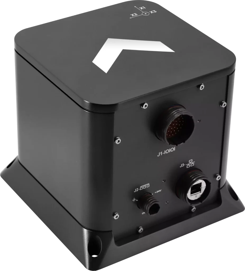
Exail has unveiled the Advans Vega SL, a new high-precision inertial navigation system that maintains navigation continuity across amphibious operations.
In contested littoral environments, maintaining reliable navigation across the sea-to-land transition remains a persistent challenge for amphibious forces. In the event of GNSS jamming, spoofing or signal unavailability, the Advans Vega SL operates independently of any external signal from vessel departure to shore, ensuring forces maintain continuous positioning and fire control readiness without reconfiguration at any stage.
The Advans Vega SL INS. (Credit: Exail)
As a single, self-contained solution covering both maritime and land phases, it also removes the integration constraints associated with multi-system architectures, which typically require reconfiguration or handover at the water-to-land transition.
With 0.05° RMS heading accuracy in the maritime phase and 0.5 mils RMS on land, the Advans Vega SL system maintains positioning continuity in GNSS-denied environments without reconfiguration.
“GNSS signal denial is now an operational assumption in any amphibious and littoral combat planning,” said Yann Le Balc’h, business development manager for land defense, Exail. “The Advans Vega SL removes satellite dependency at the most exposed phase of an amphibious operation, giving forces the autonomy to project ashore on their own terms.”
Drawing on Exail’s fiber-optic gyroscope technology, the Advans Vega SL delivers 0.05° RMS heading accuracy in the maritime phase and 0.5 mils RMS on land — the highest navigation precision achieved to date in a system designed for the full sea-to-land transition. This performance level is rooted in decades of navigation expertise across land and naval operations, now brought to bear on a capability requirement that has become increasingly critical in modern amphibious warfare.
With navigation systems in service with more than 70 navies and land forces worldwide, Exail is a recognized supplier for defense forces requiring sovereign, signal-independent positioning capability across all operational domains.