RapidFlight has been awarded a $10 million contract from the United States Department of the Air Force (DAF) under the AFWERX Autonomy Prime program. Under the contract, RapidFlight will develop and produce the SPX, a customizable, autonomous fixed-wing aircraft system.
The project objective is to design and produce the SPX UAV, featuring a 12 lb. payload capacity, 150 nm range, and a modular payload bay. The RapidFlight Common Avionics 2.0 will be used to support autonomous flight with various payloads.
During the initial phase of the 36-month contract, RapidFlight will design SPX UAVs for testing at the Autonomy Prime Proving Ground. This will be followed by a contractor-owned, contractor-operated (COCO) demonstration at the RapidFlight facility in Manassas, Virginia. Comprehensive training for USAF operators is also included.
Each SPX system includes four airframes, a ground control station, a field kit and a compact launcher. The system’s modular design supports a range of payloads, sensors and autonomy packages for rapid and economical real-world flight testing.
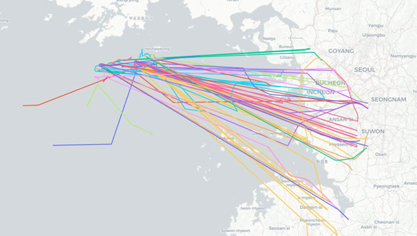
Aircraft operating near Seoul, South Korea spoofed to points in the ocean 28 to 30 May 2024. (Image: SkAI Data Services)
On the morning of May 30, 2024, Benoit Figuet posted on X that 40 aircraft operating into and out of South Korea had been spoofed over the previous 18 hours.
Professor Jiwon Seo at South Korea’s Yonsei University reports that the interference has, as of June 3, entered its fifth consecutive day.
Benoit Figuet is the co-founder of SkAI Data Services in Zurich, Switzerland. In collaboration with the Zurich University of Applied Sciences, SkAI created the world’s first public Live GPS Spoofing Tracker website. The site uses ADS-B data to detect and display in near-real time, aircraft being spoofed around the world.
South Korean military authorities have identified North Korea as the source of interference.
While the spoofing exhibits many of the same traits as interference in the Black Sea and elsewhere, Figuet has noted some differences. “We even see aircraft impacted at low altitudes,” he said. “We have observed this happening below 5,000 feet and even affecting an aircraft taxiing on the ground at the airport. The source must be at a reasonably high elevation or fairly close by.”
North Korea has a history of engaging in hybrid, non-kinetic warfare by interfering with GPS in the South, though this is the first large-scale event since one lasting from March 31 through April 5, 2016.
During the 2016 event, five different locations along the border of South Korea were identified as sources of interference. One is at an elevation of approximately 740 m and only 30 km from Inchon International Airport.
Another unique feature of the ongoing interference, according to Figuet, is the dynamic nature of the spoofed location. Unlike previously observed “circle spoofing,” the reported locations generally appear as tracing a figure eight pattern in the ocean near a point where the territorial seas of both countries meet.
Some of the spoofed locations have also been observed drifting over the North Korean border.
Local media have reported that the interference seems to be in conjunction with maritime maneuvers being conducted by the South Korean Navy and police vessels. The North has complained about intrusions into its territorial sea during these operations, a claim disputed by South Korea.
To help counter the effects of the North’s interference, South Korea has added to and upgraded its eLoran system. It has also included the eLoran upgrade in a comprehensive resilient PNT architecture that includes television signals and plans for a regional positioning, navigation and timing (PNT) satellite system.
According to Pyo-Woong Son, Ph.D., “South Korea is set to enhance its navigation and service reliability with the fully operational and established eLoran system. This system is expected to ensure that ships can navigate safely even during large-scale GPS signal disruptions, like those the country has recently experienced.” Son is a Senior Researcher at the Korea Research Institute of Ships and Ocean Engineering.
“In addition to maritime applications, eLoran will significantly contribute to the reliable operation of autonomous vehicles, such as urban air mobility (UAM), which are rapidly gaining popularity as future modes of transportation.”
“Furthermore, eLoran will play a crucial role in enhancing the reliability of public and private sector services, including broadcasting, telecommunications, and finance, where precise timing synchronization is essential,” according to Son.
Loran-C was used in many aircraft for decades before the advent of GPS. While eLoran signals are available across most of the Far East, receivers are not included in the navigation suites of commercial aircraft.
Aircraft operating into and out of Incheon International Airport have, so far, been able to use local terrestrial aviation-specific navigation aids to safely approach, land and depart.
Mr. Dana A. Goward is President of the Resilient Navigation and Timing Foundation and is a frequent contributor to GPS World.
VIAVI Solutions has launched its altGNSS geosynchronous orbit (GEO) SecureTime services designed to deliver nanoseconds-accurate UTC timing through L-Band and Ku-Band satellite signals. It is ideal for critical infrastructure including 5G networks, transportation, data centers, smart grid, high-frequency trading, military and first responder communications and satellite terminals.
The company said that operating independently of traditional GNSS, VIAVI’s altGNSS GEO service is difficult to jam or spoof and offers broad global coverage, further improving resistance to attacks.
SecureTime adds to the portfolio of solutions VIVAI offers for resilient PNT, and features navigation message authentication (NMA), which uses encryption to detect spoofing in any of the signals received from all sources — including GPS that does not support NMA. It builds on VIAVI’s existing multisource assurance, combining signals from government and commercial constellations across GEO, low-Earth orbit (LEO) and medium-Earth orbit (MEO).
These services have been tested and proven in live-sky battlefield scenarios, providing assured PNT in a simulated warzone with complete denial of GNSS signals.
VIAVI will integrate these services into its products and offer receivers for third-party solution providers to integrate into their systems. VIAVI’s SecurePNT 6200 hardware platform is powered by space and terrestrial SecureTime Services and TrustedPNT multisource fusion technology.
VIAVI is showcasing these solutions at the Assured PNT Summit on May 29-30 in Washington, D.C. and the Joint Navigation Conference (JNC) held June 3-6 in Cincinnati, Ohio.
Commander, Naval Surface Force, U.S. Pacific Fleet Vice Adm. Brendan McLane is rung in upon his arrival to the establishment ceremony for Unmanned Surface Vessel Squadron 3 (USVRON 3) on Naval Amphibious Base Coronado May 17, 2024. The squadron is comprised of unmanned Global Autonomous Reconnaissance Crafts (GARCs). The 16-foot GARCs built by Maritime Applied Physics Corporation enable research, testing, and operations that will allow integration throughout the surface, expeditionary, and joint maritime forces. (Photo: U.S. Navy photo by Mass Communication Specialist 1st Class Claire M. DuBois)
The U.S. Navy has created Unmanned Surface Vessel Squadron (USVRON) Three at Naval Amphibious Base Coronado. The squadron, equipped with Global Autonomous Reconnaissance Crafts (GARCs), aims to enhance the Navy’s capabilities by integrating unmanned systems into surface and joint maritime operations.
GARCs, developed by the Maritime Applied Physics Corporation, facilitate research, testing and operations for seamless integration across surface, expeditionary and joint maritime forces. These crafts will be used for various missions, including operations with carrier strike groups and surface action groups. Additionally, the squadron will introduce a new robotics warfare specialist rating to oversee and operate these systems.
The mission of USVRON Three is to provide the most powerful unmanned platforms in the maritime domain. The squadron will play a key role in establishing the knowledge needed to operate and maintain sUSV. It will develop tactics, techniques and procedures for small unmanned surface vessel (sUSV) operations and sustainment. USVRON Three’s motto is “Victory Through Ferocity.”
Photo: Space Surveillance Operations Center (COVE)
The Spanish Ministry of Defense has awarded a $2.9 million contract to GMV, for the development, deployment support and maintenance of the Space Situational Awareness and Control System (CCSE). The system will be used at the Spanish military Space Surveillance Operations Center (COVE).
Under the contract, GMV will conduct orbit calculation and propagation, build-up and maintenance of a space object catalog (both open and classified), prediction of atmospheric reentry, calculation of overflight events, planning of observation and sensor calibration campaigns, calculation of GNSS signal degradation and integration and processing of space weather data.
This system is expected to go into service at the end of 2024. To comply with this timeline, it will be based on GMV’s Ecosstm system, which is being used in other operational environments such as the German Armed Forces’ Space Domain Awareness Center (Weltraumlagezentrum), the civilian space surveillance systems of various other countries such as Greece and GMV’s commercial space surveillance center known as Focusoc.
The COVE, which is operated by the Ministry of Defense (MINISDEF) through its Space Command (MESPA) of the Spanish Air and Space Force (EA), was created in November 2019. The center reached its initial operational capability (IOC) in 2021.
GMV has been supporting the center and assisting its participation in the Global Sentinel exercises organized by the U.S. Space Command. As part of its support, GMV has supplied its operational orbit determination tool, Sstod, for processing data from the Spanish space surveillance radar located at the Morón Air Base, near Seville, Spain.
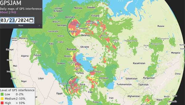
Figure 1: GPSJAM map on March 23, 2024. The map is based on GPS accuracy reports fron aircraft broadcast digital radio messages (ADS-B) over a 24-h period. A vast (uncolored) area on the globe is not covered because of no ADS-B report. Arcs are drawn over part of Europe and the eastern Mediterranean to help visualize the cone of the interference coming from potential jamming power sources. (Photo: GPSJAM.org)
GPS services are critical for real-time information on positioning, navigation and time (PNT). Because of the highly accurate and continuous PNT solution provided by GPS in all weather conditions, this multi-use technology has been adopted for civil applications including some for transportation, agriculture, aviation and emergency services. The increasing societal dependence on GPS has also created a set of security vulnerabilities for these applications.
GPS applications are vulnerable to signal interference, spoofing and degraded or denied services. Both intentional — jamming — and unintentional signal interference can cause inaccurate PNT and poor navigation performance. In addition, GPS service may be intentionally degraded or disrupted during military operations and system testing. Environments in which the GPS service is unavailable or severely degraded require alternative solutions for PNT.
Several countermeasures have been implemented to mitigate the vulnerabilities of GPS receiving systems including flex power operation and signal encryption/authorization initiated by the service provider and signal filters and adaptive antennas implemented by a user. For example, a new military signal, M-code, from GPS III satellites has an improved anti-jamming capability in both the L1 and L2 frequency bands. GPS III can broadcast signals using a high-gain directional antenna, in addition to a wide-angle, full Earth antenna, which produces a restricted area spot service by manipulating signal strength. Such flex power operations help improve GPS performance in the presence of jamming. The flex power operation is different from the so-called Selective Availability (SA), which was an intentional degradation of civilian GPS signal accuracy globally. SA operation was discontinued in May 2000, so GPS services are always available for civil applications worldwide.
However, the transparency and openness of GPS services for peaceful uses is facing a hard reality, as the balance between peacetime and wartime applications can quickly change due to geopolitical conflicts. Attacking and overcoming GPS vulnerabilities has become a fast-evolving battlefield in modern electronic warfare. Jamming and spoofing of GPS — and other GNSS — have increased substantially in the eastern Mediterranean, Baltic Sea, and Arctic regions since Russia’s invasion of Ukraine. This was officially documented by the European Union Aviation Safety Agency in Safety Information Bulletin 2022-02R1 issued in November 2023.
For example, on March 23 to 24, 2024, widespread GPS jamming occurred in Eastern Europe that impacted more than 1,600 aircraft over a period of two days and was widely reported by mass media. The source of this massive jamming event was thought to be in Russia’s Kaliningrad exclave between Lithuania and Poland. As shown in FIGURE 1, the panoramic cone in the jammed region appears to support this speculation. Similar events with large-scale jamming occurred on December 25 to 26, 2023; January 19, February 2, 12 and 14; and March 1 to 3, 13, 15 to 16 and 18, 2024, according to GPSJAM.org. In addition, Figure 1 reveals a wide area of jamming in the eastern Mediterranean where the Israel-Hamas and Israel-Hezbollah conflicts are taking place.
The increased level of GPS jamming has had a significant impact on global science observations over the conflict regions, including low-quality measurements for soil moisture, and atmospheric and ionospheric soundings, as reported in the March issue of GPS World. In addition, NASA has observed many more dropouts from in-orbit GPS receivers in recent years, which degraded the ephemeris information used for scientific data. As the pattern of apparent GPS jamming continues, alternative filtering of the spaceflight GPS data would be required to safeguard continuous science operations.
The study reported in this article aims to provide a global perspective on recent GPS jamming and degraded services. Since late 2019, commercial CubeSat constellations such as Spire have provided atmospheric measurements with much-needed global coverage and spatiotemporal sampling. The amount of GNSS data increased from about 7,000 observations per day in 2020 to about 20,000 per day in 2022 thanks to the observation demand from weather and climate research.
Table 1: Spire satellite groups and GPS satellites observed.
SPIRE CUBESAT CONSTELLATION
Spire Global has flown more than 100 Low Earth Multi-Use Receiver (LEMUR) CubeSats since 2014. These cost-effective CubeSats are used to track maritime, aviation and weather activity from space, and can be replenished at a relatively fast pace for a low-Earth orbit (LEO) constellation. TABLE 1 lists the Spire CubeSats used in this study, showing their orbital inclination, flight model ID and the tracked GPS pseudorandom noise (PRN) code ID. Spire receivers track GPS L1C/A and L2 signals for precise orbit determination (POD) and radio occultation (RO) measurements with 1-Hz and 50-Hz sampling respectively. These Spire POD and RO data collections — from November 2019 to the present — are part of a contract under NASA’s Commercial Smallsat Data Acquisition Program.
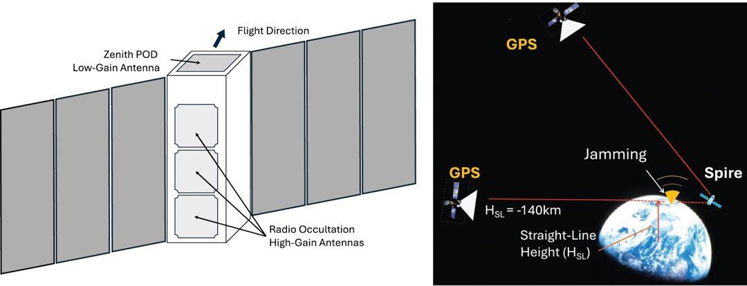
Figure 2: A schematic of the Spire 3-unit (10 x 10 x 34 cm) LEMUR CubeSat showing a zenith-view POD (precise orbit determination) and a limb-view RO (radio occultation) antenna for GPS measurements. There are usually two RO antennas on the fore-and-aft line with respect to the flight velocity, but only one POD antenna is mounted at the top. (Photo: Dong L. Wu)
The Spire LEMUR spacecraft have gone through several generations and expanded capabilities from atmospheric sounding with GPS radio occultation (GPS-RO) to GPS reflectometry (GPS-R) for soil moisture and ocean winds, grazing-angle reflectometry (GPS-GR) for sea ice and GPS-POD ionospheric sounding for space weather. In essence, however, as illustrated in FIGURE 2, these measurements are made available from two types of antennas on the satellites: a low-gain POD antenna and a high-gain RO antenna. As the measurement capability and performance improved, these antenna designs have become increasingly sophisticated and may differ substantially from satellite to satellite. Thus, it is imperative to characterize these antenna patterns carefully before comparing their signal amplitude or signal-to-noise ratio (SNR).
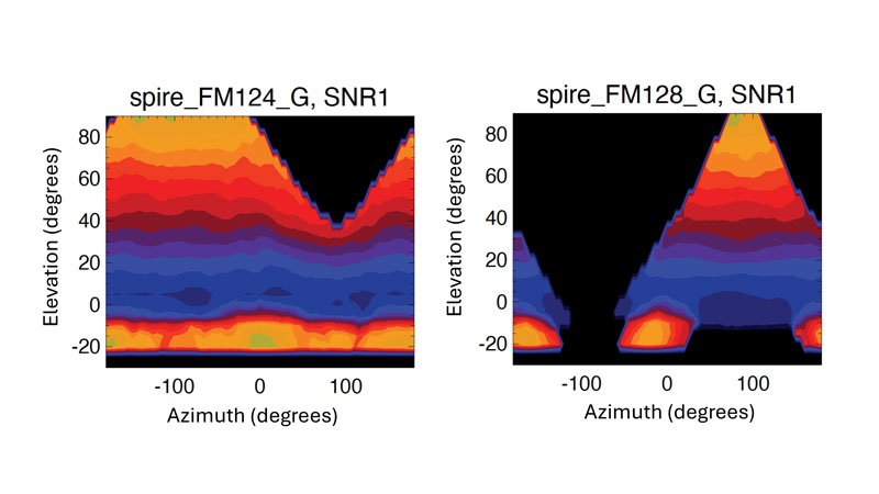
Figure 3: POD antenna patterns derived empirically from Spire FM124 and FM128 data as a function of elevation and azimuth angles. The elevation angle is defined as the angle of GPS line-of-sight (LOS) above the spacecraft horizon. The azimuth angle is defined as the difference between GPS LOS and spacecraft velocity azimuth angles with respect to the north. A 5° x 5° bin size was used in the averaging. Colors are the mean L1 SNR in arbitrary unit from two-month data aggregation. The antenna patterns of L1 and L2 signals are assumed to be same.
Instead of using ground calibration data, we employed an empirical method using the flight data to derive Spire’s POD antenna patterns. For each CubeSat, we aggregated a few months of POD data according to the GPS-POD link direction, in terms of elevation angle and azimuth angle with respect to the satellite flight direction. The averaging of such a large ensemble of measurements allows us to smooth out the fluctuations due to ionospheric scintillations and GPS service power variations. Two examples illustrated in FIGURE 3 show drastically different antenna patterns and designs between Spire FM124 and FM128. The larger antenna gain values at high positive elevation angles are expected for the commercial off-the-shelf (COTS) planar POD antenna pointing at zenith, whereas the gain at the bottom of negative elevation angle range is an added feature in this antenna design to enable a limb sounding of ionospheric electron density. To monitor the GPS service power, we use only the SNR measurements at positive elevation angles greater than 30° using the antenna pattern normalized by the mean values in this angular range.
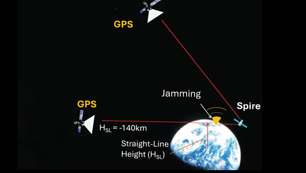
We analyzed both Spire POD and RO SNR data. The POD SNR data are used to determine the GPS service power, while the RO SNR data are used to estimate the jamming power or jammer-to-noise ratio (JNR) from the surface. The POD SNR data at high elevation angles are mostly from free space but need to be corrected for the antenna pattern effect to measure the GPS signal strength accurately. Depending on the GPS-POD link direction, the antenna pattern can cause a large variation in the observed SNR (see Figure 3). For JNR detection, we use the RO SNR data from very low elevation angles (lower than 0°) with a straight-line height (HSL) of less than -140 kilometers. At this height, a tracked GPS satellite is completely obscured by Earth and the RO receiver is essentially measuring the receiver system’s noise. Thus, any enhanced “noise” would be considered as a jamming signal. The RO antenna pattern is less critical in this case because the locations of ground jamming sources are unknown and their signals are weak at spacecraft altitudes. Roughly speaking, the RO antennas tend to acquire signals within a horizontal field of view (FOV) of 60°, corresponding roughly to a swath of about 1,800 kilometers at the surface. Therefore, the RO JNR has a coarse spatial resolution and represents a collective emission from the ground sources.
DEGRADED SERVICE AND JAMMING
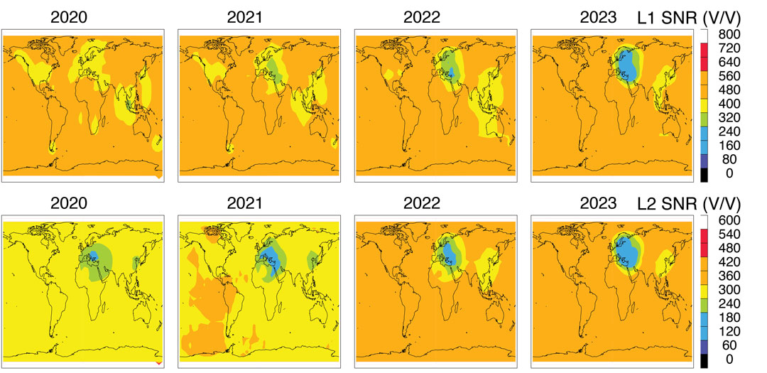
To monitor GPS service power, we normalized the Spire POD SNR with the empirically calculated antenna pattern for each CubeSat. The normalized SNR data are averaged to produce a global monthly map and then annual maps (see FIGURE 4). The L1 and L2 SNRs from Spire represent an average GPS power at an orbital altitude of about 530 kilometers. The normalized SNRs are geo-registered using the CubeSat location where the measurement was made.
Variations between different GPS satellites as well as between different Spire CubeSat altitudes are neglected in this study. Broadcasting powers from the GPS satellites may differ by a small (about 10%) amount between PRNs, which manifest themselves as a slightly inhomogeneous distribution in the maps (see Figure 4). The impacts of the Spire orbital altitude on the estimated GPS power are small, compared to the regional GPS power reduction seen over Europe.
Further improvements can be made to produce a more accurate estimate of the GPS power as well as a time series of power changes from individual PRNs.
There is a clear GPS power reduction in the L1 and L2 signals over several targeted regions. The reduction appears to differ between L1 and L2 bands during the 2020 to 2023 interval. The most prominent power reduction regions are Europe and the Middle East, where the L2 reduction started as early as 2020. Although the L1 reduction is present in this region, it deepened after 2021 and perhaps widened more in 2022 and 2023. The degraded services for a targeted region are consistent with the new capability of GPS III in operation.
Figure 4: Annual mean GPS L1 (top panel) and L2 (bottom panel) SNR distributions observed by Spire POD receivers for 2020-2023. (Photo: Dong L. Wu)
A relatively small GPS power reduction can be found in East China and Southeast Asia in the 2020 to 2023 period. The L1 power reduction in this region reveals a shift from Southeast Asia in 2019 to East China in 2023, whereas the L2 reduction appears to be concentrated in East China during these years. While geopolitical tensions in this region did not escalate to any wars, electronic warfare operations have been widely reported over the South China Sea, the East China Sea, and the Philippines since 2017.
Jamming detection from space is a more challenging task because of the generally weak JNR at the height of orbiting receivers. In addition, a wide antenna FOV of GPS receivers could yield less accurate geolocation of jamming sources. However, jamming detection has been made from several LEO satellites by various teams of scientists and engineers. By tracking the front-end noise of an RO receiver on the MetOp satellite, researchers were able to detect the elevated noise power originating from ground-based sources. Also, using the radio frequency spectra recorded with a nadir-viewing receiver on the International Space Station, investigators demonstrated the feasibility of detecting jamming and spoofing signals from the ground. It has been shown that the location of jamming/spoofing sources can be pinned down accurately with observations from two satellites. This technique laid the foundation for a new class of space intelligence missions such as the DEEP prototype, STRATOS and HawkEye-360. Studying the SNR perturbations in POD data from GRACE and COSMIC-1/2, it was possible to generate global maps of jamming hotspots from 2007 to 2016. Investigators have made use of the enhanced noise in delay Doppler maps of down-looking GPS-R receivers for jamming detection. Recently, we analyzed GPS-RO SNR measurements at the tangent heights obscured by Earth and reported the increased level of jamming in northern Africa, the Middle East and the eastern Mediterranean after 2018.
Compared to nadir-view techniques, jamming detection from limb views has some advantages and disadvantages. Disadvantages have been associated with the long path length between the source and the receiver, resulting in a potentially weak JNR and poor geolocation of jamming sources. On the other hand, if jammers chose to radiate the power horizontally for a wide areal impact, it would allow limb-view sensors to pick up the jamming power and identify the directionality of jamming sources by comparing the JNR observed from opposite look angles.
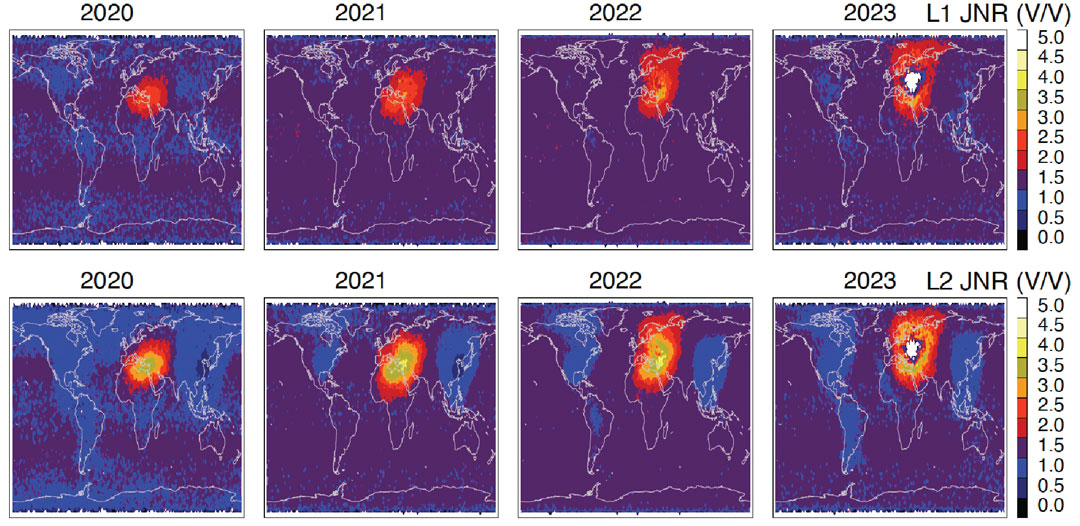
FIGURE 5 As in Fig. 4 but the L1 and L2 JNR are derived from the Spire RO SNR measurements at HSL < -140 km. A 3 V/V background noise is subtracted from the SNR measurements to obtain the JNR. In 2023 the white region inside the enhanced jamming is caused by the quality control (QC) of Spire data processing that excluded the RO data with a low free-space SNR. (Photo: Dong L. Wu)
Without any sophisticated data processing, in the study for this article, we simply averaged all the RO L1 SNR data at HSL less than 140 kilometers to extract the JNR power by subtracting a 3 V/V (volts per volt) noise from the average (see FIGURE 5). This approach is slightly different from our previous study, which normalized the JNR by the free-space SNR. Because the JNR signals were so strong in 2020 to 2023, no normalization is needed to enhance the jamming detection.
It is not surprising to see in Figure 5 that the worst GPS-jammed region appears in the Middle East and the surrounding area where geopolitical conflicts have broken out frequently in recent years. In the Syria and Libya civil wars, as well as in the Russia-Ukraine and Israel-Hamas conflicts, low-cost UAVs (commonly referred to as drones) and precision-guided munitions were widely used in attacks, which was a major incentive to deploy electronic warfare to jam GPS-guided weapons and operations.
As shown in Figure 5, the JNR power was mostly concentrated in the eastern Mediterranean, the Middle East and northern Africa in 2020 and 2021 but spread to northern Europe after Russia invaded Ukraine in 2022. More JNR power appears to be in the GPS L2 band compared to L1, likely because L2 is a weaker signal and easier to jam and degrade GPS performance in navigation applications.
The regions of GPS signal reduction and enhanced jamming are highly correlated in the Spire observations. The high correlation is expected for the increased use of militarized commercial drones and GPS-guided munitions in the conflict zones. In the Russia-Ukraine war, low-cost GPS-based commercial drones have been imported to the battlefield, as have jamming capabilities. Their modifications and tactical use are evolving rapidly as the conflict continues. A precursor of such massive use of low-cost drones was in the Libya civil war (2014 – 2020), in which thousands of airstrikes were reported. Most of these commercial-grade drones relied on GPS civilian signals for navigation. Therefore, denying or reducing the GPS civilian signal power can help degrade the performance of militarized commercial drones. On the other hand, jamming and spoofing GPS signals remains a cost-effective electronic warfare technique in these conflicts.
CONCLUSIONS
This article has provided an overview of global GPS jamming and service reduction between 2020 and 2023 using recent observations from the Spire constellation. The service power reduction and jamming power increases are highly correlated on a regional scale, showing that Europe and the Middle East have been most impacted by the ongoing geopolitical conflicts. The area of the impacted regions has widened significantly from 2021 to 2023 and spread to Northern Europe. The dual-use civil and military GPS technology and services are currently experiencing an unprecedented scale of electronic warfare attacks.
ACKNOWLEDGMENT
The work reported in this article was supported by NASA’s Commercial Smallsat Data Acquisition program.
Some of us will remember that was how Sgt. Phil Esterhaus ended the morning roll call on the classic TV show “Hill Street Blues.” Although this warning was directed at police officers in carrying out their sometimes dangerous duties, it is good advice to anyone relying on GPS or any of the global navigation satellite systems (GNSS). Why? Although GPS and the other systems work very well in many environments, there are situations where the surroundings, such as those in natural and urban canyons, can block and reflect signals degrading or even denying positioning and navigation capabilities. And that’s not all. Space weather can also occasionally affect GPS and the other systems, limiting their use.
On top of such environmental concerns, we must worry about accidental and intentional disruptions of GNSS by radio frequency interference (RFI). GNSS signals received on or near Earth’s surface are fairly weak — much weaker than, say, cell phone signals — and so can be easily overpowered by nearby stronger radio signals. This is commonly referred to as jamming and there have been many instances of deliberate interference with GPS signal reception in North America and elsewhere. In fact, although its use by civilians is illegal, GPS jamming equipment is available that can stop a GPS-based tracking system from working.
On the other hand, GNSS signal jamming has become a common military tactic and its use is now widespread across the globe. While users might be aware that their navigation equipment is not working due to jamming, there is also the more insidious technique of spoofing, in which false GPS-like signals attempt to trick a receiver into using them rather than the true signals, resulting in an erroneous position report perhaps hundreds of kilometers away from the receiver’s true position.
While the use of GNSS jamming and spoofing can be detected on the ground and by aircraft overflying locations where the activity is taking place, these signals can be more comprehensively studied from space using satellites carrying receivers with appropriate spectrum coverage. In this quarter’s “Innovation” column, a researcher with NASA’s Goddard Space Flight Center reports on studies of GPS signal interference he has conducted using observations from a constellation of low-Earth orbiting (LEO) satellites that use onboard GNSS receivers to provide data for use in operational meteorology and the study of space weather and climate. However, the receivers also intercept jamming and spoofing signals as the satellites pass over conflict zones multiple times per day. It is in these zones and surrounding areas that all users relying on GNSS must be extra careful out there.
The UK has successfully tested quantum-based navigation systems in flight. The commercial trial was led by Infleqtion, a quantum technology company, and is designed to improve resilience against GPS jamming and spoofing.
Although GPS jamming typically does not affect an aircraft’s flight path, quantum-based positioning, navigation and timing (PNT) systems aim to provide accurate and resilient navigation, complementing existing satellite systems and offering uninterrupted operations for global air traffic.
Infleqtion, in collaboration with aerospace companies BAE Systems and QinetiQ, conducted the trials at MoD Boscombe Down in Wiltshire. Science Minister Andrew Griffith participated in the final test flight on May 9. The project has received nearly £8 million in government funding as part of the National Quantum Strategy, which seeks to establish the UK as a leader in quantum technology.
The test flights included two key quantum technologies: the compact Tiqker optical atomic clock and an ultra-cold-atom-based quantum system, both tested aboard QinetiQ’s RJ100 Airborne Technology Demonstrator. These technologies are part of developing a quantum inertial navigation system (Q-INS), which aims to provide precise and resilient navigation independent of traditional GNSS.
The successful flight trials are a step towards deploying quantum navigation systems on aircraft by 2030 as part of the UK’s National Quantum Strategy. The demonstrated potential of quantum technology in enhancing navigation security is an important development for future aerospace applications.
SpacePNT, a Swiss positioning, navigation and timing (PNT) solution provider for the new space satellite market, has completed in-orbit validation tests of its NaviLEO spaceborne GNSS receiver platform. The platform is designed to deliver decimeter-level positioning and nanosecond-level timing accuracy in low-Earth orbit (LEO) and signal reception sensitivity for GTO/GEO/moon missions. Using its unique and proprietary hardware and software technology, it can operate in real time.
After its successful deployment in LEO onboard its hosting orbital transfer vehicle, the D-Orbit ION OTV SCV-011 satellite, on June 13, 2023, Space PNT conducted a series of experiments to validate the key functionalities of the radiation-tolerant technology. This is done by demonstrating multiple modes of operation, including dual-antenna and full-in-flight reprogramming using FPGA image and application software.
Flight models have already been delivered to commercial and institutional partners for these missions, said SpacePNT co-founder and CEO, Cyril Botteron.
The upcoming second-generation hardware platform reuses the same key radiation-tolerant electronics components, designed for telecom constellations. It also implements new functions to serve additional markets such as software-defined radio platforms for telecom and radar applications.
The new space satellite market refers to companies such as SpacePNT, SpaceX and Blue Origin that are developing reusable rockets to drastically reduce the cost of access to space. The growth of satellite technology and new business models, such as satellite-based internet services, have created new opportunities for private companies.
The ongoing conflict between Hamas and Israel, along with the unrest in various universities across the United States in support of Gaza Palestinians, and the continued aggression by the Houthi rebels in Yemen against shipping, are impacting several aspects of our lives, including the rising cost of gasoline.
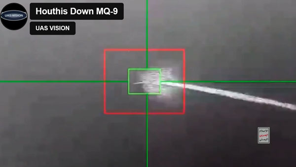
Since the United States began seeking out Houthi strongholds, it is now being reported that another MQ-9 Reaper drone has been shot down – making an apparent total of five such expensive U.S. UAVs lost over and around Yemen, according to US military reports.
Screenshot of a Houthi-released video of the downing of the MQ-9 Reaper drone (Photo: UAS Vision)
At $30 million each, compared to about $2 million for a surface-to-air missile, the Houthis are apparently ahead on cost. With a 50,000 ft ceiling, the Reaper is capable of avoiding short-range surface-to-air missiles. However, more visual or infra-red (IR) low-level detail may have been sought on this mission. In response, the U.S. military reported the downing of five Houthi UAVs over the Red Sea.
According to a Defense Intelligence Agency (DIA) report, Iran is supplying the Houthis with attack UAVs and longer-range missiles, which are often, if not always, re-assembled, repainted and re-named locally. The DIA said that one of the favorite Kamikaze UAVs used is the Iranian Shahed-136/Houthi Waid-2, which is reported to have a range of almost 1,600 miles. Neither side has yet acknowledged which drones were brought down by the United States.
However, around the same time, it was reported that perhaps two Houthi missiles hit the MV Andromeda Star oil tanker with reportedly little damage — no casualties were reported on the ship as it continued towards its destination Vadinar, India. Another ship, the MV Maisha, avoided a third missile. The missile landed nearby in the water, but the vessel put some distance between itself and the MV Andromeda, continuing safely.
The US/UK forces operating in the Red Sea have countered the more than 100 Houthi attacks on shipping with several airborne strikes on Houthi facilities. This renewed Houthi action over the weekend is thought to have been possible because they were restocked with weapons following the US/UK airstrikes, which slowed their attacks on shipping.
Hence the renewed threat to oil tanker traffic in the Red Sea has raised the already high threat level, and increased oil and gas prices at the pump are one of the consequences.
Meanwhile, Pakistan has bought 10 additional Chinese Caihong-4, which reportedly look and perform very similarly to the MQ-9 Reaper.
Caihong-4 looks very similar to the General Atomics MQ-9 Reaper (Photo: OE Data Integration Network (ODIN))
The CH-4 can be used for both attack and reconnaissance. It features a flight endurance of 30 to 40 hours, a range of 2,200 to 3,100 miles and can carry up to six weapons.
This brings Pakistan’s complement to 20 CH-4 UAVs. The new purchase may be to offset India’s purchase of 31 General Atomics MQ-9s, which is included in a huge, recently approved $3.99 billion weapons purchase from the United States. The two countries continue to feud over the contested Kashmir region.
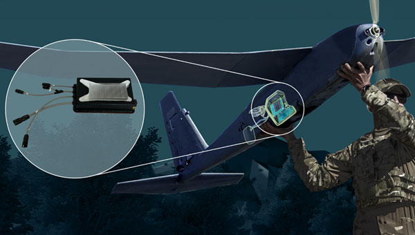
AeroVironment (AV) has developed an add-on for fielded Puma class hand-launched reconnaissance UAVs, which brings autonomy and machine-learning to a worldwide, mostly military fleet of thousands of air vehicles. Referred to as the Autonomy Retrofit Kit (ARK), with AVACORE software, the new update allows operators to command and control one or more vehicles autonomously. This provides computer vision capabilities and enables connection to a distributed, mobile comms network to access data for several separated operating groups.
ARK retrofit kit for Puma 3AE and LE UAVs (Photo: AV)
According to AV, autonomous operating tasking is possible when communications are jammed and the UAV is then still able to execute its mission without manual input. Updated computer vision allows finding, classifying, positioning and daylight or nighttime tracking of objects such as people, vehicles, aircraft and ships. AVACORE includes several software interfaces for different autopilots, sensors and radios to provide integration flexibility.
A neat way to provide significantly enhanced capability for already fielded airborne vehicles when they have some downtime.
Finally, we have a short introduction to a new transport UAV being put together by a California company called MightyFly. The company is led by a woman who was highly instrumental in the success of the flight controls for the Zipline UAV, which is still blazing drone delivery trails overseas and now in North America — with more than one million deliveries. With advisory input from a retired FedEx exec, the team at MightyFly seems well on their way with both a Federal Aviation Administration (FAA) approved Part 135 application and a 20 mile ‘point-to-point’ flight corridor approval for test flights.
Cento gen 3 cargo drone (Photo: MightyFly)
The MF-100 prototype made its first flight and demonstration delivery in April 2021, while the third-generation Cento flew for the first time in December 2022. Cento has a 6’ x 1’ x 1’ cargo hold that can accommodate 96 small USPS packages, weighing up to 100lb and Cento and later models are expected to have a range of 600 miles at up to 150 mph. While their UAVs are currently all-electric, the plan is to add a gas/rotary engine to charge batteries to achieve this forecast range for the drone.
MightyFly has significant support from the U.S. Air Force Agility Prime program and the Air Mobility Command, who continue to invest in autonomous cargo developments as an alternative to leasing helicopters to transport parts, medical supplies and more. MightyFly came up with an auto-loading capability, which resolves the issue of a potentially changing weight and balance of a last-mile cargo drone.
MerlinTPS has partnered with Bluespec to address the need for GNSS augmentation and backup technology as satellites continue to face new challenges, including wartime contested space as well as increased costs to produce and maintain satellites.
Under the partnership, MerlinTPS will develop its platform to support the expansion of PNT security capabilities by using existing signals of opportunity on the ground designed to combat jamming and spoofing.
“With our verification and validation-centric RISC-V solutions, MerlinTPS can develop customized solutions in a matter of weeks, allowing it to deliver highly differentiated products with minimal project and schedule risk,” said Charlie Hauck, CEO of Bluespec.
By implementing Bluespec’s RISC-V processors in Field Programmable Gate Arrays (FPGAs), MerlinTPS can quickly modify, generate and load new code onto FPGAs. This allows for hardware reuse, avoiding the need to build custom hardware for each task.
However, MerlinTPS can easily make customizations to Bluespec’s RISC-V soft processor cores — adding custom instructions designed to accelerate specific workloads — when needed. MerlinTPS plans to add artificial intelligence (AI) capabilities to the platform.
Jamming and spoofing continue to be the key challenges to military use of GNSS. While the production and adoption of M-Code receivers is delayed, defense contractors are developing several approaches to identify, locate and neutralize these threats — including CRPA antennas, embedded GPS inertial (EGI) navigators, software-defined radios and cryptography.
In this month’s cover story, executives from seven companies present their perspectives on the GNSS/PNT challenges faced by U.S. and allied military forces, their market niche in this area, and their latest products.
Lou Pelosi, vice president, CAST Navigation
Stig Pedersen, executive vice president of aerospace and defense, Autonomy & Positioning division, Hexagon
Brandon Malatest, COO, Per Vices Corporation
Tony Full, director of business development, Navigation Systems, Safran Federal Systems
Paul Crampton, senior solutions architect, Spirent Federal Systems
Joel Korsakissok, president, Syntony
Click here to read an exclusive interview with Chuck Stoffer, director of business development and Eric Hughes, design engineer, UHU Technologies
Read the related “Innovation” article.
Photo: Petty Officer 1st Class Thomas Gooley
What are currently the top two or three challenges regarding GNSS/PNT for U.S. and allied military forces? How do you expect that to change in the next three to five years?
CAST Navigation
A top challenge is anti-jamming. GPS signals are low-power and fairly easy to jam. CAST has developed a simulator for testing controlled reception pattern antennas (CRPAs), which are anti-jam antennas. CAST simulators can test CRPAs with two to seven antenna elements.
Another top challenge is preventing our enemies from using GPS in a war zone. M-Code Modernized Navstar Security Algorithm (MNSA) has been designed to support denial of GPS signals to enemy forces. CAST has developed the ability to simulate M-Code MNSA. The company is working closely with the U.S. Space Force Space Systems Command’s GPS Directorate to develop a simulator that supports all their requirements.
Hexagon
Jamming is the key challenge. The secondary challenge is getting necessary protection into fielded systems so they can be used to the full extent of their service life. Over the next three to five years, while new products designed to safeguard PNT infrastructure will emerge, the process of getting these tools authorized and integrated will remain complex.
Per Vices Corporation
GNSS signals can be disrupted or manipulated by adversaries through jamming techniques, leading to potential navigational errors or loss of positioning capabilities. Advanced spoofing techniques also pose significant challenges to GNSS/PNT for U.S. and allied military forces, as they can deceive receivers into providing inaccurate positioning, navigation, and timing information. Both can be addressed with the integration of software-defined radios (SDR) for GNSS/PNT applications where we anticipate a strong push to further advance the different anti-jamming and anti-spoofing techniques in software using high-performance SDR platforms.
Safran Federal Systems
GNSS denial and spoofing. Both challenges are expected to become more pervasive over the coming years as adversarial technologies evolve and are distributed. In the current conflict, systems are driving to become either assured GNSS or built to operate independently of GNSS clock and position information.
Spirent Federal Systems
Adversarial near-peer threats to PNT integrity are developing at an increasingly rapid pace. Navigation warfare (NAVWAR) used to focus within the boundaries of localized geopolitical conflicts, but now space-based, system-wide threats loom large and will present new challenges in the coming years. As PNT continues to evolve, more complex mitigation technologies must be integrated into a layered PNT ecosystem with shortened development and testing phases to be fielded faster.
Syntony
It is not a secret that jamming and spoofing will be the biggest challenges in the coming years: Almost every week, if not every day, we read some news about jammed or spoofed GNSS receivers, either in Eastern Europe or elsewhere.
Technology exists to protect against both threats: authentication, cryptography and CRPA. However, you cannot deliver an M-Code or PRS receiver to every soldier and every vehicle, if for no other reason than the difficulty of broadcasting the keys. The solution will pass by an intermediate level of anti-jamming and anti-spoofing receivers, which do not need them, associated to moderate prices and lighter infrastructure so that everybody and every vehicle can be protected.
For industry, it will pass through the generalization of CRPA architecture for the receivers, even for non-encrypted signals, and even with lower efficiency levels (update rate, J/S, etc.) corresponding to low dynamic movement.
What is your company’s niche regarding military GNSS/PNT?
senior software engineer Neil O’Brien utilizing a CAST-8000 GNSS simulator to analyze CRPA trajectory data. (Photo: CAST Navigation)
CAST Navigation
We are known for correctly interfacing with the military’s embedded GPS inertial (EGI) navigators.
Hexagon
We have carved out a distinctive position in the military APNT sector. We provide receivers that give users access to the entire GNSS spectrum, fortified by our unique GNSS Resilience and Integrity Technology (GRIT). Hexagon also produces anti-jam antennas designed to safeguard GNSS receivers, offering our customers tested protection in hostile environments.
Per Vices Corporation
We design, develop, and build high performance software-defined radio platforms and associated firmware/software for use in GNSS/PNT systems. This includes the use of SDRs for simulating hostile RF environments to test existing equipment, providing anti-jamming and anti-spoofing solutions, implementing dynamic frequency hopping, and signal authentication and integrity verification.
Safran Federal Systems
We are uniquely positioned to fulfill solutions to GNSS denial and spoofing through our precision timing, assured GNSS (M-Code/SAASM) and inertial navigation technologies. Additionally, we have these technologies often combined in different form factors to serve platform needs. When planning for missions, we offer our customers a full suite of mission simulation capabilities expediting the fielding of technologies by assuring functionality in a lab environment.
Spirent Federal Systems
We find our niche in partnering with industry and military institutions to provide innovative test solutions. Spirent NAVWAR test solutions enable PNT receivers to mitigate the effects of current and prospective threats. This involves new secure encrypted signals, space-based assets in a variety of orbital configurations, antenna and processing techniques, non-U.S. PNT systems, and non-satellite sensors to name a few. Research into potentially useful PNT systems is also efficiently conducted using simulation techniques — without the need to develop and iterate expensive hardware. Working with industry and military partners allows Spirent Federal to engage at the earliest stages of research and development, allowing system integrators to benefit from the same test methodologies used by the developers.
Cerber CRPA receiver with four-channel antenna and Constellator CRPA simulator. (Photo: Syntony)
Syntony
We have developed two technologies aiming at addressing this problem: a high-end CRPA receiver based on non-encrypted GPS/Galileo signals bringing state-of-the-art anti-jamming capabilities and anti-spoofing ones even with open signals, and the same for high-end 4 CRPA simulators with up to 8 channels. We developed the latter with the U.S. company Keysight and will demonstrate it at ION Joint Navigation Conference (JNC) 2024.
What is your latest product in this area? What are its key specs? What is/are its main application/mission area/s?
CAST Navigation
We have merged the EGI test capability with a CRPA tester. This allows testing an EGI that is driven by a CRPA in a jamming environment. This simulator also will be available with M-Code MNSA in the future.
a hexagon gajt in action on a U.S. Army M1A2 Abrams tank. (Photo: Sgt. Andrew Greenwood)
Hexagon
GPS Anti-Jam Technology (GAJT) antennas from Hexagon’s Autonomy & Positioning division mitigate against jammers to ensure the continuous signals required for calculating position and time remain available. GAJT is a commercial off-the-shelf product, which ensures short-order lead times and quick deployment. GAJT antennas from Hexagon can protect against between two and six simultaneous jammers. In addition to protection, they provide situational awareness messages to indicate the presence of jammers.
Our upcoming product in this area is an anti-jam antenna characterized by its low size, weight, power and cost (SWaP-C). It will protect L1/L2 and pass through all other GNSS signals to ensure resilient positioning. This addition to the battle-tested GAJT product family means that powerful, proven anti-jam protection will be available for all platforms, including UAVs. GAJTs provide assured and resilient PNT data for NATO forces worldwide on land, at sea and in the air.
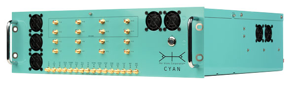
PER vices cyan software-defined radio for GNSS/PNT applications. (Photo: Per Vices)
Per Vices Corporation
Our latest product in this area is our Cyan SDR, which offers up to 16 radio chains, tuning frequency spanning all GNSS/PNT frequency bands (near DC to 18 GHz), a high performance FPGA SoC on-board (Intel/Altera Stratix 10), and multiple inputs and outputs for timing and synchronization with other equipment. This system has been utilized for many applications in this space due to its flexibility, performance, form factor (19″ 3U), and value.
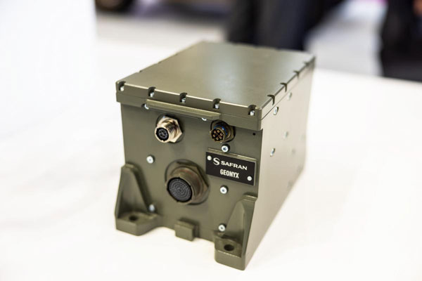
SAFran federal systems’ Geonyx inertial navigation solution, which can be integrated with VersaPNT, Safran’s all-in-one Assured PNT device. (Photo: Safran Federal Systems)
Safran Federal Systems
Safran’s Versa-PNT product coupled with a Geonyx inertial navigator offers rubidium oscillator precision timing, M-Code receiver and navigation-grade inertial technology, all in a package that can support land or maritime operations. More specifically, this package delivers:
P — M-Code receiver.
N — < 0.02% drift over the traveled distance (~2 m over 10 km, GPS accuracy).
T — One-day holdover below 1 µs.
Photo: Spirent Communications
Spirent Federal Systems
The PNT X is Spirent’s innovative sixth-generation simulation platform, which launched at the end of April and will debut at the ION JNC 2024 in June. PNT X offers a new era in NAVWAR testing, with a record 140 dB high dynamic range to simulate high-powered jammers and spoofers. It offers a 2,000+ Hz update rate for a highly accurate representation of the motion of missiles, rockets, and UAVs, thereby guaranteeing the integrity of test results.
The platform includes spatial awareness simulation for jammers and signals of opportunity, overlaying motion on user-defined signals and jammers alongside the simulation of the local environment and terrain.
The PNT X uses Spirent’s custom-built software-defined radios to extend capacity, automation and ease of use for testing current and future PNT sources. Designed for secure environments, the simulation solution features the first M-Code Regional Military Protection (RMP) test capability. Spirent experts are available to assist with generating test scenarios and capitalizing on new automation and interoperability features.
Syntony
The CRPA simulator that we will market together with Keysight will support all available GNSS signals and carrier frequencies. It also will be expandable by a software upgrade to LEO PNT in the near future. With typically four or eight channels,130dB of J/S, and based on the unique generator of Keysight VXG-C (2.5 Ghz instantaneous bandwidth, providing high-level phase synchronization all along the band), it will generate all the GNSS signals in L and S bands through one RF channel, bringing unrivaled performance and ease of calibration.