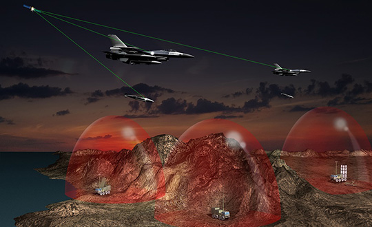
The U.S. Air Force has selected an anti-jam GPS receiver from Collins Aerospace (through the division formerly known as Rockwell Collins) for Air National Guard and Air Force Reserve F-16 fighter aircraft.
The U.S. Air Force Life Cycle Management Center (USAF AFLCMC) chose Collins Aerospace to supply its latest-generation Digital GPS Anti-Jam Receiver (DIGAR), designed to prevent jamming of GPS signals.
The DIGAR receivers will provide highly reliable navigation for U.S. Air National Guard and U.S. Air Force Reserve F-16 aircraft operating in contested, electromagnetic environments.
This will be the first combat fighter aircraft to be installed with the latest version of the receiver.
“As enemies continue to find new ways to affect the ability to navigate, the latest DIGAR will provide the highest level of protection available so our warfighters can execute missions with precision and accuracy,” said Troy Brunk, vice president and general manager, Communication, Navigation & Electronic Warfare Solutions for Collins Aerospace.
Image: Collins Aerospace
Integration of the DIGAR requires no changes to existing operational flight programs or A-kit aircraft wiring, lowering the risk and cost involved to upgrade.
Built on an open systems architecture, the DIGAR is designed for use across a variety of aircraft platforms that include rotary wing, fixed-wing fighter, bomber, transport aircraft and small to large unmanned aerial systems.
DIGAR is a form, fit replacement for existing antenna electronic systems with demonstrated performance that exceeds legacy capability, the company said.
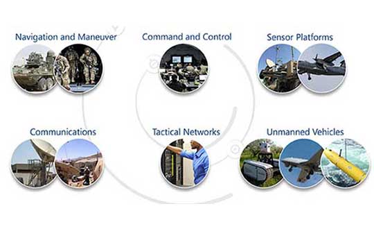
DIGAR Features
Superior digital beamforming or nulling anti-jam
Up to 16 simultaneous beams for superior jamming immunity to 125+ dB J/S performance (beamsteering mode, actual performance is classified.)
Two- to seven-element CRPA compatible
Simultaneous L1/L2 protection
Supports Y-code and M-code Anti-jam
Supports STAP/SFAP beamforming
Two form factors: DIGAR-200 (218 cubic inches) or DIGAR-300 (75 cubic inches)
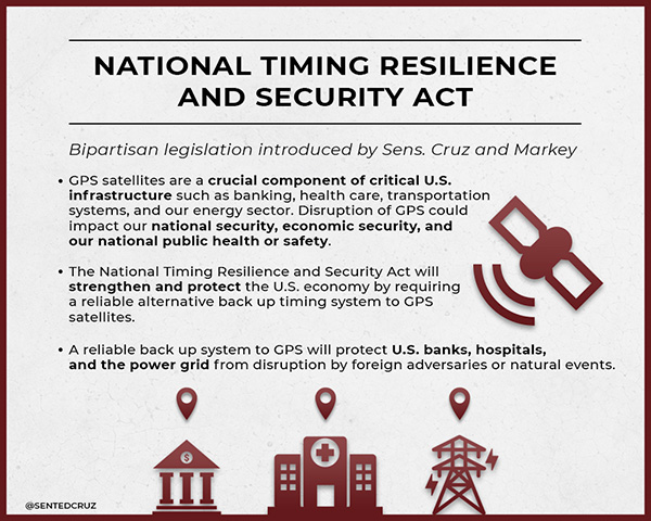
On Dec. 4, President Trump signed the Frank LoBiondo U.S. Coast Guard Authorization Act of 2018. Included in that bill was the National Timing Security and Resilience Act of 2018.
The act tasks the Secretary of Transportation with establishing a terrestrial backup timing system for GPS within two years.
Further, the bill ensures the availability of uncorrupted and non-degraded timing signals for military and civilian users in the event that GPS signals are corrupted, degraded, unreliable, or otherwise unavailable.
The law requires that, to the maximum extent possible, the backup system be:
terrestrial
wireless
synchronized to UTC
difficult to disrupt
able to penetrate underground and inside buildings
capable of deployment to remote locations
expandable to provide position, navigation and timing (PNT), and
able to work in concert with similar systems such as eLoran.
It also has provisions for the government to be able to establish the system through a commercial entity should it elect to do so. In such a case, it establishes several provisions that such a contract must meet.
Image: @SENTEDCRUZ
Timing a critical area. Timing has been an area of increasing focus and concern for both industry and government.
The U.S. Alliance for Telecommunications Industry Solutions (ATIS), the standards body for the wireless industry, has cited GPS timing as a point of failure for wireless systems. Last year ATIS wrote to key senators, encouraging them to establish an eLoran system to provide a second and much more resilient timing source for America.
In 2015 and 2016, the U.S. National Institutes of Standards and Technology issued reports that said America’s timing infrastructure was insufficient to support the growing internet of things (IOT).
The bill was sponsored by a broad coalition in the House led by Congressmen John Garamendi (D-CA) and Duncan Hunter (R-CA). Senators Ted Cruz (R-TX) and Ed Markey (D-MA) led the effort in the Senate, where the bill passed with an overwhelming majority.
U.S. Sens. Ted Cruz (R-Texas) and Ed Markey (D-Mass.) issued the following statements. “Establishing a reliable alternative timing system to GPS satellites is crucial to the national and economic security of the United States,” Sen. Cruz said. “If the current system were disrupted for even just a few hours, there would be an immediate threat to the American people, the economy, and our very way of life. Thankfully, Congress recognized the importance of addressing this issue. I am grateful for Sen. Markey’s leadership, and commend President Trump for signing this bill into law.”
“The nation’s banking, communications, electricity, and transportation sectors rely on the precise timing provided by GPS,” Sen. Markey said. “We cannot allow this vital system to be imperiled by natural phenomenon like solar flares or coordinated attacks like jamming. I am so proud that President Trump has signed this important bill into law, and I thank for Senator Cruz for partnering on policy that will enhance the resilience and reliability of this critical infrastructure.”
Defense attempt. Similar legislation that would have placed the responsibility for a terrestrial GPS backup system with the Department of Defense was introduced in 2015. While this was done with the acquiescence of senior DOD leadership, when the department later determined it did not want the responsibility, the measure failed.
While this new law is not a funding bill, Congress provided $10M for a technology demonstration in 2018. Also, having a law in place requiring the system paves the way for funding in future appropriations bills.
NATO conducted its largest military exercise since the Cold War in the frigid waters and icy mountains of Norway Oct. 25-Nov. 7.
During the final days of the Trident Juncture exercise, GPS signals guiding ships, aircraft, tanks, trucks and troops began to fail. Tracking screens flickered and positions were suddenly wrong from a few meters to hundreds of kilometers.
Civilian airliners, cars, trucks, cargo ships and smartphones operating in and around Norway and Finland experienced similar disruptions. Norway-based airline Wideroe told The Barents Observer that its pilots were reporting the loss of GPS signals when flying to airports in northern Norway and Finland. Airfields affected ranged from Kirkenes, on Norway’s border with Russia, to Lyngen in Troms, much further west.
Russia is the chief suspect of jamming the signals in reaction to the massive size and proximity of the military exercises. Russia also has recently conducted massive military exercises in the Baltics.
“It is possible that Russia has been the disrupting party in this,” Finland’s Prime Minster Juha Sipila told local media. “Russia is known to possess such capabilities.”
Trident Juncture involved all 29 NATO alliance members. Neutral Sweden and Finland also took part amid growing uncertainty over Russia’s ambitions in the tense region.
A free lesson for those in charge of critical infrastructure systems such as the power grid, communications, financial markets, emergency services, and industrial control.
Many of these systems have functioned smoothly and efficiently for years, thanks to the precise timing provided by GPS receivers. That could change, suddenly and without warning, if predictive and preventative steps are not taken.
The GPS receivers somewhere near the hearts of these critical systems, if not thoroughly vetted, tested and checked for up-to-dateness, could constitute a vulnerability — a vulnerability that would be catastrophically exposed on April 6, 2019. In 6 months’ time.
Image: Orolia
The GPS constellation transmits the proper date and time to all receivers, worldwide, by supplying the current week and the current number of seconds into the week. This enables the receiver to translate the date and time into a more typical format: day, month, year, and time of day. Infrastructure systems use the precise timing to synchronize many complex operations across their respective networks. Critically, the field that contains the week number is a 10-bit binary number. This limits the range of the week number to 0 – 1023, or 1024 total weeks.
GPS week zero started January 6, 1980. The 1,024 weeks counter ran out and rolled over on August 21, 1999. The week counter then reset to zero, and it has been recounting ever since. The next time the counter will reach week 1,023 and roll over to zero is on April 6, 2019.
If the GPS receiver is new or has received firmware updates, it can accommodate and adjust for this change. But do you know for sure? Only if you test. Otherwise, your critical systems may go into a time warp, 19.7 years out of date. Visualize that discrepancy rippling outward from the core component of a critical timing system throughout your infrastructure. Or, simply not working at all.
It is incumbent upon all managers to verify that such an issue will not occur — well before its possibility arises. At a minimum, experts recommend consulting your receiver manufacturer to confirm that the issue has been fully tested and will not occur. Many manufacturers have already issued compliance statements, and are expected to continue doing so over the next year, up until the event occurs.
To be sure that your system will not experience any failures related to this issue, it is possible to test for this event using a GPS/GNSS simulator. The requirements for the simulator are straightforward. The basic yet key information necessary to undertake such testing will be communicated in a free webinar on Thursday, November 15.
The panel of expert speakers includes Lisa Perdue, product manager and applications engineer, Orolia; Stefania Römisch, leader, the Atomic Standards Group at the National Institute of Standards and Technology; and Dana Goward, president, Resilient Navigation and Timing Foundation.
You may register for this free webinar here, to attend it live or download it for later viewing at your convenience.
Here is a useful reference from the last time the rollover occurred, with a mention of the next one.
Photo: Technical University of Eindhoven
Eindhoven, the Netherlands, is home to the Eindhoven University of Technology, an incubator for technology startups where many scientists active in GPS research and in the direction of the Galileo satellite navigation program have trained.
Tectonics is the study of plates in the Earth’s crust that move in different directions and speeds. To study plate motion, GPS instruments are anchored firmly in bedrock to measure how it moves, infinitesimally yet measurably, thanks to the nanosecond timing provided by the GPS constellation and interpreted by properly calibrated and updated instruments.
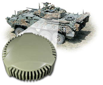
NovAtel’s GPS Anti-Jam Technology (GAJT) now rides into battle and military exercises aboard the Canadian Army’s Artillery Observation Post Vehicles (OPV) that have been fitted with the GAJT‑710ML antenna.
OPVs are highly mobile vehicles that perform observation, reconnaissance and patrolling missions, surveying and acquiring strategic targets and relaying instant, accurate target coordinates acquisition to artillery fire command systems. With their exposed position on the frontlines of the battlefield, OPVs can encounter severe GPS jamming aimed at crippling their capabilities. OPVs require reliable Position, Navigation and Timing (PNT) not only to safely and effectively navigate on the battlefield, but to provide reliable information to artillery in the rear.
GAJT provides protection for GPS navigation and precise timing receivers from intentional jamming in electronic attacks, ensuring that the satellite signals necessary to compute position and time are always available.
“GAJT allows us to have confidence that the position information from the GPS constellation is assured.” said Major Mike Moulton, the project manager in the Directorate of Land Communication Systems Program Management.
NovAtel’s GAJT is a retrofittable system. A military-off-the-shelf (MOTS) product, it comes in versions suitable for land or sea applications and smaller platforms such as unmanned aerial vehicles (UAVs). The antenna works with an array of military and civil receivers, including the Army’s handheld Defense Advanced GPS Receiver (DAGR), other military receivers using SAASM and M-Code, and with civil receivers.
“GAJT scrubs off unwanted signals. It differentiates between what we can recognize as a signal coming from a satellite and something anomalous, which could be interference or deliberate jamming,” explained Peter Soar, NovAtel’s Business Development Manager for defence. “GAJT does not contain a GPS receiver, but works with the receiver that’s already installed. So GAJT faithfully passes the good satellite signals to the receiver which then operates functions such as integrity monitoring in its normal way. GAJT is in use operationally and has been shipped to 16 allied nations around the globe.”
GAJT is a null-forming antenna system that ensures that satellite signals necessary to compute position and time remain available. There is no need to replace the GPS receiver that’s already installed, as GAJT works with both civil and military receivers operating in the GPS L1 and L2 bands. It is ready for M-Code, is a non-ITAR product and is readily available to authorized customers.
Trials with the Canadian Army’s testing unit validated the technology, maintaining access to the GPS signal in an adverse signal environment. It also gave NovAtel engineers a detailed unclassified report on the trial findings and recommendations. The feedback helped NovAtel modify GAJT into a stronger product. The GAJT-710ML antennas were delivered earlier this year, and the Army worked with General Dynamics Missions Systems Canada, the prime contractor for the mission systems on the OPV, to integrate the antenna aboard the vehicle.
“GAJT is a Canadian success story. It is 100 percent produced in Canada and sourced from Canadian components. I think that the Directorate of Land Communication Systems Program Management have shown there is excellent technology in Canada that can be leveraged to meet the Army’s requirements in a very rapid manner,” added Moulton.
This story uses some quotes that first appeared in “Out of a Jam,” an article by Chris Thatcher in Canadian Army Today.
KuRFS radars address urgent operational need against drone threats.
The U.S. Army awarded Raytheon Company a $191 million contract for Ku-band radio frequency radars. KuRFS, an advanced electronically scanned array system, fills an immediate U.S. Army operational need for a counter-unmanned aerial vehicle radar, Raytheon said.
Already deployed, KuRFS delivers precision fire control as well as “sense and warn” capability for multiple missions including detection of swarming UAS threats, as well as rocket, artillery and mortar threats.
Raytheon’s KuRFS radar. (Photo: Raytheon)
“Seeing threats — like swarming drones — as soon as possible on the battlefield is essential to protecting critical assets and saving soldiers’ lives,” said Andrew Hajek, senior director of tactical radars at Raytheon Integrated Defense Systems. “KuRFS makes this possible by delivering a unique combination 360-degree situational awareness, precision and mobility.”
KuRFS enables defense against multiple threat types through integration with the Land-Based Phalanx Weapon System, 50-caliber guns and 30-mm cannons. The radar also supports high-energy laser and the Coyote weapon system in both a ground-mounted or vehicle-mounted configuration, Raytheon said.
Raytheon’ KuRFS is able to quickly address the urgent needs of the army through a model of rapid-turn development and deployment, the company added. This reduces time to fielding, while providing enhanced flexibility to adapt to a quickly-changing threat environment in the drone space.
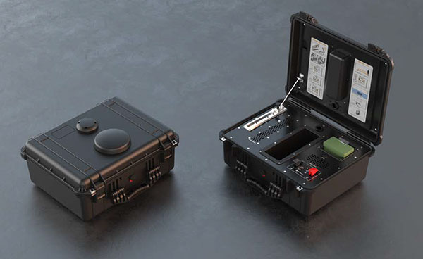
DroneShield has launched DroneNode in response to end-user requirements.
DroneNode is an evolution of the company’s DroneCannon product. It is a portable, compact and inconspicuous counter-drone jamming device that law enforcement can use at large outdoor events without raising public concern.
DroneNode comes in a portable case approximately 50 x 50 centimeters square. It can be set up in seconds and requires very little training to operate, the company said.
It can simultaneously jam 2.4 GHz, 5.8 GHz and GNSS L1 and L2 bands up to one kilometer, causing drones to return to their point of origin or land. DroneNode is also effective against swarm attacks. Emergency broadcasts, cellphone communication and other dedicated channels will not be affected.
According to the company, DroneNode’s covert design makes it a suitable counter-drone solution for public events where protection from drone threats is a priority. Designed within a rugged carry case, DroneNode is easy to transport and is protected from the elements.
DroneNode is powered by a NATO-approved self contained battery with room for a second battery stored in the accessories tray.
“The release of DroneNode continues DroneShield’s leadership in drone security for public events,” said Oleg Vornik, DroneShield’s CEO. “DroneShield’s recent credentials in the area include the 2018 Olympics, the 2018 Commonwealth Games, 2018 ASEAN-Australia Special Summit, the 2017 Hawaii Ironman World Championship, and the 2015 to 2017 Boston Marathons. The company’s products are well positioned to protect large public gatherings globally.”
According to DroneShield, the product is particularly relevant given the recent drone attack on the Venezuelan president and the high-profile mail bomb terrorist attacks in the United States, heightening the awareness of law enforcement globally to potential threats to high-profile political targets.
A Venezuela soldier received head injuries in a the drone attack against the president. (Photo: Released by Xinhua News Agency)
FCC Authorization Pending. DroneNode and DroneCannon have not been authorized as required by the U.S. Federal Communications Commission (FCC). The devices are not, and may not be, offered for sale or lease, or sold or leased, in the United States, other than to the U.S. government and its agencies, until authorization is obtained.
The use of such devices in the United States by other persons or entities, including state or local government agencies, is prohibited by federal law. Laws limiting the availability of such devices of certain types of users may apply in other jurisdictions, and any sales will be conducted only in compliance with the applicable laws.
In a 50-page report to the U.S. Senate Armed Services Committee, the government’s General Accounting Office (GAO) finds that U.S. weapons systems are, almost across the board, highly vulnerable to cyber-attack. Furthermore, the Department of Defense (DoD) has gotten off to “a late start” in prioritizing cybersecurity, and has only “a nascent understanding” of how to develop more protected weapons systems. The October 2018 report, “Weapons Systems Cybersecurity,” is subtitled “DoD Just Beginning to Grapple with Scale of Vulnerabilities.”
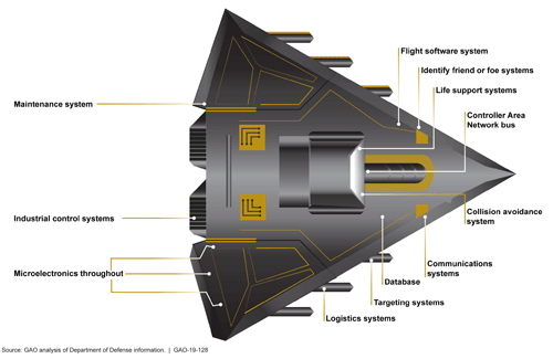
[Image above: Figure 2 from the GAO report: Embedded Software and Information Technology Systems Are Pervasive in Weapon Systems, represented via Fictitious Weapon System for Classification Reasons). Source: GAO analysis of Department of Defense information, GAO-19-128.]
GPS can figure to be among these threatened systems, and GPS guidance aboard many munitions and almost all platforms vastly expands the danger. The satnav system is not mentioned by name in the report (“To present information in an unclassified format, we do not disclose details regarding weapon system vulnerabilities, which program offices we interviewed, or which cybersecurity assessments we reviewed.”), and the word navigation surfaces only once, but it’s an alarming appearance:
“Weapon systems are dependent on external systems, such as positioning and navigation systems and command and control systems in order to carry out their missions—and their missions can be compromised by attacks on those other systems. A successful attack on one of the systems the weapon depends on can potentially limit the weapon’s effectiveness, prevent it from achieving its mission, or even cause physical damage and loss of life.”
The latter scenario could occur if a GPS-guided armament were hacked and rerouted to a civilian target, for example.
The GAO states that it warned as far back as 2015, and in repeated instances since that date, that federal and contractor systems face an evolving array of cyber-based threats, including criminals, hackers, adversarial nations, and terrorists. “Threats can range from relatively unskilled “script kiddies” who only use existing computer scripts or code to hack into computers, to well-resourced and highly skilled advanced threats who not only have sophisticated hacking skills, but also normally gather detailed knowledge of the systems they attack.”
Networks, Computers Increase Vulnerabilty
The increasingly computerized and networked nature of the U.S. military’s weapons contributes to their vulnerability. As weapon systems become more software- and IT-dependent and more networked, they actually become more vulnerable to cyber-invasion. Networks can be used as a pathway from one accessed weapon to attack other systems.
“Nevertheless,” the report adds, “until recently, DOD did not prioritize cybersecurity in weapon systems acquisitions. . . . DOD is in the early stage of trying to understand how to apply cybersecurity to weapon systems.”
As the GPS constellation — the satellites themselves as well as the ground control system — become more software-reliant, including the ability to modify signals by remote software command, this has to be a growing concern for the U.S. Air Force. Difficulties with cyber-proofing the next-generation ground control system, OCX, have been suspected as a leading cause of extended delivery delay in that program.
DoD officials reportedly confided that it will take time — and possibly some missteps — to learn what does and does not work in combatting cyber-attacks on weapon systems.
Separately, a UK defense expert consultant stated that Russia had “stolen a march on using cyber-capabilities at a tactical level on the battlefield.” As reported last year in GPS World, Black Sea spoofing incidents aroused suspicion that Russia was testing a new counter-combat technique.
Another spoofing expert said at the time, “It’s long been assumed that Russia, China and other nations (including the U.S.) have the technology to carry out a spoofing attack. What’s surprising is Russia’s willingness to use it openly and somewhat indiscriminately. It does fit nicely into what has been called Russian disinformation technology.”
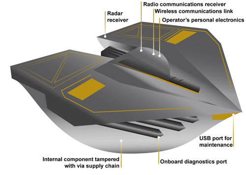
Figure 3 from the GAO report: Weapons Include Numerous Interfaces That Can Be Used as Pathways to Access the System (Represented via Fictitious Weapon System for Classification Reasons) Source: GAO analysis of Department of Defense information, GAO-19-128.
The amount of software embedded in weapon systems and subsystems has increased exponentially, expanding the respective weapons’ vulnerable surfaces. According to the military’s Director of Operational Test and Evaluation, “any exchange of information is a potential access point for an adversary. Even “air gapped” systems that do not directly connect to the Internet for security reasons could potentially be accessed by other means, such as USB devices and compact discs. Weapon systems have a wide variety of interfaces, some of which are not obvious, that could be used as pathways for adversaries to access the systems, as is shown in Figure 3.”
If attackers can access one of those systems, they may be able to reach any of the others through connecting networks.
Figure 4 from the GAO report: Weapon Systems Are Connected to Networks That May Connect to Many Other Systems (Notional Depiction for Classification Reasons)
Further, the DOT&E found that some networks were not survivable — that is, able to maintain critical capabilities under applicable threat — in a cyber-contested environment. The Defense Science Board concluded in 2013 that “the adversary is in our networks.”
The GAO adds that it and other organizations have been sounding off about such threats since the early 1990s — around the time that GPS itself became operational.
Tests of major military programs conducted between 2012 and 2017 revealed mission-critical cyber vulnerabilities that adversaries could compromise. “Test teams were able to gain unauthorized access and take full or partial control of these weapon systems in a short amount of time using relatively simple tools and techniques. . . . Once they gained initial access, test teams were often able to move throughout a system, escalating their privileges until they had taken full or partial control of a system.”
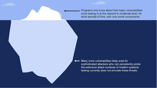
Figure 5: Vulnerabilities that the Department of Defense Is Aware of Likely Represent a Small Amount of Actual Vulnerabilities Due to Limitations in Cybersecurity Testing. Source: GAO analysis of Department of Defense information, GAO-19-128.
Beginning Steps
The Department of Defense is “still learning” how to address weapon system security and “still determining” what steps it may take. Implementation, once identified, will surely occupy an extended period. Complicating the picture, if DOD is able to make its newer systems more secure, yet connects them to older, vulnerable systems, the newer systems come into jeopardy.
Pass the Hash
A report appendix lists several different types of attacks with such pictorial names as: Man-in-the middle, Pass-the-hash, War driving, and Zero day exploit.
Respectively, these types of attacks connote:
• An eavesdropping attack in which the attacker intercepts to read or modify data communications to masquerade as one or more of the entities involved.
• Capturing an encrypted version of a username and password in order to authenticate to a server or service. The attacker does not have to decrypt the username and password (i.e., they do not actually know what they are), yet can still use them to log in to a system.
• Driving through cities and neighborhoods with a wireless-equipped computer — sometimes with a powerful antenna — searching for wireless networks potentially to exploit.
• Taking advantage of a security vulnerability previously unknown to the general public. In many cases, the exploit code is written by the same person who discovered the vulnerability. By writing an exploit for the previously unknown vulnerability, the attacker creates a potent threat since the compressed timeframe between public discoveries of both makes it difficult to defend against.
A 2016 wargame involving the Air Force and Navy at the Naval Postgraduate School. (Photo: U.S. Navy)
The 12th in a series of Air Force Space Command Wargames concluded Oct. 19 at the Maxwell Air Force Base in Alabama. Set in the year 2028, Schriever Wargame 2018 (SW 18) explored critical space and cyberspace issues in depth.
The objectives of the wargame centered on:
examining how international partner capabilities can deter an adversary from extending or escalating a conflict into space;
gaining insight into resiliency, deterrence, and warfighting through international partner synchronization of space and cyberspace operations;
exploring various combined command and control (C2) frameworks to employ and defend air, space and cyberspace capabilities in support of global and geographic / regional operations;
identifying the strategic and operational contributions of space and cyberspace in a multi-domain conflict; and
exploring partnerships framed by a whole of governments approach (International, Civil, Commercial) to combined space and cyberspace operations.
The SW 18 scenario depicted a notional peer space and cyberspace competitor seeking to achieve strategic goals by exploiting those domains. It included a global scenario with the focus of effort towards the U.S. Indo-Pacific Command (USINDOPACOM) Area of Responsibility.
The scenario also included full spectrum threats across diverse operating environments that challenged civilian and military leaders, planners and space system operators, as well as the capabilities they employ.
Approximately 350 military and civilian experts from more than 27 agencies around the country as well as from Australia, Canada, France, Germany, Japan, New Zealand, and the United Kingdom participated in the Wargame.
Agencies that participated included: Air Force Space Command, Army Space and Missile Defense Command, Naval Fleet Cyber Command, the National Reconnaissance Office, Executive Agent for Space Staff, Air Combat Command, Office of the Secretary of Defense, USINDOPACOM, U.S. Strategic Command, U.S. Special Operations Command, U.S. Northern Command, the Intelligence Community, National Aeronautics and Space Administration, Office of Homeland Security, Department of Transportation, Department of State and Department of Commerce.
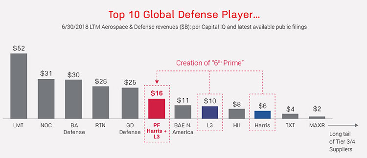
Harris Corporation and L3 Technologies Inc. have agreed to combine in an all-stock merger of equals to create a global defense technology leader focused on developing differentiated and mission-critical solutions for customers around the world.
The combined company, L3 Harris Technologies, will be the sixth largest defense company in the U.S. and a top 10 defense company globally, with approximately 48,000 employees and customers in more than 100 countries.
For 2018, the combined company is expected to generate net revenue of approximately $16 billion.
Image: from Fact Sheet by Harris and L3 Technologies
According to the press release, increased scale will enable the combined company to be more cost competitive, expand capabilities to provide end-to-end solutions across multiple domains of air, sea, land, space and cyber, enhance leadership in RF and spectrum technologies and establish a leading platform-agnostic supplier and integrator.
L3 Harris Technologies will be headquartered in Melbourne, Florida, and led by a team that reflects the strengths and capabilities of both companies and will share equally in the integration process, the companies said.
With a combined workforce of 22,500 engineers and scientists, the combined company plans to accelerate investment in select technologies to expand leadership in key strategic domains including national security.
Image: from Fact Sheet by Harris and L3 Technologies
Company Backgrounds
Harris Corporation is a solves customers’ mission-critical challenges by providing solutions that connect, inform and protect. Harris supports government and commercial customers in more than 100 countries and has approximately $6 billion in annual revenue. The company is organized into three business segments: Communication Systems, Electronic Systems and Space and Intelligence Systems.
L3 Technologies is a provider of global ISR, communications and electronic systems for military, homeland security and commercial aviation customers. With headquarters in New York City and approximately 31,000 employees worldwide, L3 Technologies develops advanced defense technologies and commercial solutions in pilot training, aviation security, night vision and EO/IR, weapons, maritime systems and space. The company reported 2017 sales of $9.6 billion.
CEO Statements and Leadership
“This transaction extends our position as a premier global defense technology company that unlocks additional growth opportunities and generates value for our customers, employees and shareholders,” said Harris chairman, president and CEO William M. Brown. “Combining our complementary franchises and extensive technology portfolios will enable us to accelerate innovation to better serve our customers, deliver significant operating synergies and produce strong free cash flow, which we will deploy to drive shareholder value. Integration planning is already underway, and from our extensive experience with integration, we are confident in our ability to realize $500 million of annual gross cost synergies and $3 billion of free cash flow by year 3.”
L3 Chairman, President and Chief Executive Officer, Christopher E. Kubasik said, “This merger creates greater benefits and growth opportunities than either company could have achieved alone. The companies were on similar growth trajectories and this combination accelerates the journey to becoming a more agile, integrated and innovative non-traditional 6th Prime focused on investing in important, next-generation technologies. L3 Harris Technologies will possess a wealth of technologies and a talented and engaged workforce. By unleashing this potential, we will strengthen our core franchises, expand into new and adjacent markets and enhance our global presence.”
The combined company’s board of directors will have 12 members, consisting of six directors from each company. William M. Brown will serve as chairman and chief executive officer, and Christopher E. Kubasik will serve as vice chairman, president and chief operating officer for the first two years following the closing of the transaction. For the third year, Brown will transition to executive chairman and Kubasik to chief executive officer, after which Kubasik will become chairman and chief executive officer.
Additional senior leadership positions for L3 Harris Technologies will be determined at a later date.
Shareholder Information
Under the terms of the merger agreement, which was unanimously approved by the boards of directors of both companies, L3 shareholders will receive a fixed exchange ratio of 1.30 shares of Harris common stock for each share of L3 common stock, consistent with the 60-trading day average exchange ratio of the two companies.
Upon completion of the merger, Harris shareholders will own approximately 54 percent and L3 shareholders will own approximately 46 percent of the combined company on a fully diluted basis.
The merger is expected to close in mid-calendar year 2019, subject to satisfaction of customary closing conditions, including receipt of regulatory approvals and approval by the shareholders of each company.
RealSense 3D camera is fully integrated to capture real-time detailed images
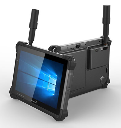
DT301X rugged tablet. (Photo: DT Research)
DT Research has released the DT301X rugged tablet, a lightweight military-grade tablet that is purpose-built to enhance the precision of crime and crash scene reconstruction, bridge and other construction inspections, and 3D surveying.
DT Research made the announcement at Intergeo, being held Oct. 16-18 in Frankfurt, Germany.
The DT301X rugged tablet has MIL spec and IP ratings, yet is lightweight — offering the versatility to be used in the field, office and vehicles, the company said. A high brightness 10.1-inch touchscreen offers flexible viewing in a wide range of lighting, and an Intel eighth-generation Core i5 or i7 processor offers high-performance while still being energy-efficient.
With high-capacity 60- or 90-watt hot-swappable batteries, the DT301X keeps working continuously, complemented with a variety of battery chargers so fully-charged batteries are always available.
The DT301X integrates the Intel RealSense depth camera, which provides real-time 3D imaging to shorten the workflow and create extremely accurate measurements for CAD, engineering, design, utility management and crime-scene forensics.
Scientific grade data, which is important for court evidence as well as building plans, just got easier and is now available to a wider group of workers. With this 3D camera technology, depth perception is integrated to add the most accurate image to make projects stay factual and consistent, DT Research said.
Optional data capture offered on the DT301X besides the 3D camera are a 2D barcode scanner for equipment/location tags, a dual-frequency GNSS module for real-time mapping and positioning, long-range Bluetooth for 1000-foot range, and 4G LTE mobile broadband for the latest in high speed communications.
The rugged tablet gives detailed accuracy combined with the latest 3D camera technology all in one device that is rugged and easy to use in the field.
“DT Research’s high-performance rugged tablet equipped with the RealSense depth camera combined with DotProduct’s Dot3D Scan software allows speedy and efficient field-to-office 3D workflows for a wide range of applications from construction verification to asset management to crime scene mapping,” said Tom Greaves, chief marketing officer at DotProduct.
The DT301X is built to operate in real-world situations, with an IP65 rating for water and dust, MIL-STD-810G for shock and vibration protection, and MIL-STD-461F for EMI and EMC tolerance. The tablet can be paired with a detachable keyboard for ease of use, and Wi-Fi and Bluetooth for smooth networking and constant communications.
The DT301X rugged tablet is compatible with existing applications with Microsoft Windows 10 IoT Enterprise operating systems for flexible integration, and it brings together the advanced workflow for data capture, accurate positioning and data transmitting.
Whether at the electrical substation, at the crash scene, or at the construction site, the DT301X is ideal for accurate measurements as well as other needed tasks, able to travel to wherever the work is.
The DT301X rugged tablet will be available in November 2018 from DT Research’s authorized resellers and partners.
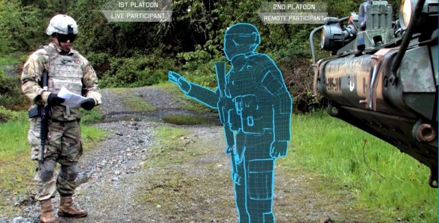
The U.S. Army considers virtual reality training as an important path ahead to prepare warfighters.
The U.S. Army awarded Bohemia Interactive Simulations (BISim) a major extension to demonstrate technologies for a cloud-enabled, virtual world training capability.
BISim is a global developer of advanced military training and simulation software.
The contract award helps meet the requirements of the Army’s Synthetic Training Environment (STE) initiative. STE aims to converge virtual, constructive and gaming training environments into a single unified architecture.
The ambitious STE project will enable simulation systems Army-wide to leverage a persistent virtual world for any imaginable training need, including support for multi-domain operations incorporating cyber and space.
Central to STE is a cloud-enabled One World Terrain (OWT) that will let warfighters conduct virtual training and complex simulations anywhere on a virtual representation of the Earth. OWT will leverage cloud technologies to deliver to the point of need, ensuring a common and high-fidelity whole-Earth terrain representation for a multitude of different simulation systems.
The Synthetic Training Environment will assess Soldiers in enhancing decision-making skills through an immersive environment. (Photo: U.S. Army)
“The U.S. Army’s vision for STE marks a monumental change in how they acquire, develop and deliver new simulation and virtual training technologies to soldiers,” said Pete Morrison, BISim’s co-CEO and chief product officer. “We’re honored to be selected to assist the Army in developing innovative solutions that will shape the future of how virtual training is used to enhance operational readiness.”
BISim has been developing its next generation of simulation technologies since 2014. The new technology suite includes a cutting-edge, military-specific whole-earth game engine, deterministic AI, an efficient geospatial terrain server and component-based development technology.
BISim technology underpins funded research and development for One World Terrain. Additionally, BISim recently demonstrated Reconfigurable Virtual Collective Trainer (RCVT) prototypes for STE. The latest OTA extension is a significant ramp up in the breadth and ambition of the technology being demonstrated.
BISim’s STE offering includes four core technologies uniquely suited to meeting future military simulation requirements (including U.S. Army requirements).
VBS Blue. A high-performance, whole-planet data ingestion and rendering engine with a very high level of procedural detail, designed to ingest any conceivable terrain data format as well as source data directly. VBS Blue will support networked (cloud) terrain paging and geo-specific insets as well as the latest graphics technologies. It provides photorealistic detail, and includes a massive vegetation library representing every region on Earth. The technology is highly applicable across all types of image generation and is optimized for many AR/VR applications.
STEWS. A geospatial data server that provides efficient networked access to the various data sources required for rendering applications. STEWS provides a curated database of terrain data layers that can be streamed into any STE-connected client application at run time (including non-BISim applications). Any application connected to STEWS can stream high fidelity terrain data in a performant manner. Both new and legacy terrain formats are supported through new STEWS plug-ins.
VBS Control. High fidelity, doctrinal and deterministic entity-level artificial intelligence that is uniquely suited to operation on whole-earth terrain. VBS Control runtime offers highly efficient real-time path planning that allows AI to move seamlessly through open, urban and interior spaces. The VBS Control Editor allows powerful new AI behaviors to be developed at both the individual entity level and at higher levels of command for land, sea and air assets.
Gears. A software development framework that defines a standard way for components to communicate through formal interfaces. Gears uses a component-based architecture to promote rapid development by building applications from self-contained systems and having them communicate via formally defined interfaces. This allows functionality to be reused and avoids the complexity of tightly coupled systems. See www.gears.studio for more information.
The Army also selected BISim for a five-year contract to support their Games for Training Program and BISim’s technology is being rolled out on CCTT (the U.S. Army’s largest ground simulator training program).