Category: Mapping

  • Nortek enables USV navigation in GNSS-denied environments

    Nortek enables USV navigation in GNSS-denied environments

    Nortek’s DVL 333 Surface, designed specifically for uncrewed surface vessels (USVs), enables USVs to maintain position or navigate when GNSS is lost.

    Uncrewed surface vessels (USVs), often called sea drones, help monitor, map and secure the world’s oceans, performing tasks and surveys for less expense and risk than traditional crewed vessels. USVs are used in environmental monitoring, offshore inspection, subsea infrastructure protection, and defense missions such as intelligence, surveillance and reconnaissance (ISR).

    USVs require reliable navigation and positioning information, particularly when performing autonomous operations. This information typically comes from GNSS.

    But during GNSS outages, USV operators are turning to alternative sensors for positioning. Without GNSS, a sole inertial navigation system (INS) on a vessel quickly drifts outside of acceptable levels when performing dead-reckoning navigation. By adding a Doppler Velocity Log (DVL) to the USV, operators can perform long-distance, dead-reckoning-based positioning with much lower drift.

    USVs using INS in the absence of GNSS achieve improved accuracy with the addition of a DVL, which limits drift inherent to INS-only navigation. (Image: Nortek)
    USVs using INS in the absence of GNSS achieve improved accuracy with the addition of a DVL, which limits drift inherent to INS-only navigation. (Image: Nortek)

    In subsea navigation systems, DVLs provide vehicle velocity information using acoustic returns from the seabed. Because DVLs offer an accurate velocity estimate with no drift, combining a DVL with an INS constrains the drift that would accumulate with an INS alone. Using a DVL allows USVs to maintain position or even navigate without requiring GNSS information, enabling fully autonomous navigation independent of potentially vulnerable signals.

    However, deploying DVLs on surface vessels introduces its own set of engineering and operational challenges. Conventional DVLs typically feature protruding transducer heads that are not flush with a vessel’s hull — challenging on smaller or high-speed vessels.

    The DVL 333 Surface. (Photo: Nortek)
    The DVL 333 Surface. (Photo: Nortek)

    The compact Nortek DVL 333 Surface is designed for flush-hull installation, minimizing drag and protrusion below the hull line. It features a concave, fluid-filled transducer cavity sealed with an acoustic window, allowing for full control of sound velocity and eliminating the need for a hull-mounted speed-of-sound sensor.

    When paired with a high-grade INS, the DVL 333 Surface delivers accurate position updates even during GNSS outages or interference. Its 300-meter bottom-track range supports fully autonomous operation in coastal waters, while a water-track mode extends functionality in deeper environments where the bottom is out of range. The DVL333 Surface can also be upgraded to Nortek’s VM Operations vessel-mounted ADCP system. For ease of maintenance, an optional type-certified sea valve allows in-water servicing without dry-docking.

    Validating capabilities in the field

    The capabilities of the DVL 333 Surface were demonstrated during field trials in the Oslofjord, an inlet in Norway. The test site presented conditions representative of complex coastal environments, where depth can vary significantly over short distances, and the seabed composition ranges from soft sediment to rock. Unlike uniform test sites with flat, sandy bottoms, the Oslofjord provides a realistic proving ground for challenging navigation scenarios.

    “Our goal was to demonstrate that a surface vessel can maintain precise positional accuracy even during a complete GNSS blackout, and to do so in truly challenging coastal conditions,” said Torstein Pedersen, Nortek.

    Nortek's DVL 333 Surface installed in a fairing ready for testing in the Oslofjord. (Photo: Nortek)
    Nortek’s DVL 333 Surface installed in a fairing ready for testing in the Oslofjord. (Photo: Nortek)

    The navigation tests were carried out using a DVL 333 Surface integrated with an Exail PHINS 6000 INS. Although the trial track was relatively short, the system’s performance quickly stabilized, achieving a stable, long-term accuracy of approximately 0.05% of distance traveled (for instance, 50 cm error each 1 km traveled). When bottom track was disabled (simulating operation outside of the DVL 333 Surface’s 300 m bottom track range) and only water track was used with the PHINS INS, the horizontal position error remained within 8 meters over a three-hour run, with the DVL operating solely in water-track mode. In this mode, the INS estimates background currents, which were accurately estimated as weak, stationary currents.

    “We were particularly impressed with the performance of the system when using just water track mode,” Pedersen said. “The Exail INS was able to use the water track information to estimate currents and correct for them in the navigation, which is not an easy task to do with accuracy over extended periods. This performance is critical for open water navigation.”

    These results confirm that the DVL 333 Surface delivers reliable navigation performance in variable bottom conditions and without a direct speed-of-sound measurement. More importantly, they demonstrate the availability of a commercially available DVL that overcomes the challenges typically faced when adapting subsurface systems for surface platforms.

    Positional error as a function of distance traveled, showing long-term accuracy settling below 0.05% over a transit distance of >6 km. (Image: Nortek)
    Positional error as a function of distance traveled, showing long-term accuracy settling below 0.05% over a transit distance of >6 km. (Image: Nortek)
  • Seeing the unseen: How AI-powered geospatial tech is transforming utility safety

    Seeing the unseen: How AI-powered geospatial tech is transforming utility safety

    Every six minutes, somewhere in the United States, an underground utility line is damaged by careless excavation. Such incidents not only disrupt electrical, gas, and other services but also create serious environmental hazards. For example, a broken gas line could trigger an explosion that puts people and property at risk. Utilities and local distribution companies (LDCs) are embracing geospatial analytics and artificial intelligence (AI) to prevent or limit damage to buried cables and pipelines.

    The Common Ground Alliance (CGA) estimates that in 2019, excavation damage cost U.S. utilities $30 billion, including the cost of lost service, emergency response, and repairs. The Pipeline and Hazardous Materials Safety Administration (PHMSA) estimates that pipeline excavation incidents continue to rise, averaging 1.45 per day in 2024.

    Despite local regulations and 811 lines to “call before you dig,” excavation breaches continue to grow due to a lack of visibility and up-to-date information about underground lines. Utilities can’t give contractors and excavation crews accurate information about buried assets that are invisible from the surface.

    Satellite imaging and spectral sensing technology provide utilities with the means to monitor rights-of-way, identify excavation threats, and troubleshoot problems such as gas and water leaks. AI-powered geospatial analytics are the modern canary in the coal mine for hazardous leaks and service disruptions.

    Keeping Track of Buried Service Assets

    Keeping track of underground assets is an ongoing challenge for pipeline operators, utilities, and LDCs. The traditional method of tracking buried assets is periodic field observations. Right-of-way inspections and 811 locate ticket programs are typically initiated before third-party excavations, but these manual methods leave a dangerous visibility gap.

    Inspections are needed every 30 to 90 days, which is costly since they require rolling trucks with human inspectors. Manual inspections can also provide only limited coverage, particularly in remote and hard-to-access areas. Even with regularly scheduled inspections, encroachments may go undetected for weeks or months. The result is a vulnerability window between inspections.

    The CGA reports that failure to notify 811 and inaccurate location information are among the top contributors to excavation incidents. Even when appropriate dig notices are filed, construction grading or trenching often begins before infrastructure owners can respond to dig requests.

    Advances in remote sensing, AI, and GIS now enable utilities to monitor rights-of-way from 270 miles up. Using satellite imaging and AI algorithms, utilities can continuously monitor pipeline and cable corridors and help close the visibility gap. Commercial satellite images from providers such as Airbus and Vantor (formerly known as Maxar) can provide high-resolution imagery for cloud-based AI processing that can detect changes as small as 30 centimeters, about the size of a dinner plate. Using satellite imaging is also faster and more cost-effective than using drones or aircraft, because cloud computing resources can analyze images in hours, rather than days or weeks.

    High-resolution imagery is necessary for specific, accurate alerts. (Photo: Satelytics)
    High-resolution imagery is necessary for specific, accurate alerts. (Photo: Satelytics)

    To power geospatial analytics, remote sensing technology (RST) captures multispectral and hyperspectral data from high-resolution satellite sensors, then uses AI-powered algorithms to analyze spectral signatures. Spectral imaging can detect a wide range of surface activity, including soil disturbances, vegetation changes, soil grading and trenching, new construction starts, heavy equipment use, new access roads, and encroachment on utility easements; activities that could indicate a risk to buried cables and pipelines.

    Integrating Geospatial AI with ArcGIS

    To make potential problems easier to identify, high-resolution images and geospatial analyses can be fused with GIS asset layers and corridor models to pinpoint anomalies that could indicate excavations or construction that interfere with utility rights-of-way.

    Utilities that already use ArcGIS as their system of record can readily integrate results from geospatial analytics into existing workflows. For example, users can visualize and detect disturbed layers using ArcGIS Pro, tracking surface risk trends and KPIs with ArcGIS dashboards.

    Monitoring the utility corridor for unwanted structures. (Image: Satelytics)
    Monitoring the utility corridor for unwanted structures. (Image: Satelytics)

    To show how this works, Southern Company, which owns Georgia Power, Alabama Power and Mississippi Power, needed to identify new construction along its service corridors to detect potential encroachments before construction. Southern Company established a quarterly monitoring schedule with Satelytics, a provider of cloud-based geospatial analytics software.

    Using data from the Pleiades 1A and 1B satellites, Satelytics captured multispectral imagery at 50-centimeter resolution, then used AI-poweredanalytics to detect changes, such as new barns, parking lots, or other construction. Encroachment alerts were delivered through the Satelytics web portal, and the geospatial data was transferred directly to Southern Company’s ArcGIS system via application programming interfaces (APIs).

    Southern Company then compared items flagged in the satellite images with field visits to fine-tune the AI models. Following the pilot program, the AI models were refined to flag only those encroachments that posed a danger or a problem.

    Flagging encroachment risks from space. (Image:: Satelytics)
    Flagging encroachment risks from space. (Image:: Satelytics)

    AI-powered geospatial analytics strengthens Enhanced Positive Response (EPR) by documenting risk locations, including map layers and images, and providing evidence of corridor conflicts and surface changes. While AI accelerates detection, ground truthing remains essential. As shown in our Southern Company example, on-site validation is required to improve machine learning algorithms to increase accuracy. Integrating Field Maps and Survey 123 into AI workflows can verify findings and prioritize responses.

    Using AI and GIS for Predictive Dig Safety

    Geospatial AI technology is becoming an essential tool for more than just excavation monitoring. Using AI to analyze satellite images offers other benefits, such as measuring gas leaks or tracking water and oil leaks. Combining AI, GIS, and historical data will soon be used for predictive excavation risk management, identifying high-risk areas in advance of filing an excavation permit.

    Predictive analytics will continue to play a larger role in excavation monitoring. AI analytics will provide construction forecasts and enable permit intelligence layers in GIS. The same data can power dynamic risk scoring dashboards and support three-dimensional corridor safety twins.

    As new building construction continues to boom, utilities are harnessing the latest technology to prevent excavation incidents and protect underground assets. Combining satellite imagery, AI, and GIS provides the advanced tools needed to maintain continuous asset awareness, closing the visibility gap for underground cables and pipelines. Pipeline operators, electric utilities, and LDCs are reducing operating costs and minimizing environmental impact by leveraging geospatial analytics powered by artificial intelligence.

    Sean Donegan is CEO of Satelytics, a company that uses cloud-based, geospatial analytics to analyze multispectral and hyperspectral imagery to identify pipeline leaks and other environmental issues. Donegan has over 30 years of experience building technology and software companies.

  • GrabMaps in Singapore tests high-accuracy GPS system

    GrabMaps in Singapore tests high-accuracy GPS system

    Grab Singapore has launched a pilot program that uses high-accuracy lane-level GPS positioning to enhance the navigation experience for its driver and delivery partners in Singapore.

    The pilot — rolled out in collaboration with Oppo, Qualcomm Technologies and Swift Navigation — also marks the first deployment of high-accuracy GPS positioning on mobile phones and app integration in Southeast Asia, delivering unprecedented outdoor location accuracy for Grab’s partners.

    Grab is a leading app in Southeast Asia, operating across the deliveries, mobility and digital financial services sectors. It enables location-based services in more than 800 cities in eight Southeast Asian countries: Cambodia, Indonesia, Malaysia, Myanmar, the Philippines, Singapore, Thailand and Vietnam.

    As part of its ongoing efforts to enhance the GrabMaps navigation experience, Grab continually explores new technologies to help improve accuracy and reliability for its driver and delivery partners. In dense urban environments such as Singapore’s high-rise buildings, multi-level roads, and underground networks can degrade standard GPS accuracy above 20 m, complicating navigation between pick-ups and drop-offs, and reducing ETA accuracy.

    By bringing together leading technology partners to create an advanced navigation system, Grab’s driver- and delivery-partners can now pinpoint their location with higher accuracy, improving navigation efficiency in GPS-challenging environments, while enabling smoother pick-ups and reduced cancellations.

    The pilot taps on the individual expertise of the following partners:

    • OPPO, which provides its Find N5 foldable phone with dual-frequency GNSS capable of supporting the latest positioning technology.
    • Qualcomm Technologies, which activates the Meter-Level Positioning for Mobile featured in the Snapdragon 8 Elite Mobile Platform that powers the OPPO Find N5, enabling real-time GPS correction signals.
    • Swift Navigation, which provides its cloud-based Skylark Precise Positioning Service that uses advanced atmospheric modeling to correct GPS signal errors and deliver 10x greater positioning accuracy. Skylark is built on top of a network of ground reference stations operated in partnership with network operators around the world, including Singapore Land Authority (SLA). SLA operates the Singapore Satellite Positioning Reference Network (SiReNT) which provides Skylark with accurate GNSS data to enable precise positioning for last mile ride hailing and logistics in Singapore.

    Together, these technologies power the pilot, with OPPO’s Find N5 foldable phone, Qualcomm Technologies’s Snapdragon 8 Elite Mobile Platform, and Swift Navigation’s Skylark working in concert to deliver precision navigation experiences.

    With results of the pilot, Grab plans to extend the enhanced positioning capability to its proprietary Karta devices in the near future — broadening access to precise navigation technology and ensuring more driver and delivery partners can benefit from it over time.

  • ComNav Technologies: Innovation makes a difference

    ComNav Technologies: Innovation makes a difference

    As the geospatial industry accelerates toward automation and intelligence, ComNav Technologies is redefining its role in the market. In this exclusive interview, ComNav leadership discusses the company’s transition in 2025 — evolving from a traditional GNSS hardware provider into a comprehensive solutions and services company that seamlessly integrates positioning, perception and cloud-based intelligence.

    As surveying evolves from manual, point-based measurement to automated, cloud-connected ecosystems, ComNav explains how they’re positioning themselves at the forefront of this industry transformation — empowering professionals to shift from repetitive fieldwork to high-value data processing and decision-making.

    What would you consider ComNav’s most significant breakthrough in 2025?

    Innovation — as our slogan says, “Innovation Makes a Difference.”

    In 2025, ComNav has achieved a key transformation from being primarily a GNSS hardware provider to becoming a comprehensive GNSS solution and service company. We are extending our capabilities beyond traditional receivers and boards into CORS network construction, cloud-based GNSS services, and intelligent software platforms.

    This transition marks a major step toward integrating hardware, software, and cloud services, allowing us to deliver not only precise positioning equipment but also complete, scalable solutions for global customers. It reflects our long-term commitment to driving innovation and shaping the future of intelligent navigation.

    What key improvements has your technology recently achieved?

    ComNav has made significant progress in multi-sensor fusion and core GNSS technology.

    We have advanced our real-time multi-sensor fusion technology, integrating GNSS, lidar, camera and IMU to deliver higher reliability and spatial awareness in complex environments. This innovation enables a shift from point-based measurements to full 3D spatial mapping, opening new possibilities for surveying, autonomous systems, and digital twin applications.

    ComNav's real-time multi-sensor fusion technology, integrates GNSS, lidar, camera and IMU to deliver higher reliability and spatial awareness in complex environments.
    ComNav’s real-time multi-sensor fusion technology, integrates GNSS, lidar, camera and IMU to deliver higher reliability and spatial awareness in complex environments.

      How is ComNav planning to advance its multi-frequency, multi-constellation GNSS technology in 2025? Which constellations are you now supporting?

      We proudly launched the fourth generation of our high-precision GNSS SoC chip, which integrates full-constellation, muti-frequency RF and BB into a single compact design. This chip offers higher positioning accuracy, lower power consumption, and improved anti-interference performance — setting a new benchmark for GNSS receiver technology.

      It employs multi-constellation simultaneous equation technology, ground-based and satellite-based augmentation technologies, SBAS technology, RAIM technology to deliver highly reliable position and attitude information to users. The chip supports various positioning modes, including RTK, RTD, PPP, PDP, SPP, and GNSS + INS, making it suitable for a wide range of complex high-precision positioning scenarios.

      Which industry sectors saw the most growth for ComNav solutions in 2025 – agriculture, construction, surveying, autonomous vehicles, or others? Are there any successful use cases you can share from these sectors?

      ComNav's Jupiter GNSS receiver integrates a 50-m laser, IMUm and camera technology.
      ComNav’s Jupiter GNSS receiver integrates a 50 m laser, IMUm and camera technology.

      In 2025, geospatial remained the fastest-growing for ComNav.

      Driving this growth is our newly launched Jupiter GNSS receiver, which integrates a 50-meter laser, IMU, and camera technology. This combination enables non-contact measurement, greatly enhancing operational efficiency.

      Our newly released LS600 laser scanner further expands this innovation. It combines advanced SLAM technology, a built-in RTK module for centimeter-level accuracy, and dual wide-angle cameras for vivid color capture. The LS600 significantly simplifies field workflows and allows users to easily obtain high-quality 3D point clouds, transforming traditional “single-point measurement” into multi-dimensional, intelligent data acquisition. This represents a major leap forward in efficiency, safety, and precision for complex surveying operations.

      The LS600 seeks to significantly simplify field workflows. It allows users to easily obtain high-quality 3D point clouds, transforming traditional “single-point measurement” into multi-dimensional, intelligent data acquisition.
      The LS600 seeks to significantly simplify field workflows. It allows users to easily obtain high-quality 3D point clouds, transforming traditional “single-point measurement” into multi-dimensional, intelligent data acquisition.

      At the same time, our agricultural segment has also achieved remarkable growth. The AG501 Pro supports a wide range of guide line designs and delivers operational accuracy of up to 2.5 cm. Continuous software updates and optimization have further improved user experience, making precision agriculture simpler and more efficient. It embodies our commitment to empowering smarter, more sustainable agricultural operations through GNSS innovation.

      Are there any new product lines we can expect to see launched next year?

      In 2026, ComNav will introduce a new generation of integrated lidar and RTK products, combining high-precision GNSS positioning with advanced laser scanning technology. This integration will enable professionals to capture both geometric and spatial data simultaneously, delivering faster, more comprehensive field data collection.

      We are also preparing to release an upgraded handheld laser RTK, designed for maximum portability and ease of use. With enhanced measurement accuracy, longer range, and improved connectivity, it will empower surveyors to perform rapid, precise measurements in a wide range of field environments.

      These new product lines reflect ComNav’s ongoing commitment to expanding its technology ecosystem — integrating positioning, perception, and intelligence into one cohesive solution.

      How do you see the industry evolving over the next year, and how is comNav positioning itself to stay ahead to market changes and challenges?

      We believe the geospatial industry is entering a new stage of intelligence and automation. The traditional boundary between field data collection and office data processing is rapidly disappearing. Surveying is evolving from manual, point-based measurement toward automated, intelligent, and cloud-connected workflows — where data captured in the field is seamlessly processed, analyzed, and visualized in the cloud.

      To stay ahead of this transformation, ComNav is focusing on intelligent integration — combining high-precision GNSS with sensors, AI algorithms, and cloud platforms. Our goal is to enable surveyors to shift their efforts from repetitive fieldwork to high-value, intelligent data processing and decision-making in the office.

      By investing in smart software, real-time cloud services, and integrated hardware platforms, ComNav is positioning itself as a key driver in building the next generation of intelligent geospatial ecosystems.

      The AG501 Pro supports a wide range of guide line designs and can deliver operational accuracy of up to 2.5 cm.
      The AG501 Pro supports a wide range of guide line designs and can deliver operational accuracy of up to 2.5 cm.
    1. Researcher recounts adventure updating GNSS stations in Bangladesh

      Researcher recounts adventure updating GNSS stations in Bangladesh

      The challenge of repairing GNSS stations in Bangladesh is recounted in a Nov. 6 article by Mike Steckler, a researcher with Columbia Climate School.

      Steckler has been conducting research in the country for 25 years. He previously installed a continuously operating reference station (CORS) network in the southern region of the country.

      Data from the network has enabled study of the tectonic motions of the Earth leading up to earthquakes. It also revealed the sinking of the land in the world’s largest delta to less than 1 mm/y.

      “I still find that amazing compared to the days before GNSS became routine,” he writes. “I’ve been at sea where the crew had to use sextants to estimate our position to within 10 miles.”

      Of 16 stations running in the country, only three (green) were transmitting data back to the U.S. “I have returned here once again with others to get them working again and add three new stations (white),” Steckler writes.

      Steckler was joined by a team from Dhaka University to visit the sites, make repairs and install new equipment.

      Read his full article at the Columbia Climate School website.

      Map of Bangladesh showing the locations of Steckler's GNSS sites and regions he is visiting. The green circles are working systems, the red ones need repair, and the white ones are new. The pink circles are monuments with no active system. (Image: Mike Steckler)
      Map of Bangladesh showing the locations of Steckler’s GNSS sites and regions he is visiting. The green circles are working systems, the red ones need repair, and the white ones are new. The pink circles are monuments with no active system. (Image: Mike Steckler)
    2. Trimble, California Surveying & Drafting Supply partner with Fresno State to address surveyor shortage

      Trimble, California Surveying & Drafting Supply partner with Fresno State to address surveyor shortage

      Trimble has provided advanced geospatial equipment to Fresno State’s Geomatics Engineering Program in collaboration with California Surveying & Drafting Supply, a Cansel company (CSDS). The equipment is designed to facilitate experiential learning in optical surveying, photogrammetry, GIS, GNSS and scanning workflows, helping to equip geomatics students with the skills needed for future careers. As part of this collaboration, Fresno State will open a Trimble Technology Lab on campus in 2026 as a place for students to get hands-on experience and training.

      As the nation’s first four-year, nationally accredited geomatics program and California’s only Accreditation Board for Engineering and Technology-accredited four-year offering, Fresno State has long been a hub for training the geospatial professionals who power land surveying companies throughout the Western U.S., including entities like Caltrans and PG&E. CSDS, with its expertise in bridging academic needs with industry solutions, was instrumental in bringing Trimble on board to expand the program’s equipment inventory, foster innovation and ensure the program’s sustainability as a talent pipeline for California’s geospatial industry.

      “This strategic alliance is key to revitalizing and aligning educational offerings with the cutting-edge tools that define the profession,” said Tom Cardenas, senior vice president at CSDS. “Beyond offering students a hands-on learning approach, this project establishes a scalable model for addressing the surveyor shortage through industry and education collaboration. It’s a clear commitment to reshaping the future of geospatial education in California.”

      The Bureau of Labor Statistics reports a significant decline from 56,200 employed surveyors in the U.S. in 2010 to 47,770 in 2020. In California, where more than 2,000 surveyors depend on advanced technologies to support a booming construction and utility sector, the shortage poses a tangible threat to projects ranging from highway expansions to renewable energy installations.

      “Fresno State is a critical pipeline for California’s geospatial workforce. The collaboration with CSDS and Trimble amplifies our collective mission to align educational offerings with the state-of-the-art tools that meet the demands of a rapidly evolving industry,” said Bryan Gibert, director of sales enablement at Trimble. “This collaboration is about creating an ecosystem that draws in talent and prepares them for immediate impact.”

      The equipment includes Trimble GNSS base receivers, data collectors and network capabilities; Trimble S7 robotic total stations; Trimble DiNi digital levels; Trimble X9 3D laser scanners with T10x tablets; and licenses for Trimble Business Center, Trimble RealWorks and other highly technical software such as Trimble’s aerial photogrammetry module for TBC and Trimble eCognition. Trimble also outfitted Fresno State’s Geomatics Engineering program with several C5 mechanical total stations for a complete, turnkey solution. Both Trimble and CSDS provide configuration, calibration and on-site training for the technology.

      “We emphasize hands-on training in our facility, complete with high-end computers, advanced distance learning tech and collaborative research projects with local agencies like CSDS,” said Scott Peterson, associate professor and program coordinator of the Geomatics Engineering Program at Fresno State. “While we had solid foundations from previous industry partnerships, we needed to expand with Trimble technologies to align our geomatics education with what the overwhelming majority of California professionals use every day. This turnkey solution, from GNSS to scanners and software, prepares our students for real-world challenges across geomatics and construction, leveraging our control network for practical training.”

    3. Scripps Institution of Oceanography expands geodetic program

      Scripps Institution of Oceanography expands geodetic program

      My September GPS World newsletter highlighted the new California Spatial Reference Network, labeled CSRN Epoch 2025.00. These coordinate changes will impact geospatial users across California, and understanding the transition process is important for preparing for the modernized National Spatial Reference System (NSRS), expected to be adopted in 2026.

      This newsletter will focus on the California Spatial Reference Center (CSRC) and the Geodetic Program at Scripps Institution of Oceanography (SIO).

      CSRC, founded in 1997 and formally dedicated in 2001, develops and maintains a modern network of GPS control stations to provide a reliable spatial reference system for California. Created as a partnership of surveyors, engineers, GIS professionals, the National Geodetic Survey (NGS), Caltrans, and the geodetic and geophysical communities, the CSRC’s mission is to produce a self-sustaining, up-to-date geodetic control network for the state.

      The CSRC holds Coordinating Council meetings to review CSRC activities and related state surveying and mapping efforts. The box titled “CSRC Coordinating Council 2025 Fall Meeting” lists the agenda for the most recent meeting. I attend these meetings virtually; they are consistently informative and I enjoy participating.

      Image: CSRS website
      Image: CSRS website

      Dr. Yehuda Bock’s Director’s Report (SOPAC/CSRC Director, Dept. IGPP, Scripps Oceanography, UCSD) is available for download from the CSRC website: http://sopac-csrc.ucsd.edu/index.php/csrc-presentations/ (note: large file). At the Fall Coordinating Council Meeting Yehuda opened with a presentation on the new California Spatial Reference Network, CSRN Epoch 2025.00. I encourage readers to download the presentation or read my September GPS World newsletter, which highlighted CSRN Epoch 2025.00. This newsletter will focus on the Geodetic Program at Scripps Institution of Oceanography (SIO).

      Image: CSRC website
      Image: CSRC website

      In my November 2023 GPS World newsletter, I noted NGS’s announcement of the NOAA FY23 Geospatial Modeling Competition awardees. In my March 2024 GPS World newsletter, I  highlighted Scripps Institution of Oceanography’s (SIO) proposal. As noted there, Yehuda’s proposal included three activities:

      • Create a formal Geodesy Program at SIO to address the nationwide deficiency of geodesists. Expand current geophysics curriculum – funding for five graduate students.
      • Develop an IFDM to supplement the NSRS for users in regions with significant ground motions, using GNSS and InSAR/GNSS displacement fields (funded by NASA projects) and underlying geophysical models. CSRC will exercise the IFDM through its community of public, private and academic users of precise spatial referencing in our challenging region of secular and transient crustal movements.
      • Investigate a unified vertical reference frame, including a marine geoid optimized to be consistent with the full spectrum of observations from modern gravimetric geoids (e.g., GRAV-D, ICGEM), remotely sensed observations (e.g., SWOT, ICESat-2), in situ ocean observations and assimilating ocean models and the TRF.

      At the Fall Coordinating Council Meeting, Yehuda provided an update on the status of the Geodesy Program at SIO.  It was mentioned that some of the students are funded by the National Geodetic Survey (NGS)’s grant but others are funded by the National Geospatial-Intelligence Agency (NGA), United States Geological Survey (USGS), and the Office of Naval Research (ONR).

      Image: CSRC website
      Image: CSRC website
      Image: CSRC website
      Geodesy track curriculum. (Image: CSRC website)
      Geodesy track curriculum. (Image: CSRC website)

      As mentioned in the Director’s report, they have initiated bi-weekly geodesy track seminars to discuss research projects related to NGS and other grants.  Four videos by students discussing their projects were shown during Yehuda’s presentation. 

      The following are the titles and presenters of the four research projects:

      • San Jacinto Fault Zone by Neil Waldhausen
      • Probing Antarctic basal ice state using airborne geodesy by Briar Conger
      • Repeat Pass Interferometry by Rubi Garcia Gonzalez
      • Hydrologic monitoring with GRACE/GRACE-FO by Logan Platt

      San Jacinto Fault Zone by Neil Waldhausen

      I have included a few bullets summarizing their project and a few captured images from the videos.  I would encourage everyone to download the presentation to listen to the short videos by these students. The presentations are only 90 seconds but are very interesting. Readers can contact the speakers through the University to find out more about their research.

      Summary of the “San Jacinto Fault Zone” video:

      • Neil uses GNSS to measure velocities and strain rates around the San Jacinto Fault.
      • He focused on the Anza gap, a 20-km segment of the fault.
      • He re-surveyed about 50 monuments that had been occupied over past decades.
      • His work has lowered uncertainties in many site velocity measurements.
      • His aim is to further reduce uncertainties in strain-rate and slip-rate estimates to better understand the Anza gap’s mechanics.
      San Jacinto Fault Zone by Neil Waldhausen.
      San Jacinto Fault Zone by Neil Waldhausen.
      San Jacinto Fault Zone by Neil Waldhausen.
      San Jacinto Fault Zone by Neil Waldhausen.
      Image: CSRC Website
      Image: CSRC website

      Summary of the “Probing Antarctic Basal Ice State Using Airborne Geodesy” video:

      • Briar’s project uses gravity and radar data to study basal hydrology — water flow beneath glaciers and ice sheets, including subglacial lakes, channels, and pressure-driven water movement.
      • He conducted fieldwork on the East Antarctic Ice Sheet during the 2023–24 season.
      • He collected airborne gravity and GNSS data from a converted DC-3 aircraft.
      • Data processing uses both PPP and differential positioning methods.
      • His aim is to improve long-term sea-level rise predictions.
      • He is also developing a fixed-wing UAV capable of collecting lidar, gravity, and photogrammetry data.

      Probing Antarctic Basal Ice State Using Airborne Geodesy by Briar Conger

      Probing Antarctic Basal Ice State Using Airborne Geodesy by Briar Conger.
      Probing Antarctic Basal Ice State Using Airborne Geodesy by Briar Conger.
      Image: CSRC website
      Image: CSRC website

      Summary of the “Repeat Pass Interferometry” video:

      • Rubi used repeat-pass interferometry (phase gradient) to map small-scale surface deformation.
      • The phase gradient is the change in interferometric phase between neighboring pixels; unlike the ambiguous single-pixel phase (wrapped within 2π), the gradient gives a continuous local rate of change useful for analysis.
      • She compared fractures identified by phase-gradient analyses with historic fracture databases.
      • Her ongoing work includes applying Andersonian faulting theory to assess whether fractures formed before or after earthquakes.
        • Andersonian faulting (Anderson’s theory of faulting) is a geological framework for interpreting crustal stress and fault geometry; it’s used to interpret InSAR-measured deformation. While not a method of analysis for InSAR data itself, it serves as a critical interpretive tool for understanding the ground deformation patterns measured by InSAR.

      Repeat Pass Interferometry by Rubi Garcia Gonzalez

      Repeat Pass Interferometry by Rubi Garcia Gonzalez.
      Repeat Pass Interferometry by Rubi Garcia Gonzalez.
      Image: CSRC website
      Image: CSRC website

      Summary of the “Hydrologic monitoring with GRACE/GRACE-FO” video:

      • Logan described using satellite measurements of tiny changes in Earth’s gravity to track mass movement and better understand groundwater and the water cycle.
      • He relied on GRACE and GRACE-FO data.
        • The Gravity Recovery and Climate Experiment (GRACE) and its successor mission, GRACE-Follow On (GRACE-FO), are Earth-observation missions that use twin satellites to precisely map changes in Earth’s gravity field over time. This unique method allows scientists to track the movement of mass, primarily water, around the planet
      • He used the GRACE data to look at changes in California’s Water storage from 2004 to 2024.
        • Results indicate a decline due to drought and heavy ground water usage, with more water being stored in northern California than southern California.
      • This research supports water management, climate-change impact assessment, and strategies for sustainable groundwater use.

      Hydrologic Monitoring with GRACE/GRACE-FO by Logan Platt

      Hydrologic Monitoring with GRACE/GRACE-FO by Logan Platt.
      Hydrologic Monitoring with GRACE/GRACE-FO by Logan Platt.
      Hydrologic Monitoring with GRACE/GRACE-FO by Logan Platt.
      Hydrologic Monitoring with GRACE/GRACE-FO by Logan Platt.
      Image: CSRC Website
      Image: CSRC website

      A new InSAR textbook, authored by several internationally recognized researchers, was also announced. Funded by the National Geodetic Survey and published Open Access, the book is available for free download. It’s a large file, but anyone working with InSAR data should obtain a copy.

      New InSAR Textbook

      Image: CSRC website
      Image: CSRC website

      Table of Contents of New InSAR Textbook

      If you’ve read my newsletters, you know I’m passionate about advancing geodesy. I wanted to share one of Yehuda’s slides, “What Geodesy Can Tell Us About Earth,” because the four students are working on projects tied to real-world problems. The slide highlights geodesy’s importance and the many professions that rely on its findings.

      What geodesy can tell us about Earth. (Image: CSRC website)
      What geodesy can tell us about Earth. (Image: CSRC website)
    4. Trimble unveils comprehensive data collector portfolio

      Trimble unveils comprehensive data collector portfolio

      Trimble has launched its data collector portfolio. The suite includes the Trimble TSC710 data collector, the Trimble TSC510 controller and the Trimble T110 tablet, built for advanced functionality and integration across field operations.

      When used with Trimble Connect, a common data environment and collaboration platform, or Trimble WorksManager civil site management cloud software, users can exchange data between the office and jobsite in near real-time to improve operations.

      As the physical interface between Trimble hardware and software, the data collectors translate the physical world into an accurate digital representation and back. They enable connected workflows through Trimble Connect and Trimble WorksManager, giving users real-time access to a single source of truth for all project data. Combined with Trimble field software, users can unlock productivity and efficiency gains with quality control capabilities that help reduce project errors and downtime.

      The devices are part of an integrated technology ecosystem of Trimble hardware and software, enabling a single source of truth for all project data. The approach enhances collaboration for professionals in surveying and mapping, construction, utilities, mining, oil and gas and public safety and forensics.

      “Trimble is dedicated to pushing the boundaries of what’s possible in the field,” said Boris Skopljak, vice president of geospatial at Trimble. “This new data collector portfolio empowers our customers with the tools they need to be productive and stay connected in any environment.”

      The portfolio includes:

      Trimble TSC710 data collector — Ideal for working with large model data files on a construction site, the TSC710 features a 7-inch touchscreen, a full keyboard and a Qualcomm processor that is faster and uses less battery power than the TSC7. The TSC710 runs on a Google Mobile Services-certified Android 14 operating system. Built for maximizing productivity around connected workflows, the TSC710 is equipped with 5G WWAN support and all-day battery life. The TSC710 has a narrowed neck and is 150 grams lighter than its predecessor.

      Trimble TSC510 controller — Engineered to boost field efficiency and optimize workflows, the TSC510 is a robust handheld device with an IP68 rating, compared with IP65 for the TSC5, that enables continuous operation with an all-day battery and a Qualcomm processor up to three times faster than the TSC5, with twice the memory and storage. The TSC510 features a 5-inch screen and runs Android 14. With updated WWAN and Bluetooth modules, teams stay connected for smooth data exchange and real-time project updates.

      Trimble T110 tablet — The T110 maximizes field productivity with an Intel 14th-generation Core Ultra 7 processor, built to handle demanding projects and large datasets, including point clouds and imagery. Its rugged design ensures reliable performance in demanding environments. The T110 combines features of the Trimble T10x and Trimble T100 into a single field tablet, including a powerful processor, swappable batteries, 4G LTE WWAN and a Trimble Empower bay enabling communication with Trimble field devices.

      Availability

      The Trimble data collector portfolio is available now through Trimble’s global network of dealers.

    5. Artec 3D launches 3D data capture and processing software

      Artec 3D launches 3D data capture and processing software

      Artec 3D, a global 3D scanning lprovider, introduced its latest data capture and processing software, Artec Studio 20.

      The all-in-one platform for 3D scanning, photogrammetry, reverse engineering and quality inspection now includes workflows that enable faster, fully automated data processing pipelines for digitization, design iteration and bulk product analysis.

      The update includes enhancements across Artec’s scanner range. The Artec Spider II now features Live Scan Decimation, which produces high-detail, lightweight models for rapid prototyping and 3D modeling. The Artec Micro II adds support for HD Mode and 3-axis scanning, achieving higher resolution and more complete scans of small objects.

      Refined masking in AI Photogrammetry produces ultra-realistic, artifact-free 3D models requiring minimal editing for computer-generated imagery, visual effects, forensics and other applications.

      “Our last release turned Artec Studio into a complete package, with practically anything a user could need to capture a 3D model,” said Art Yukhin, CEO of Artec 3D. “Artec Studio 20 raises the bar in every way possible.”

      Workflow automation

      Users can customize workflows to their specific needs by queuing algorithms and processing captured data into 3D models with one click. The automation makes data processing up to 70% faster while allowing users to complete other tasks simultaneously.

      Parameters can be adapted to different datasets within Artec Studio, but settings no longer need reconfiguration each time. Annual subscription holders can use scripting to set up workflows that import, process and export data to third-party software, enabling batch processing and fully autonomous file transfer.

      Scanner upgrades

      Artec Spider II now offers Real-time Fusion, previously exclusive to Artec Leo, which provides detailed live previews for reliable data capture. The newly integrated Autopilot streamlines the scanning process, particularly for new users. Improved reconstruction delivers more complete datasets for realistic, watertight models used in heritage preservation, education and medical applications.

      The Artec Micro II desktop scanner now includes HD Mode, capturing four times more data points per scan. Three-axis integration provides greater surface coverage, allowing the scanner to capture complex, obscured areas and recreate complete objects.

      The Artec Point industrial laser scanner features better visualization for twice-faster data capture. The wireless Artec Leo and long-range Artec Ray II benefit from a redesigned Fusion setting and workflow automation. Ray II users can now access Street View and panoramas through the updated app.

      AI-powered photogrammetry

      Refined masking in Artec Studio 20 produces realistic, artifact-free 3D models, while masking for texturing prevents objects from blurring with backgrounds.

      Multi-camera support accelerates photogrammetry data capture and opens the software to various hardware combinations, including drones, smartphones, handycams and DSLR cameras. Sharp image prioritization ensures only the best frames from uploaded photos or videos are selected. GPU Memory Optimization customizes settings to individual hardware for peak efficiency.

      Enhanced integration

      New integration features make Artec Studio 20 more effective across applications. A new interface simplifies access to ZEISS Inspect advanced analysis tools and allows for scripting automation. Enhanced USD file support improves functionality for CGI and visual effects users. RCP file support adds compatibility with building information modeling platforms like Autodesk Revit.

      Distance and intensity export filters optimize data for downstream processing. The software includes UI improvements with enhanced tools and scanning panels for more intuitive navigation and control.

    6. A new generation in real-time situational awareness

      A new generation in real-time situational awareness

      Real-time situational awareness (RSTA) is crucial in numerous fields, particularly in public safety, transportation and emergency management. It enables decision-makers and first responders to quickly assess situations, select appropriate actions and implement plans effectively, ensuring timely assistance and resource allocation.

      RTSA is a process of continuously monitoring and analyzing information to understand what is happening in a given environment. Virtually every owner or operator has a need for this, although the data that may be relevant varies.

      RTSA refers to the ability to understand your environment and act appropriately. This will enable response to events as they unfold, using integrated data from various sources to enhance decision-making and operational efficiency. [1]

      While real-time situational awareness is desired by various entities, it should be noted that it does not come from a single data point, as a single data point is not sufficient. There need to be locational, temporal and informational elements present to draw reasonable conclusions. One promising tool enabling this improved decision-making is the geographic information system.

      Real-Time Geographic Information System

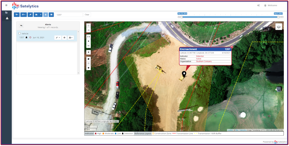
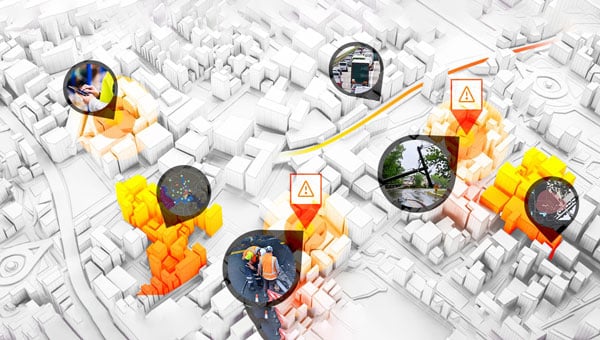
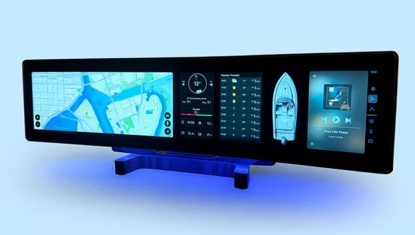
      GIS is a technology that connects data to a map, integrating location and descriptive information. GIS helps users understand patterns, relationships and locational context, and supports decision-making in various industries.

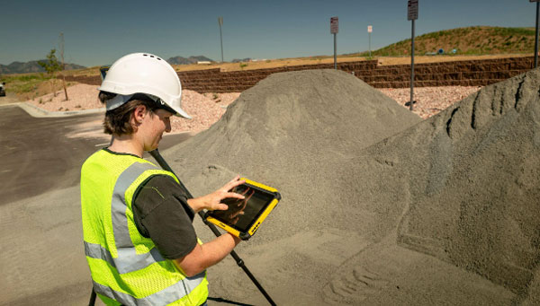
      A real-time GIS can create situational awareness because of its ability to simultaneously ingest, integrate, analyze and display streaming data from most any sensor, device and social media. GIS and location-based analytics can automatically refine and focus real-time data to accomplish the mission with up-to-the-minute intelligence on what’s happening in the field and across agencies and governmental jurisdictions. That’s why police, fire and emergency management organizations at all levels of government use real-time GIS capabilities in their operations and dispatching centers.

      Building Robust New Layers is Key

      As the duration — or reach and impact — of an emergency event increases, so does the number of agencies involved in responding to and mitigating that event. This requires communication systems to scale accordingly, ensuring seamless information exchange and communication among those agencies.

      A significant obstacle to this essential communication is the lack of interoperability, with data interoperability playing a critical role. Data interoperability is the ability of different systems, devices or organizations to share digital information so they can communicate and work together effectively. Without this interoperability, organizations face delays in decision-making, reduced response efficiencies and challenges in coordinating incident management.

      The Cybersecurity and Infrastructure Security Agency published the Information Sharing Framework as an approach to address the data interoperability challenge. It puts forward a three-layer framework that presumes:

      • a data layer, which resides with an individual agency in its nonsharable silo;
      • a presentation layer, which is the end user who needs to see the data in context for real-time situational awareness and decision-making;
      • and sandwiched in between is an integration layer, which does the necessary translation between the data and presentation layers in which the data is discovered, accessed, exchanged, analyzed and transported to the end user. [2]

      For RTSA, the system must be able to access the relevant information in the data layer, to transform and standardize that data such that it can be augmented with other data to create actionable information that can be pushed or pulled into the presentation layer to inform the end user. This information will answer myriad questions about the situation such as when, where, who and what.

      Radio Frequency Real-Time Situational Awareness

      In today’s world of autonomous vehicles and swarms of drones, the electromagnetic spectrum is becoming a critical part of situational awareness. Both in knowing what spectrum is available for use and what spectrum needs to be defended or excluded due to willful interference.

      Even in the context of space, RF spectrum data can help monitor satellite communications and detect anomalies, providing a more comprehensive understanding of the space environment and its potential threats.

      The RF spectrum frequencies range from 3 kilohertz to 3 THz (which spans 3 KHz up to 3 billion KHz). Radio waves, part of the RF spectrum, are regulated by national laws and coordinated by the International Telecommunication Union to prevent interference between different users.

      Radio frequency real-time situational awareness involves the use of radio frequency data and sensors to monitor, analyze and understand this environment. It is crucial for operational planning where the electromagnetic spectrum is a critical domain.

      Its ability to provide real-time awareness of radio frequencies is critical to building an actionable picture of what are very dynamic environments. For example, recognizing the critical nature of an incident as it escalates from a local situation to a regional one.

      Under the Hood

      Effective spectrum monitoring devices rely upon modern developments in software-defined radio (SDR) technology that facilitate rapid reconfiguration and adaptation for various tasks. These include significant enhancements not only to computing capabilities but to the neural processing unit capacity as well. In part, to facilitate RF bandwidth pattern of life technical capability including time frame to gain specific insights.

      Various capabilities are also expected to emerge in the coming years associated with situational awareness that may have a significant impact on the effectiveness, safety and health of especially the first responder community. The internet of things, cameras, data from other applications and networks, and sensors continue to produce increasing amounts of data. Artificial intelligence and data analytics are envisioned to be increasingly important mechanisms to assist in enabling timely and more informed decisions.

      Multipurpose Remote Sensors

      RF devices used for assured positioning, navigation and timing (A-PNT) most naturally are able to provide RF mapping for situational awareness. The same RF spectrum mapping that gives operators the tools to see real and potential frequency interference and usage. Just as GIS helps provide real-time situational awareness in the physical world, spectrum mapping provides RF real-time situational awareness in the virtual world. Different data, different tools, but the same need and general approach.

      Such multipurpose devices could further contribute to helping build RF situational awareness to include information about emitter identification and locations core to RF mapping. Or RF-based sensors could be able to use signals such as those used by tactical radios, once their location is established.

      This fulfills the vision that these RF devices, for example, could be positioned to support RF multiple aspects of situational awareness when not performing their primary mission.

      This requires RF real-time situational awareness to be integrated into operational frameworks to allow for better decision-making, improved safety and enhanced capabilities in both military and civilian applications. By leveraging RF data in multiple ways, organizations can fill gaps in traditional monitoring techniques, leading to a more robust understanding of the operational landscape. RF real-time situational awareness is a critical capability that enhances operational effectiveness using advanced sensing technologies and data analysis, particularly in complex environments.

      Poised for a New Generation

      A key element for the aforementioned presentation layer is to provide the same data to many, although specific locations, referred to as narrowcasting (think narrow multicasting). A new company, EdgeBeam Wireless, is building a next generation broadcast system to provide these services largely referred to as datacasting. Powered by the broadcast industry’s latest ATSC 3.0 standard, this new service will make its datacasting compatible with standard IP networks, fiber networks and mobile 3GPP networks. It could be used for very efficient geolocation delivery of all real-time situational awareness data to many specific locations. [3]

      A good example of an RF-based terrestrial platform is MerlinTPS. This terrestrial positioning system provides 100% terrestrial, RF-based assured positioning, navigation and timing. As part of its operation, the system naturally makes a spectrum map within the radius of each of its reference units. For example, coverage of the entire U.S. would take about 200 reference units, plus about 100 backup units. This RF spectral map is updated with one-second iterations, keeping the data up to date for any unfolding spectral and terrestrial events.

      The MerlinTPS platform is based on modern-day SDR technology, ideal for flexibility of RF spectrum presence, as well as the growing use of AI. This feature then naturally could be used to create and maintain a total spectrum map and pattern of life.

      The platform supports high-precision time transfer of plus or minus 10 ns, critical to A-PNT today, along with positioning and navigation services. The platform can also provide geolocation data for modern real-time GIS features needed for this new generation of real-time situational awareness.

      The combination of MerlinTPS with use of the ATSC 3.0 pending EdgeBeam Wireless service could provide the highly full-featured capabilities to fuel the newest generation of real-time situational awareness networks.


      References

      1. “The Importance of Real-Time Situational Awareness in Public Safety and Transportation,” John Contestabile, Director, Public Safety Solutions,The Importance of Real-Time Situational Awareness in Public Safety and Transportation | Skyline Technology Solutions
      2. “Approach for Developing an Interoperable Information Sharing Framework,” Version 1.7 Publication: August 2021, Cybersecurity and Infrastructure Security Agency  Approach for Developing an Interoperable Information Sharing Framework, version 1.7, August 20212
      3. EdgeBeam Wireless, ( https://www.linkedin.com/company/edgebeam/about/ )
    7. Emlid launches GNSS receiver line to simplify precision positioning

      Emlid launches GNSS receiver line to simplify precision positioning

      Emlid has introduced a new generation of all-band RTK receivers including the Reach RX2, Reach RS4 and Reach RS4 Pro. They are built for surveyors, GIS specialists and construction teams seeking reliable, high-accuracy positioning with consumer-level ease of use. This EU-based developer of high-precision GNSS receivers and software is on a mission to make professional-grade precision simple, fast and scalable.

      The Reach RS4 and RS4 Pro mark a significant step forward from previous Emlid models, combining rugged engineering with faster workflows and uncompromised accuracy. The flagship Reach RS4 Pro introduces innovative camera-vision technology that blends traditional RTK with visual positioning to cut survey time and simplify work in complex environments.

      Image: Emlid
      Image: Emlid

      Both receivers support all-band RTK reception (L1/L2/L5/L6) across every major satellite constellation, ensuring consistent performance even under canopy or in urban canyons. An integrated antenna system with diversity LTE, dual-band Wi-Fi and Bluetooth provides a clean GNSS signal and stable fix, while the Emlid multi-band radio system — up to 2W and interoperable with third-party gear — offers flexible correction transmission at 450MHz and 915MHz for both licensed and licence-free use.

      Further enhancements include next-generation IMU tilt compensation that initializes up to five times faster than before, a durable magnesium alloy body with IP68 protection, and Made for iPhone certification enabling smooth integration with iOS applications such as Esri ArcGIS. A new quick-release survey pole mount ensures fast and accurate setups, even when tilted.

      AR-based stakeout and measurement from images. Building on the RS4 platform, the RS4 Pro adds dual factory-calibrated full-HD cameras that enable augmented reality (AR) stakeout and measurement from images. The AR interface projects geometries directly in the Emlid Flow app, guiding users intuitively to stakeout points. The image-based measurement feature allows for accurate coordinate capture from photos, which is ideal for hard-to-reach places such as facades or active roadways. Together, these vision-based tools streamline fieldwork and reduce reliance on total stations in difficult conditions.

      For users prioritizing mobility, the Reach RX2 delivers professional RTK performance in a compact, plug-and-play format. Like its larger counterparts, it supports all-band RTK signals and features a second-generation IMU tilt compensation system for level-free measurements. A new quick-release mount enables rapid setup in the field.

      Designed for GIS, construction and asset management teams managing multiple projects, the Reach RX2 integrates seamlessly with Esri ArcGIS for data collection and Pix4Dcatch for mobile terrestrial scanning.

      Complete field-to-office workflow. Emlid’s product ecosystem — including the Emlid Flow mobile app and Emlid Flow 360 cloud platform — creates a complete field-to-office workflow for professionals who value simplicity without sacrificing precision. The system enables companies to assign surveying tasks to non-surveyor teams, reducing training requirements while maintaining professional accuracy standards.

    8. Savvy Navvy charts integrated into CPAC Systems’ new product line

      Savvy Navvy charts integrated into CPAC Systems’ new product line

      Marine technology company Savvy Navvy will provide its chart solution to CPAC Systems for integration into CPAC’s Marivue product line, the companies announced.

      The Marivue product line offers infotainment, connectivity and display technology for recreational vehicles and marine applications, including pontoons and watersports vessels.

      “Integrating Savvy Navvy into the Marivue product line strengthens our ecosystem with a proven, user-focused navigation solution,” said Håkan Stigeberg, director of marine segment at CPAC Systems.

      Jelte Liebrand, CEO and founder of Savvy Navvy, said the integration aims to modernize chartplotters through cutting-edge technology. The system allows users to plan routes on their phones and transfer them to onboard displays.

      Savvy Navvy has recorded more than 3 million downloads globally. The application provides routing based on real-time data including departure time, chart information, weather conditions, tides, boat specifications and local regulations.

      The company launched Savvy Integrated less than 12 months ago to integrate its charts and features into built-in boat management systems.