Trimble and the Hilti Group announced today that they are collaborating to deliver new software integration and data exchange solutions. These new integrated solutions provide a connected and improved digital experience for building construction professionals.
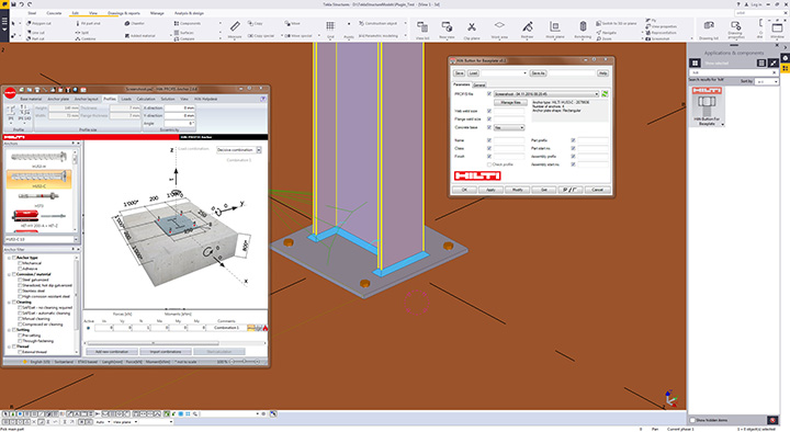
The Hilti PROFIS Plugin for Trimbe’s Tekla Structures.
New software and data exchange solutions include:
Sharing design information between software applications — Hilti PROFIS Plugin for Tekla Structures allows engineers and detailers to apply PROFIS design information directly in a Tekla Structures model through the Trimble Connect collaboration platform.
Easy access to data in the cloud — Hilti’s total stations POS 150/180 and PROFIS Layout Office solutions, and PROFIS detection solutions are now integrated with the Trimble Connect collaboration platform, enabling data to be easily exchanged and shared with others.
More design content, specification information and pricing at a user’s fingertips — Hilti has significantly increased its design content in the Tekla Warehouse to include anchors and cast-in solutions as well as providing more than 7,000 items through Trimble’s TRA-SER and LuckinsLive pricing services.
Since 2010, Trimble and Hilti’s relationship has been built upon shared values that focus on a deep understanding of customer needs and harnessing innovation to develop value-added solutions that increase customer productivity.
Hilti Corporation supplies the worldwide construction industry with technological products, systems, software and services.
Trimble has introduced Catalyst, a software-defined GNSS receiver that works with select Android mobile handhelds, smartphones and tablets. When combined with a small, lightweight, plug-and-play digital antenna and subscription to the Catalyst service, the receiver provides on-demand GNSS, geo-location capabilities to transform consumer devices into high-accuracy mobile data collection systems.
The announcement of the new product, designed for GIS professionals, was made at Trimble Dimensions.
Through smartphone and tablet developments accelerated by the bring your own device (BYOD) to work movement, field workers and consumers increasingly have access to positioning technologies for geospatial data use and collection. The Catalyst software receiver collects data and inspects or manages assets using smart devices. The software-defined GNSS receiver is designed to be integrated into a wide range of applications—providing a dual-frequency, multi-constellation receiver. The mobile device receives dual-frequency signals from the plug-and-play Trimble DA1 digital antenna. The small size and light weight of the antenna makes it possible to store in a car glove box or backpack, available for use on demand. By adding a Trimble Catalyst subscription, users can choose the level of accuracy to suit their application needs from meter level to centimeters.
Trimble calls its Catalyst service Positioning-as-a-Service. It is available on-demand. Users download applications to suit their business needs, purchase the low-cost DA1 digital antenna and subscribe to the level of service required for the application. For GNSS corrections, the solution automatically selects the best available correction service based on the user’s location and subscription level. Corrections powered by Trimble RTX technology and the Trimble VRS Now networks are supported. Trimble RTX corrections can be received either via IP/cellular connection or L-band satellite. The subscription cost is based on usage, allowing users to scale up/down for projects with minimal capital expense.
“The addition of Trimble Catalyst expands our portfolio to address the needs of organizations that have adopted a workplace Bring Your Own Device (BYOD) strategy for their businesses and individuals who periodically need accurate positioning to support various work activities,” said Ron Bisio, vice president of Trimble’s Geospatial Division.
TerraFlex Geospatial Data Collection. The first available application for the Trimble Catalyst service is the Trimble TerraFlex cloud-based mapping and GIS field software, enabling users to achieve up to centimeter-level accuracy. TerraFlex is a scalable cloud-based solution addressing a variety of field requirements including attribute-rich GIS data collection on consumer devices. With an intuitive interface and streamlined toolset for creating custom digital form templates, TerraFlex keeps the data flow standardized and streamlined from the field to the office.
TerraFlex provides a common interface for users across a range of common mobile and smart devices to provide robust, high-accuracy GNSS positioning and detailed asset attribution collection. The Catalyst service for TerraFlex provides a new option for a higher level of accuracy for users’ workflows without the upfront investment of traditional hardware GNSS receivers. It enables scaling up to meet specific project demands and allows a workforce to collect high-accuracy location in conjunction with other work tasks.
Availability. Catalyst service subscriptions and Catalyst DA1 antenna are expected to be available in the first quarter of 2017. In addition, a Software Development Kit (SDK) is expected to be available in the fourth quarter of 2016 for developers who are interested in developing new applications that use the Trimble Catalyst positioning on-demand service. Information and updates.
The Piksi Multi is a multi-band, multi-constellation receiver for the mass market. Autonomous devices require precision navigation, especially those that perform critical functions. The receiver uses real-time kinematics (RTK) technology, providing location solutions 100 times more accurate than traditional GPS. Piksi Multi supports GPS L1/L2 and is hardware-ready for GLONASS G1/G2, BeiDou B1/B2, Galileo E1/E5b, QZSS L1/L2 and SBAS. The Piksi Multi Evaluation Kit also has been upgraded with all-new components. The new kit contains two Piksi Multi GNSS modules, two integrator-friendly evaluation boards, two GNSS survey-grade antennas and two high-performance radios, so that it can deliver reliability and range — well over 10 kilometers — and all of the accessories required for rapid prototyping and integration.
For dedicated time and frequency transfer applications
The Septentrio PolaRX5TR.
The PolaRx5TR has 544 hardware channels and supports all major satellite constellations including GPS, GLONASS, Galileo, BeiDou, QZSS and IRNSS. A calibration circuit is incorporated to measure and compensate for internal delay, removing the need for calibration using external equipment and ensuring measurement latching is always accurately synchronized with the PPS input. The PolaRx5TR is compliant with the new-format CGGTTS version V2E of Consultative Committee for Time and Frequency (CCTF) recommendations. Also included as standard is Septentrio’s Advanced Interference Mitigation (AIM+) technology, giving outstanding interference robustness in difficult radio environments. Up to eight independent logging sessions can be configured logging to either the 16-GB internal memory or to an externally connected device.
The NCS Titan GNSS simulator has up to 256 channels (and 1024 multipath channels) and up to 4 RF outputs per chassis, providing flexibility and outstanding performance . The extra complexity and cost of using multiple signal generators is avoided, improving reliability without compromising on functionality. Its innovative design allows users configure channels for any GNSS signals and allocate those channels to any of the RF outputs fitted. This flexibility enables the same simulator hardware to be used for an extensive range of tests, for all types of GNSS applications. The NCS TITAN GNSS Simulator was developed in cooperation with WORK Microwave GmbH, Germany.
The GSS200D Interference Detection and Analysis solution, developed with Nottingham Scientific Limited, comprises field-based hardware and a secure data server for automatic capture and analysis of GNSS radio-frequency interference. Deployments of GSS200D probes provide users with a thorough understanding of the RF interference environment at sites of interest. Spirent has already detected thousands of disruptive GPS L1 interference events with its global network of GSS100D detectors. By adding support of additional frequencies and constellations, as well as improving the analysis and reporting, the GSS200D responds to the demand of critical infrastructure and civil aviation customers.
For surveyors, contractors, builders and engineers
The Carlson BRx6 is a multi-GNSS, multi-frequency receiver. It has a multi-band 372-channel GNSS receiver, Athena RTK technology and an integrated Atlas L-band receiver. The BRx6 also contains electronic sensors that measure tilt, direction (electronic compass) and acceleration, supporting Carlson SurvCE’s advanced features such as LDL (live digital level or e-bubble), leveling tolerance, auto by level, tilted-pole correction and advanced stakeout features. SurvCE contains sophisticated checks for compass and acceleration anomalies to ensure accuracy. The BRx6 delivers affordable, high-positional accuracy. Manufactured to Carlson’s exacting specifications by Hemisphere GNSS, the BRx6 can be used as a precise base station or lightweight rover. RTK corrections can be received over UHF radio, cell modem, Wi-Fi, Bluetooth or serial connection.
RTK Assist is a subscription-based service that provides users with satellite-delivered correction data to seamlessly continue centimeter-level accuracy during real-time kinematic (RTK) correction outages caused by communication disruptions. Users are able to maintain RTK-level performance for up to 20 minutes, reducing any associated downtime and optimizing solution productivity. The RTK positioning with correction data is delivered directly to the receiver via satellite, allowing for a continuous centimeter-level solution that is globally available 24/7.RTK Assist is best suited for applications where there are potential obstructions, dead spots or baseline limitations that would cause RTK network correction losses for short periods of time.
The POSPac MMS 8 is GNSS-aided inertial post-processing software for georeferencing data collected from cameras, lidars, multi-beam sonars and other sensors on mobile platforms. POSPac MMS 8 uses the Trimble CenterPoint RTX subscription service to deliver these benefits for mobile mapping from land, air, marine and UAV platforms. With an internet connection, users can achieve centimeter-level accuracy within one hour after data collection — there is no need to wait for delivery of public-domain ephemeris data. Users can map inaccessible regions that have no existing Continuously Operation Reference Stations (CORS) without the cost of deploying local base stations. With Trimble’s private network, users can attain consistent and reliable uptime.
TerraGo GeoPDF software suite version 7 offers new features to enable open, cross-platform, cloud and mobile access to advanced maps, engineering drawings, high-resolution imagery and other types of spatial data assets. Version 7 has tools for publishing GeoPDFs, including TerraGo Publisher for ArcGIS, TerraGo Publisher for ArcGIS Server, TerraGo Composer, TerraGo GeoPDF Platform Toolkit, TerraGo Publisher for Raster and TerraGo Toolbar. Features include PubPy, which extends and enhances integration into ArcGIS ArcPy to enable on-demand web services and GIS portals; and OpenGeoPDF, which adds Open Geospatial Consortium GeoPackage to GeoPDF documents to enable GIS-Lite applications using TerraGo Toolbar 7.0. Other features include mobile-workflow support, advanced layer control and remote desktop.
Aeropoints are desgined for for companies across the industrial sector — including mining, construction, quarries and landfills.
AeroPoints are smart ground-control points designed to make it easy to capture survey–accurate mapping using drones. The portable ground-control markers are visible from the air and capable of quickly capturing their own positions down to 2-centimeter absolute accuracy. AeroPoints work with any camera or drone, and integrate seamlessly with Propeller’s cloud–based data platform and processing engine. They’re solar–powered, durable and weather- resistant, and they don’t require any on-site connection. To use AeroPoints, customers simply lay them down, fly their drone, and then pick them up again. They automatically connect to a wireless or mobile hotspot when back in range to upload captured positional data.
The miniVUX-1UAV is a compact miniaturized 360-degree field-of-view lidar sensor weighing 1.6 kilograms. It is developed for the implementation of emerging survey solutions by small UAS, UAV and Remotely Piloted Aircraft Systems (RPAS). The sensor offers multi-target capability and accuracy using echo digitization and online waveform processing for data acquisition. It is capable of 100,000 measurements per second and offers an operating altitude of 100+ meters. Its small size and low weight make it suitable for mounting under limited weight and space conditions, allowing UAV-based acquisition of survey-grade measurement data for agriculture and forestry fieldwork, archaeology and cultural heritage documentation, glacier and snowfield mapping, and landslide monitoring.
Safer Together is designed to reduce the risk of mid-air collision between aircraft and UAVs. Developed by senseFly and the Air Navigation Pro app makers, it is designed to make the skies a safer place by providing general aviation (GA) pilots and drone operators with awareness of each other’s airborne activities, giving them the knowledge they need to take any actions necessary to avoid mid-air incidents around 200–400 feetabove ground level, where most light-weight drones fly. SenseFly added GA functionality to its eMotion flight-planning software, enabling operators to create a special advisory when activating automated drone flights. eMotion transmits the advisory to Air Navigation Pro’s server, which will push the information to all smart devices of connected app users. In turn, senseFly drone operators will be able to view the Air Navigation users’ flights in real time.
The Geo-iNAV 1000 SAASM is a low-cost, rugged SAASM GPS-aided inertial navigation system. It tightly couples a SAASM GPS sensor with a high-stability Quartz micro-electro-mechanical system (MEMS) inertial measurement unit (IMU) to provide a high-performance navigation solution in challenging environments. Features include simple integration, SAASM GPS with path to M-code, internal high-accuracy quartz MEMS IMU, tight-coupling with Geodetics’ Extended Kalman Filter, in-motion dynamic alignment, and RS-232, RS422 and Ethernet (TCP/UDP) interfaces.
The Hover Camera Passport hovers in place to allow users to quickly and easily take photographs. The self-flying camera is aimed at consumers, flying without the restraints of controllers. Once the camera is unfolded and powered on, the passport can take 13-megapixel photos and 4,000-pixel (4K) video using proprietary embedded artificial intelligence technology. The Hover Camera Passport introduces a new design into the flying camera field, with its propellers and motors encased in a strong, light carbon-fiber structure that ensures fingers can’t slip through during normal use. Features include auto-follow with face and body tracking, 360 spin; orbit; and self-positioning using a combination of sonar, its downward viewing camera and artificial intelligence.
The Karma drone, designed to accompany a GoPro camera, features a compact, fits-in-a-small-backpack design and includes an image-stabilization grip that can be handheld or mounted to vehicles, gear and more. Karma is designed to capture smooth, stabilized video during almost any activity. Compact and foldable, the entire system fits into the included backpack that’s so comfortable to wear during any activity, users will forget they’ve got it on. The game-style controller features an integrated touch display, making it easy to fly without the need for a separate phone or tablet. The three-axis camera stabilizer can be removed from the drone and attached to the included Karma Grip for capturing ultra-smooth handheld and gear-mounted footage.
The Epson Moverio BT-300 augmented reality (AR) smart glasses are light, binocular and transparent with an organic light-emitting diode (OLED) display. Combining silicon-based OLED digital display technology and Android OS 5.1, the Moverio BT-300 enables transparent mobile augmented reality (AR) experiences, including while flying drones. With the DJI GO app and the Moverio glasses, drone pilots are able to see clear, transparent first-person views from the drone camera while simultaneously maintaining their line of sight with their aircraft.The DJI GO app works with the DJI Phantom, Inspire and Matrice series flying platforms as well as the Osmo handheld gimbal and camera.
The GPS-713-GGG-N and GPS-713-GGGL-N ATEX-qualified triple-frequency GNSS antennas come with Inmarsat rejection filters. Hazardous environments — those found on oil platforms, tankers and refineries — require compliance with the European 94/9EC ATEX directive. Based on the company’s Pinwheel technology, both antennas maximize performance with multi-constellation reception of L1, L2, L5 GPS; L1, L2, L3 GLONASS; B1, B2 BeiDou; and E1, E5a/b Galileo frequencies, the company said.The GPS-713-GGGL-N also supports L-band from 1525 to 1560 MHz. Customers can use the same antenna for GPS only, or up to quad-constellation applications, resulting in increased flexibility and reduced equipment costs. The two antennas deliver choke-ring-level antenna performance, but without the size and weight. Both provide enhanced Inmarsat interference rejection, which allows tracking of GNSS signals in the presence of high-powered Inmarsat transmitters typically found on marine vessels.
The GV-86 is a high-sensitivity GPS receiver module supporting dead reckoning, which enables positioning in environments where no GNSS signals can be received, such as tunnels, underground car parking and deep urban canyons. The receiver concurrently receives GPS, SBAS and QZSS satellite signals. The dead-reckoning function is realized by integrating the information from a gyro sensor and a velocity sensor. It has fast time to first fix, and highly improved noise tolerance, and a configurable position output update rate up to 10 Hz (10 times per second.)
Geonumerics reported a mapping benchmark achieved in June 2016: operation of a tandem aerial-terrestrial system conceived for simultaneous geodata acquisition in corridor mapping missions.
The mapKITE system tests were carried out at the BCN Drone Center on 2,500 hectares of segregated airspace outside Barcelona. A 2-kilometer rural road served as a testing corridor and was operated successfully around ten times. The testing site was prepared with several ground control points for quality checking.
Kinematic ground control point enables tandem ground-air mapping via sensor orientation and calibration.
Tethering the UAS to the terrestrial vehicle. By means of a real-time navigation system, the terrestrial vehicle generates the basic source information for generating waypoints to be followed by the aerial platform. Schematically, for every terrestrial position, a geometrical shift is applied to keep a particular relative air-ground geometry. A “follow-me” scheme keeps the UAV coordinated as the vehicle moves; the tether is set to maintain a constant relative speed. Additionally, the ground vehicle is observed in most of the aerial images.
Top, left and right: mapKITE aerial images from the corridor flown at the BCN Drone Center (June, 2016); bottom: 3D model extracted from aerial images only.
Linking the two with an optical target. An optical coded target on the roof of the ground vehicle is automatically identified and measured in the aerial images in a fast and robust manner. Its goal is twofold: firstly, it enables a complementary guidance scheme based on target-tracking, adding robustness to the virtual tether. Secondly, the image measurement of the optical target together with the high-quality trajectory of the ground vehicle introduces a kinematic ground control for a posteriori sensor orientation and calibration.
By performing photogrametric pointing-and-scaling measurements of the optical target, and linking these with the precise terrestrial vehicle trajectory by means of image synchronization in a common time reference, mapKITE introduces an analogy to the conventional ground control points (GCPs) ready-to-use kinematic ground control points (KGCPs) for every image.
Equipment used in the first mapKITE campaign
Fundamental mission parameters
Aerial camera
Sony NEX-5 (c=20mm)
Gruond Sampling Distance
2,4 cm
GNSS receiver (UA)
Javad TRE-3
Flying altitude
100 m
TV navigation system
Applanix POS-LV420
Forward image overlap
80%
TMM system
Optech Lynx
Image footprint
120 m across-track
More information can be found in the following material:
• download the PDF mapKITE brochure with more information about the test campaign.
• The video of the mapKITE test campaign explains the system and the performance test.
GeoNumerics is a research and development company specializing in geomatics and accurate navigation, located in Catalonia, Spain. The company licenses software and provides R&D services focused on applications of unmanned aircraft, Galileo satellite navigation and inertial navigation in remote sensing and mapping.
Point cloud obtained with the terrestrial mobile mapping system.
MapKITE is currently being developed by an international consortium within the frame of the project “mapKITE: EGNOS-GPS/GALILEO-based high-resolution terrestrial-aerial sensing system“. The project is funded by the European Commission (EC) through the European Union (EU) “Horizon 2020 Programme for Research and Innovation,” supervised by the GSA on behalf of the EC, and coordinated by GeoNumerics. The mapKITE consortium includes ten organizations from five European countries and Brazil.
Drone-maker DJI has partnered with UAV software company Propeller Aero to launch an integrated solution to reduce costs, improve safety and drive operational efficiency in the construction and mining industries.
The partnership integrates DJI’s commercial-grade aerial platform, the Matrice 100, with Propeller’s cloud-based software specifically designed for surveying and inspection.
The solution provides enterprises and commercial UAV operators a simplified, quick and efficient way to automate operations and access data. It will enable businesses to accurately perform site measurements and volumetrics and share data seamlessly with just a few clicks, the companies said.
Rory San Miguel (left) and Francis Vierboom, co-founders and CEOs of Propeller Aero, display the new Aeropoints product. (Photo: Propeller Aero)
Sydney Start-Up. Propeller Aero was founded in 2013 in Sydney, Australia, when Rory San Miguel and Francis Vierboom first got hooked on drone technology. They wanted to bring drones to industries like mining and construction, where they thought the technology was really going to “grow up.”
They set about joining Australia’s regulated drone industry by applying for their drone pilot licenses. While waiting for the paperwork, they created an online app to share data from their trial flights.
Figuring out the best ways to process, visualize and use UAV data ended up being more exciting to San Miguel and Vierboom than actually flying the drone.
Propeller Aero provides cloud-based software that streamlines data processing and simplifies the way data is used and shared. The software package provides web-based geospatial data processing, analytics and instant volumetric calculations for a range of professional applications. It has been adopted by commercial drone operators and enterprise clients in 60 countries.
Deploying UAVs for surveying and inspection can reduce costs, minimize workplace hazards and improve operations, especially for businesses that operate in quarries, construction sites and asset infrastructure.
“Being from Australia, Propeller Aero has had the considerable advantage of developing alongside the industries that have been using commercial UAVs since 2002,” said Michael Perry, DJI’s director of strategic partnerships.
DJI’s Matrice 100. The Matrice 100 platform has DJI’s technology built in, including GPS, the flight controller, the propulsion system, DJI Lightbridge, a dedicated remote controller and a rechargeable battery. The system automatically manages complex tasks required for flight.
Aeropoints are desgined for for companies across the industrial sector — including mining, construction, quarries and landfills.
Propeller Aero has introduced AeroPoints — smart ground-control points designed to make it easy to capture surveyaccurate mapping using drones.
The patent-pending technology provides a simple solution to a major roadblock to widespread commercial drone adoption: accuracy.
Typical ground control requires establishing precise geolocation position using surveying equipment, and then securing a visible ground marker exactly on the pre-marked GPS point.
AeroPoints are portable ground-control markers, visible from the air and capable of quickly capturing their own positions down to 2-centimeter absolute accuracy.
AeroPoints work with any camera or drone, and integrate seamlessly with Propeller’s cloud-based data platform and processing engine (see above story). They’re solar-powered, durable and weather resistant, and they don’t require any onsite connection.
To use AeroPoints, customers simply lay them down, fly their drone, and then pick them up again. They automatically connect to a wireless or mobile hotspot when back in range to upload captured positional data — and precision georeferencing is done.
Applanix introduced at Intergeo 2016 the POSPac MMS 8, its latest GNSS-aided inertial post-processing software for georeferencing data collected from cameras, lidars, multi-beam sonars and other sensors on mobile platforms.
POSPac MMS 8 uses the Trimble CenterPoint RTX subscription service to deliver these benefits for mobile mapping from land, air, marine and UAV platforms:
Achieve centimeter-level accuracy within one hour after data collection with just an internet connection — no need to wait for delivery of public-domain ephemeris data, providing productivity gains
Map inaccessible regions that have no existing Continuously Operation Reference Stations (CORS) without the cost of deploying local base stations
Attain consistent and reliable uptime using Trimble’s private network
Automatically survey in dedicated base stations direct from POSPac – streamline map production workflow
POSPac MMS 8 also includes several new features to make deployment simpler and more efficient:
Avoid rework using the “know before you go” Quality Control software– POSPac 8 now includes a separate QC software that can be commuted to the field for running Quality Control on the GNSS observations to ensure accuracy specifications can be met before leaving the project area
Single floating software license provides increased flexibility by setting up any computer to act as a server, share a single license across a network or between computers
Faster throughput with 64-bit processing
POSPac MMS 8 is expected to be available worldwide in the fourth quarter of 2016.
TerraGo demonstrated at Intergeo the latest capabilities of its line of GeoPDF products as well as survey-grade, mobile GPS and GIS data collection with its TerraGo Edge and TerraGo Magic platforms geospatial collaboration and mobility software.
GeoPDF products enable free, lightweight GIS applications, helping organizations get more value from their current investments in GIS and imagery platforms.
TerraGo Edge and TerraGo Magic are GPS data collection devices combining high-accuracy, survey-grade GPS with advanced mapping and mobile collaboration on Android and iOS devices. With TerraGo Magic, customers and partners can build their own mobile apps, fully customized with their branding and features, without coding.
TerraGo Edge v3.9.6 includes sample code for all REST API end points, automated note name options, enhanced cloud-based publishing of maps and forms and high-volume imagery and map to mobile processing. It includes:
New tools to support ArcGIS and enterprise integration: ArcGIS and enterprise integration using the TerraGo Edge REST API with the addition of sample code for every Edge REST endpoint via Postman API utility.
Automated note names with custom form fields: Configure the one-click QuickNote in any notebook to name notes by a specific form field, enabling speed in the field and user-friendly data management and searching.
Attach maps and forms to multiple notebooks simultaneously.
Import multiple GeoPDFs and GeoTIFFs at the same time: Select or drag & drop many GeoPDFs/GeoTIFFs at the same time for user-friendly, high-volume parallel processing of aerial imagery or offline basemaps.
New media filenames to help associate media to projects, includingnotebook name, note name, and a time and date stamp, to identify, search and sort media files.
GeoPDF. The latest Version 7 of TerraGo GeoPDF includes tools for publishing GeoPDF, including TerraGo Publisher for ArcGIS, TerraGo Publisher for ArcGIS Server, TerraGo Composer, TerraGo GeoPDF Platform Toolkit, TerraGo Publisher for Raster and TerraGo Toolbar.
Features in this release include:
PubPy: Extends and enhances integration into ArcGIS ArcPy to enable on-demand web services and GIS portals.
OpenGeoPDF: Adds Open Geospatial Consortium (OGC) GeoPackage to GeoPDF documents to enable GIS-Lite applications using TerraGo Toolbar Version 7.0.
Mobile: Extends and enhances its support of TerraGo Edge and private-label apps created from TerraGo Magic with capabilities to create notebooks, maps, and applications for mobile workflows.
Advanced Layer Control: Implements of a number of features to improve flexibility and ease of use in production contexts.
Remote Desktop: Enables end users to access TerraGo Publisher and TerraGo Composer on their desktop from remote location.
Compatibility: Supports the latest versions of ArcGIS including the recently released ArcGIS 10.4.1.
Licensing: Implements a new license management system to reduce the complexity and burden of license management, especially in enterprise software management.
SenseFly introduced the eBee Plus, its newest fixed-wing system for survey-grade photogrammetric mapping, at Intergeo 2016.
senseFly eBee Plus S.O.D.A. results
For photogrammetric-quality mapping, upgradeable RTK/PPK functionality and flight time of almost an hour, the UAV is designed for professionals working in fields such as surveying, construction and GIS who require efficient data collection with survey-grade accuracy.
The eBee Plus offers
built-in RTK/PPK functionality, activated immediately or later on demand, for survey-grade accuracy that the operator controls;
the new senseFly S.O.D.A. RGB camera developed specifically for drone photogrammetry work, featuring a 1-inch sensor and global shutter, capable of capturing images with a spatial resolution of 2.9 centimeters.
eMotion 3 flight and data management software, featuring a full 3D flight environment, mission block flight planning, cloud connectivity and free updates.
High Precision on Demand (HPoD) describes the drone’s built-in upgrade path to real-time and post-processing correction (RTK/PPK) functionality. Once activated by the user, this paid enhancement boosts the system’s achievable horizontal/vertical absolute accuracy to 3 centimeters/5 centimeters without the need for ground control points—dramatically reducing expensive, time-consuming field work.
Last year at InterGeo 2015, UAVs ruled, for at least the second year in a row, although some of its newest-thing gloss seemed to be wearing off. This year, sensor integration in both hardware and software is a dominant theme — and one with broader implications and applications.
GNSS positioning technology, aided in many cases by laser scanning, other imaging sensors, total stations, Lidar and camera systems, all collaborating as inputs to mobile mapping systems or machine-control systems, together form a durable platform for many present and future applications.
NavCom booth at InterGeo.
Among the GPS/GNSS companies exhibiting here: CHC Navigation, ComNav Technology, Eos Positioning Systems, Hemisphere GNSS, Navcom Technology, NovAtel, Septentrio, and Tallysman.
“I think it’s a must for every surveyor to participate and get updated with all the developments,” said Chryssy Potsiou, president of the International Federation of Surveyors (FIG), “to try to make the best combination of tools and software so that we can have the best output, in order to provide reliable services at affordable prices, in short time. The world needs solutions, cheap and fast.”
Smart Cities. Along with the roar of the four connected exhibition halls where many new products are being rolled out on this premier world stage, there is a lot of talk — a lot of talk — in the presentation auditoriums about vision, and smart cities, and connectedness in it many forms, electronic and otherwise.
The international trade fair for geodesy, geoinformation and land management, InterGeo can be overwhelming, with roughly 550 exhibits from 33 countries, and 16,000 visitors from 92 countries. It spans everything from surveying, geoinformation, remote sensing and photogrammetry to complementary solutions and technologies, processing, using and analyzing geodata over the Internet and exploring new applications and solutions — it’s all here. Themes include mobility, energy supply, climate protection, and liveable cities and rural areas. Citizen involvement, data protection, data security and e-government all play a key role in future developments. This year, the conference published a pre-show report on geodata and what it calls Business World 4.0.
Host city Hamburg, an economically strong, vibrant city and one of the top three shipping ports in Europe, embraced digital strategy at an early stage. Sustainable city planning, climate protection, an intelligent mobility concept and IT-controlled port management are all aspects of the city that could not work without geodata.
Making Connections. “Our [geospatial] industry is now more and more related, more and more embedded with many other disciplines,” said Nigel Clifford, CEO of Ordnance Survey UK, who gave one of the conference keynotes. “One of the key questions we are facing is: What skills will the workforce of the future need to have, in order to flourish in this interconnected world?
“Some of the more obvious ones are digital capability, looking at data sciences. Also we spoke about some of the softer skills: the ability to look across disciplines, the ability to work with different functions, and really importantly, the ability for our industry to explain its value and be part of the decision-making which is going on around us all the time.
“We’re beginning to see the first fruits of the Internet of Things. There may be some inflated expectations at this point. It’s our job to test that. I’m confident there are some brilliant use cases developing over the next five years in the fields of health, transport, and community engagement. Making a city more efficient, more livable, more secure, and more business-friendly, to draw tax dollars into the equation. What we’re able to do today is so much more data-rich, so much more connected, than we’ve ever been able to do before. ”
He cited pilot public-private partnership projects in Manchester and another unnamed UK city going forward in this regard, with involvement from Cisco, Siemens, and British Telecomm along with Ordnance Survey. “It’s a mixed economy coming together, because there isn’t one answer.”
Looking into the future, he said “Developing nations in particular require a fundamental geospatial fabric in order to boost themselves. I hope there will be a broadening of the focus from what we can do absolutely at the cutting edge of technology with reasonably affluent societies, to thinking about how we can take that into the less affluent societies, and raise all boats through the efforts of this great industry.”
Gorillas Enter Room. Intel has taken a stake in the commercial drone space with its new Falcon UAV. “Predominantly, we are looking at inspections, construction, agriculture, as well as 3D modeling.” The company was joined by Oracle and Autodesk as first-time exhibitors at the show, and they did not enter timidly; big stands.
UAV über Deutschland. In moves shadowing those in the United States, the German Minister for Transport spoke about introducing regulations to govern civil and commercial use of UAVs. The newly published draft foresees the introduction of mandatory registration for unmanned aerial systems. Pilots will need a valid license to fly drones above 100 meters.
Hexagon’s technologies span the geospatial information life cycle from data capture to information delivery. Its portfolio includes land and airborne sensors as well as GNSS receivers, complemented by software applications for data processing, interpretation and analysis. These tools not only display the world as it is, but model the world as it will be.
The company is making a range of presentations at Intergeo 2016, held Oct. 11-13 in Hamburg, Germany. Hexagon is focusing on delivery of geospatial information to facilitate mission- and business-critical decision making.
On the opening day of Intergeo 2016, Cathy Hayes — director of Building Information Modeling (BIM) technology for architecture, engineering and construction (AEC) at Intergraph — spoke on the company’s Smart Build program.
While construction companies have accelerated adoption of information technologies to help manage the complexity of multi-year planning efforts for million- and billion-dollar projects, many of these efforts have proven to be costly, complicated and more disruptive than helpful.
Smart Build is an application for the construction industry to improve profit margins and help complete projects safely, on time and on budget. Hayes presented background and case study material from some of the world’s largest and most challenging industrial projects.
432 Park Avenue, New York
Recent major construction projects involving Hexagon-owned Leica have included using GPS for high-accuracy monitoring and alignment of the 432 Park building in New York (tallest residential structure in the City), a similar project on the Lotte World Tower, a super-tall skyscraper in Korea, and using GPS to align the Gerald Desmond Bridge in Long Beach.
Other Hexagon presentations at Intergeo include:
GNSS and the Value of More Satellite Systems
The rapid evolution of the current and future state of GNSS and how it will affect the geospatial industry.
Digital Realities for Infrastructures
Mobile mapping is supporting the reality capture of critical infrastructures above and below ground for better city management.
IGNITE Your M.App Experience
A new approach to solving business-critical problems. Harnessing the power of the cloud and a community of developers, we can create a better map (and M.App) experience.
Airborne Urban Mapping Made Easy
Best practices for 3D city modeling with the new Leica CityMapper.
Digital Reality Management
Updates on the latest point cloud software.
Centralizing All Monitoring Information to a Single Server for Fast Decisions
Leica’s GeoMoS platforms.
Eos Positioning Systems has announced its most advanced high-accuracy Bluetooth GNSS receiver, the Arrow Gold. The Arrow Gold is the first high-accuracy iOS, Android and Windows Bluetooth GNSS receiver to implement all four constellations (GPS, GLONASS, Galileo, BeiDou), three frequencies (L1, L2, L5) and satellite-assisted RTK.
The Arrow Gold provides 1-cm real-time accuracy in more places, and on all iOS, Android, and Windows devices. The palm-sized Arrow Gold works with any data-collection app designed for iOS, Android or Windows, which means that apps like Esri Collector, Esri ArcPad, Survey123 and others work with Arrow Gold right out of the box.
The Arrow Gold introduces an innovative RTK feature for poor cellphone coverage areas — SafeRTK. The SafeRTK feature uses satellite corrections to fill in when the user’s RTK network connection is lost. Even in populated urban areas, wireless connectivity has dead spots. For traditional RTK receivers, this is a deal-breaker. For the Arrow Gold, SafeRTK takes over when wireless coverage fails, allowing users to continue working with centimeter accuracy for up to 20 minutes, free of charge.
Another pioneering feature of the Arrow Gold is 8-cm real-time accuracy anywhere in the world, at a revolutionary price point. On all iOS, Android and Windows devices, the Arrow Gold Basic delivers 8-cm real-time accuracy anywhere in the world using all four satellite constellations and the Atlas satellite correction service.
The Arrow Gold is built for tough environments. It is palm-sized, waterproof, dust-proof and weighs under one pound. It works in the rain, dust, dirt and in rugged environments. The user can mount the Arrow Gold on a range pole or slide it in a vest pocket. The Arrow Gold’s long-range, rock-solid Bluetooth radio stays connected to your mobile device up to 1,000 meters away, and it’s field-replaceable rechargeable battery pack lasts all day.
Owing to its support of all global satellite constellations (GPS, GLONASS, Galileo, BeiDou) and all planned satellite signals, the Arrow Gold will provide cutting-edge, high accuracy for the next decade, providing a return on investment (ROI) that will serve its users for years to come, Eos Positioning said. It doesn’t matter if user decides to switch from iOS to Android to Windows during the same project or years from now, the Arrow Gold has universal Bluetooth compatibility that supports all mobile devices for the forseeable future.
The Arrow Gold is targeted at high-accuracy applications such as GIS, environmental, agriculture, electric/gas/water/telecom utilities, surveying, machine control, and federal/state/local government.