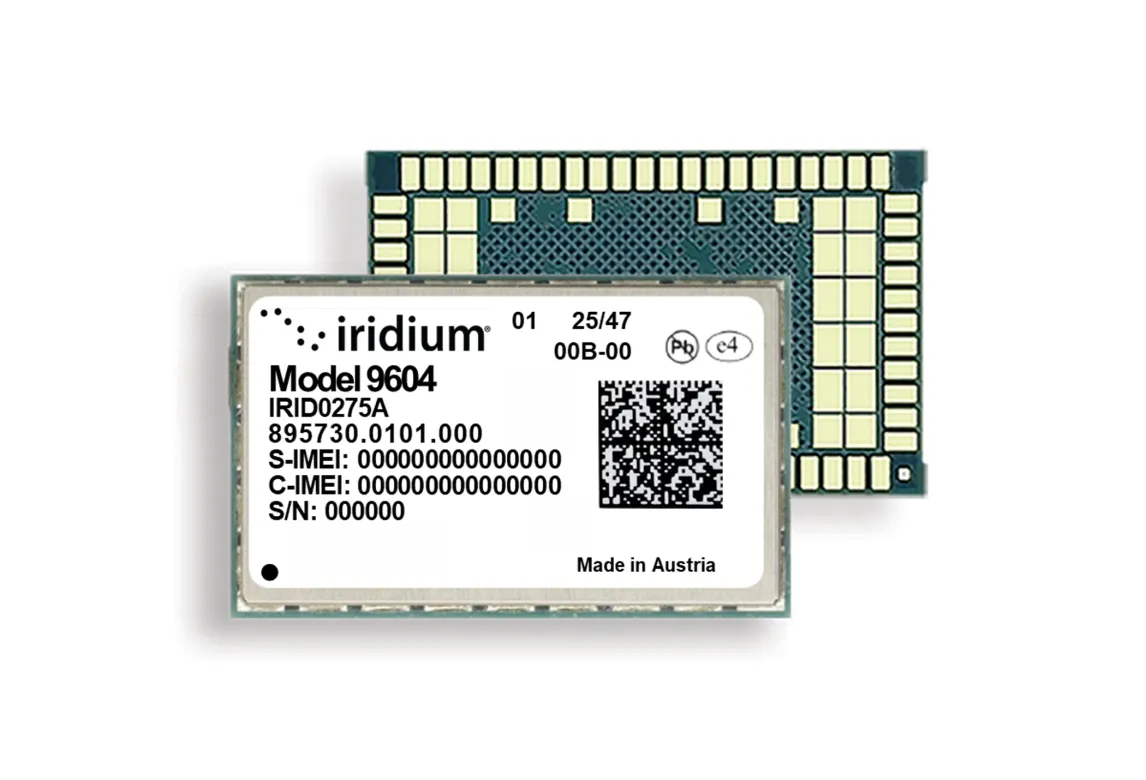
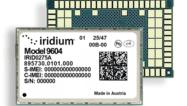
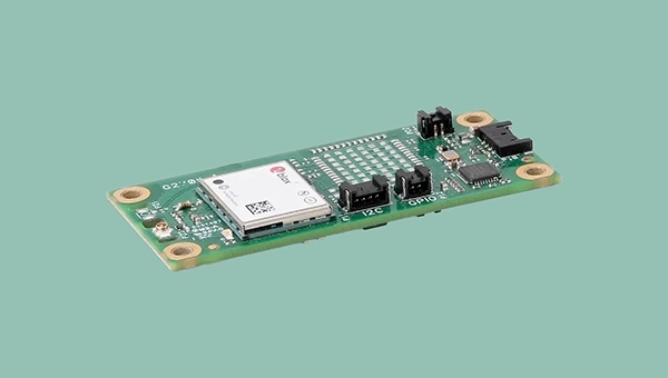
The Iridium 9604 module and development kit streamline global IoT development with integrated satellite, cellular and GNSS connectivity
Iridium Communications has announced commercial availability of the Iridium 9604 module and Development Kit, giving developers, OEMs and solution providers a faster path to build and scale connected IoT solutions worldwide.
Combining GNSS positioning, Iridium short burst data satellite connectivity, and LTE-M cellular, the Iridium 9604 module delivers a compact, integrated solution for global IoT deployments.
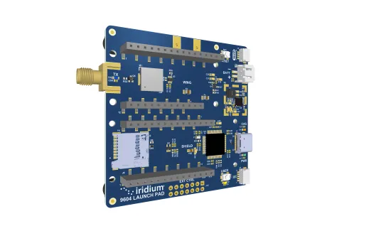
The Iridium 9604 Development Kit, back side. (Credit: Iridium)
Alongside the Iridium 9604 Development Kit, developers can rapidly prototype, test and validate hybrid satellite, cellular, and GNSS applications with resources that simplify integration and streamline deployment workflows.
Built on the u-blox SARA-R5 platform, the Iridium 9604 is designed to reduce hardware complexity, lower integration costs, and accelerate time to market for connected solutions operating across industrial, infrastructure, transportation, mobility, utilities, maritime and remote-monitoring applications. The integrated design helps reduce board space requirements by 60 percent or more while simplifying RF routing, power architecture, and firmware development, Iridium said.
Early developers and beta participants reported significant operational and economic benefits from the platform’s integrated architecture.
“The Iridium 9604 has enabled us to develop a truly global asset tracking solution without relying on terrestrial network infrastructure. Its reliable coverage, compact form factor, and straightforward integration have significantly accelerated our development process and allowed us to focus on optimizing the end-user experience,” said Askar Gabit, CEO, GPSOne. “For applications in remote and challenging environments, the Iridium network provides the confidence that critical data can be delivered when it matters most.”
The Iridium 9604 gives developers independent control over satellite, LTE-M and GNSS subsystems, enabling flexible implementation of failover logic, location-aware connectivity decisions, and application-specific routing strategies. A unified AT command set and comprehensive SDK resources further simplify development and integration.
Built for scalable and power-sensitive IoT applications, the Iridium 9604 features a compact 16 x 26 x 2.4 mm form factor optimized for deployments where size, resiliency and efficiency are critical. The platform supports GPS, GLONASS, Galileo and BeiDou GNSS services alongside LTE-M (Cat-M1) and Iridium’s 100% global L-band satellite network.
The Iridium 9604 represents the next evolution of Iridium’s broader IoT strategy, expanding beyond traditional satellite-only hardware to support unified, multi-mode connectivity architectures. The Iridium network now supports multiple IoT pathways, including dedicated Iridium SBD modules, Iridium NTN Direct standards-based direct-to-device capabilities, and larger payload connectivity through the Iridium Certus 9704 module.
Operating on a global mobile satellite network, the Iridium 9604 delivers reliable connectivity across remote land areas, oceans, airways and polar regions where other networks are unavailable or unreliable.
The QLX3Gx chip makes secure, authenticated positioning a standard feature
Qualinx has integrated support for the Galileo OSNMA (Open Service Navigation Message Authentication) on its QLX3Gx Series ultra-low-power GNSS receiver.
Developed with the support of the European Union Agency for the Space Programme (EUSPA), the integration makes the QLX3Gx a GNSS receiver purpose-built for ultra-low-power markets to deliver hardware-native OSNMA support as a standard feature across the entire product family.
Qualinx has embedded OSNMA support directly into the QLX3Gx hardware architecture from the ground up, enabling a fully optimized design with zero trade-offs in power consumption, cost or performance.
“Authenticated positioning has for too long been out of reach for the devices that need it most,” said Qualinx CEO Tom Trill. “By building OSNMA support into the QLX3Gx at the hardware level from day one, we’re making trusted positioning the default — not a premium option — for the wearables, asset trackers and IoT devices that make up the bulk of the GNSS market.”
The partnership with EUSPA reflects a shared commitment to disseminating Galileo’s advanced security capabilities across the widest possible range of applications and markets. EUSPA identifies OSNMA as a strategic priority for improving resilience against spoofing and signal manipulation
According to the EU Space Market Report 2026, global GNSS revenues are projected to grow from €300 billion in 2024 to €580 billion by 2034 with mass-market devices accounting for the largest share of shipments and representing the greatest growth potential.
Through Qualinx’s digital radio-frequency technology, the QLX3Gx delivers up to 10× lower power consumption than conventional GNSS solutions. By integrating OSNMA natively in hardware, the chip eliminates the processing overhead typically associated with authentication, ensuring security adds no meaningful cost to the power budget.
The chip’s reconfigurable digital RF architecture enables capabilities to be updated over time without hardware replacement — extending device lifecycles, cutting electronic waste, and lowering overall energy consumption. The result is a platform that makes connected devices more secure and sustainable.
The QLX3Gx chip is available for sampling, with mass production planned for the second half of this year. Developers and OEMs can register interest in the Qualinx QLX3Gx Evaluation Kit to secure hands-on evaluation of the QLX3Gx for upcoming consumer, industrial and mobility applications. Contact [email protected] to register interest and request a sample, or learn more at Qualinx.io.
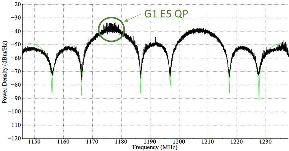
In April, Galileo marked a step forward with the deployment of a new signal component, known as E5a Quasi Pilot, on 12 satellites of Europe’s satellite navigation constellation. This upgrade makes Galileo signals easier to access, particularly on emerging mass-market, low-power devices used for Internet of Things and smart city applications.
With the world’s most precise satellite navigation system, a constellation of more than 30 satellites and five billion of users worldwide, Europe’s Galileo continues to strengthen its position at the forefront of global navigation satellite systems (GNSS).
Galileo signals, like other GNSS signals, traditionally consists of two components: pilot signals and data signals. The first ones are data-less and help enable the receiver to acquire and track the signal, while the second carry all the navigation information needed to pinpoint the target’s location.
But what if this traditional concept could be rethought to respond to emerging market needs, particularly for users seeking faster and simpler acquisition?
The European Space Agency and its industrial partners have developed a solution targeted at mass-market applications that require low power: E5a-QP, a Quasi-Pilot (QP) signal component transmitted in Galileo’s E5 band.
The signal component is broadcast free of charge and now available for implementation in both new and upgraded chipsets, enabling all users of the Galileo Open Service to benefit from its capabilities.
A small addition for a big computational deduction
Quasi-Pilot means a pilot signal that retains its intended role but also carries a small amount of data, including the time information necessary for a first fix. This time information is fully predictable at user level. A Quasi-Pilot signal component is also characterised by a tailored signal structure that simplifies the acquisition process, which reduces the power consumption on the receiver’s end.
This proves particularly useful for low-power, basic receivers such as those found in smartphones, smart-city infrastructure, internet-of-things devices and those that only need to receive a GNSS signal for a very small time to determine their position (also known as ‘snapshot’ devices).
The deployment of E5a-QP also represents a key enabler for low-power receivers designed to process signals exclusively in the E5 band, rather than relying on signals in the E1 band. In this way, the resilience of the receiver against spoofing and jamming attacks is increased, as the fundamental acquisition process is no longer only dependent solely on E1 signals.
Test campaigns have demonstrated that E5a-QP can reduce signal acquisition time by a factor of three, while substantially lowering the number of operations required for acquisition by a factor of eight.
The introduction of this new Galileo signal component follows an extensive series of design, testing and validation that demonstrated the value of the signal and the feasibility of implementing new signal components on current Galileo satellites.
Starting 2020, a design phase explored how to reconfigure the Galileo satellites’ payload to integrate the new signal component. Following on, a series of tests were run on engineering models at ESA’s Navigation Payload Laboratory to demonstrate the feasibility and performance benefits that can be achieved with the new signal component.
In 2023, the solution was then validated using an in-orbit test bench: a duo of Galileo satellites operating in an elliptical orbit reconfigured to transmit the new signal component. The signal was measured at Galileo In-Orbit Test facility at ESEC in Belgium and DLR’s Signal Monitoring Facility in Germany, and successfully acquired and tracked by a set of receivers at ESTEC in the Netherlands.
First generation updated, second generation in mind
Between November 2025 and April 2026, twelve Galileo satellites were updated to accommodate this new signal component, marking the completion of this deployment.
This critical mass of satellites ensures that at least one of the satellites used to compute a position fix transmit the Quasi-Pilot signal at medium to high elevation angles, making sure that users around the world can benefit from the performance gains.
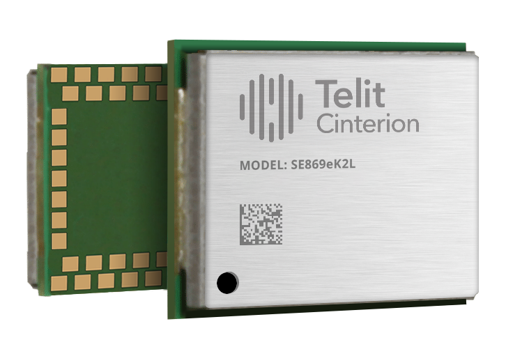
Telit Cinterion has launched the SE869eK2L, a single-frequency L1 GNSS module designed to help device manufacturers upgrade legacy positioning designs with improved performance and cost efficiency, while preserving design continuity.
Built on the Airoha AG3352 platform, the SE869eK2L supports GPS, GLONASS, Galileo, BeiDou and QZSS for reliable multiconstellation positioning. With approximately 1.5-meter accuracy and update rates of up to 10 Hz, it is well-suited for connected devices that require dependable positioning without the cost or complexity of higher-end GNSS architectures.
For OEMs managing product refresh cycles, the SE869eK2L provides a straightforward migration path from Telit Cinterion’s SL869L-V2 and legacy xL869 modules. Its 12.2 x 16 mm footprint maintains pin-to-pin compatibility with the industry-standard form factor, so OEMs can extend existing designs while gaining updated performance and supply flexibility. The footprint includes reserved pins for future use.
The module is designed for a broad range of IoT and industrial use cases, including:
Asset tracking
Fleet management
Smart infrastructure
Cell-tower synchronization
Industrial equipment
Wi-Fi 6E / 7 routers
The SE869eK2L also supports connected devices that require reliable L1 positioning.
Two hardware variants are available: a 3.3 V option and a 1.8 V option, allowing designers to align the module with their system architecture and power requirements.
Dedicated firmware variants provide Windows Location Services compatibility and enable precise timing functionality, delivering synchronization output with ±7 ns jitter.
The module also supports Wi‑Fi navigation mode, enabling compliance with Automated Frequency Coordination (AFC) requirements for Wi‑Fi 6E and Wi‑Fi 7 routers.
Device manufacturers building connected products can pair the SE869eK2L with Telit Cinterion cellular modules — including those without embedded GNSS — simplifying sourcing, integration and support through a single supplier.
Samples of the SE869eK2L are expected to be available soon, with mass production planned for the fourth quarter of 2026.
Telit Cinterion will exhibit at Hardware Pioneers Max, Stand G4, where attendees can learn more about the company’s GNSS, cellular IoT and industrial connectivity portfolio.
Skyfora, a Finnish weather data company building a new global data layer for weather and AI, has raised €6.5 million to transform GNSS telecom infrastructure into a real-time atmospheric sensing network.
The funding comes as demand for high-resolution weather data surges, driven by AI forecasting models, climate volatility, and the growing need for weather-resilient operations.
GNSS metrology system
Traditional weather forecasting relies on sparse networks of expensive ground stations, weather balloons, and radar systems — methods that leave vast gaps in coverage, particularly in urban areas and developing regions. Instead, Skyfora combines atmospheric physics, advanced signal processing, and artificial intelligence to extract weather intelligence from GNSS data.
GNSS meteorology turns every GNSS receiver into a weather sensor. The more receivers in an area, the higher the resolution of atmospheric data achievable.
GNSS signals traveling through the atmosphere are delayed by water vapor. By measuring these delays from multiple satellites and ground stations, Skyfora can create detailed 3D maps of atmospheric moisture — a critical input for weather forecasting.
Once the atmospheric data is captured and reconstructed, the system uses AI and high-performance computing to turn it into accurate, actionable forecasts.
Using existing GNSS receivers
Skyfora’s core technology uses GNSS receivers already installed in telecom networks, complemented by StreamGNSS hardware where telecom GNSS is not available, to measure atmospheric humidity with high precision and frequency. The GNSS signal delays are processed into real-time weather data streams that power next-generation AI weather models and forecasting systems, enabling more accurate, earlier, and hyperlocal predictions.
The company’s approach addresses a structural bottleneck in weather forecasting: most of the world’s atmosphere remains underobserved, and existing observation infrastructure cannot provide the data coverage and resolution required by modern AI models. Skyfora’s solution scales using existing infrastructure, requiring no new hardware at telecom sites.
Skyfora operates active deployments across multiple countries, working with telecom operators, meteorological institutions, forecasting partners and weather-affected industries to build out real-time atmospheric sensing on a global scale.
Latest capital round partners
The new capital will be used to accelerate the commercial scale-up of Skyfora’s software platform and atmospheric data products, expand partnerships with telecom operators, forecasting providers, meteorological institutions and weather-affected industries, and grow the team. The primary focus is on scaling deployment and market adoption: bringing Skyfora’s real-time data, API and atmospheric intelligence dashboard to market.
The round includes equity participation from Eviny Ventures, Ugly Duckling Ventures, Lumo Labs and the European Innovation Council (EIC) Fund, alongside non-dilutive funding from Business Finland.
The company is actively working to deploy datasets and customer opportunities across several countries in Europe, the United States, Africa and the Middle East.
RoGO Communications, the creator of the DropBlock satellite communications platform for cellular-denied environments, is partnering with Augmented Sense Technologies (AugSense) to integrate artificial intelligence capabilities into RoGO’s communications infrastructure.
RoGO was founded to develop lifesaving technology for wildland firefighters and first responders. It’s product DropBlock is a ruggedized, portable satellite communications platform that provides real-time GPS tracking, weather telemetry, IoT sensor data, and tactical messaging in cellular-denied and remote environments.
The partnership will develop edge AI-powered sensor fusion, Team Awareness Kit (TAK) ecosystem development, and predictive analytics to firefighters, disaster recovery, military and other first responders and remote operators, including All Hazards emergencies such as hurricanes, earthquakes and floods. Last month, RoGO and AugSense presented the combined capabilities at the annual convention for Special Operation Forces (SOF Week) in Tampa.
Wildland firefighters, search-and-rescue teams, and military personnel routinely operate in remote terrain where conventional communications infrastructure does not exist. RoGO’s DropBlock technology has proven its ability to deliver real-time GPS tracking, weather data, IoT sensor telemetry, and tactical messaging over satellite links in these environments—deployed today by wildland fire agencies. As missions grow more complex and sensor-rich, operators increasingly need more than raw data. AI can deliver intelligence at the edge, delivered in real time, without dependence on connectivity.
Through this partnership, RoGO will enhance its platform with AugSense’s edge AI engine, a modular, platform-agnostic system that processes and fuses multi-modal sensor data directly on devices, without requiring a cloud connection. The AI-enriched intelligence products will transform raw sensor feeds into actionable decisions, such as predictions for the spread of a wildfire or other threats to safety.
Edge AI Capabilities
Edge AI Processing: AugSense’s engine runs AI workloads directly on edge devices using neuromorphic and spiking neural network architectures, achieving greater energy efficiency than conventional approaches. This means intelligence processing in power-constrained environments — no cloud, no data center, no latency.
Multi-Modal Sensor Fusion: AugSense’s fusion engine synthesizes data from diverse sensors (RF, weather, geospatial, physiological, and chemical/biological) into a single actionable intelligence picture at the edge.
TAK Integration & Development: Purpose-built plugins for the Android Team Awareness Kit (ATAK) and broader TAK ecosystem that overlay AI-fused intelligence onto the common operating picture, enhancing coordination across distributed teams connected through RoGO’s DropBlock network.
Predictive Analytics: Machine learning models that transform raw sensor telemetry into forward-looking predictions such as anticipating weather shifts, equipment failures, threat patterns, and fire behavior.
Immediate Applications
The combined solution targets several high-impact use cases.
In wildland firefighting, the integration enables AI-predicted wind shifts and fire behavior models to reach incident commanders via RoGO’s satellite network—critical for crew safety decisions.
For search-and-rescue operations, fused sensor data and intelligent mapping overlays allow distributed teams to coordinate effectively through the DropBlock network without relying on cellular infrastructure.
In defense and special operations, the partnership delivers fused multi-sensor intelligence and TAK-integrated common operating pictures over satellite backhaul in contested and communications-degraded environments.
A new RoGO mobile phone app coming in the third quarter enables point-to-point communications among DropBlocks and firefighter crews and displays the location of firefighting assets along with fire weather data.
Russian acts targeting critical infrastructure, satellite signal interference paralyzing maritime and air navigation, and cognitive operations aimed at intimidating European societies are examples of Russian hybrid activities targeting the Baltic Sea region states.
The paper, “White Paper on Russian Acts of Sabotage and Subversion against Members of the Council of the Baltic Sea States,” can be downloaded here. Authors Filip Bryjka, Anna Maria Dyner and Aleksandra Kozioł are with the Polish Institute of International Relations.
The report explores GNSS signal disruptions in the Baltic Sea and how it affects the safety of maritime and air traffic.
Scale and Methods of Russian Operations
Since the beginning of the full-scale invasion of Ukraine, Russia has intensified its hybrid activities against NATO member states, particularly those that have most actively supported Ukrainian resistance. This group includes the members of the Council of the Baltic Sea States. It is against them that the vast majority of acts of diversion and sabotage recorded in Europe since February 2022 have been directed.
Russia deploys a full spectrum of tools against the region:
Acts of diversion and sabotage targeting critical infrastructure.
Border incidents: Violations of airspace and maritime borders.
GNSS signal disruptions (satellite radio transmissions), creating operational problems for maritime and air navigation.
Cognitive influence, aimed at causing measurable damage, testing state responses, and inducing a sense of growing threat among societies.
Recommendations: How to Counter Hybrid Threats?
The offensive nature of Russian actions demonstrates an intent to destabilize NATO and EU countries. Effective defense requires developing shared mechanisms:
Close cooperation among agencies: Ensuring a high level of situational awareness through the coordination of activities (at both national and international levels) among military and civilian intelligence, counterintelligence, border guard services, and the police.
A dedicated information exchange system: Leveraging the geographical proximity and potential of the CBSS states to quickly share threat data.
Unambiguous attribution of persuasions: Publicly naming Russia as the author of the attacks. A lack of clear attribution hinders coordinated preventive and retaliatory measures.
A catalog of best practices: Developing common rules for monitoring, reporting, and responding to known and repetitive Russian operational patterns.
The authors conclude that only a full spectrum of coherent measures taken by all states in the region, alongside NATO and EU structures, can effectively influence Russia and reduce the risk of future incidents.
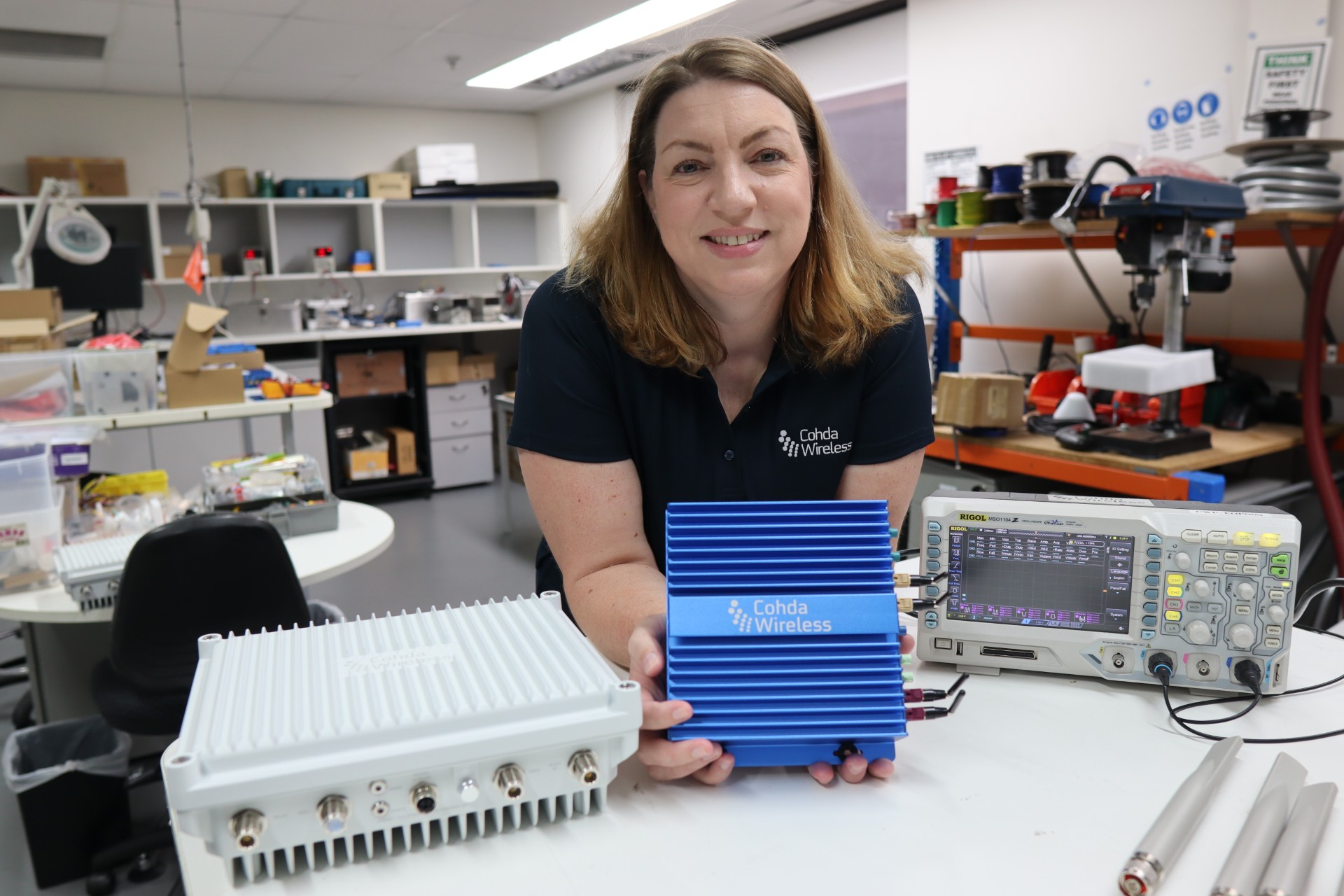
The Maricopa County (Arizona) Department of Transportation (MCDOT) has selected connected-vehicle technology specialist Cohda Wireless to support delivery of its Connected Vehicle Acceleration Zone (CVAZ).
The CVAZ is a USDOT-backed deployment designed to accelerate interoperable vehicle-to-everything (V2X) technology across key corridors in the county. CVAZ forms part of the Federal Highway Administration’s “Saving Lives with Connectivity: Accelerating V2X Deployment” program, which is supporting national models for connected vehicle deployment in Arizona, Texas and Utah.
The Maricopa County project will rely primarily on 5.9 GHz communications and is expected to connect up to 750 physical and virtual roadside units with 400 onboard units across transit, emergency response and freight fleets.
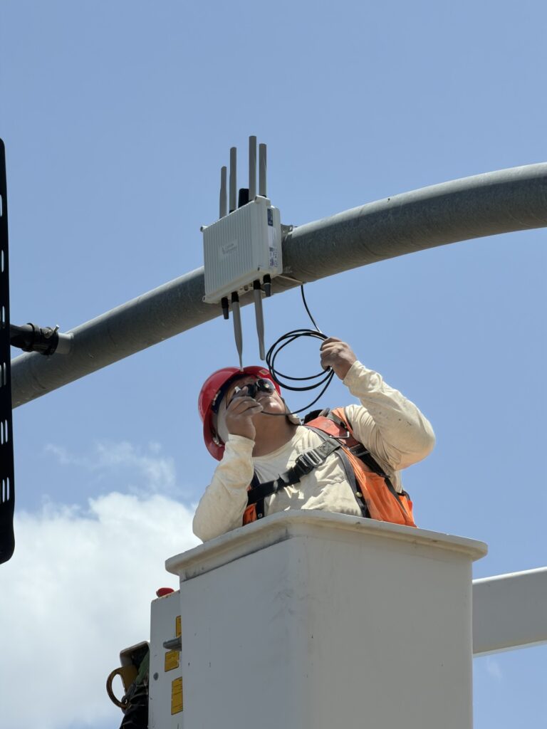
An MK6 Road-Side Unit being mounted to traffic infrastructure. (Credit: Cohda Wireless)
The deployment will support emergency vehicle pre-emption, vulnerable road user alerts, transit signal priority and freight signal priority in Phoenix, Tolleson, Avondale and unincorporated Maricopa County, as well as along ADOT’s US 60 highway.
Together, these applications are intended to help emergency vehicles move more efficiently through intersections, improve transit reliability, reduce freight delays and provide earlier warnings around pedestrians and cyclists.
Following its selection as a vendor, Cohda is contributing technical expertise in testing and deployment planning to support delivery of the CVAZ application zones. Under the project, Cohda will supply MK6 Road-Side Unit (RSU) kits and MK6 On-Board Unit (OBU) kits across the CVAZ application zones.
The program is designed as a multi-vendor deployment. Cohda’s RSU and OBU platforms are positioned to integrate with the county’s selected roadside processing environment, helping reduce integration risk and support faster deployment.
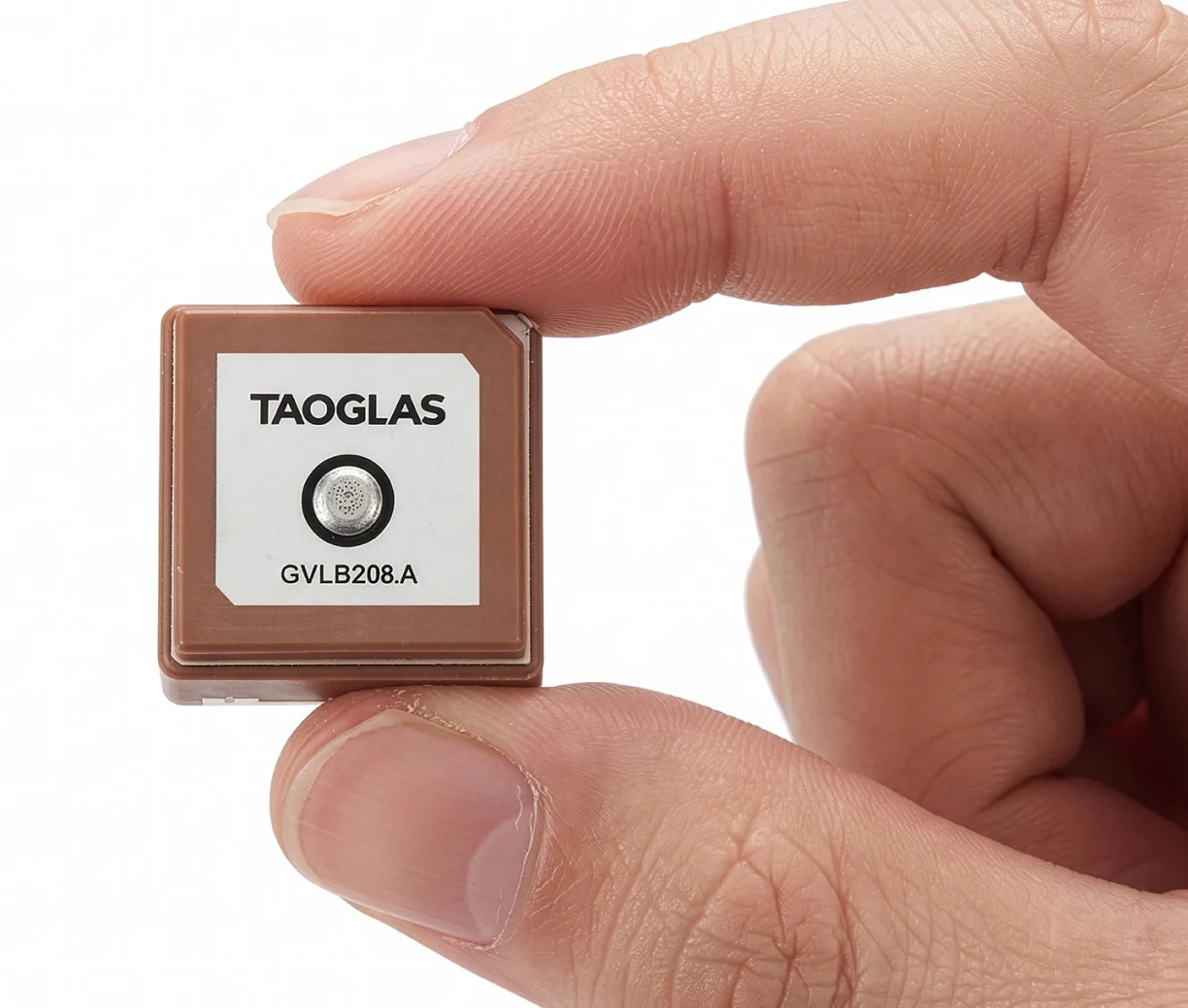
Taoglas has launched the GVLB208 series, an active and passive dual-band GNSS L1/L5 stacked patch antenna — the first in a new family of ultra-compact antennas.
Combining a tiny package with concurrent L1/L5 support and stable right-hand circular polarization (RHCP), the antennas deliver reliable centimeter-level positioning in a compact 20 x 20 x 8 mm footprint.
The GVLB208 series is designed for applications that require high-precision positioning in a compact form factor. Its size, dual-band support and circular polarization make it suitable for designers looking to improve positioning performance without increasing device footprint.
The new antennas address this challenge with a single-feed stacked patch design that supports concurrent L1 and L5 GNSS bands. By leveraging dual-band operation, they significantly reduce the impact of multipath interference, enabling more reliable positioning and improved accuracy in complex RF environments.
The series delivers dual-band L1/L5 performance typically associated with larger GNSS patch antennas. The antenna achieves peak gain of up to 1.5 dBi, approximately 50% efficiency across both bands, and an axial ratio of around 4 dB, supporting stable RHCP signal reception and consistent positioning performance.
Optimized for major global GNSS constellations, including GPS, Galileo, GLONASS and BeiDou, the GVLB208 series supports reliable operation across varied RF environments.
The passive GVLB208 A single-feed architecture enables dual-band L1/L5 performance without the complexity of multi-feed designs, while its pin-mount configuration simplifies RF layout and integration. It can be easily implemented on standard PCB designs, with optimal performance achieved on a typical 70 x 70 mm ground plane.
The active AGVLB208.A, including active electronics and filters, is supplied with 1.13 micro-coax cable and an I-PEX MHF I connector for easy integration with the latest multiband GNSS modules.
The GVLB208 series is suitable for autonomous delivery robots requiring seamless sidewalk navigation and precise drop-offs, where every centimeter counts. It also supports applications including unmanned aerial vehicles (UAVs), telematics systems, fleet and asset tracking, precision agriculture, and industrial IoT deployments.
Taoglas plans to expand the GVLB208 family later this year with an active SMD variant with integrated active electronic components, designed for automated high-volume manufacturing.
Telit Cinterion and Swift Navigation have announced an expanded partnership. Telit Cinterion will offer Swift Navigation’s Skylark Precise Positioning Service as part of an integrated IoT positioning solution.
This service is available with Telit Cinterion’s dual-frequency GNSS modules and NExT cellular connectivity. IoT customers gain one source for the hardware, connectivity and Skylark Dx correction data needed for sub-meter positioning.
What began in 2024 as a technical partnership has grown into a comprehensive joint offering, uniting hardware, connectivity, and corrections into a seamless solution for IoT customers.
Telit Cinterion customers can now buy modules, connectivity and corrections under one contract. For many IoT projects, this cuts vendor coordination and avoids the cost and operational complexity of building or subscribing to an RTK base-station network.
Skylark is available in three variants — Skylark Dx, Cx, and Nx RTK — to meet a broad range of requirements for accuracy, coverage, bandwidth, and power consumption.
All Telit Cinterion dual-frequency L1 + L5 GNSS modules offer native support for Skylark Dx, which streams differential GNSS (DGNSS) corrections directly to the receiver over the cellular network. Skylark Dx runs over standard RTCM via Internet Protocol (NTRIP), using minimal bandwidth and power, and provides country-wide coverage. This makes it practical for IoT devices with limited bandwidth or tight power budgets.
Typical applications include:
e-mobility
fleet and asset tracking
robotics
drones
These are cases that don’t require centimeter-level RTK accuracy but do need reliable sub-meter positioning. Customers requiring higher accuracy can upgrade to Skylark Nx RTK on compatible module variants without redesigning their devices or changing suppliers.
“Customers tell us they want precise positioning without complexity,” said Neset Yalcinkaya, president of IoT hardware at Telit Cinterion. “We’re bundling Skylark Dx with the GNSS modules and cellular connectivity we already ship. This gives customers one supplier and a single integration approach, plus a clear path to RTK down the road.”
“At Swift Navigation, our mission is to make precise positioning a standard capability,” said Holger Ippach, chief operating officer at Swift Navigation. “This partnership advances that vision by embedding Skylark into Telit Cinterion’s GNSS modules and connectivity, giving customers direct access to reliable, sub-meter positioning without the integration overhead traditionally required.”
Service Availability
Skylark Dx is available now with Telit Cinterion solutions in Europe, North America, Japan, South Korea and Taiwan. Coverage will expand as Swift Navigation adds regions.
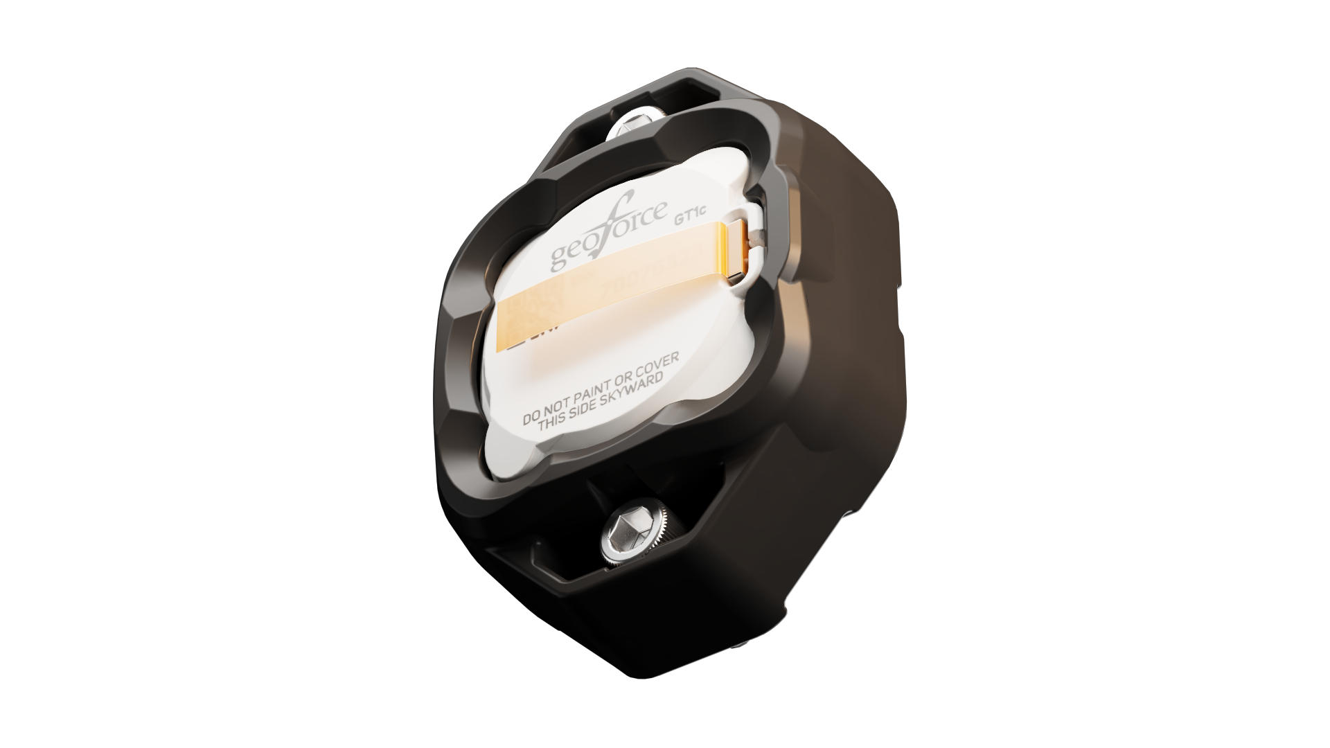
Geoforce has launched the GT1c, which enables rugged cellular equipment tracking at scale. According to Geoforce, the GT1c has a more cost-effective, purpose-built design to complement Geoforce’s full range of satellite tracking devices.
The GT1c operates on AT&T’s network, built for the next era of IoT connectivity for business. The device’s launch builds on a collaboration with AT&T Business announced in March and represents the first product outcome of the relationship.
The GT1c captures and feeds smart location updates to Geoforce’s mobile-enabled asset intelligence platform, providing field operations and asset managers with visibility into the location, movement and utilization of industrial assets and equipment.
The GT1c has an encapsulated design, reinforced bezel, and intrinsic safety certification to ensure that it can survive in hazardous, heavy-vibration environments and extreme temperature ranges. It’s low price means customers can afford to track almost every asset class, the company said.
Pilot programdemonstrates value
In a pilot program with Black Diamond Equipment Rental, the GT1c demonstrated that expanding tracking across mid-tier and small assets is both practical and operationally impactful. The heavy-duty equipment rental company expanded tracked inventory by 26% across smaller and mid-tier construction and oil and gas rental assets. The result was a significant reduction in operational friction and time savings expected to exceed 500 hours per year.
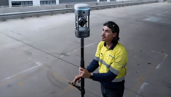
FastXY can transform standard mobile devices into professional-grade data collection tools for geospatial information systems (GIS) and architecture, engineering and construction (AEC) professionals. FastXY offers professionals the ability to collect point, line and polygon data, and delivers advanced capabilities including 3D basemaps, construction staking, topographic surveying, on-the-fly datum transformations and survey-grade elevations. A built-in Bluetooth data parser allows users to configure the app to collect data from virtually any instrument supporting BLE Bluetooth or RS-232 — including echosounders, radiation sensors, laser rangefinders, barcode scanners and more — and marry that data instantly with precise GNSS coordinates. Available in free and premium versions.
Handheld scanner: Designed for BIM, indoor scanning and reality capture
The RS7 handheld SLAM (simultaneous localization and mapping) scanning solution was built for BIM documentation, indoor surveying, renovation planning and complex spatial analysis. It is designed to help professionals capture high-density 3D data efficiently and convert it into practical deliverables through CHCNAV’s software and cloud ecosystem. The RS7 integrates a next-generation lidar scanner capable of measuring up to 1.15 million points per second. Its wide field of view (360° x 189°) supports comprehensive coverage of floors, walls and ceilings, helping reduce the need for repeated passes and complex capture maneuvers in tight or cluttered spaces. The scanner also includes a high-precision inertial measurement unit with bias stability better than 0.5°/h. By combining lidar and inertial data, the system is designed to maintain stable motion estimation and consistent point-cloud quality in environments that challenge many mobile workflows, including long corridors, repetitive structures, and feature-limited interiors.
Mobile scanner: All-in-one system offers SLAM, LIDAR, RTK and 360 degree imagery
The GX1 is an integrated, highly accurate all-in-one mobile scanning system combining simultaneous localization and mapping (SLAM), lidar, real-time kinematic (RTK) georeferencing, cameras and software. It supports a seamless workflow, from capture to deliverable, and can reduce the time required to survey a site by up to 95%. The independently validated global accuracy of 5 mm to 10 mm delivers the precision needed for topographic and road surveying, scan to building information models, construction progress tracking, and more. These capabilities are supported by integrated RTK georeferencing with real-time quality monitoring, four 20MP cameras for 360° panoramic imagery, and a proven SLAM algorithm. The GX1 has four deployment modes — backpack, survey pole, vehicle mount and supported handheld.
Quad-band GNSS rover: With support for Galileo high accuracy service
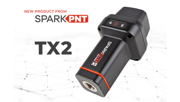
The SparkPNT TX2 quad-band GNSS rover combines an IP67-rated aluminum enclosure with support for Galileo’s High Accuracy Service (HAS) and standard RTK correction workflows. The receiver is built around the Quectel LG290P quad-band GNSS engine and supports multi-constellation tracking. Galileo HAS support provides sub-20 cm accuracy globally without subscription-based correction services, while RTK workflows via NTRIP or u-blox PointPerfect can achieve centimeter-level positioning. Battery life is rated at 50-plus hours, positioning the TX2 for multi-day field campaigns without recharging. The unit connects to iOS and Android devices via Bluetooth and WiFi, with compatibility reported for common GIS and data-collection applications. A notable design choice is the open-source firmware, which gives users visibility into how positioning data is processed and allows for customization and third-party integration. SparkFun has positioned this as an alternative to closed GNSS ecosystems where firmware and processing pipelines are not user-accessible.
Mobile
GNSS platform: Provides ultra-low power GNSS for all environments
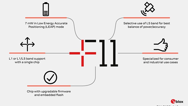
The u-blox F11 platform provides L1/L5 dual-band standardprecision GNSS to improve positioning accuracy while reducing power consumption to as low as 7 mW in typical configurations. It combines ultra-low power operation with intelligent signal management to meet the evolving demands of tracking, wearables, telematics and mobility applications — including micromobility solutions and drones. The platform enables device manufacturers to achieve longer battery life, faster and more reliable position fixes, and greater design flexibility. Its situationally aware GNSS architecture, with integrated geofencing and indoor detections, dynamically balance accuracy and power consumption. By selectively using dual band L1/L5 operation only when it helps maintain positioning performance, the platform reduces energy use while providing resilience and maintaining confidence in location data.
The Iridium 9604 is a compact, threein-one internet of things (IoT) module that integrates Iridium short burst data satellite service, LTE-M cellular connectivity, and GNSS positioning into a single platform. The Iridium 9604 seeks to make dual-mode IoT connectivity viable for price-sensitive, high-volume deployments. Built on the u blox SARA-R5 platform, the module comes in a compact 16 mm x 26 mm x 2.4 mm form factor, suitable for dual-mode IoT deployments across industrial, infrastructure and mobility applications.
L1+L5 GNSS modules: For trackers and high-precision IOT
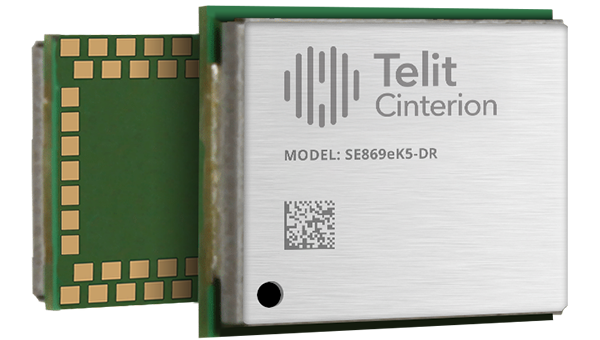
Two dual-band positioning modules built on Airoha’s AG3335 chipset series are available: the ultracompact SE873K5-D and the high-end SE869eK5-DRK. Both support space- and power-constrained IOT devices and use cases that require continuous, ultraprecise positioning. The modules provide a scalable path to adopt dual-band L1 + L5 GNSS.
Timing
Cesium-less clock: An alternative to cesium-accuracy holdover clocks
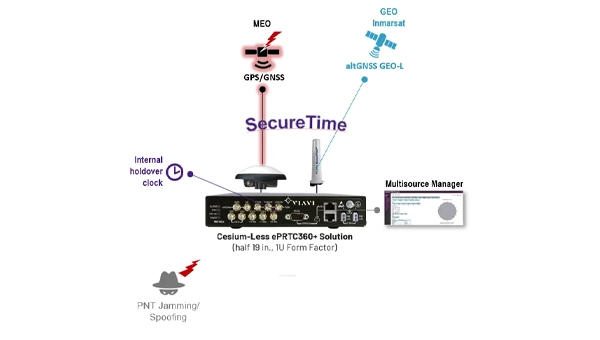
The patent-pending Cesium-less ePRTC360+ holdover solution is designed to safeguard atrisk infrastructure against the increased threat of GNSS timing disruptions. It is the only alternative to Cesium clocks to meet ITU-T G.8272.1 standards. It can protect critical power grids; transportation, aviation and public safety systems; 5G mobile networks; and AI data centers. It meets the international ITU-T G.8272.1 standard and has been successfully tested across a range of livesky defense and commercial jamming/spoofing environments. It has been integrated into VIAVI’s SecurePNT 6200 product series and can maintain 100 ns accuracy during GNSS-denied threats through the resilient altGNSS GEO-L service with no time limit.
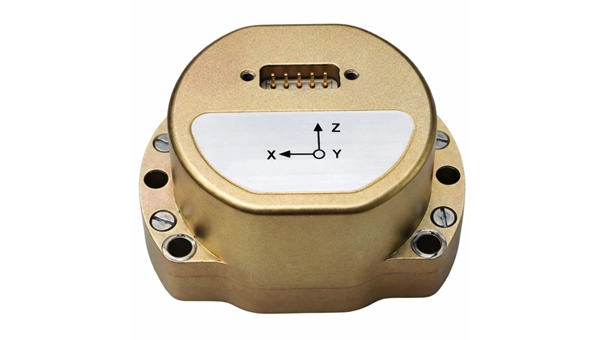
The U4930 series is a reliable and cost-effective six-axis microelectromechanical system (MEMS) and inertial measurement unit (IMU) module for navigation, control and measurement of vehicles, ships and drones. Applications include vehicle/ship attitude measurement, UAV attitude reference and trajectory control, mobile mapping, track inspection and underwater highprecision navigation. The U4930 series integrates high-performance MEMS gyroscopes and accelerometers within an independent structure. The three-axis MEMS gyroscopes sense the angular motion of the carrier, and the three-axis MEMS accelerometers sense the linear acceleration of the carrier. The system internally performs compensation for zero bias, scale factor, non-orthogonal error and acceleration-related terms across all temperature parameters, maintaining high measurement accuracy over a long period of time. The module supports custom communication protocols and provides synchronization for GPS/GNSS time data and pulse per second (PPS) signals.
Underground navigation: For navigating mines and unmapped environments
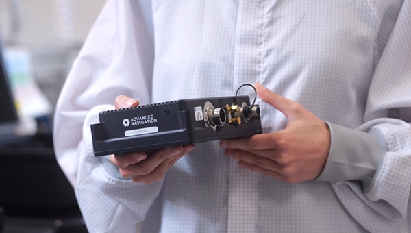
Chimera Land is a 3D laser velocity sensor (LVS) designed to solve the primary challenge for underground mining: maintaining precise vehicle positioning in deep, dark and unmapped environments where GPS cannot reach. When fused with an Advanced Navigation inertial navigation system (INS), Chimera Land allows underground vehicles to maintain stable navigation over extended distances and time. Instead of needing to query an external beacon or satellite for its location, the sensor uses specialized lasers to measure a vehicle’s ground-relative 3D velocity with high accuracy. By feeding this precise data into the vehicle’s INS, the sensor eliminates the drift that typically comes with standalone INS. Using AdNav Intelligence, the result is a resilient, high-performance, infrastructure-light positioning solution that excels in the highdust, zero-light conditions typical of underground mines.
Simulators
GNSS test tool: Provides real-world testing with signals from the field
The SimXTRACT GNSS test tool bridges the gap between field and laboratory. It enables signals captured in field environments to be comprehensively decomposed into individual, discrete signals and applied to lab simulation for realism at every stage of the development test cycle. Developers usually rely on either RF record-and-playback or lab simulation for testing and validation of PNT systems and devices. SimXTRACT takes real signals captured in field environments and performs complex signal decomposition, breaking down each received signal into discrete line-of-sight and multipath ray paths, along with metadata such as Doppler offset, code error, power level and angle of arrival. This decomposed environment is then automatically converted into fully controllable simulation scenarios for Spirent GNSS simulators.
Autonomous
Inertial measurement unit: For unmanned air, land and sea
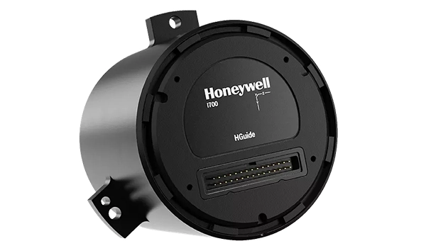
Honeywell launched the HGuide i700, an inertial measurement unit (IMU) that delivers high-accuracy performance for unmanned air, land and sea vehicles. By pairing near navigation-grade capability with a nolicense-required (NLR) classification, the HGuide i700 provides integrators worldwide with a new option for critical sensing and navigation. The HGuide i700 uses high reliability sensors and electronic architecture found in Honeywell’s HG3900 inertial measurement unit (IMU). Compact and low power, the HGuide i700 delivers near-navigationgrade accuracy and reliability while being optimized to support longer range navigation in GNSS-denied environments. The HGuide i700 offers strong GNSS-denied performance for by limiting maximum acceleration and spin rates in a license-free package. The latest in Honeywell’s HGuide suite of no-license inertial solutions, the HGuide i700 allows customers to streamline development cycles, simplify system architecture and transition to field deployment quickly. The HGuide i700’s rugged design, compact size and low-power profile make it suitable for diverse commercial, industrial and defense applications, including autonomous vehicles, mapping and surveying.
Anti-jam antenna system: Provides multi-constellation, multi-frequency GNSS signal protection
The GAJT-AE3 protects all major GNSS constellations from jamming with full multiconstellation, multi-frequency coverage, ensuring reliable PNT in demanding airborne environments. Its antenna electronics mitigate interference by creating up to seven nulls per band in the direction of jammers, providing significant anti-jam protection even in dynamic multi-jammer scenarios. The output is a protected radio frequency signal, free from jamming and suitable for input to modern and legacy GNSS receivers. The GAJT-AE3 protects and supports all GNSS frequencies, including L-band corrections and Iridium PNT.
OEM
GNSS board: All-band multifrequency reception and HAS-ready
Syslogic’s new all-band GNSS expansion board for rugged embedded computers is powered by the u-blox X20 receiver. It supports all major GNSS constellations and frequencies, including L1, L2, L5, L6 and L-band, and enables the use of the Galileo High Accuracy Service (HAS). It provides centimeter-level positioning, opening up new applications across industries such as autonomous field management, operation of construction machinery in remote areas, or navigation of automated guided vehicles and autonomous mobile robots. The GNSS board is designed for worldwide use. The integrated u-blox receiver supports modern correction techniques such as RTK, PPP-RTK and PPP. For the first time, it has been fully optimized for PointPerfect Global, u-blox’s proprietary high-precision GNSS correction service, delivering centimeter-level positioning anywhere in the world. This is particularly useful in remote areas without cellular coverage.
GNSS L1/L5 breakout: For meter-level positioning in embedded applications
The SparkFun GNSS L1/L5 Breakout – NEO-F10N (SMA) is a compact GNSS module designed for meter-level positioning accuracy in embedded applications. It uses dual-frequency L1 and L5 bands, with the L5 signal offering improved performance in urban environments due to reduced RF interference within the protected ARNS spectrum.
The board supports concurrent reception of GPS, Galileo and BeiDou, and uses u blox dual-band multipath mitigation to enhance accuracy in challenging conditions. It features a single UART interface, with an onboard CH340 USB-to-serial converter for easy connection to a computer, and standard pin headers for integration with external systems.
The module includes an SMA connector for secure antenna attachment and is configurable using u-blox u-center software.