Septentrio — a manufacturer of high-end GNSS receivers for demanding professional navigation, positioning and timing applications — is consolidating its sales, service and customer support functions for the Americas in Altus’ facility located in Torrance, California.
“This decision to base Septentrio’s sales and support functions for the Americas with Altus marks the next logical step in our evolving business relationship and professional collaboration with our parent company Septentrio,” said Neil Vancans, president of Altus. “We look forward to leveraging the strengths of both our organizations to grow the market for Altus and Septentrio products across a wide range of market sectors.”
Altus has added industry veteran Mo Kapila as OEM sales manager for Septentrio products. Kapila is based in Altus’ office in Torrance, California. Before joining Altus, he was vice president of sales for Qualinetics, a pioneer in vehicle telematics.
Kapila previously held senior sales management and business development roles at B&B Electronics and Quatech, as well as OEM product management positions at DENSO and Clarion Corporation. He is a graduate from the University of Michigan with a B.S. degree in mechanical engineering.
NovAtel is offering a sneak peak at its Velocity 2014 magazine, which features an informative technical article on precise point positioning, or PPP. The article, “Advanced GNSS Positioning Solutions with Precise Point Positioning,” discusses how NovAtel CORRECT is designed to optimally handle GNSS constellations and corrections to deliver the best possible positioning solution.
The new Velocity magazine is available at the ION GNSS+ conference in NovAtel’s booth, Booth J.
Anyone not able to attend ION GNSS+ will find Velocity 2014 bundled with the next issue of Inside GNSS, or can email NovAtel.
NovAtel is also offering a significant cost savings on the NovAtel CORRECT with TerraStar PPP positioning solution through September 30.
Septentrio and Altus will be presenting their high-performance RTK systems at ION GNSS+ 2014. Attendees are invited to learn more at:
The Triple-frequency Multi-system RTK Engine for Challenging Environments (Session A1 room 18, Wed. 9/10 @11:48)
Gap Bridging in Precise Point Positioning (Session B6 room 19, Fri. 9/12 @3:20)
High-performance RTK provides accurate positioning
in urban environments or under dense canopies
while suffering high ionosphere activities or
when coping with sparse networks
for maintaining a smooth transition during outages
Plus, there is no baseline impact, even at greater than 40 kilometers. Visit booth 318/320 in the Exhibit Hall to learn more about the technology behind the performance.
The year 2014 is most certainly the Year of Galileo.
After rising up from near elimination in 2008 due to much confusion about how to fund it, the European Union, that same year, decided to allocate 3.4 billion euros to fund the ground infrastructure and the initial satellites. Unlike the U.S. GPS and Russian GLONASS systems, Galileo is civilian-funded as opposed to being funded primarily from defense budgets, which makes it politically much more difficult to gain funding. But, they did it.
That was six years ago.
Since then, ground infrastructure has been designed and built. Six test satellites have been designed, built and successfully launched into orbit. In early 2013, the first position fix using only Galileo satellites was achieved. With all the necessary test satellites launched and systems tested, the anticipation of FOC (Full Operational Capability) satellite launches has been high, because it would signal the rapid deployment of the Galileo navigation system that would so complement GPS and so benefit the high-precision GNSS user community.
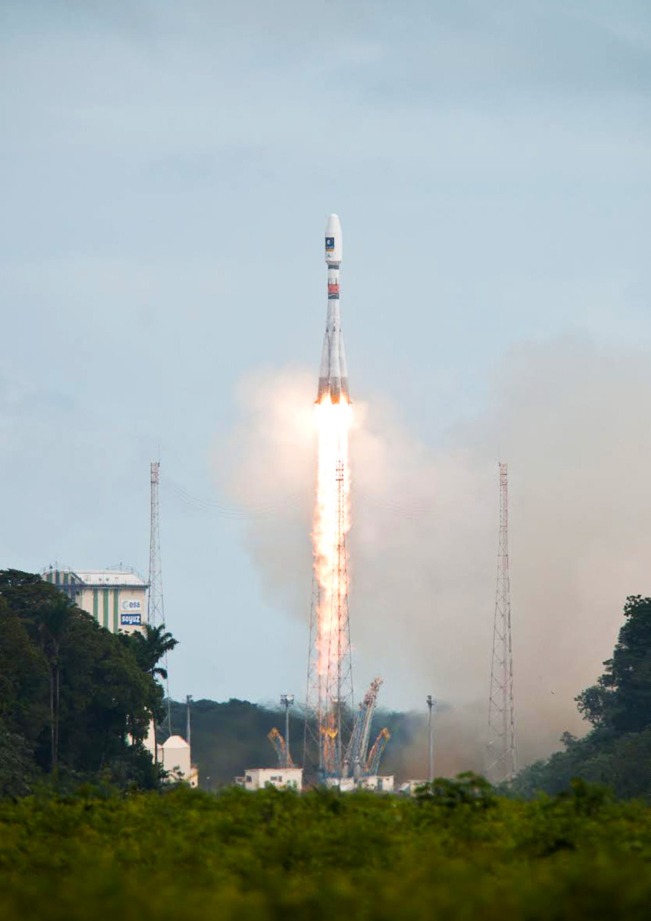
Soyuz Flight VS09, carrying Europe’s fifth and sixth Galileo satellites, lifts off from Europe’s Spaceport in Kourou, French Guiana.
That moment arrived last month, on August 22, with the launch of the first two Galileo FOC satellites. The significance of the first FOC launch is that it would trigger an aggressive launch schedule comprised of one launch every three months, at two satellites per launch — equaling eight satellites launched per year. With four test satellites already in orbit being converted to operational satellites, one can envision 16 Galileo satellites in orbit by the end of next year. While not a complete constellation at that point, it would offer plenty of upside — worldwide I might add, as I’ve written about in the past — by adding more satellites in view and accelerating the adoption of the new L5 signal, which is also supported by GPS.
Between Europe deploying Galileo and China deploying its BDS (BeiDou) system, the world of high-precision GNSS is going to change a lot in the next couple of years. There will be more receiver choices at much lower prices for RTK receivers.
But, the satellite navigation business is not a forgiving one. The devil is in the details, and the number of details has got to be overwhelming. Consequently, there have been many casualties.
The Russians have taken their lumps, losing a total of seven GLONASS satellites to faulty rocket launches in just the past four years.
In 2009, the U.S. placed into orbit a GPS satellite, SVN-49, that never has been set healthy, rendering it a “$100M test satellite.”
Now, the Europeans have joined the club.
The “pucker factor” during the satellite launches is always high, so on August 22, when two Galileo satellites mounted on a Russian Soyuz rocket at the Arianespace launch pad in French Guiana were pushed up into space, there must have been a sigh of relief that the launch seemed to go smoothly. Even I was excited, Tweeting “#Galileo Launch Successful, Satellites Deployed. Booyah!”, shortly after the launch.
However, looks can be deceiving.
It turns out that somehow, some way, the two Galileo satellites, after years of planning, were inserted into the wrong orbits.
The liftoff and first part of the mission proceeded nominally, reports Arianespace, leading to release of the satellites according to the planned timetable, and reception of signals from the satellites. However, the targeted orbit was circular, inclined at 55 degrees with a semi major axis of 29,900 kilometers. The satellites are now in an elliptical orbit, with excentricity of 0.23, a semi major axis of 26,200 km and inclined at 49.8 degrees.
With navigation satellites, we’ve seen disastrous launch failures and defective satellites placed in orbit, but I can’t recall ever hearing about navigation satellites being inserted into the wrong orbits. It’s difficult not wonder how such a seemingly simple error could occur, yet sympathize with the Galileo program managers given the complexity of the task, but also appreciate the consistency and reliability of GPS satellite deployments.
Galileo satellites fastened to upper stage.
The Russians quickly commented on the satellite deployment anomaly since it was a Russian Soyuz rocket launcher, speculating that it was a software bug. The Russian newspaper Izvestia quoted an unnamed source from the Russian Space Agency Roscosmos that “the failure of the European Union’s Galileo satellites to reach their intended orbital position was likely caused by software errors in the Fregat-MT rocket’s upper stage.”
It’s too early to say if the Galileo satellites will ever become serviceable. The Monday following the launch, an independent inquiry commission was formed to “establish the circumstances of the anomaly, to identify the root causes and associated aggravating factors, and make recommendations to correct the identified defect and to allow for a safe return to flight for all Soyuz launches from the Guiana Space Center (CSG).”
This subject will certainly be a hot topic at the Institute of Navigation (ION) GNSS conference being held next week in Tampa, Florida. A full staff of GPS World editors and administration folks will be attending, including yours truly. It’s the premiere GNSS technical event of the year, so I’m sure there will be plenty of scientists and program managers commenting and speculating on the future of these two satellites.
If you’d like the latest news on this and other GNSS-related subjects during the conference next week, follow me on Twitter at https://twitter.com/GPSGIS_Eric. There are lots of interesting subjects at the ION GNSS+ conference. Take a look at the conference agenda here. I’ll be attending many of the presentations related to high-precision GNSS and report to you in next month’s newsletter. To give you a flavor, following are some of the presentations that I’m going to try to attend.
The Triple-frequency Multi-system RTK Engine for Challenging Environments
Mobile Mapping Using Smartphone
Analysis of Using Smartphones for Indoor Mobile Mapping
GPS Program update
Galileo Program Update
Glonass Program update
BDS Program update
GLONASS Only and BeiDou Only RTK Positioning
Comparing Multi-constellation and Multi-frequency Based on GPS/Beidou RTK Positioning
Combined GPS+BDS+Galileo+QZSS for long single-baseline RTK positioning
Real-time PPP with Galileo, Paving the Way to European High Accuracy Positioning
High-Precision GNSS — What will it Look Like in 2020?
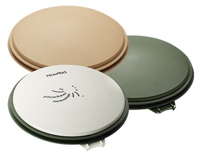
The NovAtel GPS-702-GG-HV high-performance pinwheel antenna comes in three colors. Photo: NovAtel, Inc.
NovAtel, Inc., has introduced the GPS-702-GG-HV to its line of high-performance Pinwheel antennas. Tracking L1/L2 GPS and L1/L2 GLONASS frequencies, customers can use the same antenna for GPS-only or dual constellation applications, reducing equipment costs and need for future redesign, the company said.
With the same form-factor and choke ring performance as the company’s other pinwheel antennas, the GPS-702-GG-HV has been enhanced even further to provide the robustness needed for use under high-vibration conditions.
The phase center of the antenna remains constant as the azimuth and elevation angle of the satellites change. Signal reception is unaffected by the rotation of the antenna or satellite elevation, so placement and installation of the antenna can be completed with ease. With the phase center in the same location for both the L1 and L2 signals and with minimal phase center variation between antennas, this antenna is designed for baselines of any length.
Enclosed in a durable, waterproof housing, the GPS-702-GG-HV comes in three colors: NovAtel standard grey, as well as desert tan and olive drab for military customers. The antenna is available for order beginning September 12.
CartoPac International Inc. has announced a major new release of the CartoPac Mobile Platform. CartoPac 5.0 extends the mobile platform with support for Windows 8 and introduces the CartoPac Workflow Manager, which provides a structured process to manage the use of geospatial data across the enterprise.
CartoPac will demonstrate the applications and technologies of Version 5.0 in the free CartoPac Mobility Webinar Series beginning on September 30.
The CartoPac Platform is a configurable suite of field and office tools designed to maximize the productivity of crews as they digitally map, inventory and inspect critical assets using GPS-enabled mobile devices. Seamlessly integrating with the Esri ArcGIS Server, CartoPac is used extensively by oil and gas companies, pipeline operators, electric utilities, state/local governments and environmental engineering firms to populate the enterprise GIS and asset-management systems with captured infrastructure information.
The new CartoPac Workflow Manager (CWM) in CartoPac 5.0 provides organizations with a structured workflow to view, edit, validate and approve asset data as it moves from the field back into the enterprise. CWM ensures that individuals responsible for data are notified as it comes into the organization so they can incorporate the data into systems related to work-order fulfillment, risk analysis, integrity modeling and other asset management processes.
CartoPac developed CWM for the management of heavily regulated assets in the field, such as gas pipelines and electric distribution infrastructure. A module within the CartoPac Server, the CWM extension creates an audit trail of all the edits and modifications made to the data sets that represent the monitoring and maintenance of real world assets in the field.
“CartoPac Workflow Manager fills the gap between data collection and enterprise asset management systems to enable organizations to maximize the value of their data,” said CartoPac CIO Scott Crouch. “CWM enables organizations to show regulators they have a structured process for tracking and responding to the conditions of their critical assets and has proven to be key component for assisting companies with their regulatory compliance and integrity management programs.”
Further expanding the capabilities of the CartoPac mobile components, version 5.0 has been optimized for the Windows 8 operating system running on standard GPS-enabled laptop computers and tablet devices. This migration means that crews can use CartoPac to collect and manage asset data in the field on the same hardware devices they will use back in the office to run their daily business applications.
“The attractive cost, integration with GPS and expanded performance of Windows 8 tablets and laptops will enable organizations to put more personnel into the field, ensuring that vital infrastructure is mapped, inventoried and properly managed,” said Crouch “Laptop/tablet-equipped maintenance personnel in the field will now be able to run CartoPac solutions on the hardware they already use for tracking repairs and closing work orders.”
To demonstrate the advantages of enterprise asset management, CartoPac has launched the CartoPac Mobility Webinar Series, which will feature applications by electric and gas utilities and highlight new mobile technologies. The first webinar, “Applying New Mobile Technologies to Electric Utility Inspections,” will be presented with EDM International Inc., a Colorado electric utility services company.
The free “Applying New Mobile Technologies to Electric Utility Inspections” webinar will be held on September 30, 2014, at 4:00 pm Eastern Time. To register, click here.
Knowledge-base sections have been created for IGS Working Groups to maintain content for public access. The site administrators ask Working Group chairs to provide updated content to their sections.
Other sections include IGS Real-Time Service, IGS Presents (videos), IGS Multi-GNSS Experiment, news and events.
Because content has been extensively reorganized with this revision, links from many external websites will need to be updated, and the IGS apologizes for any inconvenience.
Topcon Positioning Group has released two unmanned aerial systems (UAS) for mapping — the Sirius Pro and Sirius Basic. Both systems are designed to produce the most accurate solutions for the automated mapping of a wide range of sites — regardless of terrain — including construction sites, mines and quarries, and for use in land surveying, power line and pipeline inspection as well as precision agriculture field mapping.
The fixed-wing systems resulted from a partnership with MAVinci GmbH, a UAS development company with which Topcon recently entered into a worldwide distribution agreement.
“The Sirius Pro system is unique to the UAS marketplace. Instead of using traditional ground control points, Topcon combines RTK (real-time kinematic) GNSS solutions with precision timing technology to provide more accurate mapping results when compared to other products,” said Eduardo Falcon, executive vice president and general manager for the Topcon GeoPositioning Solutions Group.
“The system is easy to use and rugged — allowing operators to use a simple hand launch with precise automatic operation from takeoff to landing, and it can be flown safely in nearly all weather conditions,” Falcon said.
The Topcon Sirius Basic is an entry-level system offering many of the advantages of the Sirius Pro with options to upgrade. “The Sirius Basic shares the same hardware components of the Pro model, providing affordability with the same level of sturdiness and ease of operation,” said Falcon. “Additionally, when the need arises for the increased accuracy and productivity of the Pro system, a simple upgrade makes the transition practically effortless.”
Both systems also offer autopilot assisted manual control, automatic flight planning and safety features.
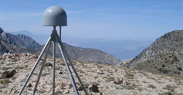
A GPS station in the Inyo Mountains, Calif. Credit: Shawn Lawrence, UNAVCO.
A network of GPS stations in the western United States is revealing the severity of the drought in that region.
Compared to the nine years before the drought, the GPS data show that the western United States has lost 240 gigatons of water, which is enough to flood the entire region in 10 centimeters of water.
Investigating ground positioning data from GPS stations throughout the west, researchers at the Scripps Institution of Oceanography at the University of California, San Diego, found that the water shortage is causing an uplift effect up to 15 millimeters (more than half an inch) in California’s mountains and on average four millimeters (0.15 of an inch) across the west.
Results of the study, which was supported by the U.S. Geological Survey (USGS), appear in the August 21 online edition of the journal Science.
The measurements have a much better resolution — 200-300 kilometers — than data provided by NASA’s GRACE satellites, which shows how the water mass has changed on and below the Earth’s surface.
A dry riverbed in California.
Researchers Adrian Borsa, Duncan Agnew, and Dan Cayan used data from more than 700 GPS stations in the National Science Foundation’s Plate Boundary Observatory to measure the rising and falling of Earth’s surface due to the presence of water. Water in lakes or aquifers weighs down on the Earth causing the surface to sink, while during a drought the surface rises. Each station provides time and position information that is used to calculate the station’s location to within 1-2 millimeters horizontally and 3-5 millimeters vertically.
The current drought began in 2012, when data shows that in general, the ground rose by about four millimeters. The rise in the Sierra Nevada mountain range was 15 millimeters.
While poring through various sets of data of ground positions from highly precise GPS stations within the National Science Foundation’s Plate Boundary Observatory and other networks, Borsa, a Scripps assistant research geophysicist, kept noticing the same pattern over the 2003-2014 period: All of the stations moved upwards in the most recent years, coinciding with the timing of the current drought.
Agnew, a Scripps Oceanography geophysics professor who specializes in studying earthquakes and their impact on shaping the earth’s crust, says the GPS data can only be explained by rapid uplift of the tectonic plate upon which the western U.S. rests (Agnew cautions that the uplift has virtually no effect on the San Andreas fault and therefore does not increase the risk of earthquakes).
For Cayan, a research meteorologist with Scripps and USGS, the results paint a new picture of the dire hydrological state of the west.
“These results quantify the amount of water mass lost in the past few years,” Cayan said. “It also represents a powerful new way to track water resources over a very large landscape. We can home in on the Sierra Nevada mountains and critical California snowpack. These results demonstrate that this technique can be used to study changes in fresh water stocks in other regions around the world, if they have a network of GPS sensors.”
The study was supported by USGS National Earthquake Hazards Reduction Program.
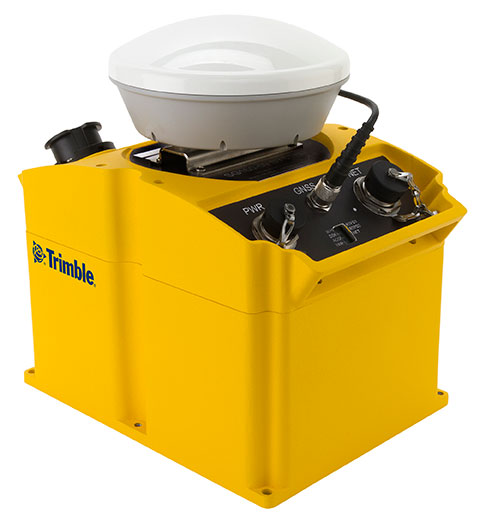
Trimble has introduced an integrated GNSS reference receiver, broadband seismic recorder and a force-balance triaxial accelerometer for infrastructure and precise scientific applications.
The Trimble SG160-09 SeismoGeodetic system provides real-time GNSS positioning and seismic data for earthquake early warning and volcano monitoring as well as infrastructure monitoring for buildings, bridges, dams, as well as other natural and manmade structures.
The Trimble SG160-09 SeismoGeodetic system combines the innovation, reliability and data integrity of both the Trimble and REF TEK brands into a single instrument, Trimble said. The system integrates seismic recording with GNSS geodetic measurement in a single compact, ruggedized package. It includes a low-power, 220-channel GNSS receiver powered by the latest Trimble-precise Maxwell 6 technology and supports tracking of both GPS and GLONASS signals plus the Galileo E1 frequency.
The system includes both the SG160-09 and utilization of Trimble’s CenterPoint RTX correction service, which provides on-board GNSS point positioning. Based on Trimble RTX technology, the service utilizes satellite clock and orbit information delivered over cellular networks or Internet Protocol (IP), allowing cm-level position displacement tracking in real-time anywhere in the world. The SG160-09 system will be available for purchase without the RTX correction service for those applications using real-time kinematic (RTK) positioning.
The seismic recording sensor includes an ANSS Class A, low-noise, force-balance triaxial accelerometer with the latest, low-power, 24-bit A/D converter, which produces high-resolution seismic data. The internally built accelerometer has +/- 4g full scale output, large linear range, high resolution and sensitivity, which makes it ideal for both portable and permanent deployment. The SG160-09 processor acquires and packetizes both seismic and geodetic data and transmits it to system operators using an advanced, error-correction protocol with back-fill capability providing data integrity between the field and the processing center.
The SG160-09 system is ideal for earthquake early warning studies and other hazard mitigation applications, such as volcano monitoring, building, bridge and dam monitoring systems. The SG160-09 system features a variable size industrial grade USB drive to support real-time telemetry data transmission. In the event of a telemetry link outage, the data is stored on the USB drive and can be re-transmitted to the centralized processing station as soon as the communication link comes back up, allowing no data loss during the system operation.
The Trimble SG160-09 system is optimized for field use with instrument mounted or externally mounted GNSS antenna configurations. The lightweight yet rugged SG160-09 consumes very little power and can be used for projects with remote connectivity and in extreme weather conditions. Because the SG160-09 combines both GNSS and strong motion in a single instrument, site installation time is reduced, data communications flow through a single pathway, and station power infrastructure is streamlined, making the SG160-09 a cost competitive solution compared to other systems on the market today. It has an IP67 rating, which means it is sealed against dust and can be submerged in water up to a meter for approximately 30 minutes. The SG160-09 also meets MIL-STD 810F standard for drops, vibration and temperature extremes.
“The SG160-09 is another example of Trimble’s on-going focus in GNSS and seismic technology for the scientific and engineering communities,” said Ulrich Vollath, general manager for Trimble’s Infrastructure Division. “Trimble has developed a combined state-of-the-art GNSS receiver with a high-dynamic range, low-noise accelerometer that provides dynamic monitoring with the flexibility required for today and tomorrow’s challenges.”
The Trimble SG160-09 SeismoGeodetic system is expected to be available in the fourth quarter of 2014.
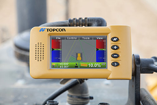
Topcon Positioning Group has announced a multi-platform 3D indicate grade system, the i-33. The new system features GNSS technology and a graphical display designed to provide a powerful indicate system at an economical price.
The i-33 allows for quick installation and easy operation on many types of grading and earth-moving machinery, according to Topcon. It is designed for use on a dozer, scraper or any type of machinery used for cut or fill operations.
“The new system brings the productivity of GNSS-based 3D grade control for all types of applications,” said Kris Maas, Topcon’s manager of machine control product marketing.
“Indicate GNSS systems have not been an economical reality for many contractors or types of work. In other words, the return on investment for a traditional 3D-MC system did not make it practical for bulk earthmoving or less utilized equipment,” Maas said. “With i-33, the game has changed. Its low cost and quick installation make it the perfect solution for use on multiple pieces of equipment or even sharing between machines. Basically, it eliminates over- or under-cutting and ensures material is moved exactly where it needs to be the first time.”
The GX-30 graphical display control box keeps the operator “visually informed as to final grade so adjustments can easily be made, eliminating redundant passes and helping to further reduce the need for onsite grade checking,” Maas said.
The system also includes the new MC-i3 GNSS receiver with Vanguard technology, offering single or dual GNSS antenna configurations, allowing the system to work in a wide variety of applications. The MC-i3 also allows connection to Topcon’s Sitelink3D site management solution that provides real-time data control, machine tracking, reporting and planning in one solution to maintain conformance and improve productivity through all job phases.
JAVAD GNSS is introducing its new unmanned aerial vehicle with the dramatic flourish of a video showing the UAV in flight, accompanied by the “Also Sprach Zarathustra” theme from 2001: A Space Odyssey.
The TRIUMPH-F1 unmanned aerial vehicle is based on the JAVAD GNSS TRIUMPH-1. TRIUMPH-1 is the company’s field-tested high-precision geodetic GNSS receiver with 864 channels to track all current and future GNSS signals.
When used on the ground, the TRIUMPH-F1 can function as a TRIUMPH-1 base or rover. The four motor arms (for eight motors) are detachable. There are four screw inserts in the bottom to attach the TRIUMPH-F1 to a pole mount for field use.