F4Devices, a subsidiary of F4 Tech and strategic partner with BAP Precisions, Taiwan, has introduced a new generation of high-precision GNSS devices for GIS field applications, the Flint rugged handheld. With the new Flint handheld, field workers requiring a rugged mobile handheld device have a unit that is lightweight, compact, rugged, and cost-effective, the company said. The Flint fits well into GIS field data collection markets such as municipalities, oil and gas and forestry, F4Devices said.
The Flint handheld offers a unique, one-of-a-kind combination of flexible GPS configurations, ranging from 1 to 3 meters to sub-meter accuracies, while supporting geotagging with the 5 megapixel autofocus camera as well as Wi-Fi, Bluetooth, and 3G data. There are two versions to choose from, the S812H (includes GPS, Bluetooth, Wi-Fi and 5 MP camera) and the S852H (includes GPS, Bluetooth, Wi-Fi, 5 MP camera and 3G data).
“The new Flint handheld impresses, from the first moment you see it. The ruggedness of the device, IP65, in this small of a package while achieving the GPS accuracies we have been able to achieve is something to acknowledge as a leader in its class,” said Brian Holley, director of Distribution for F4Devices. “Add in its high-resolution, sunlight-readable VGA screen, extendable data storage and Microsoft Office Mobile standard on all units, this makes it even more impressive.”
The Flint handheld is specifically designed for field professionals looking for a rugged, dependable feature-rich device, said F4Devices. The camera button is located as if the user was holding a camera. Combined with the GPS, it provides a powerful solution for precise geotagging. In tough environments, whether it is extreme weather or high multi-path, the Flint handheld is up to the challenge, the company said.
The F4Devices Flint is shock-proof, dust-proof, and waterproof. The battery supports the field users’ needs with at least 10 hours of performance.
F4Devices, along with BAP Precisions, is focused on supporting solutions providers by working with them directly to integrate their applications with the Flint handheld. Any feature or application in the Flint handheld is accessible to software engineers for full and complete integration, allowing a fully developed solution to be offered to their clients, the company said. API’s are available for solutions providers to access and communicate with the features they require.
The 3G data modem in the Flint handheld allows field users to stay in touch remotely, increasing productivity. This also allows real-time communications with the office for critical information upload. This also provides a level of safety for field users by easily staying in touch with supervisors or persons in charge.
Using a large network of GPS stations, a team of researchers has found that the Rio Valley Rift in the Southwest United States — previously suspected to be dead — is slowly expanding, at a rate of about 0.1 millimeter per year.
The Rio Grande Rift extends from Colorado’s central Rocky Mountains to Mexico.
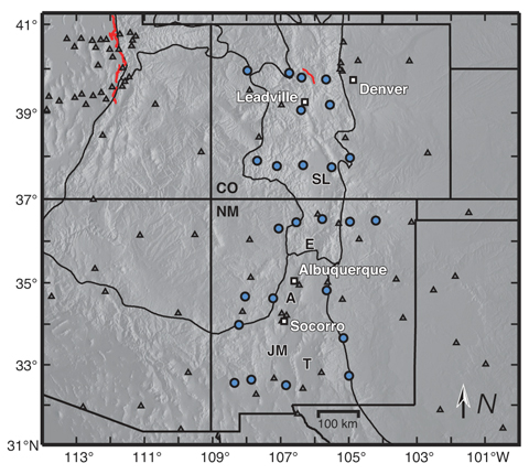
The study was conducted by scientists at the Cooperative Institute for Research in the Environmental Sciences (CIRES) at the University of Colorado at Boulder, in collaboration with the University of New Mexico, New Mexico Tech, Utah State University, and UNAVCO.
“We don’t expect to see a lot of earthquakes, or big ones, but we will have some earthquakes,” said study author Anne Sheehan, CIRES Fellow and associate director of CIRES Solid Earth Sciences Division. “We use continuous measurements of GPS sites from across the Rio Grande Rift, Great Plains, and Colorado Plateau to estimate present-day surface velocities and strain rates,” Sheehan said.
Using GPS instruments at 25 sites in Colorado and New Mexico, the team tracked the rift’s miniscule movements from 2006 to 2011. The team found an average strain rate of 1.2 nanostrain each year across the experimental area. A nanostrain is a change in length of one part per billion, thus 1.2 nanostrain per year is equivalent to 1.2 millimeter per year extension over a 1000-kilometer length.“If you picked two points in New Mexico, and one of them lies 100 kilometers to the west of the other, then they would be moving apart at a rate of 0.1 millimeter per year,” explained researcher Henry Berglund.
Researchers used data from 25 continuous GPS stations installed as part of the EarthScope Rio Grande Rift GPS experiment, supplemented by data from other GPS monuments in the southwestern U.S., resulting in a data set of daily position estimates of 284 GPS monuments for the years 2006 through 2010.
“It is lower than we thought but it does exist,” Sheehan said. “Some people thought it was zero but we are seeing things are extending slowly.”
The slow rates of motion made previous attempts to determine tectonic activity difficult. Previously, geologists had estimated the rift had spread apart by up to 5 millimeters each year but the errors introduced by the measuring instrumentations were significant. “The GPS has reduced the uncertainty dramatically,” Sheehan said. “This is the most comprehensive and accurate set of geodetic measurements in this area to date.”
The extensional deformation is not concentrated in a narrow zone centered on the Rio Grande Rift. Instead, it is distributed broadly from the western edge of the Colorado Plateau into the western Great Plains — a span of more than 370 miles. “This unexpected pattern of broadly distributed deformation at the surface has important implications for our understanding of how low strain-rate deformation within continental interiors is accommodated,” Sheehan said. “Questions we wanted to answer are: how is the Rio Grande Rift deforming? Is it alive or dead? Is it opening or not?”
Along the rift, spreading motion in the crust has caused magma to rise to the surface, creating long basins susceptible to earthquakes. “The rift is still active,” Sheehan said.
The team plans to continue monitoring the Rio Grande Rift, and may attempt to determine vertical as well as horizontal activity to determine whether the Rocky Mountains are still uplifting.
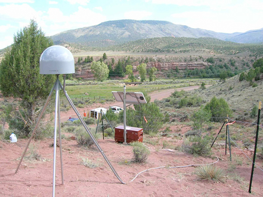
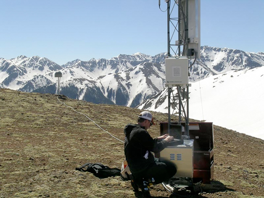
University of Colorado (Boulder) student Henry Berglund services GPS site RG20 west of Silverton, Colorado.
The study’s findings shed light on how continents deform away from plate boundaries, Sheehan said. At plate boundaries scientists can clearly see what is going on. “Things move past each other and crash into each other. At active plate boundaries, the rates of motion detected by GPS can be centimeters per year. Compare that with the fraction of a millimeter per year that we have measured for the Rio Grande Rift.”
“Present day measurements of deformation within continental interiors have been difficult to capture due to the typically slow rates of deformation within them,” Berglund said. “Now, with the recent advances in space geodesy, we are finding some very surprising results in these previously unresolved areas.”
The National Science Foundation funded the study. EarthScope and UNAVCO provided instruments, equipment, and engineering services. Results of the study were published in the January 2012 issue of Geology magazine.
GPS monuments in the vicinity of the Rio Grande Rift and southern Rocky Mountains. The study included construction of 25 GPS monuments (blue circles) in Colorado and New Mexico in 2006 and 2007. Regional EarthScope Plate Boundary Observatory and Continuously Operating Reference Station monuments are shown by gray triangles.
In my 20-plus years of involvement in the GPS/GNSS industry, nothing has come close to the LightSquared debate for technical and political complexity, nor for potential effects on nearly every high-precision GPS/GNSS user in the United States. The industry’s destiny is somewhat controlled by a federal agency that is not very knowledgeable about how, when, and where GPS is used — although I’m sure they’ve learned a lot in the last 14 months.
While receiver manufacturers have a firm grip on the technical complications of what LightSquared proposed, they have jockeyed for market position, as information released to the public is filtered through their marketing heads. Finally, media coverage is all over the place, from “LightSquared is doomed” to “this will happen.”
On January 13, as we all know, the U.S. deputy secretaries for defense and transportation wrote, on letterhead of the Space-Based Positioning Navigation & Timing National Executive Committee (PNT EXCOM), to the head of the National Telecommunications Information Administration (NTIA), declaring that “there appear to be no practical solutions or mitigations that would permit the LightSquared broadband service, as proposed, to operate in the next few months or years without significantly interfering with GPS.”
On February 14, the NTIA director wrote to the Federal Communications Commission (FCC) chairman in a similar vein with nearly the same language. That same day, the FCC stated its intent to “not lift the prohibition on LightSquared,” and to “vacate the Conditional Waiver Order, and suspend indefinitely LighSquared’s Ancillary Terrestrial Component authority.”
It just so happens that LightSquared cannot accomodate military GPS users nor aviation GPS users. Those of you who use high-precision GPS can thank your lucky stars that the military and aviation folks are standing in your corner. Otherwise, as I warned back in May of last year, high-precision users would have been thrown under the onrushing bus of national broadband.
In testimony to a House of Respresentatives subcommittee meeting on GPS and aviation in early February, the Transportation deputy secretary revealed that the Federal Aviation Administration (FAA) spent more than $2 million of taxpayer dollars with two different independent labs to conclude that LightSquared proposals were not compatible with several GPS-dependent air safety-of-flight systems.
Don’t expect the Department of Defense (DoD) ever to provide similar testimony. The Pentagon played its veto card off-air and out of the public eye.
LightSquared has continued to complain about GPS receivers “looking into our spectrum” as the reason for the interference GPS receivers are suffering. If you missed Richard Keegan’s December 2011 article in GPS World, you should take a look. He succinctly addresses this issue, as I did in my November 2011 Survey Scene column.
As LightSquared has clearly lost the engineering argument, it has taken a very creative approach in an attempt to convince the FCC that this isn’t an engineering problem, but rather all about the FCC rules. LightSquared petitioned the FCC to confirm that “GPS devices are not entitled to protection from interference.”
Crazy statement? If you think so, see if you recall reading this statement on equipment such as GPS receivers. It is on almost every electronic device that relies on radio signals.
“This device complies with Part 15 of the FCC Rules. Operation is subject to the following two conditions:
“(1) This device may not cause harmful interference, and (2) this device must accept any interference received, including interference that may cause undesired operation.”
What if LightSquared can convince the FCC that GPS receivers do, indeed, fall within the confines of Part 15 of the FCC rules and aren’t entitled to interference protection? That’s what the company is trying to do, and that’s why this fight ain’t quite done.
Don’t underestimate the power of the White House pushing the National Broadband Plan, or of commercial interests — of which there are myriad — seeking to turn a buck on the hunger, whether real or only perceived, for limitless broadband. Even the transportation depsec allowed in his testimony as how “in the Obama administration, we believe deeply in what LightSquared is attempting to do, which is to make the Internet more accessible to more people all across the country. This is an urgent national priority.”
Communications for My RTK
Some people in the GPS industry who believe that the LightSquared service will do wonders for RTK operations, somehow replacing the communications methods we currently use (UHF/VHF, 900MHz, GSM/GPRS, CDMA, Wifi/Mifi, etc.). I disagree.
LightSquared was relying on Sprint’s infrastructure (~31,000 towers) for its terrestrial operations, supplementing them with ~3,400 LightSquared towers at some point. I’ve used Sprint’s mobile phone service for about 12 years and I used Sprint’s data card service for several years (not any longer). I pretty much know that Sprint is good for metro areas and poor for rural areas. Like other wireless providers (AT&T, Verizon, T-Mobile, etc.), Sprint is strong in some geographic areas, and weak in others. Since LightSquared is focused on serving people (densely populated areas) rather than geographic areas (e.g., farmlands), their terrestrial service is not going to be even close to being nationwide. LightSquared’s solution for areas not covered by their terrestrial service is to use satellite communications for Internet connectivity.
If you think you would enjoy ubiquitous coverage with satellite communications for your RTK operations, consider OmniSTAR’s service, which is in the same spectrum as what LightSquared proposed. OmniSTAR works great when there’s a clear view of the sky to one of OmniSTAR’s satellites (ironically, operated by LightSquared) such as in the agriculture industry. But I’ve used it a bit and — just like GPS — it doesn’t work in buildings, in vehicles, under trees, or in other obstructed-sky locations.
Can you imagine using a LightSquared mobile phone that doesn’t work in buildings, in cars, or under trees? You wouldn’t. Anyone who’s ever used RTK knows that spotty base/rover communications is the quickest way to spoil an RTK party. With GPS/GLONASS receivers allowing us to use RTK in places where we’ve rarely ventured before, the limitation wouldn’t be the number of navigation satellites in view, but rather if the LightSquared satellite was in view.
For those of you who heard that LightSquared might have been a good idea in order to make wireless mobile Internet access more affordable, I seriously doubt that statement as well. Documents in a huge Freedom of Information Act release by the FCC reveal what LightSquared was planning to charge its wholesale customers (not retail) when they were out of range of the terrestrial system and forced to use LightSquared’s satellite for wireless broadband. The wholesale cost of their satellite broadband service was to be $10 per megabyte (not gigabyte), an astonishingly high price for a company that’s been touting affordable, nationwide wireless broadband Internet service.
Upgrade Costs
A cool $2.4 billion was the official estimate given for aviation industry upgrades, should LightSquared have gone forward. I think that’s conservative because I doubt it covers the infrastructure upgrade cost (WAAS, GBAS, and so on) or the cost of NextGen program delays.
How about something closer to home? I queried the administrator of a statewide RTK network of 103 GNSS reference stations, and used his estimates to extrapolate national costs in that regard: 7,000 CORS receivers across the United States. They look like this: optimistic scenario, $64 million; likely,$92 million; worst-case scenario, $120 million.
Keep in mind that this is only the high-precision GPS/GNSS infrastructure in the United States. There are still hundreds of thousands of high-precision GPS/GNSS receivers owned by users across the country that would have to be upgraded. For many GPS receivers (think handheld), there will be no upgrade solution, so the manufacturer might offer trade-in credit for a new GPS receiver.
After spending time to understand the actual costs of accomodating LightSquared, one state legislator who initially voiced his support for LightSquared said “we can’t afford it.”
New Beginnings
Included in the NTIA report was a recommendation that, with time, GPS receivers could be redesigned in order to accomodate LightSquared’s 10L signal.
NTIA also reported that during the January 13 EXCOM meeting, it was agreed that “federal agencies will move forward this year to develop and establish new GPS spectrum interference standards that will help inform future proposals for non-space commercial uses in the bands adjacent to the GPS signals and ensure that any such proposals are implemented without affecting existing and evolving uses of space-based PNT services vital to economic, public safety, scientific, and national security needs.”
In summary, GPS/GNSS receiver designs will change in the coming years and move towards more efficient use of spectrum. To me, a critical statement in the NTIA letter to the FCC is “without affecting existing and evolving” — meaning that not only should GPS be considered, but also GPS-like systems from other countries such as Russia’s GLONASS, Europe’s Galileo, and other developing satellite navigation systems and applications.
ERIC GAKSTATTER is contributing editor for survey of GPS World, and editor of Geospatial Solutions.
The Federal Communications Commission (FCC) Office of Engineering and Technology will host a workshop on spectrum efficiency and receivers on Monday, March 12, and Tuesday, March 13, in the Commission Meeting Room at FCC Headquarters in Washington, D.C. The meeting is part of the FCC’s efforts to enhance the use of spectrum for mobile broadband — including LightSquared — and is being held in conjunction with the Wireless Telecommunications Bureau and the Office of Strategic Planning.
The role of receivers in enabling access to spectrum for new services implicates federal stakeholders, as well as the private sector, the FCC said in its announcement of the meeting. “Receiver performance issues have often arisen as a conflict between legacy stakeholders and new entrants where deployment of new technologies and services threatens to adversely impact an incumbent or place restrictions on the new entrant. Past examples include interference issues between new cellular radio systems and public safety radio systems, satellite digital radio systems and proposed terrestrial data services, unlicensed Wi-Fi systems and FAA weather radar systems, and ancillary terrestrial service on mobile satellite spectrum and GPS.
“The resolution of such matters has historically required a public process involving regulators, stakeholders and other parties. Because such discussions sometime begin upon the introduction of a new service or technology, full deployment of such new services could be hindered. New approaches to spectrum management focusing on spectrum efficiency and receiver performance may enable more assured deployment of new services and reduce the necessity for the involvement of regulators.”
The two-day workshop will discuss the characteristics of receivers and how their performance can affect the efficient use of spectrum and opportunities for the creation of new services, the FCC said. Key topics will include current practices for receiver design, case studies involving interference due to receiver characteristics, and approaches for promoting interference avoidance and efficient use of spectrum, given the current receiver base and potential future deployments. The workshop will include perspectives from licensees, equipment manufacturers, component providers, and other interested parties.
For more information, contact Michael Ha, Office of Engineering and Technology at (202) 418-2099 or by email: [email protected].
Accessibility Information. To request information in accessible formats (computer diskettes, large print, audio recording, and Braille), send an email to [email protected] or call the FCC’s Consumer and Governmental Affairs Bureau at (202) 418-0530 (voice), (202) 418-0432 (TTY). The public notice can also be downloaded in Word and Portable Document Format (PDF) a FCC.gov.
Eric Gakstatter, Survey Scene and GIS editor, along with Gavin Schrock (Administrator, Washington State Reference Network) and Laurence Socci (ACSM/NSPS Government Affairs Consultant) will be guests on America’s Web Radio on Monday, February 27, at 11 a.m. Eastern Time to discuss the latest developments in the LightSquared/GPS interference debate as well as other GPS/GNSS issues.
The one-hour program is hosted and moderated by American Congress on Surveying and Mapping’s (ACSM) executive director Curt Sumner.
You can listen to the radio broadcast by visiting America’s Web Radio website. The show will also be recorded and available on the ACSM and GPS World websites for download.
ACSM, with its largest Member Organization being the National Society of Professional Surveyors (NSPS), was founded in June 1941 and is incorporated as a non-profit educational organization whose goal is to advance the sciences of surveying and mapping and related fields, in furtherance of the welfare of those who use and make maps. ACSM also encourages the development of educational programs and supports publications that represent the professional and technical interests of surveying and mapping. The society is comprised of four independently incorporated Member Organizations which include more than 5000 surveyors, cartographers, geodesist, and other spatial data information related professionals from private industry, government, and academia throughout the world. Each member Organization serves the specific interests of their respective members, while working collectively to achieve the overall goals of ACSM.
This week, I’m pleased to present to you an essay written by Gavin Schrock, a licensed land surveyor (Washington), technology writer and administrator of the Washington State Reference Network (WSRN), which operates 103 GNSS reference stations that comprise the statewide RTK Network. He has written about surveying, mapping, GNSS, civil engineering, GIS, and data management for industry and association publications. He is usually not as cynical as he is when facing potential forced upgrades/replacements/production losses for his profession and the GNSS community.
With plenty of announcements, posturing and news, expect another newsletter shortly from me recapping the LightSquared events of December and January.
Eric Gakstatter
Should GPS Users Accept New “Fees”?
“Eat your spinach, you no good’ infink [infant]’. Eat it. EAT IT. Eat it.!” – Poopdeck Pappy [from Popeye]
By Gavin Schrock, LS
GPS is free of charge; period. Apart from any costs you incur in securing your own equipment to utilize the signals from the GPS constellation, or to subscribe to some augmentation service, there are no direct user fees. This is codified in our nation’s laws; GPS is free of user fees and this policy has remained consistent throughout the history of the U.S. Global Positioning System. End users, industry, public safety, and some international agreements, are based on or rely upon this fundamental, ubiquitous, irrefutable, concept of free!
Not that a fee would not be a great revenue generator; it has often humorously commented on within the Position Navigation and Timing (PNT) circles of the government that if one penny could be charged every time a GPS-based position is generated that there would be no debt. But this is not a serious consideration, and for the very reason we have GPS in the first place: we’ve already paid for it. GPS is essentially a military program, a weapons system “friend with benefits”. Taxpayers own this system. It was funded for and is operated (in an exemplary manner) by the military for specific purposes, but is almost exclusively unique as a military program in that it provides almost unprecedented direct economic and public safety benefits to the civilian world as well. In other words; we really get our money’s worth out of this investment.
The military can keep it free because they reap enough internal benefits to justify the expenditures; like valuable encrypted services for their own national security purposes. Many fear that the military might lose a substantial portion of this justification if such things as P-Code encryption were turned off, as some have suggest (without the newer “M-Code” being fully deployed first) and that bean counters might start looking at fees. Fees are universally so unpopular for dual-use GNSS systems that no other constellation provider does, nor plans to do so, with the possible exception of the European Galileo system; and there is still great internal debate and dysfunction within the EU and the Galileo program on the design of a franchise model for user fees. Some have also tried to characterize expenditures for developing, deploying, operating and modernizing the GPS constellation as “subsidies” for GPS manufacturers and users. Many more view it as: we paid for it, we own it, and it ain’t a subsidy. Are lighthouses and highways considered subsidies?
You can freely look for and receive GPS signals anywhere they may roam, worldwide and in any band they may wander, not just the GPS Band. There are absolutely no restrictions on receiving GPS signals. The FCC regulates transmissions, not reception. You are not breaking any laws or “squatting” if you look for GPS signals in the next band or the one beyond that. You can try to look into an FM band with your VHF radio if you want. It may not make any sense, but there are no restrictions. What one does with received signals can run afoul of the law though (like eavesdropping on private conversations or decoding encrypted national security transmissions), but when it comes to GPS, there are no current restrictions on what you listen to.
That the FCC only regulates transmissions and not reception discounts calls by some (guess who), for the FCC to develop and enforce standards for GPS receivers. The FCC is generally only concerned with what things emit or transmit. A receiver does neither as it is transmissions and emissions that harm other users. There may be no legal standing for the FCC to regulate receivers. The same kind of selective indignation is heard the characterization of GPS units as being “unlicensed” (got a license for your FM car radio?). This is another attempt to deflect from the immediate issue at hand by implying that your GPS gear is somehow breaking some rules, is deficient, or that the manufacturers have been negligent. More storms in teacups?
No Steps Backward, Only Steps Forward
To this date, the gracious hosts of the GPS constellation (USAF) has not implemented any fundamental design changes that would force you to have to change your GPS uses, or incur any additional costs in doing so. Quite the opposite, there have been many improvements along the way which would make one consider a voluntary upgrade. An example of changes for the better include Selective Availability (deliberate degradation of GPS signal) being turned off in 2000. That action was made permanent in 2007 and such actions acknowledge the tremendous lateral benefits of civilian uses. It will not be until December of 2020 (at the earliest) that there will be any major change in the GPS signal (or spectrum) that will render any method or solution for utilizing the GPS solutions unusable or substantially compromised. The planned change is an option that the constellation provider may exercise at that time to no longer support selected elements of the GPS L1 P(Y) and L2 P(Y) signal characteristics. The U.S. Government acknowledges global use of GPS codeless and semi-codeless techniques is committed to maintaining as such for a whole decade for transition. That is an important distinction; a whole decade… there are no “gotchas” (nor should there be) when it comes to such a valuable amenity. This decade for transition primarily provides time for other constellation upgrades to reach fruition, providing alternatives and mitigating for the possible loss of codeless and semi-codeless functionality. That is another important distinction and concept; do no harm to one capability until there are alternatives completely in place to mitigate for the harm/loss.
Don’t Fee on Me…
If the U.S. government was to try to start charging some end users fees directly or via some other means like a surcharge on GPS gear, that would be met with such opposition as to drag the debate out in process and possibly the courts for far more than a decade. Such an action would also be breaching some hard wrought international agreements. Implementation of direct fees would be as improbable as being struck by a falling GPS satellite.
Now, if the constellation host (USAF, or if forced by another agency) were to make a design change that enabled a specific private entity or group of entities to be able to charge for use of the system (i.e. like an encryption, or spectral change that might cause you to have to buy some proprietary gear) then that would be a fee and that scenario would surely cause an even bigger storm!
But what if a U.S. government regulatory action rendered your current gear to become obsolete in some way? That you would have to incur expenditures to continue to use the very system you paid for, and through no fault or action of your own – would this in affect be a “fee”? (You probably know where I’m going with this). Some say this is moot, because (in their eyes and marketing dreams) your gear is already “obsolete”, and you should buy their gear right away.
Obsolete?
One would not expect the definition of a word like “obsolete” to be highly debatable, but one would have never expected a word like “ancillary”, or Ancillary Terrestrial Component to be up for debate either.
From the FCC: (“We clarify that ‘integrated service’ as used in this proceeding and required by 47 C.F.R. § 25.149(b)(4) forbids MSS/ATC operators from offering ATC-only subscriptions. We reiterate our intention not to allow ATC to become a stand-alone system. . . . We will not permit MSS/ATC operators to offer ATC-only subscriptions, because ATC systems would then be terrestrial mobile systems separate from their MSS systems.”).
Sorry, got sidetracked there. Obsolete. Now look at your high precision GPS gear, the gear that you maybe even purchased within the past year. If you were to use that gear today, you would have a reasonable expectation of a certain level of precision and reliability from that gear. There are no planned constellation/signal changes before the end of 2020 that would otherwise negatively impact the expected precision and reliability of your gear. Barring events or conditions completely out of your control, or that of the constellation hosts (natural or manmade disasters, invasions of GPS eating zombies, etc) your gear will not be in any way “obsolete” (with regards to current functionality) before 2020 at the earliest (and may still function long after that).
Your smart phone might be deemed “obsolete” by some of your technophile buddies because a new one came out, but yours still works. On the other hand some have opined “just because a company builds an electric car does not mean we should shut down all gas stations”. Comparing consumer level devices to expensive and sophisticated high precision GNSS gear is like comparing grapes and watermelons. Folks do not take too kindly to others telling them their gear is obsolete, or poorly designed – quibble about the details, but they don’t take too kindly just the same.
But what could make your gear obsolete? Apart from the previous scenarios (and no insult to folks who believe in GPS eating zombies) there are things out there that could potentially compromise your ability to use your current gear, but none, other than things like space weather and malicious jammers (that deliberately set out to mess with current GPS capabilities), are not within your realm of control, or for the most part the control of the constellation providers. However, there is that controversial broadband plan under review that sets out to introduce a new source of interference (that does not currently exist in the specific form, strength, and coverage) being so heavily debated during this past year.
If this perpetually-revised broadband plan is to be given the go ahead, then a new source of interference will require an upgrade or replacement of many high precision and general navigation and aviation GPS units, and if the costs of upgrades and production interruptions fall on the end users, this will, in effect, be a “fee” (or at least smell like one). Likening these costs to a fee is not any crazier or out of line than the barrage of claims and counter-claims brought about by this recent GPS-Broadband “mad as a box of frogs” debate. There are all kinds of arguments, or rationalizations of unpopular positions, that run the gamut from specific technical considerations, politics, deflection, projection, test result rejection, lobbyist injection, to “we already have full rights to do this, GPS must accept the interference.” If that were the case, then why did there have to be a waiver? – and a waiver with strict conditions attached at that?
The broadband applicant and the GPS industry have sparred mightily. Have the conditions of the waiver been met? Who’s fault was it? Bad receiver designs or flawed and rushed broadband plan? [Insert your own favorite rhetoric or talking point here]. Leaving all that aside for a moment, a big overlooked question is, what about the innocent bystanders that will take the heat if it is approved? The end users subject to a new “fee” of sorts. While there is fleeting mention of the “who pays?” in the deliberations (that only seems to go as deep as “the other guys should pay”), no party has set forward a practical plan to cover those costs other than the end user eating them. The highest probability is that the end user will have to eat this “fee” and that will be quite a blow to many people.
Is the fix in, for the fix that is in?
There has been a lot of alchemy going on over the past year with regards to this matter; attempts to turn straw into gold; like the effort to turn low-cost satellite spectrum into golden terrestrial spectrum, and more recent efforts to try to spin what will amount involuntary upgrades (“fees”) as some kind of “gift”. Involuntary expenditures end users will have to incur, to continue to use their perfectly fine GPS gear and perfectly fine spectrum and perfectly fine constellation, as they were designed for and as they are accustomed to, are a defacto fee! To try to spin something so unsavory into a gift, gem, or blessing in disguise, is being viewed widely viewed as self serving and somewhat disingenuous. There is a reason why alchemy went out of style centuries ago by the way.
One way to help someone swallow something unsavory is to sugar coat it, convince someone that it does not taste too bad and won’t make them sick, or wrap it in something that appeals to them. It is very likely that all manufacturers will see fit (if the plan is indeed forced on us) to sweeten the deal to soften the blow, offer incentives, and throw in cool features. No matter how cool the deal is, and what amazing features “you’d be a fool to pass up” are, there is still an element of being forced to pay to be able to continue to use GPS as you are accustomed.
Setting aside this controversy for a moment, there are several schools of thought about upgrades. Like any product, developers (even sometimes with the purest of intentions) work very hard to develop new features and hope we see those as valuable enough to spark an upgrade or replacement purchase. This can be wonderful and with healthy competition we benefit from options for both “nice to have” new features to groundbreaking “must have” features. High precision GPS gear is not consumer GPS gear, and most folks do not buy every new unit that comes out. Do you buy a new car every year? Most need to get several years of use out of the gear to realize cost-benefit, but for others a constant upgrade can pencil out. The growing popularity among heavy users (especially construction) of leasing gear ensures all of newest features, configuration, and firmware (remember that every support call starts with “what firmware version are you on?”). This does not work for everyone and so far as there has not been a forced upgrade or other planned obsolescence, users have reasonably expected many years of reliable use out of their current gear.
Selling (and opposing) the controversial broadband plan that sparked this flurry of debate, has been a well-funded and ongoing effort. No one disagrees that more wireless would benefit a lot of people and even laterally the very end users that will have to pay the “fees” to make it a success. We’ve been told that this plan heralds a new chapter/era/breakthrough in wireless. But it is not like there is some amazing new technology in play that could not be served by other plans, existing or in the works, that do not hurt GPS, and then we find out that the plan might not be as ubiquitous as we might think.
We’ve been told that this is an epic battle between and “obstructionist GPS community and the very future of broadband!” Not quite; LTE is already here, growing, and there are quite a few other initiatives under way, including several hybrid satellite-terrestrial proposals that do not pose immediate threats to GPS. Opposition to this plan does not impact the entire future of all broadband. Plus there is a substantial amount of spectrum being “sat on”, and numerous tests show seriously underutilized spectrum. This has more to do with operational, marketing, and poorly functioning systems that just needs good management and policies. Of course more spectrum needs be sought over time, but why are some of the more recent (and vocal) advocates (even from within the GPS community) for this specific plan so hung up on the supposed “criticality” of this one specific plan. Wouldn’t it be better for both the expansion of broadband and the GPS community to advocate for better management of existing spectrum? Or is it better to zero in on one piece of spectrum that represents a hazard to current GNSS? How about working on underutilized spectrum and give sufficient time to work out solutions for the MSS/GPS bands? This haste and laser focus on this GPS-unfriendly option raises a lot of questions and hackles as we have seen.
We’ve been told variations over time how the interference can “all be fixed with a ten cent filter” to “some components only cost $6″, to $300, to $800, to $5,000, to a thousand bucks a year, to… (lets drop that for a moment). We’ve also been pitched that the plan will bring forth a new cut-rate nationwide RTK network (which may not be as practical or nationwide as some might think). Though there would be benefits of more wireless choices, and a great many investors would benefit as well; does one segment of the population have to take the bullet for this success?
New features added to sweeten the deal might be well worth the cost when separately considered as a voluntary purchase (or not), but if someone wants to eschew the sweeteners, can they get upgraded for free?
A spoon, or shovel full of sugar helps the medicine go down…
Manufacturers have always admirably striven to create new and amazing features, and then the sales and marketing folks have to turn those into “must have” features. This latest move with the “GPS upgrade fee sweeteners” is not an exception. Some sweeteners that will likely be added to the “GPS upgrade fee” might be “must have” to some, but might include features that are not quite ready for prime time in the view of some, or do not solve “make or break” issues for other end users. End users are savvy enough to decide what to buy and when, and if not forced to do so will buy based on business needs and cost benefits. Folks do not take too kindly to salesmen implying that they are “fools for not taking advantage of this deal”.
For example, a forced upgrade might be offered with modifications to get access to more constellations and signals (for the limited numbers of receivers that can take that kind of upgrade). A lot of folks already have with their current gear, L5, Galileo, and other signals capability (or at least placeholders and will be waiting years before those come to fruition). Others wait until a constellation or signal is fully deployed before making a big purchase or commitment. It was announced December 27th, 2011 that the Beidou/Compass constellation has been declared operational, but how many years before that will make any difference to you in the field? Trying to sell something that is not yet ready for prime time can have mixed results. Do you remember the dark times of the old Glonass constellation? Unlike today when it has been successfully modernized and is at full deployment, there were past precision issues reported when using Glonass. I asked a few manufacturers why a decade ago they did not heavily market their early Glonass capable gear, one response was “we did not want a customer to go out there and get [poor] results and then blame us for pushing Glonass on [them]”. Many users may be wise wait until these new constellations and signals have matured.
A noble ambition/feature is to solve the filtering for not only this pending issue but for all forms of interference, and this has been tacitly offered as up another sweetener. With the timeline too short to pull this off before approval of this broadband plan hanging over our heads aside, are end users currently really being crippled by existing sources of interference? Not to deny the potential harm of various types of interference, but is the timing of this “awareness heightening” by some supporters of the broadband plan a case of (to paraphrase L. Frank “Oz” Baum) “pay no attention to the [broadband plan] behind the curtain”?
The U.S. GPS Interference Detection and Mitigation Program (IDM) is a serious undertaking. There are reporting elements like the Patriot Watch portal (closed to the general public) and support/notification services (for not only interference but constellation updates and other alerts) from a “GPS Triad” formed by the USAF (military issues), the FAA (airspace issues), and U.S. Coast Guard (surface issues) already in place. I’ve queried these entities, as well as a number of RTK network operators and have not come up with a huge number of verified examples of interference that would significantly affect high precision users. I’m not saying that “the Orc we fear is worse than the Orc we hear”, but like any other element of risk assessment there should be serious analysis of incident data and testing before we rush off on a potentially costly course of action based in part on anecdotes and compound assumptions about interference.
There have been several (but few) well publicized cases of interference that do present cause for concern, in particular the accidental military source disruption in San Diego in 2007, and the cheap “trucker jammer” that affected an airport in New Jersey. But for non-jamming or military sources (that are not typically turned on in populated areas) the other more commonly suspected sources of interference are often recognized and avoided (e.g. certain types of power lines, some sat-phone handsets, and some high power distribution substations). There are also users successfully working in areas one would highly suspect for interference, but are not necessarily a hazard; like in and around airports, military installations, and even on hilltop antenna farms, without loss of precision.
That is not to say that interference is not a threat nor that jamming might not harm operations. Jammers are highly illegal and of course some folks will use them. You put the idea in a users head, and then the otherwise systematic debugging of field operations issues can take on a whole new element of paranoia. We’ve even fielded support calls this past year with frustrated field users asking “could this be interference from LightSquared?”, a system that has not even been turned on yet. Efforts to build affordable detection devices is a noble cause. There have been some great strides in analyzing this issue and developing new tools. The problem with serving up these things as a sweetener added to a forced upgrade, or as a tool to deflect attention away from the immediate broadband-plan issue, is that many view this in some way disingenuous. Right or wrong, the timing and nature of how this has been spun may serve to taint the otherwise worthy issue of a broader interference.
More at stake than your GPS unit
Sweetening the deal and softening the blow for one limited segment of GPS users, like the surveying profession, or other specific type of GPS equipment, completely ignores other issues that can be viewed as much more compelling than that of the individual.
Aviation: Can the same model of cheap, quickie upgrades (and sweeteners) be applied to aviation? Some of the most compelling concerns have come from the aviation community and FAA Advisory report. To assert that one could go up to a plane on the tarmac, crack open the GPS unit, put in a few cheap components and then send a hurtling can of people into the sky sounds more than reckless or insulting. Developing, acquiring, testing, certifying, installing and then testing again of aviation components is time consuming and expensive, and cannot be taken lightly.
The same solutions for limiting interference in cell phones may not be applicable to other types of gear, and may be completely ludicrous for others. In the case of cell phones, these are narrow band (only using about 6%, or 2MHz of the 32MHz of GPS signal) as they are not concerned with precision, and many utilize Assisted GPS (AGPS); an augmentation to improve the slim pickings from such a narrow band view. High precision units, and most general navigation GPS, plus aviation, and most military are “wide band”. There is a huge difference between a cell phone being tested in a purely pass/fail mode; more for “conformance”, than for “performance” and a high precision unit that uses (perfectly legitimately) as much signal as possible to achieve such high precisions as many rely upon.
No one would disagree that there are engineers that have been rolling up their sleeves and working on new and improved filtering options, but at this point in time, there is a sort of “spectral gun” being aimed at the end users. The view is quite a bit different from down here at the business end of said gun than from the point of view of those who are so cavalier about this subject on the trigger end. In this charged atmosphere of the current controversy, we may really need a “hype filter”. Is it too much to ask that such grand filtering ideas be backed up with solutions that have been developed and tested for every type of GPS unit well in advance of anyone monkeying with the spectrum? Sure one can assume that anything can be fixed with enough time and money; seems to be no shortage of money, but how about time? Back down the throttle a little and let this plane come in for a safe landing.
Hold the Cheeseburger
Wrap up something unsavory in a double-patty-pickles-onions-cheese-on-a-sesame-seed-bun and we are still being forced to consume something unsavory or disgusting– and don’t expect us to think folks are heroes for selling us a toothbrush.
Opposition to the plan has not been limited to the GPS manufacturers or satellite communications providers who would stand to lose something in this matter. The U.S. military, aviation, agriculture, and public safety are among the others who have arguably had more say in the matter. There have been some accusations that all opposition is contrived, or based solely on conflicted interests – don’t insult us. Yes, the end user may be only looking at the costs of upgrade/replacement/production interruption but what of those who stand to gain either financially or in stature from this if approved?
Why would parties from even within the GPS industry and community (some call “turncoats”) advocate for introduction of this new specific form of interference and inflicted forced upgrades/replacements on their own industry and end user community, and then try to spin that as some kind of gift, or path to a “better world”? Some would suspect profit, or there may be pure intentions involved, though the latter might make one think about those old spy/action movies where some group is planning to disrupt the world so that they can rebuild a more perfect world according to their plans or beliefs. Good intentions, but…
If this broadband plan is given the green light (and even if it looks like it might not fly), or not, it may serve as a harbinger of things to come. If it fails, it is not the end of broadband or the world as we know it, and perhaps a good long term plan to manage spectrum and constellation could come of this. It would be a fantastic goal/role for joint PNT/FCC cooperation, but these things cannot and should not be rushed. Wow, managing something effectively, am I dreaming?
If approved though, all of the manufacturers will have to offer some kind of deals to soften the blow. The end user may have no choice but to upgrade or replace, but they will have a choice in how they do this and who they patronize. Some sweetener peddlers have jumped the gun and have touted cost-benefit computations of the upgrades (based in part on some aforementioned arguable assumptions) that (they say) may only cost you the price of a burger a day; couple of bucks a day (or 50 Rubles, or whatever currency equivalent as many might turn to cheap GPS gear from overseas if forced into this). Many have expressed how insulted they feel about this attempt to minimize their concerns.
People will not easily forget those who blatantly advocated for what many consider to be a rushed-reckless spectral disruption. Many end users have indicated that they will seek to pay (if forced to) these “fees” to other companies who did not support the potential harmful broadband plan, exercising what little choice or influence they have in this matter. Or at least if the GPS eating zombies do attack, they might be tempted to trip some of those turncoats.
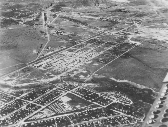
A U.S. Army camp near Townsville’s suburban areas, circa 1944.
By Tracy Cozzens
Beneath the surface of a tropical paradise in the city of Townsville on Australia’s Sunshine Coast lies a hidden maze of tunnels and underground bunkers, once said to be used by General Douglas MacArthur. Learning the secrets of this labyrinth that was a major World War II staging point for battles in the Southwest Pacific is the passion of Kevin Parkes of Geo Positioning Services, Townsville.
Parkes’ main tool is historic aerial photography, coupled with hours of research in the National Australian Archives and the National Library of Australia. To that he adds geophysical surveys of the infrastructure. Parkes is undertaking the geophysical surveying and mapping using an Ashtech ProMark 100 GNSS receiver and a Willy Bayot PPM Mk 3 magnetometer. He used the magnetometer and GPS receiver in parallel, later processing both data sets.
After the attack on Pearl Harbor and the Japanese advance through Asia, Townsville’s population bloomed from 30,000 to 120,000 by mid-1943. The rapid military influx stretched resources to the breaking point.
The U.S. Army 5th Air Force established the largest aircraft repair and maintenance facility ever built in the southern hemisphere at Townsville, and the site became the technical hub of U.S. military aviation. Air Force Service Command Depot #2 at Townsville was capable of overhauling 300 aircraft engines per month and performed aircraft assemblies, modifications, overhauls, and maintenance. Major resources and facilities serviced the Royal Australian Air Force, Australian and U.S. Armies, Royal Netherlands Air Force, Royal Air Force, Canadian forces, Royal Navy, and other allied forces.
“A visitor to Townsville today would be forgiven in asking where the artifacts of this massive military facility are today,” Parkes said. “There is very little remaining in any built structures that give any idea of what happened in this city 70 years ago.”
Parkes realized that underground cave shelters were most likely used for warehousing and storage, to keep stores out of the weather and protected from enemy action.
He describes one area he investigated, a park in Townsville used as an officer’s accommodation camp. Preliminary magnetic anomaly surveys indicated linear anomalies were beneath the park surface. A high-resolution survey gave samples of about 1.5-meter resolution.
“The difficulty was reducing all noise levels down to a minimum, including the X/Y positioning, so the GPS requirements came down to survey quality,” Parkes said. “It is absolutely critical that the GNSS receiver and magnetometer keep in synchronization during data collecting runs including under the frequently encountered tree canopies.”
To improve accuracy, Parkes avoids using real-time kinematic survey equipment. “That would involve having another electronic device operating and emitting more noise in the signal spectrum,” he said. The need to position the GPS antenna in close proximity to the magnetometer sensor was a major issue with all on-pole RTK systems.
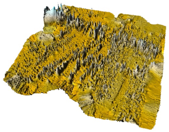
A U.S. Army air raid shelter under the officer’s accommodation camp, mapped with GPS and magnetometer data and using Surfer 3D surface mapping software.
With an Ashtech Promark 3, post-processed results were better than 100-millimeter X/Y coordinates. “The unit is lightweight and self-contained,” Parkes said. “The noise from the Ashtech survey-grade external antenna’s effect on the magnetometer data was insignificant.”
Still, this park had a grove of trees that defied every attempt to maintain GPS reception and consequently synchronize the magnetometer. Along came the Ashtech ProMark 100, a lightweight and self-contained receiver with external geodetic antenna with GPS and GLONASS. “My first attempt at surveying under the trees was spectacular to say the least,” Parkes said. “Synchronization with the magnetometer data was near perfect.”
The dual-constellation reception of the ProMark 100 became essential to the success of Parkes’ work. After more than a hundred data-collection passes with the magnetometer and ProMark 100 through the groves of trees, at no time did the Position Dilution of Precision (PDOP) rise to more than three, and at all times more than eight satellites were available. The ProMark 100 data is post-processed to improve accuracy. Parkes noted that ironically many of the most interesting finds have been collected under heavy tree canopy. Without the quality of the geographic positions enabled by the ProMark100 under tree canopy, Parkes said that much of his work would have been impossible to achieve.
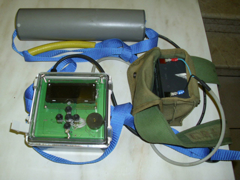
Parkes’ surveying equipment includes a magnetometer and a ProMark 100 GNSS receiver.
In fact, when Parkes first began his mapping project in 2005, he used a single-constellation GPS system and post processed the results against the local International GNSS Service (IGS) reference station. The GPS-only system worked very well until a grove of trees would interfere with the sky. Now with the ProMark 100 GNSS receiver, Parkes surveys using GPS L1 and GLONASS in continuous kinematic mode at a one-second collection rate. He then post processes the data against another ProMark 100 used as a local reference station.
To date, Parkes has mapped an underground railway, artillery observation posts, several shelters, fuel terminals and other yet-to-be-identified pieces of the vast infrastructure.
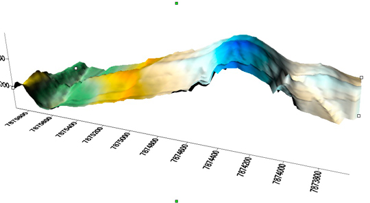
During his Research, Parkes mapped a major magnetic anomaly in Cleveland Bay. In 1770 Captain James Cook in the HMS Endeavour mapped the east Australian coast. Venturing into Cleveland bay, Cook noticed his compass behaving erratically, and named one island Magnetic Island. Today, a 3D surface model reveals a large magnetic anomaly heading across Cleveland Bay and straight towards Magnetic Island, 7 kilometers from Townsville. Experts who have examined the data believe that it is a naturally occurring magnetic anomaly about 800 meters wide. “It would appear that Captain James Cook was indeed a very capable navigator and cartographer,” Parkes said.
Gavin Schrock, LS, is a licensed surveyor, technology writer, and administrator of the Washington State Reference Network, a regional cooperative GPS network (RTN) in the Pacific Northwest. He has worked in surveying, mapping, data management, and GIS for over three decades in the civil, utility, and mapping disciplines. He has published in these fields and has taught these subjects at local, state, national, and international conferences.
Some folks are proposing that a nationwide RTK Network (RTN) be piggy-backed on the controversial LightSquared communications network. That could be cool, if it can be done. No one is saying that it can’t be done, but there are reservations on whether it would be worth the massive investments needed to pull it off, and that there might be little gain at all over the existing presence of RTN in the U.S.
RTN are arrays of continuously operating GNSS reference stations that can provide correctors for high precision positioning. Centimeter positions instantaneously; imagine what could be done with a capability like that. People have not only imagined such things, but have implemented over 100 of these in the U.S. and over 350 worldwide serving industries such as surveying, mapping, construction, precision agriculture, science, machine control, public safety, precise navigation. If you feel you have heard all of this before, you probably have, and chances are you might have heard this from an RTN junkie like me.
I am a strong supporter, even a rabid supporter and promoter of the expansion of RTN and the many benefits that can be realized where RTN exist. I have bored many people to tears with my idealistic ramblings about RTN, and have seized opportunities to jump on any bandwagon that promotes more widespread or even nationwide RTN (e.g. On-Grid Goal, GPS World 2006). There are many countries that already have nationwide RTN like Japan, Germany, Denmark, Greece, and many others; but under completely different circumstances, and none piggybacked on communication network towers. So why haven’t we seen a nationwide RTN in the U.S.? There are a lot of good practical reasons why this has not happened, and likely won’t. It is not a matter of a single design or business model issue standing in the way, and likewise the solving of a single issue will not bring the entire dream to reality. There are far too many moving parts to an RTN; hurdles that would have to be overcome to realize a nationwide RTN. Examining those hurdles might bring us closer to visualizing the dream, but perhaps instead we should focus on what is realistically possible and provide the best possible amalgam of many well run RTN to provide the same utility.
The Nationwide RTN Carrot. In the course of the past year, and the LightSquared broadband plan interference controversy, RTN have been mentioned in the context of both a reason to oppose the broadband plan in question, and by others as a reason to support the broadband plan. Some have suggested that the LightSquared plan in question would be the catalyst for a nationwide RTN, as it could possible fulfill the crucial communications element of an RTN, and have touted this as a carrot for approval of the entire broadband plan. The idea of piggybacking an RTN on a communications network towers is not a new idea, and it has been studied seriously by many folks, including myself. There have been GNSS manufacturers and mobile phone service providers who have looked at this idea; but none that have acted on the idea; for good reasons.
I would really like to see a nationwide RTN, but this particular carrot is not backed up yet by a credible plan that has been formally proposed and presented for scrutiny, it does look mighty tasty at first glance. Are there too many compound assumptions being made with regards to this particular carrot? Or is there real potential for a grand RTN? The controversial broadband plan asks a lot of people to sacrifice a lot in direct costs and lost productivity during transition; so the various carrots being touted should be scrutinized very carefully. The first glance look at the assertion that a nationwide RTN could be piggybacked on the proposed LightSquared LTE build-out does appear to provide two key RTN elements: secure station sites (perhaps as many as 40,000 to choose from) with power and low-latency communications for both stations and rovers. But are tower sites really suitable? And can it be done with the tower sites alone? Can it be done in a manner that would greatly improve the coverage of RTN and at a dramatically lower cost? Let’s takes a closer look at what it would take to stake a nationwide RTN on an array of wireless communication towers before we jump to any conclusions.
Secure sites with power. Yes, the proposed tower sites are essentially cellular tower sites with fences and reliable AC power. But the assumption that one can simply rely on tower sites only applies to the limited area of the country that will be covered by the terrestrial component, the rest would need new stand-alone CORS sites to be presumably served by the satellite component of the plan (not a good idea and adds more infrastructure costs).
Tower mounts. A communications tower is subject to movement, and therefore not a good candidate for mounting a high-precision GNSS CORS antenna. Even as little as one centimeter of incidental movement (and much more in high winds) is not only not a good practice for an RTN station, it would compromise the relative integrity between RTN stations and the resultant real-time solutions. If you expect your rovers to achieve centimeter positions, the RTN stations must be stable to a few millimeters. But don’t cell towers already have GPS antennas on them? Yes, but these are typically tiny little single frequency units used to time the communications systems where positional precision is not a consideration.
Co-Location at Tower Sites. You will not find very many RTN stations co-located at wireless communications tower sites, and those that are have been placed on stable ground mount far from tower (south side preferred for maximum constellation) to mitigate as much multipath from the tower as possible. Most tower sites are not big enough to accommodate this. It may take a separate lease of a fenced area far away from the tower. This greatly reduces the number of potential sites.
Leases. Wireless communications tower sites are mostly leased from local land owners, and the towers themselves are often owned by third parties from whom communications companies lease space on the towers. The LightSquared plan is not calling for wholly-owned and leased sites; other parties and leases will be required. For instance, Sprint has been proposed as a LightSquared partner for providing tower infrastructure. Site and tower owners want to make money from their property. Towers = more ongoing costs.
Site Geology. Potential RTN station sites are carefully vetted for sources of incidental geological movement. For example, alluvial fans or slumping slopes are not good candidate sites. An RTN serves as the active control component of a geodetic reference framework; and strict criteria are followed. Tower sites are not necessarily vetted on the same criteria. The potential site list becomes even more narrow.
Interference. While sources of interference from other radio frequency appurtenances on the towers might not be an issue, then there is the question (ironically) of the possible LightSquared interference as these stations would be at ground zero. Assuming that there are solutions for what is referred to as the lower 10MHz plan interference, what of the upper 10Mhz plan? Recent lower 10MHz filtering tests aside, the upper 10 MHz band plan has still not been taken off the table. No one has demonstrated any credible filtering plan (even LightSquared admits this is still theoretical or at least years away) for the upper 10MHz. Would the RTN stations be immune to such interference? Depending on how the upper band issue plays out, this idea (and viability of every other every other RTN, not to mention all high precision GPS in the U.S.) might be dead in the water.
Geometry and Coverage. RTN stations are spaced as close as 30km or as far apart as 100km depending on what type of solution is being sought, terrain and elevation differences, tropospheric trends, redundancy considerations, and site suitability/availability as outlined above. With the LightSquared plan proposing as many as 40,000 possible tower sites it would otherwise be possible to find enough in densely populated areas of the country to have decent geometry and coverage, but only if all of the other design criteria can be met. The point may be moot as tower sites overall are not good candidate sites and won’t cover the majority of the country without adding satellite communication-served sites.
Geodesy. If the relative positional integrity of an RTN is not maintained, and elements like plate tectonics and ocean tide loading are not taken into account, the resultant solutions suffer. Poor geodesy renders an RTN useless for high precision positioning. There are amazing tools for monitoring, maintaining, and updating the geodesy of an RTN available in some of the commercial RTN operations software suites, but this proposal would be taking on an unprecedented huge and expensive geodetic burden – even if a fraction of the 40,000 sites are included. The National Geodetic Survey maintains system of 1,800 CORS maintained by over 200 different partnering organizations. Even with the most advanced tools and some of the finest geodetic minds in the world, maintaining the geodesy of these sites is straining the NGS resources. The threshold for update on NGS CORS is when its network integrity exceeds two centimeter horizontal by for centimeter vertical; completely unacceptable for the relative integrity that RTN requires. RTN operators maintain registration to the National Spatial Reference System via constraining to a minimum number of CORS, but then have to maintain a further level of relative integrity locally for the RTN to run. A nationwide RTN would need to be run as an array of sub-networks for independent geodetic regions; some RTN have to do this even within a single state to accommodate regions of varied tectonic velocity. A small army of geodesists would be needed to oversee a nationwide RTN resulting in another significant cost.
Ubiquitous Communications. The term “ubiquitous” gets thrown around a lot with regards to the current plan. Go online and look at a population density map and then look at any of your favorite cellular coverage maps. Now look at a terrestrial component deployment map (Source: TMF Associates) for the proposed network from October 2010. It does not cover huge areas of the country; instead the satellite component of the proposed plan would need to be used. RTN CORS do not need a lot of bandwidth, but they do need low latency communications. Satellite communications links are rarely used for RTN. An RTN might get away with a few isolated high-latency satcomm served sites, but too many clustered together in a network solution do not work. Also notice the population map and the coverage map of some common cell/broadband providers look very similar; the profitable areas are targeted. Many companies are steadily deploying LTE broadband (LTE was not invented in the past year). While the plan calls for providing services to an admirable goal of 260 million potential subscribers, the remaining 50 million plus in rural areas will be left out as they have been by other carriers, or simply served by slower satellite communications.
Nationwide does not really mean nationwide in the commercial communications business, and that would be the same for RTN. Communications networks get built where the potential subscriber base can support the investments. The same can be said for RTN. You will find RTN covering the same densely populated areas, or over areas where precision agriculture is being implemented. There are actually RTN and arrays of single-base RTK stations in places that are not covered well by broadband and would not likely be covered by this plan or the others. In these areas radio and satellite-based augmentation systems are the cost effective alternative. Even though the communications component of the plan (that might arguably be more bandwidth and possibly faster or cheaper) will not be much more ubiquitous in terms of RTN functionality than what is available now, there would still be big holes in a “nationwide” RTN.
Wholesale. LightSquared plans to offer wholesale bandwidth. This might equate to any number of retail providers offering the bandwidth through proprietary or open source communications devices. LightSquared is promoting this as “the dumbest of pipes”; essentially a great big pipe of bandwidth, which is a cool idea and prime for a wholesale model. More options for communications through these retailers might arguably be a good thing for RTN users, but not necessarily for any entity trying to put together a nationwide RTN unless there was some kind of exclusive deal attached. Competition can lead to lower costs overall, but subscriptions are typically what the market can bear and that might not be stupendously lower than what we pay now because everyone in between needs to take a cut. One strong point of the model was supposed to be unified communications for RTN, but instead we may be looking at a fractured element. The potential RTN operator would have to deal with as many, if not more, wireless communications providers than currently exist.
But in another potential model, if the RTN provider were also a LightSquared broadband retail “reseller”, that might be a key to streamlining the model. However, if every end user was to buy the same units or brand with built in broadband receivers from one of the preferred retailers (wishful thinking), that would streamline the model even more. There are too many existing RTN (some free or at nominal cost), and too much legacy equipment out there to expect users to accept and rapidly execute dramatic upgrades, replacements, or carrier changes unless the full LightSquared plan is approved and they are forced to upgrade.
The Elastic and the Brittle. I hate to rain on anyone’s parade, but RTN are not the dramatic cash cow one might imagine. The worldwide experience of RTN is very similar in that there is a limited market for network corrections. Even if one was to count on signing up all of the current RTN users in the U.S., plus all of the precision agriculture market (and a mighty hard sell that would be as they have made some huge investments in their own systems), it is still unlikely that there would be enough revenue to fund the initial and ongoing infrastructure investments, and to sustain the ongoing costs of operations, geodesy, leasing, maintenance contracts, and account management. If anyone is entertaining thoughts of consumers paying extra for higher precision on their cell phones and car navigation devices they might be greatly mistaken. The consumer seems quite happy with accuracy on the order of a few meters, and multiple constellations and modernization will be providing higher fidelity to them soon enough. One wireless service provider even experimented with delivering corrections to mobile phone users from the national RTN where they are based and found consumers in their test group to be indifferent and even thinking it was a silly idea.
Private RTN have spread across areas of the U.S., somewhat organically as opportunities arise, partners are secured, and where the market can support them. Public and cooperative RTN have spread in areas where the sponsoring entities can realize cost-benefits from their investments like a state department of transportation for their own projects. Public RTN have often filled regions where a private network may not have otherwise been cost effective. Together public and private RTN have covered a substantial area of the U.S. The nature of RTN in the U.S. is a healthy elasticity which fits the market and needs. With RTN being narrow-margin enterprises, this is a good thing. Developing a huge single entity RTN on narrow margins leaves the entire enterprise quite brittle. Investors might view areas that have a low or negative return as not worth retaining or even building out in the first place. The cards are really stacked against a ubiquitous nationwide RTN, unless as some assert there were elements of overriding public interest to justify some level of public investment or partnering.
RTN Coverage of the U.S. as a percentage of Total Area
Infrastructure Investment. Typical RTN stations have cost between $10,000 and $50,000 each to establish and sites requiring satellite communications start at a minimum of $20,000. Let’s say for arguments sake that only 10,000 of the tower sites were utilized, with perhaps just as many in satellite communications-served sites also needed. That might not even exceed the coverage of existing RTN. Even so, at $10,000 each, that is $100,000,000 up front; not to mention the satellite communications-served sites on top of that. Some may question those costs, so let’s break them down. A RTN receiver has to be dual-frequency, multi-constellation, geodetic-grade, enable remote operations, and be paired with a geodetic-grade antenna. Sure, used receiver/antenna pairs can be had for as little as $2,000-$6,000. Let’s say for arguments sake a manufacturer was able to build and sell (or essentially give away) a new unit for the unlikely price of $2,000, there is still the cost of a stable ground mount, conduit, enclosures, labor, site selection, engineering, fuel, logistics, and contract management. These would very likely add up to $10,000. But let’s say for arguments sake this could be done for $8,000. It would still cost $80,000,000 up front, and maybe triple that to add enough satellite communications-served sites. One would have to question the robustness and viability of an RTN built so cheaply. Realistically, it would be more like $100,000,000 to $360,000,000 to build out.
Ongoing Costs. Break even operations costs for an RTN average around $1,000-$4,000 per station annually. This includes hardware replacement, software contracts, operations staff, geodesy, training, support, billing, leases, power, communications, data processing, and more. Again, for arguments sake let’s say on a grand scale that cost could be brought down to $1,000 per station per year, that sill represents $8,000,000 to $10,000,000 per year, but more realistically like $15,000,000 to $20,000,000 annually with double or triple to that cost for satellite communications-served sites.
Pricing Model. The carrot has been touted with assertions that the services would be provided at dramatically reduced costs for both communications and corrections. No one involved would be expected to give anything away. A fair price for all elements would be exacted like it would for any other enterprise. For existing RTN, price is not typically what holds back potential customers. The RTN’s in the U.S. charge very reasonable prices, and much lower than some RTN in other countries. The limitation is the existing and potential pool of users as a function of geographic area. To operate an RTN at greatly reduced prices does not work because many public RTN that initially offered free services are exploring at least nominal fees for the future. It does cost money to run an RTN. Even if a new cut-rate nationwide RTN were to assume it could assimilate all current RTN users, plus a substantial segment of agriculture users, it is likely that the revenues would not be able to justify covering more area of the country than existing RTN already do.
What do we make of this carrot?
I completely welcome this idea for consideration, but it needs to be examined seriously before any speculative cost benefits can be added to the value equations folks are presenting as rationale for approving the LightSquared plan. There are a lot of unknowns about what folks have in mind when they tout this piggyback-on-LightSquared-nationwide-RTN carrot.
Too many unknowns encircle this carrot. If a credible plan were offered up for scrutiny and proposed coverage were shown, all of the design and business model issues I’ve outlined were addressed, the FCC approves the LightSquared LTE plan and there were investors who were willing to see modest returns at best, then I would be among the first to jump on the bandwagon, sing praises, and actively promote the idea.
However, in light of the tremendous uncertainty we face not only in considering this carrot, but the fate of the broadband proposal it serves to sweeten, touting of this particular nationwide RTN proposal must be viewed at best with a not insignificant amount of skepticism and perhaps at worst be viewed as somewhat disingenuous. The seed for this carrot has not yet even been sown.
At the end of every year, I title this column Directions, in which I discuss significant developments, trends, technologies, companies, etc. in the GNSS industry. This year, two entities have captured my attention and I think have the potential to significantly transform the GNSS industry.
What conversation about GNSS today can we have without LightSquared being at its center? LightSquared, or rather the FCC’s looming decision about LightSquared’s proposal, has the potential to bring significant changes to the high-precision GNSS industry in 2012 and beyond.
An FCC decision in favor of LightSquared can cause a paradigm shift in the GNSS competitive landscape in the North American market. By that, I mean significant market-share changes. The high-precision GNSS market is currently dominated by three key players: Trimble, Leica, Topcon. What if the FCC approves LightSquared’s plan, and thousands upon thousands of users need to upgrade their equipment? Will they purchase the same brand they currently own?
The answer, in my opinion, really depends on how much of an upgrade is required. Since each GPS receiver model is designed differently, the extent of the upgrade can vary greatly among GPS receiver models. Some receivers may not require anything; some may require a new antenna design; and still others may require a new antenna design and new GPS receiver circuitry design.
Since LightSquared’s plan has changed considerably over the past few months, and testing based on its latest plan isn’t complete (or even started in some cases) yet, it’s too early to say how particular receivers are going to be affected. I’m sure each manufacturer has a good idea about each of their receiver models, but they aren’t talking yet.
The current focus of testing is on the effects of the 10L (low) spectrum (10Mhz of spectrum at 1526-1536MHz), which is furthest from GPS L1 (centered at 1575.42MHz). If you recall, LightSquared’s initial plan was to roll out their service using the 10H (high) spectrum (1545-1555MHz), but that idea was abandoned in June 2011 when the Technical Working Group (TWG) testing clearly showed that GPS receivers, of all kinds, were jammed due to the 10H frequency being so close to GPS L1 and the signal being so strong compared to GPS, more than a billion times stronger.
Since the original TWG testing was focused on 10H (with some 10L testing), the affect of rolling out LightSquared’s system on 10L is not fully known. Therefore, in September 2011 the FCC (via NTIA) ordered new testing focused solely on 10L. The testing for consumer-grade GPS (mobile phones, general navigation) was to be completed and analyzed by November 30, 2011. The NTIA has not released any information regarding the test results. My guess is that the testing will show that mobile phones and general navigation devices will be free of interference since those GPS receivers don’t need to use the entire GPS band (only 2MHz) like high-precision GPS receivers do (20+MHz), and aren’t designed to use GPS correction services broadcast in the MSS spectrum (such as OmniSTAR and Starfire).
Separately, the DoD (Department of Defense) is conducting their own classified tests to understand the affect of 10L on military GPS receivers. We may hear bits and pieces of the results, but I’m guessing the DoD test results will largely remain classified and therefore not be made known to the general public. Interestingly enough, the DoD holds the most powerful LightSquared trump card, although we’ll likely never know if it was played.
Besides the national security trump card the DoD could play, the Federal Aviation Adminstration (FAA) holds the slightly less powerful safety-of-life card that could trump LightSquared. The FAA is super-conservative (no one wants to be responsible for crashing an airliner) and their processes/procedures can take forever. A few weeks ago, I saw an FAA presentation with the following information:
Next Steps:
Preparing of NPEF Test report for NCO, EXCOM and NTIA/FCC
Scope Next LightSquared Test Phase(s)
– High Precision and Timing Receivers (different timelines)
Awaiting LSQ-provided High Precision and Timing Filters (November and March 2012 respectively), antennas and handsets.
-Schedule
Tentatively, Spring of 2012
Test Test Types – Lab; Chamber; Live Sky; Aggregate Effects
Another time crunch problem it has is its deal with Sprint. LightSquared isn’t “building towers,” at least for the bulk of their infrastructure. It is relying on an agreement with Sprint in which it will pay Sprint $9 billion over an 11-year period to use Sprint’s infrastructure, paying some $290 million up front.
Sprint CFO Joseph Euteneuer, during Sprint’s 2Q 2011 Earnings Call, said “we’ve gotten the $290 million.” Furthermore, Euteneuer stated “…we will be getting pre-funding of any work that we would be doing for LightSquared.”
Regarding the GPS-jamming problem, Euteneuer said “…we need clear GPS spectrum before we go forward. So we can get started with a lot of the planning and those things, but we need to get clearance on the spectrum before we start any heavy construction.”
Sprint has the right to terminate the deal with LightSquared if LightSquared doesn’t receive FCC approval on the 20MHz (10L and 10H) of MSS spectrum by the end of this month. Clearly, that isn’t going to happen. Maybe Sprint will grant an extension to LightSquared, but it has to know the only thing LightSquared might bring to the table at this point is 10L sometime next year, and even that is a crap shoot given the huge cost that the Fed/state/local government agencies would incur in addition to private corporations, not to mention the DoD and FAA discussion above. Finally, Sprint has to know that there’s no chance for the 10H spectrum to be approved in the foreseeable future. The June 2011 Technical Working Group (TWG) test report clearly showed that 10H jams virtually all GPS receivers.
That leaves LightSquared in a really tough spot, and is the reason its public relations campaign machine has really cranked up these past few months.
Today (Wednesday, Dec. 7), LightSquared announced that “testing conducted by an independent laboratory has confirmed that several major high-precision receivers, including those developed by GPS pioneer, Javad GNSS, are 100 percent compatible with LightSquared’s network. These results show that LightSquared is well on its way to demonstrating that GPS interference issues have been resolved.” The message lacks specifics, and there has as yet been no verification of the unnamed independent lab’s results.
LightSquared is taking the message this week to Capitol Hill trying to convince uninformed legislators and other public officials that the end is in sight. The problem is…it’s not true.
Here’s why:
LightSquared’s preliminary “independent testing” indicates that some receivers are tested to be 50 percent compatible with LightSquared’s network. Remember, we are only talking about 10L at this point, which is only half of LightSquared’s spectrum. Since LightSquared has not abandoned the 10H spectrum, it’s not true to say “100 percent compatible with LightSquared’s network.”
These are newly-developed receivers, which means hundreds of thousands of high-precision receivers would be obsolete. Who will pay for replacing/upgrading them?
LightSquared’s “independent testing” doesn’t include FAA (aviation) or DoD (military) testing.
LightSquared’s “independent testing” doesn’t include LightSquared mobile devices (they don’t exist yet). As I’ve written before, they are potential portable GPS jammers.
LightSquared’s “independent testing” announcement provides no details on GPS performance. A performance hit of 2 or 3 db of signal strength can make a significant difference when tracking in marginal GPS conditions.
For more than a decade, Galileo has been discussed and debated, to the point that few believed it would ever come to fruition. Even today, some folks still don’t believe Galileo is real. Given the history and the current state of the European economy, I don’t blame them.
However, the chips are down, and the stack is high. Europe is “all in.” As the Galileo folks head further down the road, it becomes much more difficult to pull back. The next launch of two Galileo sats is slated for next summer. The four are dedicated for In-Orbit Validation (IOV), but unlike the two Galileo test satellites that have been in orbit for several years (GIOVE-A, GIOVE-B), the latest IOV satellites will become part of the operational Galileo constellation of 30.
Whereas I’m bullish on Galileo, the schedule is a bit more unpredictable. The European GNSS Agency (GSA) estimates that the first 18 Galileo satellites will be in orbit in the 2014/2015 timeframe. If they stick to it, it would have a profound effect on the GNSS industry fairly soon. As I’ve written before, Galileo supports the new L5 signal along with GPS; this means that L1/L5 dual-frequency, dual-constellation GNSS receivers will be low-cost and very accurate. Regardless if Galileo sticks to its schedule or not (not to mention GPS sticking to its own schedule), when Galileo does finally have 18 satellites operating in orbit, it will change GNSS positioning forever.
Webinar – December 8, 2011
I’m pleased to participate in a webinar featuring Dr. Javad Ashjaee who is presenting his solution for the LightSquared interference problem. If you’re unable to attend, please register anyway and you will be emailed instructions on how to view the webinar at your convenience. It will be available for download within a few days of the live presentation.
In true Wall Street lawyer fashion, LightSquared Executive VP Jeff Carlisle thinks he’s entitled to receive answers with regards to LightSquared’s GPS-jamming problem instead of providing answers. He seems to forget that LightSquared is the one applying for approval to proceed, and needs to provide the answers and solutions.
Interestingly enough, LightSquared’s questions really point out how ignorant the company continues to be about the GPS industry, which is surprising since it’s been about a year since it submitted its application to the FCC. By now, you’d think that the company would have performed enough due diligence to become familiar with the GPS industry. From the questions for which it demands answers, apparently not.
First of all — I’ve written before and I’ll write it again — the GPS user community is in its own corner on this issue. No one is looking out for your interest unless you are able to persuade your congressperson to act on your behalf.
Incidentally, I spoke to a state legislator last week who reached out to me about the LightSquared GPS-jamming issue. He was one of those legislators who had submitted a letter of support for LightSquared to the FCC during the public comment period. He said that LightSquared lobbyists were reaching out again last week to state legislators looking for letters of support. He said he didn’t know anything about the technology but believed LightSquared’s claims of 15,000 jobs being created. What he didn’t understand was the chaos it would cause to the economy with respect to small business (agriculture, engineering, construction), fed/state/local government, aviation, and military. Of course, once he understood the full impact, he made it clear that he would not approve of a system that would have a negative impact on GPS. When I informed him that there’s a solution being floated by LightSquared (the “fix”), but that it is yet to be vetted and that the upgrade cost would run into the billions, he concluded “we can’t afford it.”
I think this is a typical situation among legislators and other public officials who have voiced their support for LightSquared. They just don’t understand the issue and take what LightSquared lobbyists say at face value. Once it’s explained to them, they quickly understand that America can’t afford LightSquared’s current proposal.
Speaking of lobbyists, if you didn’t watch “60 Minutes” on November 6, take a look the following video on the corruption taking place in the U.S. Congress. It’s disgusting.
Now, back to the subject at hand.
Yes, Trimble, Deere/Navcom, Garmin, and other GPS manufacturers are putting up a good fight via the Coalition to Save Our GPS. They’ve invested tens of millions, if not more than $100 million, in this debate over the last year, largely on behalf of and in support of the GPS user community. But make no bones about it, if LightSquared is granted approval to proceed, and that action requires your equipment to be upgraded (if an upgrade is even possible), this will be a huge windfall for the GPS manufacturers. They will make a ton of money. Salespeople will sit back and take orders. There’s no easier business than a forced upgrade (do you remember the Y2K problem?).
That brings us to LightSquared’s first question to which it demands an answer.
LightSquared Question #1:Isn’t it true that the so-called “non-biased” PNT Advisory Board, which advises the Pentagon, is represented by board members of GPS companies who have a financial stake in LightSquared not getting approval to proceed?
They are referring primarily to Dr. Brad Parkinson, who has been a Trimble board member for many years, and who even acted as Trimble CEO for a period of time, more than a decade ago, after Charlie Trimble’s departure.
Dr. Parkinson is an aeronautical engineer. He’s retired from the U.S. Air Force (at the rank of colonel) and is a professor emeritus at Stanford University. He was the first GPS Program Manager for the U.S. Air Force, and is largely responsible for the GPS getting on the road to being what it is today.
LightSquared’s question implies that Dr. Parkinson, a Trimble shareholder and board member who has voiced his opposition to the LightSquared initiative, will somehow profit if LightSquared’s application is rejected by the FCC.
If LightSquared personnel put some thought into it, they’d understand that Trimble (and its shareholders) stand to make a lot more money if LightSquared is allowed to proceed than if it isn’t. In other words, if LightSquared is allowed to proceed, Trimble makes a ton of money in forced upgrades from GPS users who hadn’t planned on it. If LightSquared isn’t allowed to proceed, Trimble has just spent a year and ~$25 million (my estimate) in direct and indirect costs participating in this fire drill, not to mention the opportunity cost of the distraction of high-level engineers and executives.
For example, the company/entity/individual who just bought the latest and greatest Belchfire XYZ GNSS receiver six months ago would face an upgrade charge of thousands because it needs a new circuit board and a new antenna or antenna element. This would be gravy for Trimble because it’s revenue they thought they’d never see for a long time from a customer who just bought the receiver six months ago.
Again, this assumes a technical fix is possible. That hasn’t been proven yet. Far from it.
LightSquared Question #2:Numerous annual reports and SEC filings from GPS manufacturers going back to 2001 acknowledge material harm to their business due to interference with neighboring spectrum. Why did you not prepare your devices with filters if you’ve known for ten years there would be interference problems caused by your devices looking into adjacent spectrum?
Ok, for how long does LightSquared want to continue ignoring the fact that LightSquared and its predecessors (Skyterra, MSV) encouraged GPS receiver manufacturers to design GPS receivers that “look” into the MSS spectrum?
Why would LightSquared and its predecessors encourage this?
The answer? Because LightSquared and its predecessors sell satellite data communications services to the GPS industry using the MSS spectrum (via OmniSTAR), generating tens of millions of dollars in revenue from LightSquared and its predecessors.
Now, if LightSquared chooses not to sell those satellite data communication services to the GPS industry any longer, that’s the company’s choice, but don’t blame the receiver because it was designed to receive LightSquared’s satellite data communication service it was promoting. That sort of logic is, well, illogical.
LightSquared Question #3:True or false? Did the GPS industry manufacture devices knowing there would be interference with neighboring spectrum because this enhanced their performance?
False. LightSquared promoted GPS receivers be designed to access the MSS spectrum in order to access its satellite data communication services that it sells to the GPS industry. Furthermore, LightSquared profited from it.
LightSquared Question #4:Who funds the Coalition to Save Our GPS?
I don’t know. Who cares? Certainly not Friends of LightSquared. Can you really not figure that out?
LightSquared Question #5:Did the GPS industry falsely claim that it would take billions of dollars and more than a decade to find a solution to this problem?
I don’t know who made this statement, but it wasn’t me.
I do believe that LightSquared has no clue as to the extent of the negative economic impact its proposed system will cause — and it doesn’t care. The $50 million the company has pledged to repair damage it creates to federal government GPS users constitutes a sliver of what it will actually take.
But all of this is moot until any sort of proposed “fix” is fully understood and vetted across all product lines and markets. Clearly, LightSquared does not understand the extent of the problem its system causes; otherwise it would have never predicted an FCC decision by the end of this year.
My Questions
I was offered the opportunity to interview LightSquared a few months ago. I declined. It’s senseless to speak to a lawyer or marketing guy about this technology. They don’t know what they are talking about. They just regurgitate the same senseless spin.
But, given that they keep ignoring the fact that they sell satellite data communications services to the GPS industry utilizing the MSS spectrum, I’d pose these questions:
Question #1 to LightSquared:True or false, does LightSquared sell satellite data communication data services to the GPS industry via frequencies in the MSS spectrum (1525-1559MHz)?
Question #2 to LightSquared:True or false, did LightSquared’s predecessors, Skyterra and MSV, sell satellite data communications services to the GPS industry via frequencies in the MSS spectrum (1525-1559MHz)?
Question #3 to LightSquared:When did LightSquared and its predecessors (Skyterra/MSV) first begin selling satellite data communication services to the GPS industry via frequencies in the MSS spectrum (1525-1559MHz)?
Question #4 to LightSquared:How much gross revenue, in total, has LightSquared and its predecessors (Skyterra and MSV) generated from the GPS industry since they began selling said services to the GPS industry via frequencies in the MSS spectrum (1525-1559MHz)?
Question #5 to LightSquared:List all of the frequencies in the MSS spectrum that LightSquared and its predecessors (Skyterra and MSV) have utilized in delivering satellite data communication services to the GPS industry since LightSquared/Skyterra/MSV began selling said services?
Let’s see if LightSquared is as bold in answering questions as they are in asking.
LightSquared’s been in the news quite a bit since my last Survey Scene newsletter a month ago, but very little of it has actual consequence. A lot of the “news” is just noise. LightSquared pumped up its propaganda campaign nationwide to try to build a consensus in their favor and put pressure on the FCC, and is threatening a lawsuit if the FCC doesn’t do what LightSquared wants. No surprises there. However, other things have happened that I think you might be interested in hearing about.
Most interesting was the partnership announced between JAVAD GNSS and LightSquared to develop a solution for LightSquared’s GPS-jamming problem. I had the opportunity to sit down briefly with Dr. Javad Ashjaee at the INTERGEO conference in Germany after he announced his company’s partnership with LightSquared. He’s a sharp engineer and well-worth listening to. Essentially, he made three points:
1. This is a spectrum issue that isn’t going away even if LightSquared isn’t allowed to proceed, so it’s in the best interest of the GPS industry to work on a solution no matter what the FCC’s decision is.
I’ve written about this issue before and I agree that the MSS spectrum has got a bull’s-eye on it. It’s a big piece of spectrum when not a lot of wireless spectrum is left to be developed. One could argue that it has its purpose as an MSS band, but the counter to that argument is that it’s under-performing. There’s only so much one can do with MSS spectrum.
That leaves two choices: the first is to keep it allocated as low-power MSS (satellite-to-earth communications) as it has historically been used. It could also be officially established and recognized as a guard band for GPS so this problem doesn’t crop up again. GPS is an important enough national asset to make this a reasonable discussion. The LightSquared debate has done a fantastic job of raising awareness of the importance of GPS technology in our everyday lives as well as the commercial and military markets. GPS has and will continue to contribute more jobs, revenue, and growth to the U.S. and world economy than LightSquared could ever dream of. You can quickly dismiss anyone who claims otherwise.
2.Secondly, Dr. Ashjaee opines that 4G LTE is something that the GPS industry needs. I don’t disagree with that statement. More and more you see the latest high-precision GPS receivers designed with integrated communications, primarily GSM modems to enable internet connectivity in the field. Connectivity in the field has always been a weak point of GPS systems. If one wireless technology could replace UHF/VHF/Spreadspectrum/GSM/MSS, that would be a good thing.
I’m skeptical, though. I don’t believe LightSquared will be available where many GPS users need wireless communications even when it’s fully deployed — namely rural areas. They are going to chase after the money. The money is in the urban areas where the population is dense. Who in their right mind would spend money to establish and maintain infrastructure in areas with a very sparse potential customer base? I wouldn’t.
So, that still leaves us with needing UHF/VHF/Spreadspectrum/GSM/MSS communications technology. It doesn’t solve the problem. But, I’m not against trying as long as LightSquared’s system has no affect on the performance of high-precision GPS/GNSS receivers.
Incidentally, JAVAD GNSS intends to integrate a LightSquared mobile device into their product to manage potential interference from the uplink band (1626.50-1660.5MHz). However, this still doesn’t prevent interference from LightSquared mobile devices in the vicinity of JAVAD receivers. To this, Dr. Ashjaee says (I’m paraphrasing) “interference already exists today. Our mobile phones of today already create interference. If that happens, we simply move it away.”
3. Lastly, Dr. Ashjaee states that with GPS modernization in full swing and with new GPS signals being deployed, GPS users are going to need to upgrade their equipment to keep up with the latest technology in order to stay productive.
This is a point that he and I disagree on.
There is no reason your GPS L1 receiver will become obsolete in the foreseeable future, whether it’s a high-performance sub-meter receiver or a cm-level surveying receiver (L1-only). There is no plan by the U.S. Government to change or obsolete the L1 C/A signal.
For legacy L1/L2 GPS receivers that aren’t designed to utilize L2C or L5, it’s a different story. If you recall, back in 2008 the U.S. government floated the idea that it wanted to discontinue supporting the legacy semicodeless technique used by every L1/L2 GPS receiver in existence. Literally, several hundred thousand high-precision dual frequency GPS receivers would be rendered obsolete. At the end of the public comment period, the U.S. Air Force and Department of Commerce established a date of December 31, 2020 for this to happen. I wrote about this extensively at the time. My point is that there’s certain high-precision equipment that’s going to become obsolete at that time. However, that’s nearly ten years from now.
Should those users be forced to upgrade earlier to accommodate LightSquared?
Another point, and more serious, are the users who already upgraded in the past few years to equipment that was advertised as “future-proof”. In other words, they paid a premium for GNSS equipment that could track “all current and planned signals” such as L2C, L5, Galileo, GLONASS, etc. There is absolutely no reason those users would be required to upgrade their equipment for any imaginable reason. In fact, I’d be rather miffed if someone suggested I needed to spend money to do so.
How much money are we talking about?
That’s an interesting question.
Dr. Ashjaee guarantees that he will upgrade all JAVAD GNSS receivers for between US$300 and US$800. If you think about it, that’s similar to what you might pay in annual maintenance fees on many receivers. The issue is that JAVAD receivers aren’t that common in the U.S. Realistically, there’s a wide variety of high-precision GPS receivers in the U.S. market. Many of them are not the latest models, but still working perfectly fine. Manufacturers are not going to re-open those product designs and try to implement LightSquared-hardened antenna and circuitry. At that point, the user’s only choice is to purchase new equipment. I think that would be a step backwards. Many small organizations were able to purchase GPS technology with a one-time grant or specific project funds. Faced with the prospect of spending thousands of dollars on a new high-precision GPS receiver, I think many would opt not to use GPS.
To its credit, LightSquared has offered up $50 million to help retrofit or otherwise upgrade receivers owned by Federal government agencies. I think it will cost a lot more than that. I don’t believe $50 million would come close to covering the hard costs, not to mention the amount of time and effort that would be required to facilitate such a trade-in.
Let’s talk about “the fix”
JAVAD GNSS has a lot on the line, so it’s hard to imagine that the company hasn’t come up with something that works. That said, the conversation about retrofitting is meaningless until the design concept is proven, and empirical data demonstrates that it isn’t affected by LightSquared’s downlink (1526-1536MHz) or uplink (1626.5-1660.5MHz) signals, and that GPS receiver performance doesn’t pay a penalty.
Of course, LightSquared is talking like this is a done deal and predicting FCC approval by the end of the year. This is just noise, like back in August when it predicted an FCC decision within a month. Do not put any credibility in LightSquared statements. Its track record is poor, as few of their claims have materialized.
There’s no way the FCC is going to announce a decision by the end of the year. Mark my words. There’s not enough time to confirm a fix, how it might be implemented across multiple manufacturer’s receivers, and what the impact is. Believe me, there are many more hearings and information requests that are going to take place before any decisions are made by the FCC.
The “fix”, as I understand it, includes a new antenna design as well as new circuitry (filter). If you understand the high-precision GPS industry, you know this includes a substantial number of handheld units such as the Trimble Geo series, Ashtech (formerly Magellan) Mobile Mapper and ProMark series to name a few. Replacing antennas and changing circuit design is not a minor effort in a handheld unit that’s already packed tight with electronics. Which models do you support? Which models don’t you support? Which models can’t be upgraded? There are many questions to answer.
New antennas also mean new antenna calibrations by the NGS if you’re an OPUS user. Manufacturer software needs to be updated to reflect any change in antenna phase center. All of this will take time to investigate and understand. It should not be rushed just because LightSquared is in a hurry. Its “end of year” decision prediction, I’m sure, is directly correlated to an agreement with Sprint, which says the deal is off if FCC approval isn’t granted by the end of the year. Take a look at the Sprint presentation here.
Don’t let LightSquared over-simplify this “fix.” LightSquared Executive VP and lawyer Jeff Carlisle likes to play “engineer” like he did last week at a congressional hearing looking at the LightSquared GPS-jamming impact on small business. I couldn’t believe it when he pulled out a massive GPS receiver head and demonstrated how he would retrofit it with a $6 component to solve the problem, even going so far as showing where he would place it on a circuit board. The sad part is that there was not an engineer in sight to call him on it. Take a look at the 4:50 mark in this video:
Whoever put that panel together really did a disservice to this entire debate. LightSquared clearly came out on top, not because they should have, but because the witness list was not informed/prepared and the witness list wasn’t represented by the largest users of GPS in small business, surveying/engineering/construction/GIS.
The epitome of this trainwreck was when Rep. Steve King asked the guy representing the agricultural community about delineation of spectrum.
The grilling starts at the 1:49 minute mark and ends at the 4:20 minute mark.
Somehow, the witness doesn’t know or doesn’t know how to communicate that LightSquared/Skyterra sells satellite communications services to the high-precision GPS user community (via OmniSTAR) and therefore has encouraged GPS receiver manufacturers to design receivers to look into the MSS spectrum. LightSquared/Skyterra has generated tens of millions of dollars in revenue from agriculture and other high-precision GPS users, and now it is whining about the very people who are paying for its satellite communications data services? Are you kidding me?
Look, if LightSquared doesn’t want to sell satellite data communication services to the high-precision GPS industry anymore, that’s its decision, but don’t make this ridiculous claim that somehow GPS receiver designers are abusing LightSquared-licensed spectrum when LightSquared has been cashing in on it.
By the way, if you watch the grilling video, the “first-come, first-served” argument is really weak. Someone needs to brief the witness better than that. Even I don’t believe in squatter’s rights, and that argument will never fly with the FCC.
ACSM Radio Show Last Monday on LightSquared
I spent an hour talking with ACSM Executive Director Curt Sumner about the latest on LightSquared. We also touched a bit on the exciting Galileo satellite launch scheduled for this week, Oct. 20, that ended up being postponed for a day. You can listen to the radio broadcast here or download and listen to it on your MP3 player.
Like a bad week on the stock exchange, LightSquared hit speed bump after speed bump this week. After Monday when the company boldly claimed there would “be a resolution within a month” to the GPS interference problem, the FCC spanked them Tuesday by ordering more testing. The rest of the week turned even more sour.
The issue really isn’t about blame, which is how LightSquared is trying to frame it with the “the GPS industry knew about it” argument. The fact is that hundreds of thousands (LightSquared estimates 750,000 to 1 million) of high-precision GPS receivers would be affected. These are high-end receivers valued at thousands and tens of thousands of dollars each.
This week (September 12-16), things turned sour for LightSquared. Most alarming is that it really demonstrated how flakey LightSquared’s thought process is, thus substantially reducing the company’s credibility.
Monday
On Monday, it was reported that LightSquared said it was confident the FCC would make a decision in the next month. LightSquared Executive VP Martin Harriman said Monday at the Mobile Future Conference “We are at the end of the process and we expect the FCC to make a decision. We have made some big concessions… Sprint wouldn’t sign this big deal if it didn’t expect it to be resolved. I expect there to be a resolution in the next month.”
Does he really think people are that stupid? Obviously, Sprint would love to have $9 billion of LightSquared’s money, but I guarantee the contract is contingent upon LightSquared gaining approval from the FCC. If I was Sprint, I’d sign it, too. There’s no downside for Sprint to sign the deal!
After LightSquared’s statement on Monday, the week started going downhill in a hurry for the company.
Tuesday
On Tuesday, a day after LightSquared applied pressure and said it “expects the FCC to make a decision,” the FCC threw LightSquared a right jab by issuing a Public Notice stating that further testing is needed to understand the impact of LightSquared’s latest proposal. Following is from the FCC’s Public Notice:
“This Public Notice is issued pursuant to the provision of LightSquared Subsidiary LLC’s (LightSquared) conditional Ancillary Terrestrial Component (ATC) authorization that LightSquared may not commence ATC operations until the Commission, in consultation with the National Telecommunications and Information Administration (NTIA), finds that Global Positioning System (GPS) interference concerns have been satisfactorily resolved. Following extensive comments received as a result of the technical working group process required by the International Bureau’s Order and Authorization dated January 26, 2011, the Federal Communications Commission, in consultation with NTIA, has determined that additional targeted testing is needed to ensure that any potential commercial terrestrial services offered by LightSquared will not cause harmful interference to GPS operations.”
Furthermore, the FCC Public Notice stated:
“LightSquared submitted proposed mitigation techniques to remedy the interference to GPS simultaneously with the technical working group final report. Notably, LightSquared proposed to revise its planned deployment to operate terrestrial transmitters only in the lower 10 MHz of its spectrum. The results thus far from the testing using the lower 10 MHz showed significant improvement compared to tests of the upper 10 MHz, although there continue to be interference concerns, e.g., with certain types of high precision GPS receivers, including devices used in national security and aviation applications.Additional tests are therefore necessary.”
It was a no-brainer that the FCC would take this route. It really makes one wonder what these LightSquared guys are thinking. Maybe they think if they behave arrogantly enough, they can “will it” to happen?
Wednesday
This story got even better on Wednesday.
On Wednesday, LightSquared representatives announced that they miraculously “found the solution” to the GPS interference problem with Jeff Carlisle stating, “We have a proof of concept that uses current technology and equipment that is available today and is affordable.” Riiiiight. Obviously, this guy never ran a product development project. He has nothing but a conceptual idea of how the problem might be solved. He further stated that LightSquared’s solution can be placed into production within several months.
Implementing in the field is a lot different than proving a concept in a lab. Several months? Are you kidding me? Dude, you can’t even get your testing done on all the different GPS makes/models in “several months.” You can’t responsibly test your design concept in “several months,” and you’re already talking about going into mass production in “several months”? Honestly, I’ve lost a lot of respect for LightSquared this week.
The Technical Working Group (TWG) didn’t test all makes/models of receivers that would be affected, only a sample set. In fact, just like LightSquared’s lack of due diligence in researching the GPS markets to begin with, the company’s doing enough now just to slide by, taking the shortest cut possible. I guarantee you it will be a disaster for the high-precision GPS markets if the LightSquared guys are granted permission to move forward, given their attitude and behavior. Responsible design engineers don’t behave this way. In fact, I’m guessing the design engineer(s) behind the scenes at LightSquared cringe whenever LightSquared executives (e.g., lawyers) make these kinds of flakey statements.
OK, let’s think about LightSquared’s “fix” for a minute. For sure, it’s going to be a hardware accessory and/or a new antenna, or both. Think about all the high-performance GPS handhelds on the market (Trimble GeoXT/XH, Ashtech ProMark, Mobile Mapper, etc.). Are they really going to suggest a LightSquared “clip-on” accessory for those handheld units? Seriously? How about replacing antennas on CORS? New antennas would need to be characterized by NGS. That’s just the tip of the iceberg. All of this in “several months”?
I’ve been pretty open-minded about LightSquared proposing a solution, but this really insults our intelligence. But as we’ve seen previously with LightSquared, it’s not about finding a practical solution for the GPS user community; it’s all about selling an idea to the FCC. The problem is that the FCC doesn’t have to live with LightSquared’s half-baked “solution,” we do.
Ok, that’s about enough news on LightSquared for the week, right?
Not a chance.
Thursday
On Thursday, The Daily Beast reported that General William Shelton, commander of the U.S. Space Command, said in a classified briefing that the White House tried to pressure him to change his testimony to make it more favorable to LightSquared.
The Daily Beast reported that Shelton’s prepared testimony was leaked in advance to LightSquared. Reports the website, “The White House asked the general to alter the testimony to add two points
: that the general supported the White House policy to add more broadband for commercial use; and that the Pentagon would try to resolve the questions around LightSquared with testing in just 90 days. Shelton chafed at the intervention, which seemed to soften the Pentagon’s position and might be viewed as helping the company as it tries to get the project launched, the officials said.”
The White House confirmed Wednesday that its Office of Management and Budget suggested changes to the general’s testimony but insisted such reviews are routine and not influenced by politics. And it said Shelton will be permitted to give the testimony he wants, without any pressure.
Kudos to General Shelton for speaking out. His career will likely take a hit for this, especially if this turns into a major political scandal.
“In my capacity as a member of the House Committee on Government Reform and Oversight, I will be asking Chairman Issa [Rep. Darrell Issa, R-Calif.] and Ranking Member Towns [Rep. Edolphus Towns, D-N.Y.] to promptly investigate this matter.”
Also on Thursday, Congressman Tom Petri (R-WI) spanked LightSquared for its advertisement in the Wall Street Journal. In response to LightSquared’s claim that the GPS industry is to blame, Petri wrote:
“This ignores the fact that GPS was located on this part of the spectrum long before LightSquared devised its plan to employ a terrestrial network within the Satellite band of radio spectrum.
“In fact, your spectrum was purchased at bargain prices because it was not intended for terrestrial operations,” Petri continued. “If it were always intended for such use, it would have been of much higher value. It became high-value spectrum when it became clear that LightSquared’s business plan was to abuse the ancillary terrestrial authorization and use the spectrum for terrestrial based operations — a radical change to the intended use of spectrum.
“I would suggest that it is LightSquared using a part of the spectrum for inappropriate purposes that has led to this dilemma,” Petri wrote. “Don’t blame GPS, a service that is vital to our national security, aviation safety and efficiency, serves billions of users and the overall public good.”
Friday
Rounding out the week, on Friday one of Fox News’ lead stories was titled “General Reported He Was Pressured on Testimony About White House-backed Project, Sources Say.” This is a good thing. There’s no way LightSquared is going to fly under the radar at this point.
Rally Organized to Protest Potential GPS Band Interference by LightSquared
Gavin Schrock, administrator of the Washington State RTK Network (WSRN) consisting of nearly 100 GNSS reference stations, is helping organize a rally to be held on September 22 at 8:30 a.m. in front of the Jackson Federal Building in Seattle. The rally is intended to support GPS and express concerns over a controversial application by LightSquared being considered by the FCC that would cause substantial interference for GPS users.
He says similar rallies for the same day are being organized in other cities. “These rallies are in support of GPS as a critical public resource, and to voice end user concerns over the proposal being considered by the FCC that could cause damaging interference for high-precision GPS for end users like surveyors, aviation, construction, science, industry, and public safety (a.k.a. the “LightSquared” issue),” Schrock said.
“The rallies are being spearheaded by surveyors and surveying associations, but other end-user segments are pitching in, like precision agriculture, academia, aviation, and public safety. This is purely grassroots about this specific issue with no other agenda,” he said.
When I mentioned to him the rally is taking place during the week of the Institute of Navigation (ION) GNSS technical conference in Portland, OR, he said it was planned that way. Good idea. In fact, on Wednesday evening during the ION conference, there’s a LightSquared Discussion Panel taking place (see below).
LightSquared Discussion Panel Next Week at the Institute of Navigation (ION) GNSS Conference
The discussion panel will be held during the ION-GNSS conference at the Oregon Convention Center, 5:30 p.m.-7:00 p.m. Titled “Can LightSquared and GPS Coexist?”, the session will be moderated by GPS industry veteran Tom Stansell with the panel including:
Michael Swiek – U.S. GPS Industry Council
Bruce Peetz – Vice President Advanced Technology and Systems, Trimble Navigation Ltd
Scott Burgett – Software Engineering Manger – Garmin Ltd
Patrick Fenton – Chief Technology Officer – NovAtel Inc
Dr. Paul Galyean – Director of Precise Positioning Systems – Deere & Co./NavCom
Doug Smith – Chief Network Officer – LightSquared
Greg Turetzky – Marketing Director for New Technology and IP – CSR/SiRF
According to Tom, “this ION meeting will be fairly technical in nature, with panelists talking about the test results and their implications”.
I will be present at the event and possibly assisting Tom in facilitating the discussions (e.g., microphone runner). Follow my Twitter account if you want to follow the event closely.
It’s a good mix of very knowledgeable people who can intimately discuss many applications of GPS/GNSS technology, from agriculture and surveying/mapping to consumer applications.
Each panel member will be allotted ten minutes or less, followed by a Q&A session.
Getting the latest GPS/GNSS (not just LightSquared) news
If you haven’t signed up for Twitter, please consider it. It’s become a very popular method of getting relevant news quickly. I’ve been using it a lot to blog about conferences and events I’ve been attending. I’m able to attached photos to my Twitter messages to bring you closer to what I’m experiencing. Earlier this week, I was at the Field Technology Conference which I helped organize and sent quite a few Twitter messages with photos about the technical presentations. If your travel budget has been hit hard and you can’t attend conferences you’d like, this is a great way to stay connected to leading edge subjects being discussed at conferences.
U.S House Committee Committee on Science, Space, Technology “Full Committee Hearing – Impacts of the LightSquared Network” – September 8, 2011
If you have a chance, listen to all or parts of this hearing:
Testimony is given by:
Mr. Anthony Russo, Director, The National Coordination Office for Space-Based Positioning, Navigation, and Timing
Ms. Mary Glackin, Deputy Under Secretary, National Oceanic and Atmosph
eric Administration
Dr. Victor Sparrow, Director, Spectrum Policy, Space Communications and Navigation, Space Operations Mission Directorate, National Aeronautics and Space Administration
Mr. Peter Appel, Administrator, Research and Innovative Technology Administration, Department of Transportation
Dr. David Applegate, Associate Director, Natural Hazards, U.S. Geological Survey
Jeffrey J. Carlisle, Executive Vice President, Regulatory Affairs and Public Policy, LightSquared
Dr. Scott Pace, Director, Space Policy Institute, George Washington University
U.S. House Armed Services Committee Hearing on “Sustaining GPS for National Security – September 15, 2011
If you have a chance, listen to all or parts of this hearing:
Testimony is given by:
General William L. Shelton, Commander, U.S. Air Force Space Command
Ms. Teresa M. Takai, Chief Information Officer, U.S. Department of Defense
Mr. Karl Nebbia, Associate Administrator, Office of Spectrum Management, National Telecommunications and Information Administration, U.S. Department of Commerce
Mr. Anthony J. Russo, National Coordination Office, Space-Based Positioning, Navigation and Training, National Oceanic and Atmospheric Administration
Mr. Julius Knapp, Chief of the Office of Engineering Technology, Federal Communications Commission
 F4Devices, a subsidiary of F4 Tech and strategic partner with BAP Precisions, Taiwan, has introduced a new generation of high-precision GNSS devices for GIS field applications, the Flint rugged handheld. With the new Flint handheld, field workers requiring a rugged mobile handheld device have a unit that is lightweight, compact, rugged, and cost-effective, the company said. The Flint fits well into GIS field data collection markets such as municipalities, oil and gas and forestry, F4Devices said.