Fleet tracking provider Navman Wireless USA has announced a new web-based telematics portal designed to streamline management of mixed heavy equipment fleets by consolidating machine data from all OEM and Navman Wireless-tracked assets into a single interface.
The new solution complies with the AEMP Telematics Data Standard, provides one-stop fleetwide visibility without adding third-party hardware to machines that already have factory-installed OEM telematics, and supports integration of data into the enterprise office system for broader business use.
Fleet operators can request data access credentials from each OEM represented in their fleet. Data from each reporting source will be securely transmitted to operators’ servers and then aggregated for use in the portal’s widgets, dashboards, maps and reports.
Information available from the portal ranges from machine location, fleet utilization, fuel burn, and geofence and curfew violations to equipment use by jobsite, preventive maintenance schedules, and beyond. Related information such as machine inspection data and photographs of machine damage can be imported into the system for further data consolidation.
Other value-added features include the ability to sort reports by OEM, analyze data by machine category, and click to access real-time weather reporting from each jobsite to help fleet managers and equipment rental companies quickly ascertain the reason for low real-time utilization rates. Future enhancements such as idling data will be added as new versions of the AEMP standard dictate which data elements may be available from OEMs in a common format.
“For the past decade, contractors with mixed fleets have been increasingly handicapped in their use of telematics by the fractured nature of the reporting. Only the largest fleets with exceptional budgets and large IT teams have been able to afford to consolidate the data from each OEM website,” said Steve Blackburn, VP North America, Navman Wireless. “Our new portal offers a single view of all telematics data regardless of the source, giving operators insights and controls that can help drive new fleet efficiencies and profitability.”
The new Navman Wireless portal is scheduled to begin beta testing in April. It will be available by subscription and priced according to the number of assets tracked, with Navman Wireless support and ongoing upgrades included in the subscription package.
Navman Wireless is hosting a hospitality suite, Room B at the Marriott Courtyard Las Vegas Convention Center, at this week’s CONEXPO-CON/AGG conference. For more information, call 877-891-5009 or email [email protected].
Plans to harness Galileo and other satnav systems for next-generation satellite augmentation systems for aviation and other high-performance uses took a significant step forward at the latest gathering of worldwide operators and experts, reports the European Space Agency.
Satellite augmentation systems combine additional ground stations and satellite transponders to sharpen satnav accuracy and reliability across given geographical regions — based on the U.S. GPS for now, but with plans to move to a multi-constellation design additionally employing Europe’s Galileo, China’s BeiDou, and Russia’s GLONASS systems in the post-2020 era.
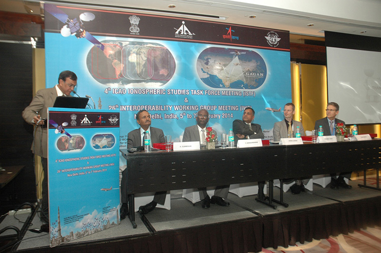
The 26th Satellite Based Augmentation Systems (SBAS) Interoperability Working Group (IWG) took place in New Delhi, India on February 5–7.
The 26th SBAS Interoperability Working Group (IWG) was introduced by V. Somasundaram, board member of the Airport Authority of India.
Among its achievements was to converge on a standard message definition for one of the channels — known as L5 — of the planned second-generation SBAS systems, which will utilize dual-frequency, multi-constellation signals.
“Two solutions had been put forward, one by ESA based on work by European industry and one from the U.S. Federal Aviation Administration and Stanford University,” explains ESA’s Didier Flament, co-chair of the IWG.
“A single definition coordinated between both bodies has been presented, combining the benefits of both solutions. The formal IWG review and approval loop has now been started with the objective of finalizing it for September’s IWG meeting.
“The aim is to have it ready to submit to the official international SBAS standardization bodies — the International Civil Aviation Organization and the Radio Technical Commission for Aeronautics — as soon as October.”
The meeting also marked the significant progress made by Indian’s own SBAS system GAGAN, which underwent its final stability test last summer, followed by its safety certification in December.
At this point GAGAN was declared certified for non-precision approach users , followed by its safety-of-life service being formally offered to civil aviation users on 14 February.
GAGAN has been jointly undertaken by the AAI and the Indian Space Research Organisation, intended to provide improved accuracy, availability and integrity necessary to enable users to rely on satnav signals for all phases of flight – from en route as well as approach to all qualified airports within the GAGAN service area.
SBAS services worldwide
EGNOS is an operational precursor to Europe’s Galileo global satnav system.
GAGAN is the fourth certified SBAS to enter servicer worldwide. Europe has the European Geostationary Navigation Overlay Service (EGNOS), which was designed and built by ESA then turned over for operation by the European Satellite Service Provider, ESSP, overseen by the European Global Navigation Satellite System Agency (GSA) — both of whom also participated in the meeting. ESA retains responsibility for the future evolution of EGNOS.
The U.S. has the Wide Area Augmentation System (WAAS), developed and operated by the Federal Aviation Administration, with an extension over Canada called CWAAS (Canadian WAAS). WAAS celebrated its 10th anniversary of operational life last July.
Japan has the Multi-functional Satellite Augmentation System (MSAS), developed and operated by Japan’s Civil Aviation Bureau. Japan is currently discussing plans to merge this capability with their new home-grown satnav system, QZSS.
Along with GAGAN, the meeting also covered the progress made by the other SBAS systems under definition or development — the Russian SDCM, Chinese SNAS and Korean K-SBAS.
The follow-up IWG meeting is due to take place in September in Tampa, Florida.
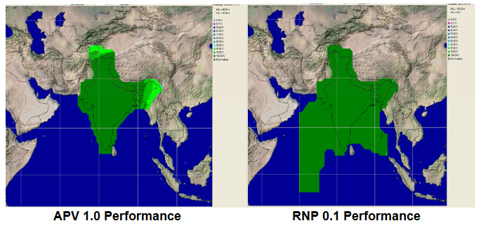
Planned GAGAN service coverage for the two different service levels (RNP0.1 and APV1). GAGAN has been jointly undertaken by the Airport Authority of India and the Indian Space Research Organization, ISRO, to achieve smooth transition to satellite-based navigation and seamless air traffic management across continents. GAGAN is designed to provide improved accuracy, availability and integrity necessary to enable users to rely on GPS for all phases of flight, from en route through approach for all qualified airports within the GAGAN service volume. More precisely it is aimed to provide Non Precision Approach RNP0.1 service levels to the entire Indian Flight Information Region and Precision Approach APV1 service (equivalent to the current EGNOS Service) within a specified service volume within Indian land mass.
Tackling ionospheric interference
The New Delhi IWG took place concurrently with a related meeting, the ICAO’s 4th Ionospheric Study Task Force. This group has been tasked with the objective of developing region-specific models of ionospheric models to compensate for satnav signal interference or loss.
The ionosphere, the electrically sensitive outer shell of Earth’s atmosphere, can be perturbed by solar activity. And because satnav signals pass from space by Earth they can then be disrupted in turn. Equatorial regions see the greatest disturbance, including signal delay or ‘scintillations’ making signals unstable.
The aim is to develop reliable ionospheric models to compensate for these effects, particularly for equatorial SBAS regions, such as India. ESA is contributing with data from its worldwide Monitor network, gathering data to improve future EGNOS performance and potentially support further geographical extension.
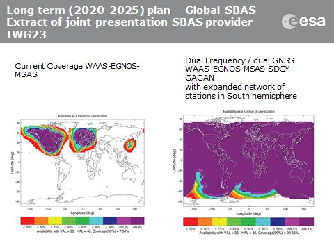
Comparing current worldwide SBAS coverage — based on WAAS, EGNOS and MSAS — to the situation envisaged for 2020–25: near-global coverage based on WAAS, EGNOS, MAAS, SDCM and GAGAN, with an expanded network of stations in the southern hemisphere, based on a common dual-frequency/dual satnav standard being finalized by the SBAS IWG.
Northrop Grumman has been selected by AgustaWestland to supply the LCR-110 Inertial Reference System for the new AW609 TiltRotor aircraft.
Northrop Grumman Corporation has been selected by AgustaWestland, a Finmeccanica company, to provide flight-critical inertial instruments on the new AW609 TiltRotor aircraft undergoing civil certification through the Federal Aviation Administration.
The LCR-110 Inertial Reference System and the LCR‑300A Air Data Attitude Heading Reference System have been chosen as standard inertial navigation products for the advanced AW609 TiltRotor. The LCR‑110 features a high-performance, fiber-optic gyro-based inertial measurement unit and an advanced micro-electromechanical system (MEMS) triad accelerometer. The system offers hybrid navigation via GNSS data, in addition to aircraft autonomous integrity monitoring for GPS signal integration and integrity checks. These features are essential for precise Required Navigation Performance flight operations.
The LCR‑110 evolved from the successful, longstanding LCR‑100 product family that has been selected for numerous rotorcraft and fixed-wing platforms.
The systems were developed by Northrop Grumman Navigation and Maritime Systems Division’s subsidiary in Germany, Northrop Grumman LITEF.
“This suite of combined equipment provides critical flight control and navigation data to help the aircraft achieve required availability, precision and the highest levels of integrity,” said Eckehardt Keip, managing director for Northrop Grumman LITEF. “Our products enhance precision navigation operations, improve safety margins, save weight and volume, and provide attractive commercial advantages.”
The LCR‑300A is being introduced after several years of independent research and development. The system’s MEMS gyro provides advanced attitude heading reference system performance in combination with a magnetic sensing unit. It also features directional gyro mode, which minimizes magnetic compass errors.
The digital air data computer module, which is embedded in the LCR‑300A, was developed by Curtiss-Wright Corporation’s Defense Solutions division. It weighs less than 0.9 pound, yet contains the pneumatic sensors and processing electronics to generate the complete International Civil Aviation Organization air data parameter set. The module is designed using the latest high stability, low drift pressure transducer technologies, providing exceptional repeatability and reliability, Northrop Grumman said.
The twin engine, fly-by-wire AW609 TiltRotor combines the benefits of a helicopter and fixed-wing aircraft into one platform. The aircraft is a natural choice for civil and para-public roles, flying above adverse weather conditions at 25,000 feet in a comfortable and pressurised cabin at twice the speed and the range typical of helicopters.
Qualcomm Technologies, Inc., has added the Qualcomm Gobi 9×30 platform with extended lifecycle support to Snapdragon Automotive Solutions, enabling advanced telematics and infotainment features for next-generation systems.
The announcement was made at Mobile World Congress, being held this week in Barcelona, Spain.
Based on Qualcomm Technologies’ fourth-generation LTE platform, the Gobi 9×30 supports LTE Advanced Category 6 with up to 300 Mbps downlink data rates, enabling broadband vehicle connectivity for enhanced navigation, Wi-Fi hotspot, infotainment content and telematics services.
Gobi 9×30 builds upon Qualcomm Technologies’ LTE modem technology for automotive, the Gobi 9×15, and promises to enable a superior next-generation GNSS engine and fast 3G and 4G LTE connections worldwide, while supporting broad multi-region coverage in a single SKU with the Qualcomm RF360 front-end solution. The Gobi 9×30 is based on the 20-nm technology node with support for global carrier aggregation deployments up to 40 MHz in both LTE FDD and TDD modes. The Gobi 9×30 features broad multi-mode capability with support for all other major cellular technologies, including LTE TDD networks in China.
In addition to 3G/LTE connectivity, the new platform is pre-integrated with QCA6574, a dual-stream 802.11ac Wi-Fi and Bluetooth 4.1 chipset designed to simultaneously support in-car Wi-Fi hotspot functions and Bluetooth profiles. The QCA6574 also supports DSRC (dedicated short-range communications), a technology required to comply with future regulation recently announced by the National Highway Traffic Safety Administration (NHTSA) to increase safety through vehicle-to-vehicle (V2V) communication. The Gobi 9×30 and QCA6574 will also be pre-integrated with Qualcomm Technologies’ recently-announced automotive-grade Snapdragon 602A processor.
“The need for high-speed connectivity in the automobile is driving ever-increasing data rates as well as greater integration of features and technologies,” said Kanwalinder Singh, senior vice president of business development for Qualcomm Technologies, Inc. “Adding Gobi 9×30 to our technology leading LTE lineup offers to our module, Tier-1 and automaker customers the flexibility of a global SKU with next-generation LTE features including data rates up to 300 Mbps and carrier aggregation. The Gobi 9×30 sets a new bar for features and integration: 20 nm technology node; support for both LTE FDD and TDD modes; built-in next-generation GNSS engine; pre-integration with Snapdragon 602A; and pre-integration with QCA 6574, supporting 802.11ac, BT 4.1, and DSRC.”
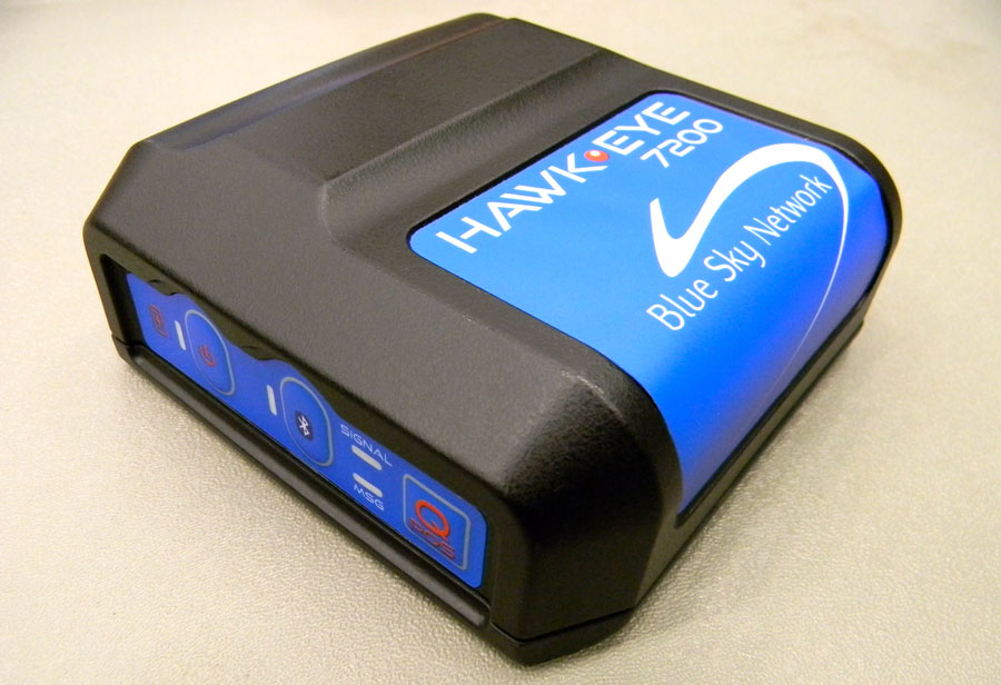
Blue Sky Network’s HawkEye 7200 Portable Tracking Solution.
Blue Sky Network has released the portable HawkEye 7200 with geofencing. The Hawkeye 7200, released in September 2013, is a small mobile device designed specifically for Iridium and GNSS satellite tracking of aviation, land/mobile or marine assets. The company will demonstrate its new AVR (advanced variable response) geofencing capabilities at the upcoming HAI Heli-Expo tradeshow in Anaheim, California, February 25-26.
“Advanced variable response or AVR delivers functionality and utility one level beyond traditional geofencing alarms or alerts. It allows the asset manager or geofence designer to set a conditional response for what happens or does not happen when an aircraft, vehicle, or vessel is in, or out of a geofenced area,” explains John Peterson, Blue Sky Network’s vice president of Business Development. “For example, position reporting frequencies could be turned off when an asset is at its home base, resume normal reporting after leaving the base, and increase reporting frequency when entering regions considered more dangerous. AVR gives asset managers more control, ultimately making fleet management easier, safer, and less expensive.”
In addition to AVR, the HawkEye 7200 offers three significant advantages over traditional satcom asset tracking devices
An all-in-one design including internal long-lasting lithium ion battery and dual Iridium and GNSS antenna;
true concurrent multi-national GNSS for faster, more accurate positioning; and
Bluetooth connectivity using Blue Sky Network’s custom APP for iPhone and iPad, facilitating easy messaging and custom form transmission from Apple devices.
The HawkEye 7200 portable satcom solution works directly with Blue Sky Network’s cloud-based web portal SkyRouter. Skyrouter is a secure online website that provides tracking and management of globally dispersed assets.
Boatracs, Kannad, McMurdo and TSi have combined to form McMurdo Group, a single-vendor provider of end-to-end search and rescue, maritime domain awareness solutions.
McMurdo Group has announced a suite of Automatic Identification System (AIS) survival solutions for enhanced collision avoidance and man overboard (MOB) response in the U.S. recreational boating market. The offerings include AIS beacons, transponders, receivers and software.
AIS is an automatic tracking system used on boats and ships that identifies and tracks nearby AIS-equipped vessels and devices to help avoid collisions. AIS transponders send and receive critical navigation information – such as vessel identification numbers, vessel type, position, course and speed – and graphically display a map of the surrounding vessels and area. AIS receivers are often used in conjunction with AIS-capable computer software for similar tracking and monitoring purposes.
In the event a person with an AIS MOB beacon falls overboard, an AIS signal from the beacon is activated. This signal is then sent to AIS receiving devices where the location of the individual in the water can be pinpointed using GPS positioning and presented on graphical chart maps.
The Smartfind M5 has an on-screen beacon location indicator and audible alarm that is triggered to accelerate rescue efforts. It also has a “buddy list” feature that can identify the specific individual needing MOB assistance. For larger fleets, the McMurdo Group AIS Alarm Notification System extends graphical mapping, alarm notification and messaging capabilities to shoreside fleet management operators.
The McMurdo Group AIS product suite includes the following:
AIS Search and Rescue Transponders (SART) or Beacons
Smartfind S5 – a compact, lightweight, waterproof (to 10 meters) AIS SART with high-visibility buoyant carry-off bag ideal for use on life rafts or survival crafts.
Smartfind S10 – a personal, waterproof (to 60 meters) AIS Man Overboard (MOB) device with built-in flashing light and used by individuals or as an additional device to complement a yacht’s on-board flare pack.
Smartfind S20 – a compact AIS MOB device with integrated light for use in a lifejacket.
AIS Transponders and Receivers
Smartfind M5 AIS Class A Transponder – the industry’s first AIS Class A transponder with color display and AIS MOB and AIS SART alarm with crew list functionality to aid in MOB recovery.
Smartfind M10 AIS Class B Transponder – typically used for smaller vessels, charter boat operators or where the additional features of an AIS Class A transponder are not required (includes an a 30 day data logger).
Smartfind M15 AIS Receiver – economical AIS receiver for all recreational vessels.
AIS Software
PC Viewer – Graphical software package ideal for individual vessel operators (included with the Smartfind M5, M10 and Smartfind M15 products).
AIS Alarm Notification System – Vessel Monitoring System with integrated AIS MOB Alerts and Messaging typically used for ship-to-shore communications.
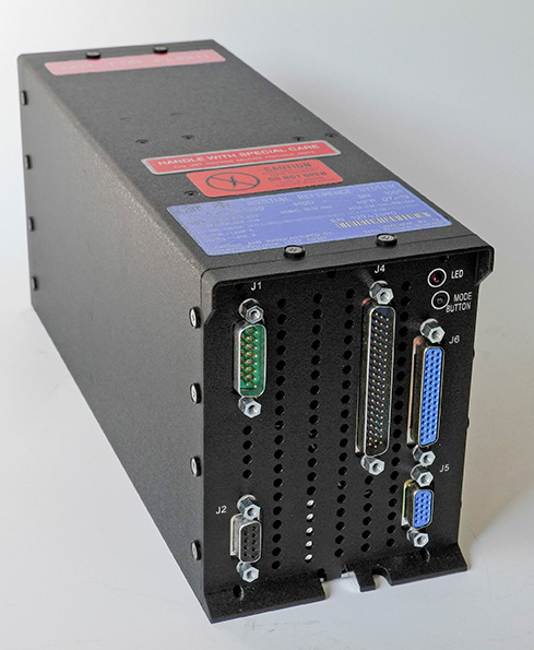
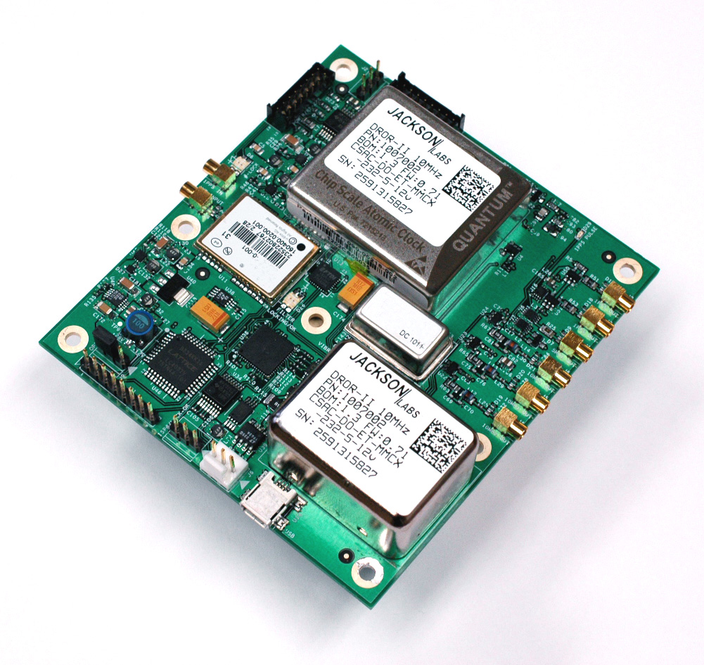
Jackson Labs Technologies, Inc., a designer and manufacturer of GPS, timing and frequency equipment, is offering the DROR-II, a 10-MHz/5-MHz/1-PPS GPS-Disciplined Atomic Frequency and Timing Reference (GPSDO).
The DROR-II is a ruggedized frequency and timing reference with a Cesium Vapor Atomic Oscillator followed by a precision SC-cut Crystal Double-Oven Oscillator and an actively vibration-compensated VCXO oscillator, with specific emphasis on ultra low phase noise performance under extreme vibration and acceleration such as could be encountered in aircraft, tracked vehicles, and wheeled vehicles.
The DROR-II unit is optimized for operation in high-vibration and high-acceleration environments that require ultra-low phase noise performance and high frequency stability under extreme conditions. The DROR-II combines the strengths of three different on-board oscillators to provide an overall performance that has not been achievable with legacy products, at a steady-state power consumption of less than 3.85W, the company said.
The DROR-II uses a GPS receiver to provide long-term phase and frequency accuracy of the built-in CSAC atomic oscillator which is followed by an SC-cut, Double Oven OCXO (DOCXO) for very high short-term stability and low phase noise, which is itself followed by a three-axis electronically vibration-compensated crystal oscillator for ultra-low-noise under high vibration. Using these four signal sources cascaded to each other allows unmatched Phase Noise and Short Term Stability (ADEV) while also providing long-term atomic holdover, very fast warmup, and long-term phase-lock to UTC. Short term stability of 1E-012 (1ppt), and phase noise floors of -162dBc/Hz are achieved. Frequency stability over 24 hours is better than 5E-013 (0.5ppt) typically when locked to GPS.
The DROR-II supplies three isolated 10-MHz Sine Wave outputs, two CMOS 1PPS, and one 5-MHz output that is phase-synchronized to UTC via the internal GPS receiver. DROR-II contains a 50-channel WAAS/EGNOS/MSAS-enabled GPS receiver that provides support for avionics systems through integrated three-axis gyro-accelerometers and a -160-dBm GPS tracking capability. DROR-II power requirements are less than 3.85W steady-state, and only a single supply of between 11.0V to 32V is required. Support for an external LCD display is standard.
The unit can be monitored and controlled by an RS-232 port or a USB port via industry standard SCPI-99 Commands (GPIB commands), and is capable of generating numerous NMEA-0183 output sentences for easy integration into existing infrastructure. The DROR-II can be ordered with various OCXO options and with different temperature ranges.
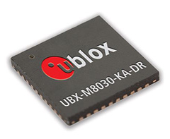
u-blox has introduced its next-generation semiconductor technology dedicated to advanced in-dash navigation, emergency call (including eCall, a European rapid response initiative, and ERA-GLONASS, Russia’s Government Accident Emergency Response System), usage-based insurance, road-pricing, and stolen-vehicle recovery systems.
The UBX-M8030-Kx-DR chip integrates 3D Automotive Dead Reckoning (3D ADR) technology, which enables it to calculate a vehicle’s position, speed, and elevation in areas of poor or no satellite visibility, a common scenario in high-density urban environments, stacked highways, or parking garages.
Here is a two-minute YouTube video demonstration.
“Drivers expect car navigation systems to be fast, accurate, and work everywhere, regardless of satellite visibility. As cities expand, construction of more tunnels, multi-level overpasses and park garages is increasing,” said Thomas Nigg, VP Product Marketing at u‑blox. “Our solution meets this challenge head-on; regardless of satellite visibility, our 3D ADR chip shows movement in three dimensions to maintain continuous and accurate positioning in tunnels, stacked highways, multi-level or underground parking facilities.”
The technology aids traditional GNSS navigation systems such as GPS, GLONASS and BeiDou by blending them with individual wheel speed, gyroscope and accelerometer information to maintain accurate 3D positioning even when satellite signals are completely lost.
The UBX-M8030-Kx-DR chip is self-calibrating to compensate for sensor aging and temperature effects. It is compatible with virtually all vehicles and drive trains (i.e. front-, rear-, all-wheel drive), and supports a variety of sensor combinations. Sensor information can be derived from the vehicle’s sensors for the most cost-efficient implementation, or from external sensors for after-market solutions. The chip is AEC-Q100 qualified and is produced in ISO/TS Automotive certified production sites.
The chip requires minimum host integration or customization resulting in no risk, low cost, and fast time-to-market, u-blox said. Installation is uncritical thanks to automated software calibration. 3D ADR is accurate even at low speeds.
The chip allows for easy testing, simple and modular production set-up, and minimal BOM. The chip comes in a 40-pin QFN package measuring only 5 x 5 mm and includes I2C, SPI, UART and USB interfaces.
Connected vehicles can help to mitigate crashes on busy urban streets.
The U.S. Department of Transportation’s (DOT) National Highway Traffic Safety Administration (NHTSA) announced today that it will begin taking steps to enable vehicle-to-vehicle (V2V) communication technology for light vehicles. This technology would improve safety by allowing vehicles to “talk” to each other and ultimately avoid many crashes altogether by exchanging basic safety data, such as speed and position, ten times per second, the agency said.
“Vehicle-to-vehicle technology represents the next generation of auto safety improvements, building on the life-saving achievements we’ve already seen with safety belts and air bags,” said U.S. Transportation Secretary Anthony Foxx. “By helping drivers avoid crashes, this technology will play a key role in improving the way people get where they need to go while ensuring that the U.S. remains the leader in the global automotive industry.”
DOT research indicates that safety applications using V2V technology can address a large majority of crashes involving two or more motor vehicles. With safety data such as speed and location flowing from nearby vehicles, vehicles can identify risks and provide drivers with warnings to avoid other vehicles in common crash types such as rear-end, lane change, and intersection crashes. These safety applications have been demonstrated with everyday drivers under both real-world and controlled test conditions.
The safety applications being developed provide warnings to drivers so that they can prevent imminent collisions, but do not automatically operate any vehicle systems, such as braking or steering. NHTSA is also considering future actions on active safety technologies that rely on on-board sensors. Those technologies are eventually expected to blend with the V2V technology. NHTSA issued an Interim Statement of Policy in 2013 explaining its approach to these various streams of innovation. In addition to enhancing safety, these future applications and technologies could help drivers to conserve fuel and save time.
V2V technology does not involve exchanging or recording personal information or tracking vehicle movements. The information sent between vehicles does not identify those vehicles, but merely contains basic safety data. In fact, the system as contemplated contains several layers of security and privacy protection to ensure that vehicles can rely on messages sent from other vehicles and that a vehicle or group of vehicles would be identifiable through defined procedures only if there is a need to fix a safety problem.
In August 2012, DOT launched the Safety Pilot “model deployment” in Ann Arbor, Michigan, where nearly 3,000 vehicles were deployed in the largest-ever road test of V2V technology. DOT testing is indicating interoperability of V2V technology among products from different vehicle manufacturers and suppliers and has demonstrated that they work in real-world environments.
In driver clinics conducted by the Department prior to the model deployment, the technology showed high favorability ratings and levels of customer acceptance. Participants indicated they would like to have V2V safety features on their personal vehicle.
“V2V crash avoidance technology has game-changing potential to significantly reduce the number of crashes, injuries and deaths on our nation’s roads,” said NHTSA Acting Administrator David Friedman. “Decades from now, it’s likely we’ll look back at this time period as one in which the historical arc of transportation safety considerably changed for the better, similar to the introduction of standards for seat belts, airbags, and electronic stability control technology.”
NHTSA is now finalizing its analysis of the data gathered as part of its year-long pilot program and will publish a research report on V2V communication technology for public comment in the coming weeks. The report will include analysis of the Department’s research findings in several key areas including technical feasibility, privacy and security, and preliminary estimates on costs and safety benefits. NHTSA will then begin working on a regulatory proposal that would require V2V devices in new vehicles in a future year, consistent with applicable legal requirements, Executive Orders, and guidance. DOT believes that the signal this announcement sends to the market will significantly enhance development of this technology and pave the way for market penetration of V2V safety applications.
“We are pleased with the direction NHTSA is taking in terms of V2V technology,” said Greg Winfree, Assistant Secretary for Research and Technology. “The decision to move forward comes after years of dedicated research into the overwhelming safety benefits provided by a connected vehicle environment.”
V2V communications can provide the vehicle and driver with 360-degree situational awareness to address additional crash situations — including those, for example, in which a driver needs to decide if it is safe to pass on a two-lane road (potential head-on collision), make a left turn across the path of oncoming traffic, or in which a vehicle approaching at an intersection appears to be on a collision course. In those situations, V2V communications can detect threats hundreds of yards from other vehicles that cannot be seen, often in situations in which on-board sensors alone cannot detect the threat.
NHTSA has worked in close partnership in this research both with other DOT agencies, including the Office of the Assistant Secretary for Research and Technology and the Federal Highway Administration, and with several leading auto manufacturers and academic research institutions, who have invested significant resources into developing and testing V2V technology. The collaboration of government, industry and academia is critical to ensure V2V technology’s interoperability across vehicles.
Singapore-based Miclyn Express Offshore (MEO), a provider of offshore support vessels across South East Asia, Australia and the Middle East, has awarded Veripos a five-year contract for provision of high-precision GNSS positioning services in support of its fleet of 27 ships.
Under the terms of the contract, Veripos will provide MEO’s fleet with Veripos Ultra Precise Point Positioning (PPP) service designed to deliver decimeter-level accuracies globally along with associated integrated mobile receivers. Among the first vessels assigned to utilize the service and equipment are MEO’s new 2,000 dwt platform supply vessels, MEO Ranger and MEO Resolution, both of which have been equipped with LD5-GG2 receivers. Meanwhile, four older MEO vessels have been similarly configured to receive Veripos Ultra service.
Commenting on the latest contract award, Walter Steedman, Veripos chief executive officer, said it further consolidated the company’s continuing leadership for provision of precise GNSS positioning services for offshore applications throughout the region and beyond.
Miclyn Express Offshore employs more than 1,400 shore-based personnel and seafarers.
Honda Motor Co. is joining an alliance of companies that will work with Google Inc. on technological innovations for inboard automotive information networks, such as GPS, according to The Asahi Shimbun. Honda will be joining Audi AG, General Motors, and Hyundai Motor Group in the Open Automotive Alliance. The alliance plans to incorporate Google’s Android operating system into automotive communications systems.
Google has also indicated interest in the development of driverless cars.
Toyota Motor Corp., meanwhile, established a joint venture with Microsoft Corp. three years ago to develop information technology for Toyota’s next-generation vehicles. The technology allows for updating map data and other services for the GPS in Toyota vehicles, as well as track stolen vehicles.
The Director General of Civil Aviation (DGCA) of India certified on December 30 the GAGAN system to RNP0.1 (Required Navigation Performance 0.1 Nautical Mile) service level, according to The Hindu.
Now aircraft equipped with Satellite Based Augmentation System (SBAS) receivers will be able to use GPS-Aided Geo Augmented Navigation (GAGAN) signals in Indian airspace for en route navigation and non-precision approaches without vertical guidance.
Mission control centers, along with associated uplink stations, have been set up at Kundalahalli in Bangalore. Another control center and uplink station are in Delhi. A top official of the AAI said one of the Reference Stations has been housed outside the premises of the Thiruvananthapuram airport. The reference stations pick up signals from the orbiting GPS satellites. The measurements are immediately passed on to the mission control centers that then work out the necessary corrections that must be made. Messages carrying those corrections are sent via the uplink stations to the satellites in geostationary orbit that have the GAGAN payload.
The availability of the GAGAN signal in the country’s air space will bridge the gap between European Union’s European Geostationary Navigation Overlay Service (EGNOS) and Japan’s Multi-functional Satellite Augmentation System (MSAS) coverage areas.
The SBAS consists of 15 Indian Reference Stations, three Indian Navigation Land Uplink Stations, three Mission Control Centers, three Geo-Stationary Navigation Payload in C and L bands and with all the associated software and communication links.
GAGAN will provide augmentation service for GPS over India, the Bay of Bengal, South East Asia and the Middle East expanding up to Africa.