Vatn Systems — a defense technology company specializing in autonomous underwater vehicles (AUVs) for the U.S. military, its allies and commercial clients — has launched its new S12 AUV-torpedo product line. The company also opened a new manufacturing facility in Rhode Island, which is capable of producing up to 2,000 vehicles annually.
AUV-torpedo product line
Vatn Systems’ new 12.75-inch diameter AUV can operate as both a torpedo and an AUV in modular configurations. The Skelmir S12 is designed for deployment from submarines, surface vessels, or aircraft, and can support a range of missions, including torpedo operations, sensor delivery and electronic warfare.
The Skelmir S12, in its AUV configuration, has completed its first exercise. The initial production run has been sold to government customers, with deliveries expected this year. The torpedo variant is scheduled for manufacturing and delivery in 2026.
The company’s new manufacturing facility leverages patent-pending modular design and vertical integration techniques, enabling rapid production at a scale previously unseen in the underwater vehicle market.
Vatn recently partnered with Palantir to digitize its manufacturing process and provide AI-driven insights to accelerate the production of AUVs built in the new facility, which is expected to reach full production capability in July 2025.
A 2019 RAND report for the U.S. Navy concluded that autonomy could still be in the distant future. The Navy should take care that a number of claimed autonomy applications could be more aspirational than practical, the report stated, with the applications nowhere near to operational capability. The authors wrote that huge investments may be required to achieve autonomous naval weapon systems, not only in autonomy.
Around the world in recent years, most armed forces and many advanced technology companies, along with government agencies, have been investing in AI and automation. Perhaps now, just six years later in 2025, we already are looking foward to unmanned vehicles that display not just fundamental autonomy, but also quite advanced “auto-capability.”
In the world’s water
The U.S. Navy (USN) has been operating a number of unmanned surface vessels (USV) over the past several years. In a 2023/2024 Pacific Fleet exercise, four USV models (Sea Hunter, Sea Hawk, Mariner and Ranger) were mostly operated autonomously. Ranger has a small bridge manned only for harbor maneuvers.
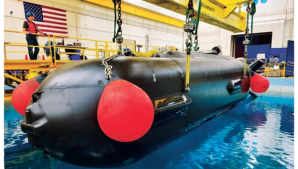
An Orca extra large UUV (XLUUV) is tested in a tank. With a range of 6,500 nautical miles, the submarine can perform long missions. Its navigation system features a Kalman-filtered inertial unit supported by Doppler velocity logs and depth sensors. Photo: Boeing
The USN has unmanned autonomy programs for large, small and underwater vehicles. The Orca submarine program is slated to consist of five 51-foot-long vehicles, and includes variants fitted with an added 30-foot payload section. To operate for several months underwater, it is likely that a similar degree of autonomy has been incorporated. ORCA surfaces regularly and can be given new routing if required.
Saildrone’s autonomous research vessel (Photo: Saildrone)
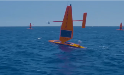
Other types of vessels collect ocean and seafloor data. The environmentally friendly Saildrone can operate independently — we could say autonomously — for more than a year. The Saildrone company, based in Alameda, California, contracts out its USVs, providing its technology to agencies and governments and taking on the risks of ocean surveying to acquire valuable data. Saidrones are equipped with satellite communications, GNSS navigation, weather sensors and sub-surface sensors.
Wheels on the road
Autonomy applications on land are dominated by commercial self-driving cars, Tesla being the leading manufacturer in the U.S. However, full autonomy is still a considerable way from being ready. At the full-autonomy level, known as Level 6 in the auto industry, the vehicle does all the driving, including obstacle avoidance, under all conditions, without any geographic limitation. Nevertheless, we appear to have progressed from basic manual control (Level 0) to somewhere around Level 3, where the vehicle is largely aware of its environment, and does most of the driving. Even so, human monitoring and control are still required.
Tesla’s autopilot technology in its Model S and Model X electric vehicles could be referred to as an advanced driver assistance system — or as Tesla calls it, “Full Self-Driving (Supervised)” — and is reported to handle emergency steering and braking, autonomous steering, lane changing, vehicle following, curve negotiation, and automatic parking. Autopilot sensor inputs are provided by 12 ultrasonic sensors and eight cameras providing a 360° field of view.
Tesla Autopilot intelligence can identify more than 250 traffic signs 50 countries, including turn signs and speed limits. It can identify and interpret traffic lights and road markings, and decide what to do when coming across things such as traffic cones and pedestrians.
Nevertheless, Tesla’s have been involved in quite a few accidents, the cause of which has been analyzed to be mostly a lack of driver attention (supervision), and in a number of cases, a failure of the autonomous system to recognize unusual road conditions.
Another company, Leo Drive, specializes in providing scalable software and hardware solutions, offering an end-to-end, one-stop service for integration of autonomous systems. Its mission is to make autonomous technology more accessible and widely adopted across various industries.
For its autonomous test vehicle, Leo Drive is using the Ellipse-D, a dual-antenna RTK inertial navigation system (INS) from SBG Systems. The company chose the Ellipse-D for its accuracy, reliability, and advanced features — all essential for autonomous vehicle development and testing. The Ellipse-D INS was integrated into Leo Drive’s, a passenger car converted for autonomous operations.
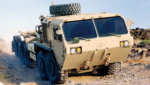
Oshkosh Defense integrated autonomous technology onto Palletized Load System vehicles as part of the Expedient Leader Follower program. Photo: Oshkosh Defense
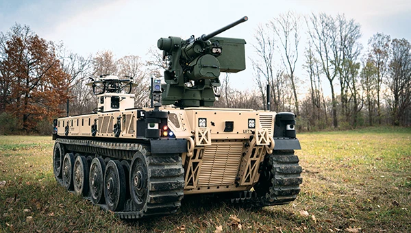
The U.S. Army has been using automation in its weapon systems for some time. How much autonomous behavior, of which these systems are truly capable, may be difficult to determine. The General Atomics Reaper unmanned aerial vehicle (UAV) is largely controlled over long-distance satellite links by operators in control stations. It’s possible that the same set up is true of most of the Army’s automated weapons — probably motivated by the need to avoid systems independently determining their own targets and firing without human confirmation.
It’s difficult to determine just what army programs are underway, other than to acknowledge that programs have been launched in the past. There doesn’t appear to be any open, clear indication of the degree of autonomy to be included. A couple of programs have produced at least visible hardware, but how much or little human control is involved is unclear.
Taking flight
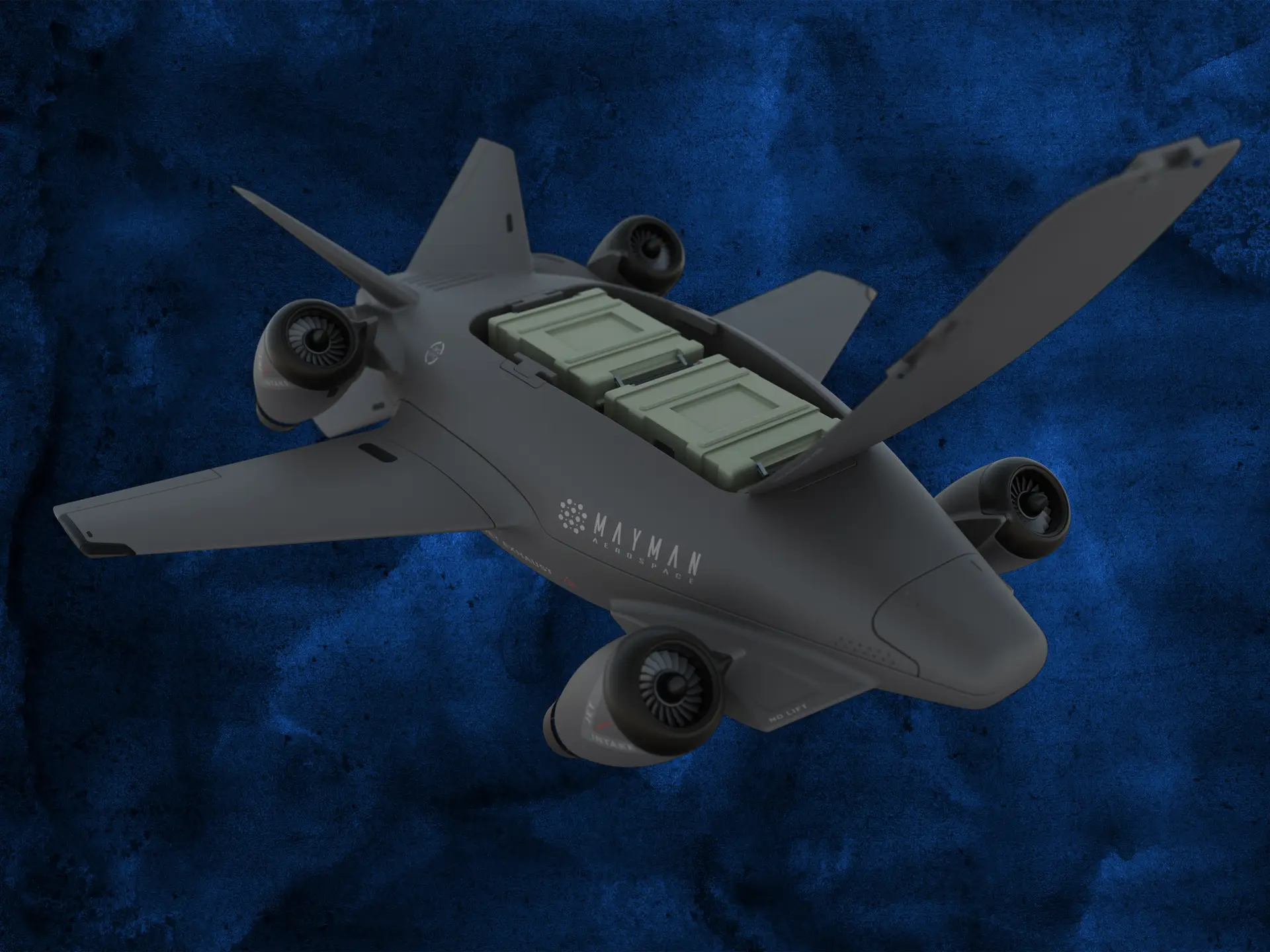
Up in the air, new autonomy contender Mayman Aerospace is offering the Razor, a jet-powered vertical take-off and landing (VTOL) UAV. Development of Razor is funded by private investment and U.S. Department of Defense contracts.
The RAZOR VTOL with gimbled jet pods passed tests at a military base in California in September 2024. Photo: Mayman Aerospace
Razor is imbued with a degree of AI that enables autonomous decision-making, as well as navigation. Its autonomous AI brain — the SkyField flight-control system — navigates independently in a GPS-denied environment, possibly involving ground beacons and eventually integrating with battlefield management systems. With a 5- to 6-foot-long airframe and sculpted shape, the aircraft presents a low radar cross section and has a degree of stealth to assist in the penetration of enemy defenses. Its top speed of 500 mph provides new options for both military and commercial applications, according to Mayman.
Razor also can aid disaster recovery, rescue operations, and the delivery of urgently needed life-saving cargo.
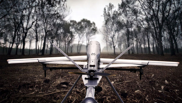
Many VTOL unmanned aircraft have struggled with the transition from vertical to horizontal flight. On its first vertical lift-off and climb-out on four jet engines, Razor paused briefly at altitude. Then its jet pods tilted slightly toward horizontal before the aircraft went directly into horizontal flight. An earlier flying testbed may have assisted the development of transition software, perhaps with a boost from machine learning.
Designed for deliveries, the EHang 216 heavy cargo, 16-rotor unmanned aircraft can carry a payload of 551 pounds over almost 22 miles with a top speed of 80 mph, according to the EHang company. The UAV is fully autonomously operated while being monitored over a 4G/5G data link at a manned control center. The system has an automatic fail-safe mode in which the UAV will return to base if the communications link goes down or if battery power drops too low.
EHang also uses a redundant design, with two GPS receivers and double rotors, ensuring a low likelihood of failure during a delivery run.
More In development
So while land vehicle autonomy is moving forward — with Tesla cars and Army vehicles that apparently can take control with close human monitoring — we still have some distance to go to achieve fully independent autonomous behavior on the road.
The Ehang 216 heavy-cargo UAV EHang 216L is designed for deliveries, including life-saving ones. Photo: Ehang video screenshot
Autonomous applications on the sea are more common, with U.S. Navy applications showing substantial progress. Still, precise navigation in crowded harbors remains under human control. Humans are still watching and monitoring, ready to intervene should military or commercial UAV applications make untoward execution errors.
We will continue to follow developments of significant autonomy programs such as the U.S. Air Force Collaborative Combat Aircraft (CCA), a new type of uncrewed weapon system. The CCA and other programs are maintaining high investment levels, so it’s possible that we may see full autonomy fielded quite soon. Perhaps then our belief in its capability will become fully justified.
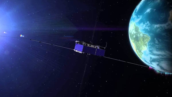
Sierra Space, a commercial space and defense technology company, has successfully completed another demonstration of its resilient GPS (R-GPS) technology for the U.S. Space Force. This achievement marks the third major milestone for the program, which is designed to enhance the resilience of GPS infrastructure against threats such as jamming and spoofing. The recent demonstration included early integration of R-GPS satellite technology using FlatSat flight software and hardware subsystem testing, as well as successful communication with ground software systems.
The R-GPS effort is part of a broader initiative by the U.S. Space Force’s Space Systems Command to develop smaller, more cost-effective GPS satellites. Sierra Space was awarded a Quick Start contract in September 2024 to produce design concepts for these satellites, aiming to rapidly bring advanced technology to the national security space sector. The company’s progress comes just six months after the program’s inception, highlighting its ability to accelerate technology development in response to evolving defense needs.
GPS technology is integral to both civilian life and military operations, supporting applications that range from smartphone navigation to critical defense activities. As adversarial threats become more sophisticated, the need for resilient GPS systems has grown. The R-GPS program addresses this by planning to augment the existing GPS architecture with a network of smaller satellites, which would provide additional layers of security and rapid deployment capabilities.
The latest testing milestone demonstrated the flow of commands and telemetry between Sierra Space’s ground software and a ground stations service provider, establishing that the technology can operate effectively between orbit and ground-based facilities. The FlatSat testing format, where satellite components are evaluated while laid out flat, allowed for early integration of flight software and hardware subsystems.
Inertial Labs, a VIAVI Solutions company, has released the IMU-H100, a micro-electromechanical systems inertial measurement unit (IMU) designed to improve tactical guidance and navigation for UAVs, short-range missiles, precision-guided munitions and a range of commercial applications.
As technology for unmanned vehicles advances and safety considerations take precedence, both military and commercial sectors are increasing their adoption of IMUs, which are critical for navigation and control systems. An IMU can track angular velocity and linear acceleration using MEMS gyroscopes and accelerometers. These devices are now considered essential for guidance, navigation, orientation and stabilization, especially in short- and medium-range flight control systems. Their applications extend to autonomous vehicles operating on land, at sea and in aerospace and defense sectors.
The IMU-H100 is a tactical-grade unit that features accelerometers and gyroscopes on all three axes. It offers a gyro bias of 1° per hour and an accelerometer bias of 1 mg. The unit measures 5 cubic inches and weighs 160 g. According to the company, the IMU-H100 surpasses comparable products in data rate, measurement range, stability and repeatability, even under challenging conditions such as vibration, shock, high acceleration, spinning, temperature changes and acoustic noise.
The U.S. Army has selected AEVEX Aerospace to participate in the Launched Effects-Short Range Special User Demonstration, an initiative aimed at advancing the Army’s integration of sophisticated uncrewed systems to improve battlefield effectiveness. AEVEX will present its Atlas Group II launched effect during the demonstration, a lightweight and agile system engineered for precision missions that directly support frontline troops. The Atlas system reflects AEVEX’s commitment to developing innovative technologies that address the Army’s evolving operational threats and mission requirements.
Throughout the demonstration, soldiers from various Army branches — including field artillery, infantry, and aviation — will operate the Atlas system to refine tactics, techniques and procedures. Their hands-on feedback will play a critical role in shaping how the Army employs launched effects in the future, influencing both requirements and operational strategies.
A new prototype sensor developed by the NATO Communications and Information Agency has completed a significant round of testing, marking a step forward in NATO’s electromagnetic warfare capabilities. The sensor, GANDALF 4, underwent a series of tests at an advanced anechoic chamber operated by the NATO Support and Procurement Agency. This facility serves as a controlled environment for precise calibration and detailed performance assessment of the sensor’s antenna array, which is critical for ensuring the system’s accuracy and reliability.
GANDALF 4 was developed by specialists at the agency’s Joint Intelligence, Surveillance and Reconnaissance Centre. The system is designed to detect, classify and locate deliberate attempts to interfere with or manipulate GNSS signals. GNSS jamming and spoofing are becoming more frequent and sophisticated, posing challenges to NATO’s operational readiness and resilience. The development of GANDALF 4 is designed to enhance situational awareness in contested electromagnetic environments.
The recent testing phase focused on evaluating the antenna performance of the sensor. Collaboration between the agency’s Electromagnetic Warfare and Surveillance team and the procurement agency’s Ground Based Defence group played a central role in the campaign, facilitating knowledge transfer and improving efficiency, according to the team.
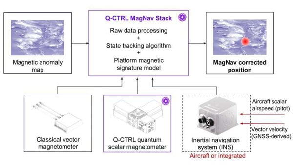
A team of researchers at Q-CTRL, a quantum infrastructure software company based in Sydney, Australia, has completed a successful demonstration of a new quantum navigation system called Ironstone Opal. The group described the system’s operation and performance in a paper posted to the arXiv preprint server.
GPS technology is widely used for navigation in both civilian and military vehicles and aircraft. However, the increasing reliance on GPS has highlighted its vulnerability to outages, which can leave drivers stranded, force pilots to rely on outdated methods and complicate the deployment of military assets. These concerns have driven efforts worldwide to develop robust backup systems or alternatives to GPS.
Q-CTRL’s Ironstone Opal is designed as a backup navigation system and, according to the research team, can deliver accuracy up to 50 times greater than existing GPS backup systems in certain scenarios. The system leverages quantum sensors that are highly sensitive to variations in the Earth’s magnetic field. Because the magnetic field differs depending on geographic location, these sensors can precisely determine an object’s position by reading the field and using artificial intelligence-based software to generate geographic coordinates similar to those provided by GPS.
The research team shared that unlike conventional systems, Ironstone Opal is passive, meaning it does not emit signals that could be detected or jammed by adversaries. The system’s software is designed to filter out noise from vehicles or aircraft carrying the sensors, and the hardware is compact enough for installation in cars, trucks, UAVs and aircraft.
Field trials conducted by Q-CTRL included both ground vehicles and aircraft. The results showed that Ironstone Opal outperformed a high-end inertial navigation system, a standard GPS backup, by up to 50 times in ground tests and by at least 11 times in airborne tests. These trials demonstrated the system’s ability to maintain high accuracy under a range of environmental conditions, altitudes, and maneuvers, with positioning uncertainty as low as 0.01% of the total distance traveled in the best cases.
Q-CTRL’s approach combines proprietary quantum magnetometers with advanced denoising and map-matching software, allowing the system to detect subtle magnetic “landmarks” in the Earth’s structure. The technology is designed to be resilient, unjammable, and suitable for integration into a wide range of platforms, including autonomous vehicles and commercial aircraft.
The United States Navy’s Naval Air Systems Command (NAVAIR) has awarded TrustPoint a $1.2 million Small Business Innovation Research Phase II contract. The funding supports the initial delivery and demonstration of TrustPoint’s C-band GNSS service-enabled receivers for the U.S. government. TrustPoint is collaborating with Hexagon U.S. Federal and NovAtel, both part of Hexagon.
This project combines TrustPoint’s C-band services with NovAtel’s GNSS receiver technology, aiming to advance resilient positioning, navigation and timing solutions for military use. The partnership draws on extensive experience in military-grade GNSS equipment and services, and represents a significant step in developing technology that can operate reliably in challenging operational environments.
The contract highlights the increasing importance of frequency and orbital diversity for future navigation and timing needs. With Hexagon as a key partner, TrustPoint is positioned to address the Department of Defense’s evolving requirements for assured PNT, supporting mission continuity even in contested environments
Advanced Navigation, an Australia-based company, is expanding its presence in the United States by actively recruiting military veterans. The company aims to leverage the unique expertise of former service members to enhance its mission-critical technologies and address the growing demand for assured positioning, navigation and timing (APNT) capabilities across defense, aerospace and critical infrastructure sectors.
Wayne Prender, former U.S. Army captain and head of global defense at Advanced Navigation, believes warfighters-turned-technologists are central to this mission.
“Veterans bring more than technical expertise; they understand firsthand the urgency and complexities of navigation in contested spaces. Their experience directly informs how we design, test and implement solutions, delivering capabilities that genuinely enhance mission outcomes and warfighter safety,” said Prender.
The company recruits veterans with operational backgrounds in submarines, special operations, aviation and electronic warfare to apply their expertise to APNT applications — including unmanned systems, advanced radar, precision strike platforms and secure battlefield communications. Advanced Navigation’s veteran-led business development team collaborates closely with system integrators, program offices and military end users to deliver tailored APNT solutions that meet rigorous performance standards.
Sierra Space has successfully demonstrated its Resilient GPS (R-GPS) technology for the U.S. Space Force (USSF). This milestone, achieved in collaboration with General Dynamics Mission Systems, involved generating all GPS navigation signals required for the R-GPS mission. The technology seeks to address the growing need for resilient GPS systems capable of countering threats such as jamming and spoofing, which pose risks to the current GPS infrastructure.
GPS technology is integral to modern life, supporting civilian applications from smartphone navigation to critical military operations. However, as adversarial threats become increasingly advanced, there is a pressing need to enhance GPS resilience. To tackle this challenge, the USSF’s Quick Start program is focused on integrating smaller, cost-effective satellites into the existing GPS framework. These satellites would provide a rapidly deployable layer of protection against emerging threats, according to the USSF.
The demonstration evaluated hardware, firmware, and software performance, including the generation of P(Y), M-code and C/A signals at L1 and L2 frequencies. These capabilities ensure that R-GPS satellites can produce accurate and secure navigation signals compatible with devices used globally.
Sierra Space was awarded an R-GPS contract by the USSF Space Systems Command in September 2024 to develop design concepts for smaller and more affordable satellites. Following an internal Systems Requirements Review later that year, the company has now demonstrated its technological capabilities within months of the program’s inception.
The Federal Communications Commission (FCC) has issued a Notice of Inquiry (NOI) seeking public input on positioning, navigation and timing (PNT) systems and policies. While GPS is crucial for the United States’ economic and national security, its dependency as a single point of failure renders it vulnerable to disruption or manipulation by adversaries. Recognizing this vulnerability, leaders such as President Trump, Chairman Cruz, and Senator Markey have advocated for developing alternative systems to ensure resilient PNT capabilities.
PNT data is integral to countless military, public safety, agricultural, and commercial activities. Given the dependence of the American economy and national security on GPS as the sole PNT source, the agency states that the U.S. government is prioritizing efforts to create robust backup systems that can safeguard essential functions in the event of GPS signal disruptions.
The FCC’s NOI examines how the agency can foster the development of alternative and complementary PNT. It seeks feedback on various emerging PNT technologies being developed by broadcasters, wireless operators, satellite constellations and startups utilizing FCC-licensed spectrum. The inquiry also addresses tradeoffs among these technologies based on performance, scalability, geographic coverage, durability, cost and commercialization potential.
The Commission aims to establish a comprehensive record to guide its actions in enhancing GPS resilience and promoting alternative PNT solutions. Potential measures include regulatory changes, public-private partnerships, testbeds, Innovation Zones and other initiatives.
Two PNT-related petitions are currently under FCC consideration. NextNav has proposed allocating approximately $5 billion worth of spectrum to collaborate with telecom providers in establishing a PNT network. Meanwhile, the National Association of Broadcasters (NAB) has suggested adopting a new TV signal format capable of transmitting PNT information without requesting additional spectrum allocation. Insights from the NOI will help inform decisions on these proposals.
The FCC’s inquiry reflects growing concerns about reliance on GPS as a single system for PNT data. By fostering alternatives like terrestrial networks or broadcast-based solutions such as NAB’s Broadcast Positioning System, the Commission seeks to strengthen national resilience against potential disruptions to critical infrastructure and services.
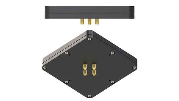
Inertial Labs, a VIAVI Solutions Inc. Company, has introduced the M-AJ-QUATRO anti-jamming antenna system, designed to ensure assured positioning, navigation and timing (A-PNT) in GNSS-challenged environments. The system incorporates advanced Controlled Reception Pattern Antenna (CRPA) technology and digital processing capabilities, making it suitable for applications ranging from military operations to commercial aviation.
PNT services are increasingly critical for various sectors, including transportation, telecommunications, artificial intelligence, hyperscale data centers, energy, finance and defense. As GNSS jamming and spoofing threats grow, government agencies and industry leaders are working to address these challenges. For instance, the Federal Aviation Administration and Naval Air Warfare Center Aircraft Division are expediting approval processes for CRPA technology to enhance aviation safety and counter GPS interference.
The M-AJ-QUATRO supports the L1, L2, and L5 GNSS bands and offers robust interference suppression capabilities. Its adaptive digital nulling feature automatically mitigates jamming signals with over 34dB+ suppression in the export-free version and over 45dB+ suppression in the export-controlled version. Additionally, the system can identify and locate sources of interference through its jammer direction-finding capability, improving situational awareness.
It is compatible with multiple GNSS constellations to provide comprehensive global coverage. It employs dual FPGA-based encryption and anti-spoofing technologies for secure signal processing and data integrity. Built to meet stringent military standards like MIL-STD-810G and MIL-STD-461F, the M-AJ-QUATRO is engineered to withstand extreme conditions, making it an ideal solution for defense and aerospace applications.