Rx Networks, Inc., a GNSS data services company, announced the availability of TruePoint.io precise location services on Qualcomm’s Snapdragon 8 Gen 1 and Snapdragon 888 5G Mobile Platforms. TruePoint.io integration empowers Android smartphones to achieve enhanced location accuracy down to a meter or less – something previously only seen with high-grade receivers.
With enhanced location accuracy, superior user experience for such use cases as rideshare, micro-mobility, health and fitness and lane-level requirement applications can now be realized. The enablement of reliable meter-level location accuracy on mobile phones will unlock the potential of location-based services and open the door for other innovative and unique use cases. The limitations of a standalone GNSS chipset no longer become the barrier to pursuing the vision of connected ecosystems reliant on location.
TruePoint.io enables scalable, reliable, and affordable ways to leverage high-precision location on smartphones powered by Snapdragon mobile platforms. Rx Networks’ global coverage, including China, gives smartphone OEMs the advantage of a single GNSS corrections vendor that works across all continents.
“Rx Networks provision of GNSS data services for accurately positioning smartphones using Snapdragon mobile platforms will enable meter-level location accuracy almost everywhere smartphones can connect to a terrestrial cellular network,” said Francesco Grilli, Vice President, Product Management at Qualcomm Technologies, Inc. “Meter-level location accuracy is poised to improve smartphone user experiences and spur the creation of exciting and innovative services for businesses and consumers.”
TruePoint.io is scheduled to be available on Snapdragon mobile platforms initially in China in Q4 2022 and globally in H1 2023.
Photo: Bill Oxford / iStock / Getty Images Plus / Getty Images
TCI International, a CommTech company, announced Spectrum Surveyor, a graphical interface solution that enables radio frequency regulators to proactively monitor and manage sensors, mobile, fixed and transportable stations across their networks. The software helps regulators solve today’s spectrum management and scarcity challenges. Spectrum Surveyor is already being used by regulators in Europe.
Spectrum Surveyor helps regulators determine who is transmitting on 5G frequencies before establishing a transmission. It identifies ‘white spaces’ by conducting long-term monitoring campaigns, observation, and investigation into any existing gaps. The software enables those already operating in the 5G space to monitor more efficiently and with fewer resources, increasing the utilization of the existing monitoring network.
The new software addresses the evolving digital landscape, delivering automated and centralized monitoring of the spectrum and collecting real-time data on spectrum intelligence in the form of 3D visualizations. Spectrum Surveyor also allows teams to automate routine tasks among groups of monitoring stations, and subsequently produce reports of the spectrum’s activity, immediately flagging any issues within the network.
“In recent years with 5G adding complexity, regulators have experienced a significant increase in the number of stations needed to monitor the spectrum and the progressive intricacy of the digital landscape,” said Ann Bustamante, vice president of Business Development, Spectrum Monitoring Services (SMS) TCI. “This has led to additional considerations in the monitoring and reporting process, such as the need to centralize and simplify network control and data collection to be able to quickly identify the precise moment and location of a problem and to address it.”
Hexagon’s Safety, Infrastructure & Geospatial division announced the addition of artificial intelligence to HxGN Connect, Hexagon’s real-time incident center as a service solution.
HxGN Connect provides crime and operations centers with real-time views of different data sources, collaboration channels to coordinate across teams and the ability to add new participants and channels as needed. The AI capabilities autonomously analyze diverse data types from incidents, assets, cameras, units, alarms and more, issuing proactive notifications and alerts based on observed trends and deviations.
Having access to diverse information and intelligence in real-time enables police, emergency management, transportation and other organizations to evaluate a situation and deploy resources faster, while continuing to coordinate and dynamically respond as situations change.
“Some organizations operate in silos, without access to data or the ability to act on it,” said Kalyn Sims, Chief Technology Officer, Safety & Security, Hexagon’s Safety, Infrastructure & Geospatial division. “[HxGN Connect] breaks down silos within departments and across jurisdictions, and it mines data in real-time to deliver insights. The result is quicker and better responses to incidents and emergencies.”
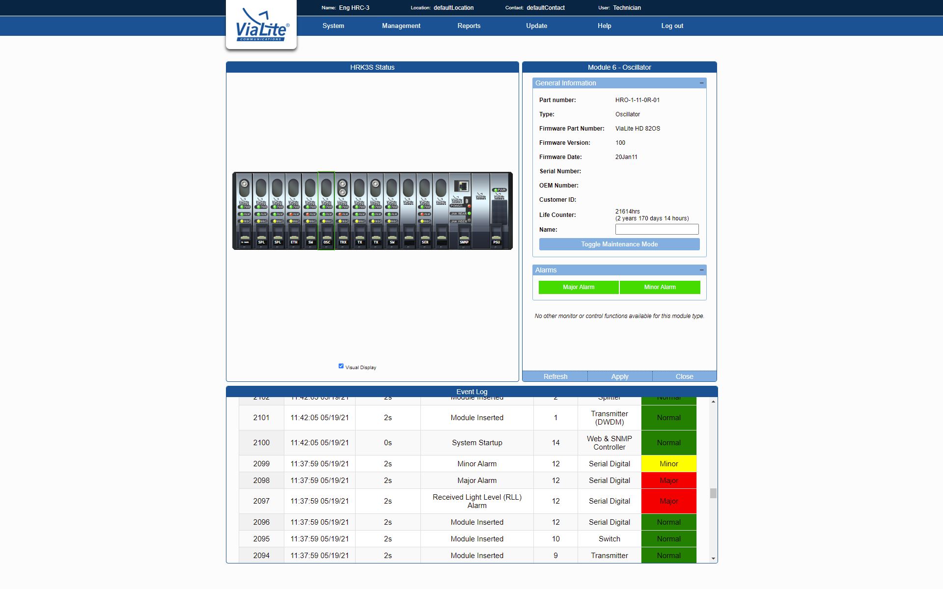
Femtocell cellular base stations used by Global Medical Response (GMR) in their Dallas, Texas, offices are receiving high-accuracy GPS location and timing signals from RF-over-fiber links from ViaLite Communications.
The GPS signals help GMR provide emergency quality medical care at a moment’s notice, primarily in the areas of emergency and patient relocation services in the United States and around the world.
The Local Integrated GPS Splitter. (Photo: ViaLite)
The highly reliable system consists of a ViaLite GPS Link that sends the GPS and timing signals from the rooftop antenna down an optical fiber to a Local Integrated GPS splitter situated in the building. The splitter then distributes the timing data to multiple femtocells.
“The efficiency of ViaLite’s signal distribution techniques is second to none, and in this emergency support application, when action at a moment’s notice can be vital, our equipment’s reliability and performance are crucial,” explained Craig Somach, ViaLite sales director.
A monitoring and control module is built into the GPS splitter. (Photo: ViaLite)
Use of the high-tech splitter, which features a built-in monitoring and control module, also eliminates the need to install multiple antennas on the rooftop, avoiding the appearance of an antenna farm.
“As a first-time customer, we found the deployment was as smooth and simple as ViaLite had promised,” said Dan Cottom, senior manager of communication systems at GMR. “The GPS distribution is working great.”
The Indian government is pushing smartphone makers to sell devices that receive NavIC signals along with GPS.
India originally stated NavIC would be required in smartphones sold starting in January 2023, according to Reuters, but strong reaction from smartphone manufacturers Apple, Xiaomi and Samsung apparently caused the government to push back or remove the deadline.
A deadline of January 2023 would not allow enough time for smartphone makers to integrate NavIC-enabled receivers to their devices. Steps include redesign, securing parts, testing and assembly. Many smartphones sold in India by the companies are economy-level devices priced under US$200.
The three tech giants met with government officials, seeking an extended target date of 2025, Reuters reported.
However, India’s Ministry of Electronics & IT issued a statement via Twitter :
A media report has claimed citing a meeting that mobile cos were asked to make smartphones compatible with NavIC within months. This is to clarify: (1) No timeline has been fixed. (2) The cited meeting was consultative; and (3) the issue is under discussion with all stakeholders.
NavIC (Navigation with Indian Constellation) is the operational name for the Indian Regional Navigation Satellite System (IRNSS) developed by India’s space agency for military and commercial purposes. NavIC consists of eight satellites that cover the Indian mainland and the region extending up to 1,500 km from its boundaries.
“NavIC can help in navigation on land, air, sea and also in disaster management,” Science & Technology Minister Jitendra Singh said in a press release. “NavIC satellites are placed at a higher orbit than the GPS of United States. NavIC satellites are placed in geostationary orbit (GEO) and geosynchronous orbit (GSO) with an altitude of about 36,000 km; GPS satellites are placed in medium earth orbit (MEO) with an altitude of about 20,000 km.”
“NavIC uses dual-frequency bands, which improves accuracy of dual-frequency receivers by enabling them to correct atmospheric errors through simultaneous use of two frequencies,” Singh said. “It also helps in better reliability and availability because the signal from either frequency can serve the positioning requirement equally well.”
Celestia UK has won a €800,000 European Space Agency (ESA) contract to develop an innovative positioning, navigation and timing(PNT) solution based on LEO satellite constellations for 5G networks and applications.
The contract was granted under ESA’s Navigation, Innovation and Support Programme (NAVISP).
Malachy Devlin, CEO, Celestia UK
Celestia’s LEO-SYN+ project is intended to boost the reliability and performance of GNSS. It will use low-Earth-orbit (LEO) satellite signals of opportunity to provide a resilient position and time reference for 5G networks and improve the robustness of GNSS signals.
It includes development of a PNT receiver compatible with multi-GNSS constellations and LEO signals of opportunity, as well as testing of the solution in 5G networks. A prototype receiver will validate the product design and the technology development, paving the way for additional applications of the technology to other critical infrastructures after the initial ESA NAVSIP roll-out.
To deliver the ambitious project, Celestia UK is partnering with Heriot-Watt University, which brings extensive knowledge in satellite communications and digital signal processing, and The Scotland 5G Centre, the national center for accelerating deployment and adoption of 5G and realizing its economic and societal potential for Scotland.
“It is a great benefit for the business to have won an ESA NAVSIP contract,” said Malachy Devlin, CEO of Celestia UK. “We are looking forward to collaborating with ESA and our partners to unlock the potential to improve the resilience of 5G networks with our PNT solution.”
Ian Sharp, head of Business Development, The Scotland 5G Centre, added,“The Scotland 5G Centre is providing businesses access to 5G services through a national network of innovation hubs, under its 5GConnect Programme. It is well known that 5G will support higher data throughput and interactive services through reduced latency. However, 5G will also provide new possibilities for positioning, navigation and timing (PNT). Use of advanced antennas and positioning over satellite will be critical for outdoor applications where precise navigation is essential to meet safety requirements for the likes of drone navigation and autonomous vehicles. We are delighted to be working alongside Celestia UK, supporting the innovative LEO-SYN+ project, which will utilise our cutting edge 5G network.”
Onocoy has launched a project to provide a dense network of community-powered GNSS reference stations. Based on Web 3.0 and an innovative incentive program, onocoy’s project strives to ensure outstanding positioning data quality suitable for mass market applications such as drones, micro-mobility, robotic lawnmowers or autonomous vehicles.
In the past, ultra-precise GNSS navigation with real-time kinematics (RTK) was only available to high-end markets because of prohibitive costs. With increasing demand for higher accuracies and advances in receiver technology, along with the availability of new GNSS signals, RTK receiver prices have dropped, yet high correction service costs and insufficient business models for mass markets have limited large-scale application of RTK.
Onocoy’s project aims to provide scalable correction services by leveraging Web 3.0 methods and distributed ledger technology. Such technology will facilitate a decentralized approach to the number of GNSS reference stations, 20 times the density as exist now. Ultra-dense distribution of GNSS reference stations will allow global access to instant centimeter-level positioning.
“Utilizing Web 3.0 methods with distributed ledgers and smart contracts, onocoy is poised to create the world’s densest distribution of GNSS reference stations that will enable RTK positioning anywhere,” said Daniel Ammann, initiator of the onocoy project. “By applying an open governance system, the interests of all stakeholders are taken into account in a transparent manner, ensuring that the project effectively addresses the needs of the stakeholders.”
The project will enable users to have the highest quality in GNSS data thanks to rigorous data validation and an innovative incentive scheme for data miners, where high-quality data is rewarded. Costs will be kept at a minimum with cutting-edge technology implementation and the wide user base. As a result, users will have the freedom to shape their solution to fit their market’s needs.
From left: Yusuf Kıraç, Türk Telekom chief technology officer, and Net Insight CEO Crister Fritzson. (Photo: Türk Telekom)
Türk Telekom is using specialized GPS/GNSS-independent technology to provide critical time and frequency synchronization in its 5G network.
The technology — developed by Türk Telekom engineers with Net Insight — is expected to significantly reduce synchronization investment costs and increase service continuity in 5G. The companies did not reveal the details of their technology.
Türk Telekom, the pioneer of digital transformation in Türkiye, continues its efforts to shape the future with 5G and new generation technologies. Türk Telekom became the first operator in the world to implement the “Time Synchronization Transmission Solution,” implemented in cooperation with Net Insight, one of the world’s leading technology companies, on its network. This solution, which is the patented technology developed by Türk Telekom and Net Insight, will provide strategic superiority in network technologies.
Minimum end-to-end deviation throughout Turkey
The testing process of the GPS/GNSS-independent stable synchronization service for 5G has been successfully completed. Türk Telekom, which has installed the system at 20 locations in Turkey, will have a central synchronization network with high time accuracy, and will be able to offer synchronization service to 5G base stations.
While the highest time deviation value for 5G is 1,500 nanoseconds, the deviation value was measured at 5–45 nanoseconds in two different regions of Türkiye, according to the first data obtained from the Türk Telekom live network. The values revealed that sensitive time and synchronization information can be carried from Edirne to Hakkari, the entire length of Türkiye, with minimum deviation regardless of network equipment.
Solution to increase efficiency and save resources
“We became the first operator to implement the next-generation synchronization solution, developed together with Net Insight and leveraging patents of Turkish engineers, which is critical for 5G and beyond technologies on the live network,” said Yusuf Kıraç, Türk Telekom chief technology officer. “We see a significant potential in the global market for this innovative solution that will reduce costs and increase service continuity for mobile operators and all industries with critical time synchronization requirements.
“We can meet all these needs with this solution, which has a time deviation far below 1,500 nanosecond required for the synchronization need of 5G,” Kıraç continued. “We are proud to develop new satellite-independent solutions for operators and standardization organizations in the world.”
“We believe that this solution, which is operated on the Türk Telekom network for the first time in the world, will break new ground in 5G and have a high and significant market potential on a global scale,” said Net Insight CEO Crister Fritzson.
Important step for 5G and beyond
The new-generation time synchronization solution, which is not depending on GPS/GNSS satellites, offers unique advantages for transmitting phase and time synchronization over the network without the need to replace or update existing network equipment. With this technology, a fundamental solution to GPS/GNSS satellites’ signal interruptions and service losses — one of the biggest needs of operators who have switched to 5G — will be met, the companies said.
At the same time, the synchronization needs of 6G technologies — planned to begin global standardization studies in 2025 — will be met with the same solution.
The patented technology will be produced and marketed all over the world and will provide solutions for sectors such as telecommunications, energy and finance.
A roundup of recent products in the GNSS and inertial positioning industry from the September 2022 issue of GPS World magazine.
OEM
Receiver Upgrade
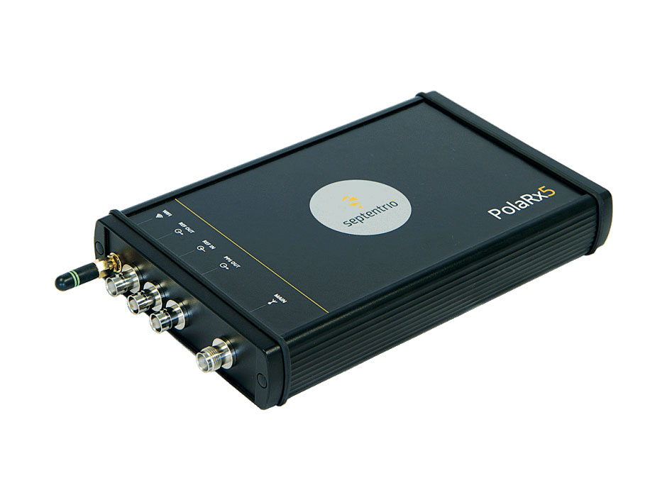
OSNMA anti-spoofing tech now on PolaRx5 GNSS reference receivers
Photo: Septentrio
Open Service Navigation Message Authentication (OSNMA) is now available on the high-end PolaRx5 reference receiver series. OSNMA offers end-to-end authentication on Galileo’s civilian signals, protecting receivers from GNSS spoofing attacks. OSNMA adds another layer of security to the receivers’ existing AIM+ anti-jamming and anti-spoofing technology. The PolaRx5 product range also now supports RINEX format versions 3.05 and 4.0.
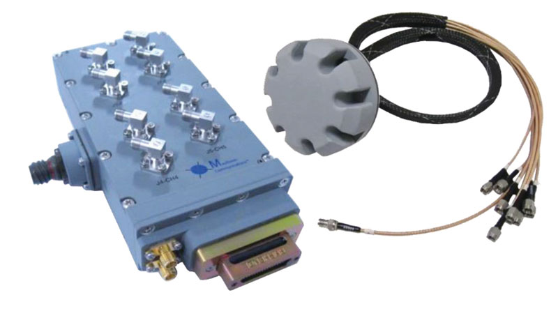
The MAGNA-F and MAGNA-I GPS anti-jam antennas provide simultaneous L1/L2 protection and can protect commercial and military GPS receivers on aircraft. The MAGNA products were developed with sponsorship by the U.S. Navy and further improved by the U.S. Army to support GPS protection requirements for air, sea and ground platforms, such as fixed-wing/rotary aircraft, ships, UAVs and tactical vehicles. The MAGNA-F uses a 3.5-inch-diameter controlled reception pattern antenna (CRPA) compatible with existing fixed radiation pattern antenna (FRPA) footprints. The MAGNA-I (NavGuard 730) is a high-performance yet small GPS anti-jam integrated solution with a 4.5-inch diameter FRPA-compatible footprint.
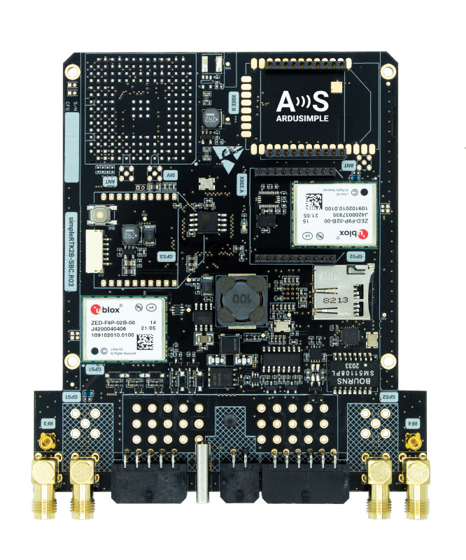
Centimeter-level GNSS for mass-market applications
Photo: ArduSimple
The SimpleRTK2B single-board computer (SBC) is built around up to three u-blox ZED-F9P high-precision GNSS receivers. It simplifies development of centimeter-level positioning solutions supporting real-time kinematics (RTK), making the technology accessible to broader audiences. The SimpleRTK2B-SBC was developed to make RTK technology as close to plug-and-play as possible. In addition to working as a stand-alone solution, customers can program their own applications with the company’s microPython API. The SimpleRTK2B-SBC delivers mechanical integration with centimeter position on three axes (heading, pitch and roll), outputting on NMEA, RTCM, RS232 and CANBus interfaces via Ethernet, Bluetooth, Wi-Fi and 2G/3G/4G communication. It offers configurable input/output and an inertial measurement unit.
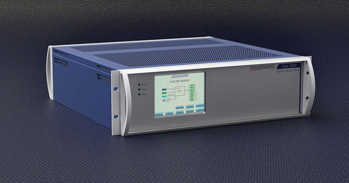
For assured positioning, navigation and timing (PNT)
Photo: ADVA
The OSA 3300-HP is a high-performance optical cesium clock with a 10-year lifetime compared to the five-year lifetimes of high-performance magnetic clocks. It provides the resilience required for PNT assurance in critical infrastructure and empowers service providers to deliver differentiated service-level-agreement timing offerings with integrated GNSS backup. The OSA 3300-HP has embedded Ethernet- and IP-based management as well as a user-friendly touchscreen graphical user interface.
With M-Code capabilities and upgrade paths for other GNSS systems
Photo: Collins Aerospace
NavHub-200M is a vehicle navigation system for the international market with military code (M-code) receiver capabilities. NavHub-200M provides assured positioning, navigation and timing (APNT) while improving overall resistance to threats to GPS, such as jamming and spoofing. Its message formats and signal modulation techniques ensure faster and more accurate performance for ground vehicles on the connected battlespace, while advanced security features prevent unauthorized access or exploitation. NavHub-200M also includes the open interface standards and sensor-fusion capabilities required for a GNSS upgrade path, such as that for Europe’s Galileo constellation, as well as the ability to interface with key vehicle sensors such as the inertial measurement unit (IMU) and odometer.
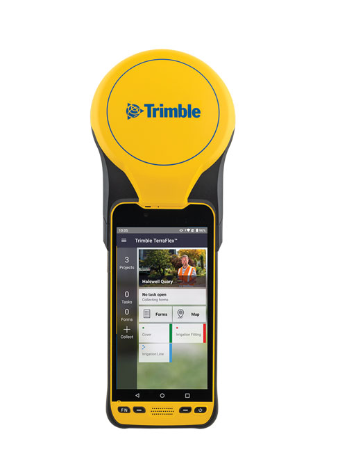
The Trimble TDC650 handheld is built for data collection, inspection and asset management activities. The rugged solution provides scalable high-accuracy GNSS positioning for professional field workflows, including apps such as Esri ArcGIS Field Maps and Trimble TerraFlex software. The TDC650 is scalable, allowing customers to choose their desired accuracy down to the centimeter level.
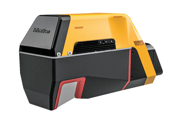
Powerful solution for manned and unmanned aircraft
Photo: YellowScan
The Voyager long-range lidar scanner has a wide field of view, with all points collected oriented toward the ground so there is no loss of points. In all, 1.5 million points per second will be usable. Voyager combines a Riegl VUX-120 laser scanner with a Trimble Applanix AP+ 50 AIR or Applanix AP+ 30 AIR GNSS-inertial board, providing a precision of 0.5 cm and an accuracy of 1 cm. Voyager’s detection and processing of up to 15 target echoes per laser pulse allows for excellent vegetation penetration. It has an extremely fast data-acquisition rate of up to 1,800 kHz, suitable for projects requiring the highest point density. The laser scanner’s specifications can be customized and can be combined with YellowScan’s software solutions.
Extends 3D Tiles Next workflow into Esri ArcGIS Pro
Photo: ArcGIS
The 3D Environments Add-In application for Esri ArcGIS Pro allows ArcGIS users to rapidly transform 3D Tiles Next data formats, such as One World Terrain, into ArcGIS Pro projects to create 3D scenes from 2D vector data and 3D models. The add-in leverages Presagis’ building templates and texture libraries that analysts use to create enhanced 3D visualizations of GIS environments, helping increase collaboration across the enterprise. The 3D Environments Add-In contains tools to create, transform and extract a wide variety of 3D formats to provide seamless interoperability between ArcGIS Pro and modeling and simulation applications. It is available on the Esri ArcGIS Marketplace.
Energy performance data helps tackle climate change
Photo: XMAP
Municipal geographic information system XMAP can now incorporate the energy-performance ratings of individual properties to help local authorities tackle climate change, improve housing standards, and ensure landlords comply with legislation. The Energy Performance Certificate (EPC) data layer uses a rating system similar to the one used on new appliances, ranging from A (very efficient) to G (inefficient). It allows tenants and house buyers to make informed decisions. In addition to a color-coded visualization of current ratings, the XMAP EPC layer contains enhanced analysis including generalized ratings and the potential for improvement. Bath and North East Somerset Council, UK (pictured), has embraced this resource and is looking at how the data can be used to raise housing standards.
The Elios 3 is a collision-tolerant drone equipped with a lidar sensor for indoor 3D mapping. The drone is powered by a new SLAM engine called FlyAware that lets it create 3D models as it flies. It also hosts a new version of Flyability’s software for inspectors, Inspector 4.0. The Elios 3 comes with an Ouster OS0-32 lidar sensor, allowing inspectors to collect data for the creation of survey-grade 3D models using Connect software from Flyability’s partner GeoSLAM. Protected by a cage, the Elios 3 has advanced collision-tolerance features that allow inspectors to fly it inside dangerous confined spaces such as boilers, pressure vessels and mines.
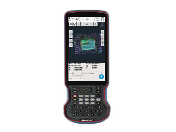
The R60 is a powerful handheld with an ergonomic design. It runs on Android 12 OS, providing a suitable workhorse for surveying professionals in the field. Survey Master field software works seamlessly on the R60, which features a Qualcomm 8-core processor for massive data processing. Its 64-GB memory allows ample data storage and enables the opening of CAD drawings in seconds. Other features include a QWERTY keyboard, a 5.5-inch sunlight-readable high-resolution screen, an IP67 rating (dustproof and waterproof), and a 9,000 mA Li-ion battery for more than 30 hours of continuous functioning.
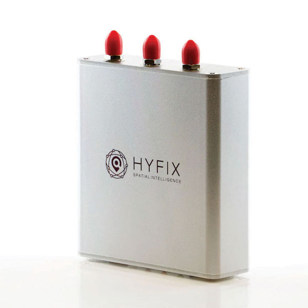
The Mobile Centimeter (MobileCM) Space Weather Station is a ready-to-use GNSS device that will act as a real-time kinematic (RTK) base station and collect space weather data. The device is pre-configured to securely connect with the Global Earth Observation Decentralized Network (GEODNET) using a home Wi-Fi network. The full four-constellation GNSS base station has built-in NTRIP server functionality and is packaged with a survey-grade triple-band roof antenna and required cables.
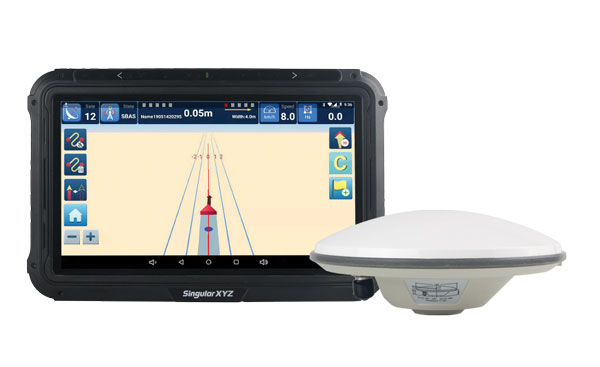
The SAgro10 GNSS guidance system is an entry-level guidance system for precision agriculture, providing users with higher navigation precision and higher productivity, which can be upgraded to an automatic steering system. Embedded with a high-precision GNSS module, the SAgro10 system tracks all four global constellations. For users with network coverage or a UHF base station, the system provides centimeter-level accuracy navigation in real-time kinematic mode. In the absence of base stations, the SAgro10 system provides sub-meter navigation accuracy in single-point smoothing mode. Compatible with most agricultural tractors, its components can be installed within 15 minutes. The 10-inch sunlight-readable touchscreen has a clear and simple graphic interface.
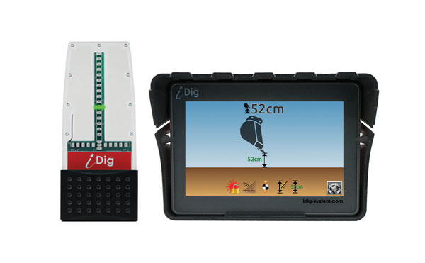
iDig 3D Connect is a solar-powered excavator guidance system with a GNSS receiver that can be removed and used as a rover, rather than permanently installed on the machine. 3D excavator guidance has seldom been used for small projects such as house foundations because of the need for a surveyor to stake out points and map a site. The removable receiver enables contractors to complete these tasks. The software provided creates a GNSS-generated site map, enabling precision digging relative to the area and making the process quicker, simpler and more eco-friendly than with 2D.
The Cloud Locator service takes data from LoRa Edge-enabled devices and uses Semtech’s LoRa Cloud Geolocation and Modem services for asset tracking both indoors and outdoors. It features built-in serverless technology and enables testing of ultra-low-power asset tracking on either a private or public LoRaWAN network. It is designed to work with trackers using Semtech’s LoRa Edge LR-series chips. The LR-series chips combine Wi-Fi and GNSS to obtain the latitude and longitude of devices in any indoor or outdoor location. Once configured on the service, together with Semtech’s LoRa wireless radio frequency technology for transmission to the cloud, customers can view the tracker location on a map in less than 15 minutes.
The Edge 1040 bike computer features solar charging and multi-band GNSS technology. Its multi-band GNSS receiver (GPS, GLONASS and Galileo) provides accurate positioning in challenging ride environments, such as dense urban areas or under deep tree cover. Advanced navigational tools help cyclists stay on track, such as turn-by-turn navigation and alerts that notify riders of sharp curves ahead. Route guidance and off-course notifications can be paused for exploring and turned back on for return to the original route. When using the Trailforks app, Forksight mode automatically displays upcoming forks in the route and where a rider is within a trail network.
Skydel 22.5 is a significant software upgrade to the Skydel simulation product line. It features advanced hardware-in-the-loop (HIL) testing solutions providing very low to zero effective latency. Enhanced visualization tools can monitor internal latency through real-time curves showing when the data is generated and sent to the RF signal. Users can also review the transmission of HIL packets for optimizing the entire network’s latency, checking its stability (jitter), and that data is available and used at the right time in Skydel. HIL testing is an essential step in the verification process of the model-based design approach because it involves all the hardware and software that will be used operationally.
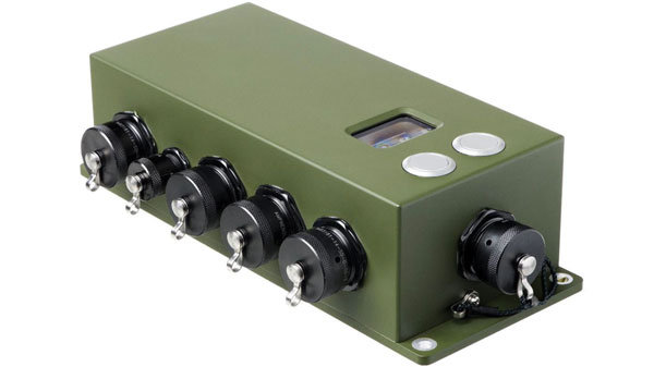
The Time-Loader is designed for defense and mission-critical applications, for deployment in environments where GNSS signals are denied or disrupted. It supports any ground, naval or airborne system that needs real time of day (TOD) and 1PPS external synchronization aligned to the UTC or GNSS. It generates a GPS L1 C/A code RF output as if the signal were coming from a live-sky GPS antenna. It provides full-constellation GPS output and is compatible with external GNSS receivers. Its GPS-disciplined oscillator (GPSDO) is the Microsemi MAC-SA53/55, which provides excellent UTC accuracy with outstanding hold-over rubidium clock performance. A self-contained, miniature GPS simulator provides real-time extremely accurate signals. The 18-channel full-constellation simulator stores location/time/date data in internal memory and stores complex vector data to simulate dynamic scenarios. The simulator also can be used to transcode NMEA or SCPI position/ velocity/time (PVT) data into GPS RF signals.
Vodafone and Topcon Positioning Group are developing a European precise positioning system, Vodafone GNSS Corrections, that will locate Internet of Things (IoT) devices, machinery and vehicles with a greater degree of accuracy than using individual GNSS.
Vehicles, scooters and robotic lawn mowers can be securely monitored in real time to within a few centimeters when connected to Vodafone’s global IoT network.
Vodafone GNSS Corrections will use technology from Topcon, which corrects inaccuracies from navigation satellite signals. Location accuracy is improved from a few meters to centimeters using Topcon’s dense European network of thousands of GNSS reference stations, especially when vehicles and devices are fitted with suitable antennas and receiver equipment.
Vodafone will offer a singular module configuration that can extend across national borders.
Vodafone is inviting select customers to join pilot customer trials in Germany, Spain and the UK, which will begin this month. The companies aim to test the service using a wide variety of devices connected to Vodafone’s global IoT network — one of the largest with more than 150 million connections — and its pan-European network covering 12 countries.
Pinpoint accuracy is critical to the mass adoption of vehicle-to-anything (V2X) technology used for driverless vehicles, autonomous machinery and robots. For example, e-bike riders could use Vodafone GNSS Corrections to provide details of their exact location and then alert other road users of their presence.
Vodafone GNSS Corrections also supports Vodafone’s efforts to improve V2X location accuracy, especially when sharing trusted data to help prevent unnecessary accidents and fatalities on Europe’s roads. As such, Vodafone is offering precise positioning as a complement to Vodafone’s new Safer Transport for Europe Platform (STEP) which allows entities to communicate with each other where no line of sight exists. Unveiled in March 2022, STEP has been successfully tested in Germany and the UK and will be made available via Vodafone Automotive and third-party apps later this year.
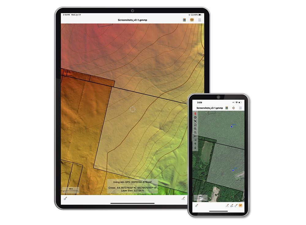
The Global Mapper Mobile Pro Module has always included the ability to connect to external GPS devices, but version 2.3 expands this to include support for any GNSS device that uses TCP/IP communication. Additionally, this mobile update provides Global Mapper analysis tools for volume calculation and viewshed for terrain data.
The mobile application of Global Mapper allows users to take the desktop functionality and existing data into the field for easy and accurate data collection and light processing. Since 2016, Global Mapper Mobile has been a user-friendly tool for capturing field data with portable iOS and Android mobile devices.
Version 2.3, available in both the free and Pro versions, adds many updates and improvements to the application, including the option to record and save voice memos to vector features and add multiple field-captured images to a feature. Autosave now prevents the loss of changes made to a map.
“Expanding user functionality in the field was the main focus of this release. Users of the base version of the application can utilize voice memos and the ability to save multiple photos to features for a more complete recording of field data,“ said Jeffrey Hatzel, Global Mapper Mobile product manager. “The Pro Module adds TCP/IP communication for external GNSS devices, expanding the list of compatible third-party devices. The addition of tools for volume calculation, viewshed analysis, and expanded projection support allows for even more workflows to be completed within the app.”