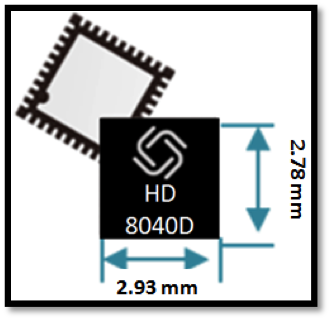
Allystar Technology Co. Ltd. has launched a multi-band, multi-GNSS system on chip, the HD8040 series, to help portable devices save size and weight. The HD8040 offered in wafer-level chip-scale packaging (WLCSP).
The HD8040 series of chipsets fully supports all civil signals on the L5 band, said Shi Xian Yang, Allystar high-precision product manager at Allystar. Besides GPS, other constellations with L1/L5 signals include Galileo, BeiDou, the Indian NavIC system and Japanese QZSS.
Besides L1 band, HD8040D supports L5/B2a/E5a signals, which are expected to have lower noise and be better in multipath mitigation mainly due to the higher chipping rate of L5 signals relative to L1 C/A code.
HD8041D supports IRNSS (NavIC), which makes it suitable for navigation in urban areas in India and the Middle East, where seven NavIC satellites have a higher elevation than both GPS and Galileo satellites. This means IRNSS (NavIC) would provide greater accuracy, precision and available measurements.
With the features of small size (3 x 3 millimeters) and low power consumption, the HD8040 series is suitable for smartphones, tablets and other portable devices.
The architecture integrates floating-point arithmetic units based on ARM CortexM4, 160 KB RAM, 32 KB backup RAM with VBAT, and 384 KB embedded Flash memory. Besides basic peripheral interfaces UART, I2C, SPI and GPIO, it supports the CAN interface for automotive applications, too.
Customer samples of the HD8040D and HD8041D are available now.
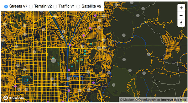
Advanced AI, robotics and autonomous vehicle services on Sprint’s dedicated IoT network will adapt to the real world using highly accurate, detailed and constantly refreshed maps.
Sprint and Mapbox are launching precision mapping technology with Curiosity IoT, allowing automated services that run on Sprint’s dedicated internet of things (IoT) network to move around the ever-changing world with pinpoint accuracy.
Smart machines, from drones to autonomous delivery carts, will be able to make fast location and routing decisions using highly detailed, accurate maps that are updated as the environment changes.
Sprint made the announcement this week at the Consumer Electronics Show being held in Las Vegas.
High Accuracy and Precise Detail with Live Maps. Mapbox offers what it calls a “live map”, a map built not from traditional data surveys months or years before, but from data collected from hundreds of millions of location-enabled sensors that feed back information about the world in real time.
Mapbox uses artificial intelligence (AI) to turn those massive data flows into a picture of real time transit paths that can be used for precise, up-to-date routing.
Image: Mapbox
Through its relationship with Sprint, Mapbox will leverage the inherent advantages of Curiosity IoT with 5G to take mapping to the next level. The network’s extreme bandwidth and low latency will allow Mapbox to collect higher volumes of richer data from the sensors, including high resolution video.
That data can be processed to identify and detect changes in the physical environment. Those changes are then incorporated into updated maps which can be distributed at scale to a wide variety of smart machines. The result is more accurate, more up-to-date maps that reflect the world in real time.
“Smart machine-based services need to be able to make immediate mobility decisions similar to the way a driver might react to construction, traffic or other obstacles on a street,” said Ivo Rook, senior vice president, IoT and product development at Sprint. “The launch of Mapbox’s precision mapping technology allows all intelligent machines to move at a level of precision never seen before. Our fully dedicated Curiosity IoT network and operating system — soon to be powered by Sprint’s mobile 5G connectivity makes this possible. From autonomous vehicles to advanced AI-based machines, precision mapping is a big step forward in making smart service models a reality for the immediate economy.”
“As maps guide new smart machines on IoT networks, you remove the human in the middle that used to compensate for differences between the map and the real world. Precision mapping services need to reflect the world as it is, at that precise moment so that those smart machines can travel safely and efficiently,” said Eric Gundersen, CEO of Mapbox. “Sprint’s Curiosity IoT network with mobile 5G provides platform services that make that real with high bandwidth, edge computing for object detection and data processing and super low latency.”
Curiosity IoT with 5G. Sprint 5G and Curiosity will create the new standard in IoT which features device data intelligence, over-the-air device management and chip-to-cloud security, the companies said.
When coupled with Sprint mobile 5G technology, Curiosity IoT’s dedicated, distributed and virtualized IoT core network is capable of supporting artificial intelligence, robotics, edge computing, autonomous vehicles and other IoT systems requiring extreme low-latency and high-bandwidth.
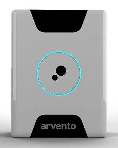
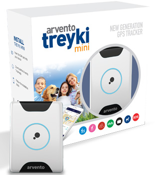
Treyki Mini relies on u-blox positioning and wireless communication technologies.
Photo: Arvento/u-blox
U-blox, a global provider of positioning and wireless communication technologies, is partnering with Arvento Mobile Systems, a Turkey-based fleet telematics company, to develop a compact people and asset tracking device with a long battery life.
The Arvento Treyki Mini has eight operating modes, including special settings for tracking children (with geofencing) and senior citizens (with an integrated fall sensor). It is also suitable for use in sports, racing and asset management. It can also be used as an emergency beacon.
The tracker has an onboard positioning receiver, and reports its location using an internal GSM/GRPS modem. It can operate for up to seven days from its 900mAh LiPo rechargeable battery before it needs to be recharged.
Photo: Arvento/u-blox
The Treyki Mini relies on the u-blox ZOE-M8Q concurrent multi-GNSS module to discover its location. This system-in-package (SiP) offering is 4.5 x 4.5 x 1.0 millimeters. It provides high accuracy thanks to its ability to receive 72 channels simultaneously, from up to three different GNSS constellations, the company said.
It also offers reliable positioning in challenging environments because it has a sensitivity of –167 dBm and is energy efficient.
Communications for the Treyki Mini are provided by the u-blox SARA-G340 dual-band GSM/GPRS module — its very low standby power of less than 0.90 mA helps extend the Mini’s battery life. The SARA-G340 module also supports firmware-over-the-air (FOTA) updates, enabling Arvento to continue to refine the Treyki Mini after production.
“The Treyki Mini is the result of a very close collaboration between Arvento and u-blox to optimize its size and power consumption,” said Özer Hıncal, general manager, Arvento. “We expect that the strong sense of partnership that evolved between our two companies during the development of the Treyki Mini will lead to further collaboration in the future, especially when it comes to telematics system solutions.”
The U.S. Federal Communications Commission (FCC) granted in part the European Commission’s request for a waiver of the commission’s rules so that non-federal devices in the United States may access specific Galileo signals. While private users were free to use the European GNSS, with this ruling entities such as telecommunications companies can now also use Galileo.
With today’s action, consumers and industry in the United States will now be permitted to access the E1 and E5 Galileo signals to augment GPS.
Since the debut of the first consumer handheld GPS device in 1989, consumers and industry in the United States have relied on the U.S. GPS to support satellite-based positioning, navigation, and timing (PNT) services that are integral to everyday applications ranging from driving directions to precision farming.
The order, approved Nov. 15, finds that Galileo is uniquely situated as a foreign GNSS system with respect to the U.S. GPS, since the two systems are interoperable and radiofrequency compatible pursuant to the 2004 European Union/United States Galileo-GPS Agreement.
Specifically, the order permits access to two of the Galileo system’s satellite signals — the E1 signal that is transmitted in the 1559-1591 MHz portion of the 1559-1610 MHz Radionavigation-Satellite Service (RNSS) frequency band, and the E5 signal that is transmitted in the 1164-1219 MHz portion of the 1164-1215 MHz and 1215-1240 MHz RNSS bands. These are the same RNSS bands in which the U.S. GPS satellite signals operate.
The order does not grant access to the Galileo E6 signal, which is transmitted over the 1260-1300 MHz frequency band, since this band is not allocated for RNSS in the United States or used by the U.S. GPS to provide PNT services.
The commission noted that granting access to the Galileo E6 signal could constrain U.S. spectrum management in the future in spectrum above 1300 MHz, where potential allocation changes are under consideration.
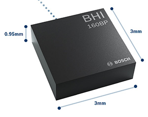
The BHI160BP position tracking smart sensor. (Photo: Bosch Sensortec)
Bosch Sensortec has released the BHI160BP, a position tracking smart sensor that uses integrated inertial sensors to improve GPS location tracking.
Bosch will exhibit the new sensor at Electronica Munich, Nov. 13-16.
When used with a GPS or GNSS module, the BHI160BP enables users to take full advantage of pedestrian position tracking with up to 80 percent saving in system power consumption compared with a typical GNSS-only solution, without compromising on accuracy, the company said.
Users benefit from greatly extended battery life and longer charging intervals for wearable applications such as smartwatches and fitness trackers as well as mobile devices such as smartphones.
The new position tracking approach is set to enable a new class of compact devices with even smaller batteries, Bosch claimed.
The BHI160BP tracks a person’s position by intelligently applying an inertial-sensor-based algorithm for pedestrian dead reckoning. To maintain accuracy, it calculates the user’s relative location based on data collected from the inertial sensors and then recalibrates itself every few minutes to obtain the absolute position provided by the GNSS/GPS module. This means that the GNSS/GPS module can be kept in sleep mode for most of the time, which drastically reduces a device’s power consumption and extends its operating time.
“Pedestrian position tracking is a crucial application for mobile applications; unfortunately, GPS modules can rapidly drain a device’s battery capacity — especially when the battery is as small as in wearable devices,” said Stefan Finkbeiner, CEO of Bosch Sensortec. “Our new position tracking smart sensor solves this problem and enables users to navigate reliably while extending the operation of GPS tracking in their devices from several hours up to several days.”
With the BHI160BP, a device can maintain solid accuracy even when the GNSS signal is blocked or weak, such as near tall buildings or indoors, the company added. This ensures accurate pedestrian navigation at all times, even in shielded indoor areas such as subways, Bosch said.
The BHI160BP is a new member of Bosch Sensortec’s BHI160 family and adds application-specific functionality for position tracking. It provides a ready-to-use solution that can be quickly and easily integrated into a system design without requiring an update to a new GNSS module, thereby significantly cutting time to market, Bosch said.
While the current configuration is optimized for use with GNSS receivers (such as GPS), the BHI160BP can also support most of the common global localization technologies. According to the company, the BHI160BP can handle gesture recognition and 3D orientation, with 3D calculations performed by the sensor itself rather than by an application processor.
The new BHI160BP draws 1.3 mA in active operation mode and integrates the company’s Fuser Core microcontroller and a six-axis inertial measurement unit. The BHI160BP offers a variety of customized virtual sensors, such as a calibrated accelerometer, orientation and wake-up gesture, within a single device. It BHI160BP can be extended by connecting additional physical sensors, such as a magnetometer, over a secondary interface.
The new BHI160BP comes in a compact 3 x 3 x 0.95 mm³ LGA-package and is pin-to-pin compatible with the BHI160. It will be available via distribution in December.
A free lesson for those in charge of critical infrastructure systems such as the power grid, communications, financial markets, emergency services, and industrial control.
Many of these systems have functioned smoothly and efficiently for years, thanks to the precise timing provided by GPS receivers. That could change, suddenly and without warning, if predictive and preventative steps are not taken.
The GPS receivers somewhere near the hearts of these critical systems, if not thoroughly vetted, tested and checked for up-to-dateness, could constitute a vulnerability — a vulnerability that would be catastrophically exposed on April 6, 2019. In 6 months’ time.
Image: Orolia
The GPS constellation transmits the proper date and time to all receivers, worldwide, by supplying the current week and the current number of seconds into the week. This enables the receiver to translate the date and time into a more typical format: day, month, year, and time of day. Infrastructure systems use the precise timing to synchronize many complex operations across their respective networks. Critically, the field that contains the week number is a 10-bit binary number. This limits the range of the week number to 0 – 1023, or 1024 total weeks.
GPS week zero started January 6, 1980. The 1,024 weeks counter ran out and rolled over on August 21, 1999. The week counter then reset to zero, and it has been recounting ever since. The next time the counter will reach week 1,023 and roll over to zero is on April 6, 2019.
If the GPS receiver is new or has received firmware updates, it can accommodate and adjust for this change. But do you know for sure? Only if you test. Otherwise, your critical systems may go into a time warp, 19.7 years out of date. Visualize that discrepancy rippling outward from the core component of a critical timing system throughout your infrastructure. Or, simply not working at all.
It is incumbent upon all managers to verify that such an issue will not occur — well before its possibility arises. At a minimum, experts recommend consulting your receiver manufacturer to confirm that the issue has been fully tested and will not occur. Many manufacturers have already issued compliance statements, and are expected to continue doing so over the next year, up until the event occurs.
To be sure that your system will not experience any failures related to this issue, it is possible to test for this event using a GPS/GNSS simulator. The requirements for the simulator are straightforward. The basic yet key information necessary to undertake such testing will be communicated in a free webinar on Thursday, November 15.
The panel of expert speakers includes Lisa Perdue, product manager and applications engineer, Orolia; Stefania Römisch, leader, the Atomic Standards Group at the National Institute of Standards and Technology; and Dana Goward, president, Resilient Navigation and Timing Foundation.
You may register for this free webinar here, to attend it live or download it for later viewing at your convenience.
Here is a useful reference from the last time the rollover occurred, with a mention of the next one.
Photo: Technical University of Eindhoven
Eindhoven, the Netherlands, is home to the Eindhoven University of Technology, an incubator for technology startups where many scientists active in GPS research and in the direction of the Galileo satellite navigation program have trained.
Tectonics is the study of plates in the Earth’s crust that move in different directions and speeds. To study plate motion, GPS instruments are anchored firmly in bedrock to measure how it moves, infinitesimally yet measurably, thanks to the nanosecond timing provided by the GPS constellation and interpreted by properly calibrated and updated instruments.
Telit GE310-GNSS IoT Module fills European demand for GSM/GPRS compact form factors, and is part of Telit’s migration-support program that helps customers leverage 2G’s low cost and broad coverage while preparing for 4G and 5G.
The GE310-GNSS module. (Image: Telit)
Telit has released the GE310-GNSS, an internet of things (IoT) module with GSM/GPRS, multi-constellation satellite positioning and Bluetooth functionality in a 270-millimeter-squared form factor.
The GE310-GNSS enables original equipment manufacturers (OEMs) and system integrators in application areas such as asset management, utilities and telematics, meet strong demand for low-cost, highly compact devices without tradeoffs in performance, reliability and functionality, particularly in regional markets such as Europe, where 2G is forecast to remain in strong growth in number of IoT connections for many years.
The GE310-GNSS features a miniature form factor packaged in an LGA 94-round-pad format. It is designed to meet the robust demand in Europe, Latin America and other regional markets for compact devices such as health and wellness monitors, smart residential and commercial thermostats, commercial fleets and IoT-connected grid equipment for smart utilities.
With support for Europe’s Galileo as well as other satellite positioning constellations, the GE310-GNSS is suitable for IoT applications that require location awareness throughout Europe and the rest of the world. The module’s Bluetooth 4.0 capability makes it easy for OEMs to add connectivity to proximal area network devices, Telit said.
The GE310-GNSS is part of Telit’s future-proofing program, which helps customers leverage 2G’s low cost and gapless European coverage immediately while retaining absolute control of when they switch to a compatible 4G module in the Telit family lineup.
The lineup includes multiple roadmap paths to upgrade to 4G and later to 5G based on the customer business strategies and specific market conditions.
Research firm ABI Research estimated in its “ABI IoT Market Tracker – Worldwide – October 2018” that 2G cellular IoT connections will continue to grow in Europe from 100 million in 2018, reaching a peak of 148 million connected devices in 2022 before slowly dropping to about 89 million in 2026.
“The GE310-GNSS is the newest in our lineup of updated 2G modules for markets like Europe and Latin America which still show a sustained pull for over half a decade,” said Yossi Moscovitz, president products and solutions, Telit. “This svelte module combines proven, reliable 2G connectivity with the latest satellite positioning and Bluetooth technologies, all backed by Telit’s decades-enduring migration-support program. Telit has helped thousands of customers through cellular generational transitions and is now helping 2G customers in Europe, Latin America and other regions develop business-enhancing roadmaps to 4G and 5G.”
For more information about the GE310-GNSS and other Telit IoT solutions, visit booth A.b80 at European Utility Week, Nov. 6-8 in Vienna, Austria.
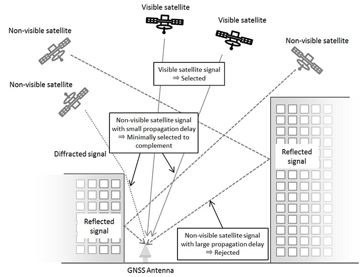
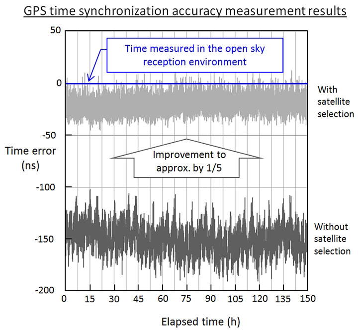
A new receiver for GPS and other GNSS improves time-synchronization accuracy in areas with severe reception conditions, such as among buildings and in mountainous areas.
Furuno plans to begin sales of the new GF-88 series time synchronization GNSS receivers in April 2019, and to deploy it widely in fields such as 4G/5G mobile base stations, financial trading, power grids and data centers.
The GF-88’s new algorithm makes use of multipath signals, those reflected or diffracted from buildings and other structures, which previously inhibited accuracy of time synchronization.
By integrating a new satellite signal selection algorithm developed by NTT into Furuno’s time synchronization GNSS receiver, in addition to signals from satellites in line-of-sight locations, multipath signals can be used to reduce time error, the companies said.
In a real multipath reception test environment, time error was reduced to approximately one fifth of earlier values.
The remarkable result promises to enable time synchronization accuracy close to that obtained in open-sky reception environments with no obstructions, even in environments previously considered poor and unsuitable for accurate time synchronization, such as among buildings or in mountainous areas.
The companies will exhibit the results at Tsukuba Forum 2018 Oct. 25-26, and at ITSF 2018, in Bucharest, Romania, Nov. 5-8.
Fujitsu has introduced a low-power multi-GNSS module for consumer devices and asset tracking. (Graphic: Fujitsu)
The MSB1054 multi-receiver module requires no external components and has built-in Flash memory, meeting needs of smartwatches, fitness trackers, logistics and navigation.
Fujitsu Electronics Europe (FEEU) is expanding its ultra-low power portfolio to include a multi-receiver GNSS module: the MSB1054. The ability to receive signals from several satellite systems significantly reduces the time to first fix, providing for faster and more accurate positioning, the company said.
Photo: Fujitsu
Besides the GNSS device itself, the MSB1054 provides a built-in RF-front end (SAW filter, low-noise amplifier) as well as a temperature compensated crystal oscillator (TCXO), so with the exception of an antenna no external component is required.
Furthermore, Fujitsu’s GNSS module is equipped with a built-in Flash memory for quick “hot start” to save the navigation data and further optimize performance.
With its dimensions of 5.8×6.2×1 millimeters and 3.4 mA current in low-power mode (such as for tracking), the MSB1054 is designed for a variety of applications such as smartwatches, fitness trackers and asset tracking, and can navigate indoors or outdoors, the company added.
The U.S. Federal Communications Commission will vote in November on whether to allow U.S. devices to access Galileo.
The Galileo Order is tentatively on the agenda for the Open Commission Meeting scheduled for Thursday, Nov. 15:
Galileo Order – The Commission will consider an Order that addresses waivers of certain satellite licensing requirements for receive-only earth stations operating with the Galileo Radionavigation-Satellite Service. (IB Docket No. 17-16)
“Enabling the Galileo system to work in concert with the U.S. GPS constellation should make GPS more precise, reliable and resilient for American consumers and businesses alike ,” said FCC Chairman Ajit Pai.
In 2015, the National Telecommunications and Information Administration (NTIA) submitted to the FCC a request from the European Commission to waive certain of the commission’s earth station licensing rules to permit non-federal U.S. receive-only earth stations to operate with Galileo.
The NTIA recommended grant of the requested waivers, and the International Bureau issued a Public Notice seeking comment on the potential public interest benefits and technical issues associated with the waiver request.
The FCC is proposing to waive its licensing requirements for non-federal operations with Galileo signals known as E1 and E5, subject to certain technical constraints, officials said.
The FCC includes conditions to ensure users of satellite-based positioning, navigation and timing services in the United States will benefit from Galileo signals. The systems are interoperable under a 2004 agreement.
Below is a summary of the order; the full text can be downloaded here.
Grant in part the request of the European Commission for waivers of certain of the Commission’s earth station licensing rules to permit non-federal U.S. receive-only earth stations to operate with specific signals of the Galileo GNSS without obtaining a license or grant of market access.
Find that the Galileo GNSS is uniquely situated as a foreign GNSS system with respect to the U.S. GPS, since the two systems are interoperable and radiofrequency compatible pursuant to the 2004 European Union/United States Galileo-GPS Agreement.
Find that there are significant public interest benefits associated with operations of non-federal U.S. receive-only earth stations with the Galileo GNSS, including increased availability, reliability, and resiliency of position, navigation, and timing services in the United States.
Grant the request for operations with the Galileo E1 signal, which is transmitted over the 1559-1591 MHz frequency band.
Grant the request, and a waiver of the non-federal portion of the U.S. Table of Frequency Allocations, for operations with the Galileo E5 signal, which is transmitted over the 1164-1219 MHz frequency band.
Deny the request for operations with the Galileo E6 signal, which is transmitted over the 1260-1300 MHz frequency band, since there is no federal or non-federal allocation for RNSS in the U.S. Table of Frequency Allocations in that band and grant of waiver could constrain our future spectrum management for non-federal operations in the U.S. in spectrum above 1300 MHz, where potential changes in the non-federal allocation are under consideration.
By Paolo Crosta, Paolo Zoccarato, Rafael Lucas and Gerarda De Pasquale, European Space Agency
Test set-up. (Image: Authors)
Most mass-market manufacturers have already developed a dual-frequency chip or will soon do so. What is still not completely clear is the main benefit of adding the second frequency. Is it beneficial just for correcting ionospheric error?
Will it provide an improvement of the ranging error thanks to the wideband nature of the signal broadcast on the second frequency and their multipath rejection capabilities? Is it improving the measurement quality by means of a higher transmitting power?
Could it be exploited as a source of data for the provision of accurate orbit and clock corrections? What is the best PVT algorithm to apply to a multi-constellation dual-frequency mass-market chip?
To answer these questions, an evaluation kit of the Broadcom chip BCM4775 has been tested — the first dual-frequency mass-market chip commercially available.
Results show:
the code noise (multipath) is often the main source of error, hiding the benefits of more accurate clocks and orbital data.
wide-band signals are very beneficial for multipath rejection. Position fix based on E5a-L5-only measurements even with fewer satellites can outperform L1-E1-only in tests performed this September (impact of the new Galileo satellites).
after deactivation of the duty-cycle tracking on Android phones, the carrier phase measurements are improved and we do not experience any longer filter resets in the position Kalman filter.
Skyworks Solutions‘ advanced wireless engines are enabling Philips’ CityTouch end-to-end street lighting management platforms.
Specifically, Skyworks’ connectivity solutions provide efficiency, extended range and complete network coverage to facilitate seamless communication between Philips’ smart street lamps and cellular base stations.
The innovative devices allow city operators to reduce power consumption and support public safety through adaptive scheduling and remote services, the company said. Installations of CityTouch have commenced worldwide, fostering more livable and sustainable environments.
Local governments are increasingly using internet of things (IoT) and artificial intelligence (AI) innovations to overcome fiscal, environmental, security and energy challenges. Skyworks’ robust portfolio of IoT architectures are empowering numerous applications for intelligent city operations spanning smart metering, surveillance systems and responsive traffic signals.
“Skyworks is playing an integral role in the transformation of cities into dynamic, automated ecosystems,” said Carlos Bori, vice president of sales and marketing for Skyworks. “In particular, our high-performance wireless solutions are facilitating highly efficient, long-range connectivity for IoT platforms. Looking ahead, as cities become even smarter with the convergence of diverse AI applications, Skyworks is delivering the enabling technologies that will usher in a new era of connected living.”
According to ABI Research, IoT technology revenues across 12 key smart city verticals are expected to grow from $25 billion in 2017 to $62 billion by 2026. This growth is being driven by a number of factors including the modernization of city infrastructure systems, increasing demand for intelligent, energy-saving street lighting and a growing awareness among consumers and governments worldwide.