Category: Survey

  • Expert Advice: Managing the GPS Constellation for Today’s Needs

    Expert Advice: Managing the GPS Constellation for Today’s Needs

    John Lavrakas
    John Lavrakas

    In a recent editorial in GPS World’s Survey & Construction e-newsletter entitled “No Joy in Surveyville,” Eric Gakstatter lamented the performance of the GPS constellation for surveying. He is not alone. In June, the Australian Broadcasting Company reported that farmers in Australia were experiencing major problems with GPS because two satellites had been removed from service.

    For many, GPS is at its best performance ever, with 29 satellites in orbit and user range errors at their lowest levels in years. Yet for others, GPS performance falls short of expectations. What is the real issue here? Is it the number of usable satellites in the constellation — or have the demands of the user community grown?

    Today’s Performance

    Let’s first take a look at the performance relative to the current constellation. The GPS Standard Positioning Service (SPS) Performance Standard identifies 24 nominal orbital slots for a 24-satellite constellation. In this article, I refer to these as the 24 primary slots. My source material for the slot allocations is the U.S. Coast Guard operational advisories.

    Examining GPS performance over the past three years with respect to satellites in the key orbital slots, we see some interesting trends. Figure 1 presents the average number of satellites on orbit as well as the average number of healthy satellites in the 24 primary slots. A healthy satellite is one that has not been removed from service either due a scheduled outage (satellite and clock maintenance) or from an unscheduled anomaly (for example, degraded clock operation or problems with the spacecraft bus).

    Figure 1. Average number of healthy satellites on orbit (blue) and average number of healthy satellites in the 24 primary slots (red).
    Figure 1. Average number of healthy satellites on orbit (blue) and average number of healthy satellites in the 24 primary slots (red).

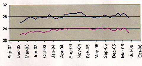
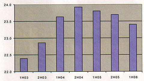
    The number of usable (healthy) satellites grew from 26 to about 28 on average, but this has not changed substantially in the past three years. It has varied between 27 and 29 satellites, with no significant upward or downward trend over this period. The number of satellites in primary slots, however, does show a noticeable trend, growing steadily through 2003 until late 2004 when it leveled off, after which it began to decrease. This trend recurs in Figure 2, where we view the same metric in half-year increments.

    Figure 2. Average number of healthy satellites in primary slots, shown in half-year increments.
    Figure 2. Average number of healthy satellites in primary slots, shown in half-year increments.

    The reduced number of filled primary slots stems from unscheduled outages. Scheduled outages have no significant impact on number of satellites usable since the operators typically remove a satellite from service for only a few hours, and such maintenance is performed on the order of once a month per satellite. Unscheduled outages, however, can last days and may require significant effort on the part of the satellite operators to resolve.

    The SPS Performance Standard states that 24 operational satellites must be available on orbit with 0.95 probability (averaged over any day). We see this figure has been met at the 100 percent level over the past three and a half years.

    The SPS Performance Standard further states that at least 21 satellites in the 24 nominal plane/slot positions must be set healthy and transmitting a navigation signal with 0.98 probability (yearly average). This figure is met.

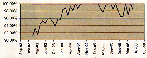
    Figure 3 presents the monthly availability of the primary 24-satellite constellation (blue plot), that is, the percent of time over a month that there is a full set of 24 usable satellites in their primary slots. Here we see a marked trend, showing a steady growth from the beginning of 2003 up to the end of 2004, followed by a reduction, but still above the 95 percent level. Figure 3 also shows the monthly availability of 21 or more satellites assigned to the 24 primary slots (red plot), which has been at 100 percent over the past three and a half years.

    Figure 3. Monthly availability of the primary  24-satellite constellation (bue) and of 21 or more satellites assigned to the 24 primary slots (red).
    Figure 3. Monthly availability of the primary 24-satellite constellation (bue) and of 21 or more satellites assigned to the 24 primary slots (red).

    So What’s the Problem?

    If the U.S. government is meeting its commitments, why do users see degraded performance?

    Part of the issue is that the government manages the constellation to a set of metrics that is not up with the times, so to speak. The SPS Performance Standard has a legacy dating from prior to May 2000 when the government imposed Selective Availability, the intentional degradation of the positioning and timing accuracy for civilian users.

    Surveyors back then were considered eccentrics, as it were, living off the crumbs that fell from the table of the basic service. They took advantage of carrier phase tracking, but were content to post-process the data. Work that took days and weeks prior to GPS could now be done in hours. Well, those days are gone, and the push is now to get work done in minutes.

    The familiar adage “Give GPS users a yard and they’ll want an inch” has a corollary: “Give GPS users a process that takes them hours and they’ll want it done in minutes — or seconds!” Users have found they can do their processing much faster, as long as the constellation performance is well above the levels set in the SPS Performance Standard. This has indeed been the case since 2000.

    The GPS program has placed into orbit more satellites than originally anticipated. The general thought was that 27 satellites were sufficient to support the 24 satellite constellation. With 28, 29, and even 30 satellites in orbit, GPS has exceeded expectations, yet now the new expectations are that the government will sustain this level of performance.

    Improvements Happen

    The U.S. Air Force has made significant improvements in GPS operations as well in recent years. The satellite operators have become more user-focused. Prior to taking a satellite offline for maintenance, operators examine the effect of its removal to users worldwide. Also, they have adjusted operational procedures such that anomalies that once took hours to correct are now resolved within minutes. These improvements have directly benefited users, yet despite this, the mindset of the GPS operators is still to provide the service identified in the SPS Performance Standard, which is not the same as day-to-day service that users have come to expect.

    The Presidential Policy on National Space-Based Position, Navigation and Timing (PNT), issued in December 2004, provides high-level guidance on what service users can expect. Among its goals for space-based PNT, the policy states:

    • provide uninterrupted availability of positioning, navigation, and timing services
    • meet growing national, homeland, economic security, and civil requirements, and scientific and commercial demands.

    What “availability” is assumed in the first goal? Is it availability for users employing the 5-degree mask angle (as defined in the SPS Performance Standard), or is it the more stringent demand of mask angles at 10 degrees or higher? Is it availability of four satellites in view to support the generic user or that of six satellites in view to support receiver autonomous integrity monitoring with fault detection and exclusion?

    What “demands” mentioned in the second goal are to be met? Are they the demands of the precision farmer and surveying community? Or perhaps the tighter requirements of the urban user?

    This policy also states that the government will improve the performance of space-based positioning, navigation, and timing services. This implies that the service identified in the SPS Performance Standard will need to be changed to accommodate these improvements.

    To some extent, the U.S. government can only go so far in meeting user needs with the current system. The maximum number of satellites today’s operational control system can support is 30. As of the time of this article, GPS had 29 operational satellites on orbit, although at any given time not all are usable, due to necessary maintenance or unscheduled downtime. Whenever satellites are set unusable, the satellite operators look at the resulting performance, comparing it to the SPS Performance Standard. This is where the issue lies. The SPS Performance Standard assumes a generic user with only a 5-degree mask angle, yet this one assumption no longer represents a significant class of GPS users: the precision users.

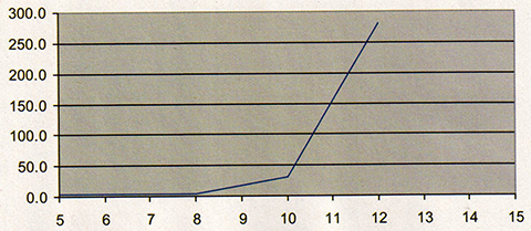
    If there are 29 satellites available, why is a reduction to 27 such a big issue? Today’s GNSS users are more demanding than the users were even five years ago. Accuracy is the thing, and real-time accuracy is the most important thing. Today GNSS is used in precision applications such as agriculture, surface mining, and seismic drilling. To get the needed accuracy, users of GNSS exclude low-elevation angle satellites to mitigate the effects of the atmosphere. They set the mask angle in their receivers to 8, 10, even 12 degrees. This higher mask angle reduces the number of available satellites to the users, and correspondingly the dilution of precision and associated positioning error goes up, as illustrated in Figure 4.

    Figure 4. Picture of DOP performance over various mask angles for June 5, 2006.
    Figure 4. Picture of DOP performance over various mask angles for June 5, 2006.

    Is GPS Properly Managed?

    So the issue becomes, is the U.S. Air Force managing the constellation in the best interests of all of its users? Is keeping older satellites in orbit the best policy, and asking the satellite operators to do the best they can with the constellation provided to them? Or is it better to expend taxpayer dollars to replace the older, yet still operational, satellites with newer satellites?

    From a user’s perspective, the newer satellites are better — far better than the older satellites in range accuracy, health, and resistance to integrity failures. The increased reliability produced by their redundant systems also acts as insurance against longterm failures of GPS.

    Today’s users do expect more from GNSS. While today they have but one choice, in the future they will have at least two others, as Galileo and GLONASS come online. So it is important for the U.S. government to continue to adapt GPS operations to support its current user base.

    Recommendations

    There is no easy solution to the problem of ensuring that GPS continues to meet today’s user’s needs, since the field of users and applications is becoming more diverse and demanding. For many, the preferred answer is to launch more satellites, keeping the level at 30 satellites, but there are significant cost implications with this approach.

    On the other hand, relying on an aging constellation to remain operational is also fraught with peril. Many satellites are on their final legs, with key components on a single point of failure. The clocks onboard the satellites are not as stable as they used to be, and require considerable attention from the satellite operators. The cost of losing satellites is significant for certain sectors in our economy, the sectors that employ precision GNSS. In the distant future this problem will be eliminated through the diversity of fully operational Galileo and GLONASS constellations, but for now the issues are immediate and real.

    The U.S. government can and should take several steps to better address the increasing demands on GPS:

    • The government should update the SPS Performance Standard to accommodate other classes of users and bring the metrics up to date with respect to current performance.
    • The satellite operators should refine their assessments of user impact to include a view of how special classes of users are impacted. In particular this should include precision users and aviation applications. This involves using higher mask angles in their assessments and incorporating receiver autonomous integrity monitoring (RAIM) availability.
    • The decision-making authorities in GPS should continue to support an aggressive program to replace aging satellites.

    Such improvements will continue to benefit GPS users worldwide, and help ensure the U.S. government’s goal of providing the best PNT service available.


    John W. Lavrakas is a consultant in satellite navigation. He has spent the past 26 years in GPS, working in satellite command and control, user operations, GPS receiver development, and satellite navigation performance analysis. Contact him at [email protected].

  • NDGPS Heads Toward the Budget Chop Block

    Nationwide Differential GPS (NDGPS) heads toward the budget chop block. Its 2007 allocation has been scaled back to zero.  As in aught, nought, zot.

    NDGPS, also referred to as the Coast Guard differential system, made its first NDGPS broadcast in the early-to-mid-90s. After years of industry talk about real-time DGPS, NDGPS was the first, mostly reliable source of real-time corrections that was free of charge (via your tax dollars).

    Support from the mapping and non-aviation navigation markets pushed the government (the Department of Transportation took the lead) to continue the build-out of the NDGPS network. Each year, more sites were added, and NDGPS became a solid resource for folks wanting a free source of DGPS corrections that delivered meter-level accuracy. They just had to buy the hardware (beacon receiver and antenna) to use it. Today, more than ten years later, there are more than 80 broadcasting sites — and more planned — spread out over the continental United States, Alaska, and Hawaii, providing free DGPS coverage used by hundreds if not thousands of users on a daily basis.

    A successful program?

    Up to and including FY 2006, Congress and the President allocated a substantial annual budget for NDGPS improvements, operations, and maintenance. For example, the FY 2006 budget came to approximately $10 million — half of what was originally requested. Almost $100 million more is needed to complete the network build-out. After that, about $9.2 million is needed annually to operate and maintain the system.

    However, unlike years past, this years budget (FY2007) for NDGPS improvements, operations and maintenance is………………….$0 (zero). The rumor mill says that since there’s no money to operate and maintain, some sites may actually be shut down. That’s not the case according to the Department of Transportation, however.

    “The FY06 budget provides approximately $10 million for the NDGPS program.  These funds will be used to operate and maintain the existing NDGPS system through October 1, 2007”, says Steven Kulm, Director, Office of Pubic Affairs for the DOT’s Federal Railroad Administration.

    So that means no money for new sites that were planned for FY 20007, and no money for developing new technologies such as High Accuracy (HA)-NDGPS.

    Wow, what went wrong?

    The problem facing NDGPS today, in my opinion, is the lack of a “killer app.” In other words it’s a neat tool and serves hundreds (if not thousands) of people on a daily basis, but if it disappeared tomorrow, life would go on. Therefore, when it comes to cutting the budget during tight times, programs like NDGPS are prime targets.

    Now, I’m guessing the DOT may say that PTC (Positive Train Control) may be the killer app for NDGPS because it reportedly will save the railroad industry “billions” each year. That may be so, but if it was that easy to sell, then no one would be hacking away at the relatively puny NDGPS budget.

    Putting the pressure on NDGPS is the Federal Aviation Administration’s (FAA) Wide Area Augmentation Service (WAAS) program. Like NDGPS, WAAS is a free government service providing corrections to improve accuracy and reliability of GPS positioning. The FAA began developing WAAS in the mid-90s and it was declared operational in July 2003.

    WAAS has two things going for it that NDGPS doesn’t.

    • A killer app. The future of aviation navigation is based squarely on GPS, and WAAS is an integral part of that program. The FAA is banking so heavily on GPS and has so many initiatives based on GPS, that there is no way it can back its way out of the program…and it shouldn’t. There are so many valuable uses for GPS in aviation that it boggles the mind. Some applications are focused on efficiency (e.g. better traffic control and throughput) and others are safety-of-life driven (e.g. situational awareness such as ADS-B). Because of this, the FY 2007 budget for WAAS is close to $100 million.

    • WAAS is easy to use for non-aviation folks like us. It’s a no-brainer and it comes standard on every GPS receiver you purchase today. Whereas NDGPS requires the use of additional hardware (a 300khz receiver) and a separate antenna, no additional hardware or software is required to use WAAS. Using WAAS is virtually automatic. NDGPS receivers will never reach that level of simplicity. Good quality NDGPS antennas, by their nature, are bulky and I have serious doubts that any company will attempt to design an NDGPS receiver-on-a-chip (some have tried and failed), especially at this late stage of the game. With those two strikes, consumer GPS units will never incorporate NDGPS technology. And thus NDGPS will never achieve mass-market status like WAAS already has.

    Availability

    The foothold that NDGPS-supporters are hanging onto is the issue of the correction availability. Whereas WAAS is satellite-based and is dependent on line-of-sight between the user and the broadcast satellite, NDGPS broadcasts corrections on the 283-325khz band and does not require line-of-site between the user and the transmitter. It can even be received inside some buildings. However, signal propagation is interrupted by rough terrain and in metro areas, and ambient radio interference can interrupt the signal too. Although it’s not a true national service, there are certainly areas where the NDGPS can be received and WAAS can’t. The reverse can be stated also.

    Accuracy

    The NDGPS vs. WAAS debate in the surveying/mapping community has been a lively one this past year. This is due largely to major GPS manufacturers introducing professional mapping GPS receivers that use WAAS to achieve meter-level accuracy. Although NDGPS has the capability of being more accurate than WAAS, meter-level accuracy seems to be good enough for most mapping applications given the additional expense and equipment overhead required to use NDGPS. Think about it: Garmin discontinued their NDGPS receiver product line and now every GPS product they sell is WAAS-enabled.

    Fate

    Clearly, from a funding perspective WAAS has won the battle for now and has NDGPS back on its heels. The next twelve months (or less) will determine the direction of the NDGPS program.

    “At this time, the U.S. Department of Transportation is deliberating how to administer the program in the future.  We anticipate the Administration’s proposed FY08 budget (to be released in early 2007) will provide guidance on what the future of NDGPS will be,” says Kulm.

    The challenge for NDGPS-supporters in the next few months is to not let the purse-string holders forget about NDGPS and its niche applications. If it’s business-as-usual in FY 2007 and the purse-string holders don’t feel the pain, what are the odds they’ll throw money at NDGPS in FY 2008?

    — Eric Gakstatter

  • No Joy in Surveyville

    I have something to say about our mainstay — GPS — and its troubles of late. So many people in the survey/mapping community have asked me when this problem is going to be resolved. The problem is there aren’t enough healthy satellites for surveying community to use.

    I think the GPS decision makers don’t believe there is a problem because
    with a clear sky, you still get a 3D position, anytime, anywhere in the world.
    Herein lies the problem: we don’t usually work in clear-sky environments.
    Neither do consumer GPS users. My Honda Odyssey GPS navigation system doesn’t
    get a GPS position fix nearly as much as it used to.

    (Just to clarify: I’ve spent the past 16 years in the GPS survey/mapping
    industry using many brands of GPS equipment and software. My first ten years
    in GPS were spent as a product manager and the last six years as a GPS user
    and consultant. I’m a non-partisan advocate for the GPS user community.)

    The fact is that GPS has suffered more outages to key satellites (or satellites
    in key orbital slots) in the past year than it has since GPS was declared operational
    in the early 90’s.

    PRN 25 has behaved like a legacy Jaguar automobile for the past 6+ months:
    an hour shut down for maintenance for every hour it has spent operational.
    Of course I’m exaggerating, kind of, but I’m sure you understand
    my point if you’ve been using RTK with any frequency for the past 6+
    months. I reported last month that the next GPS satellite launch (scheduled
    for September ’06) would most likely replace PRN 25 according to the
    Chief GPS Liaison at the USCG, Doug Louden. But I’m beginning to doubt
    this, given the precarious slot that PRN 30 occupies and its surprisingly rapid
    decline in health. PRN 30 is on its last clock from what I understand. It isn’t
    as old (9.5 yrs) as PRN 25 (14 yrs), but it’s still two years past its
    design life.

    Other GPS satellites are significantly past their design life and heading
    for failure. You can’t use RTK a full day with the current GPS constellation
    even with every satellite healthy. Take one out that’s in a key slot
    like PRN 25 or PRN 30 and it gets really ugly.

    I think it’s not unreasonable to ask the GPS JPO for a healthy, reliable
    constellation of GPS satellites.

    Delays in launching replacement satellites have been so significant that GPS
    users have quit asking me about new launches. It looks like only one will be
    launched in 2006 and only one will be launched in 2007 — if the schedule
    doesn’t slip further. This is a far cry from the “three-a-year” launch
    plan laid out a few years ago.

    I don’t believe the GPS JPO thinks there is a problem, but you only
    have to look at the new product introductions to understand that there is.  For
    years, most survey-grade GPS manufacturers ignored GLONASS and thought it would
    go away, and GPS would fill the bill. However, in the last 12 months, the number
    of survey-grade GPS manufacturers offering GPS/GLONASS products has at least
    doubled.

    Meanwhile, GLONASS is pushing forward with an aggressive launch schedule.
    Three in December ‘06, three in Q3 ’07 and three in Q4 ’07.
    Furthermore, the two new GLONASS satellites that are already in orbit are reportedly
    to be declared operational in the next 60 days. Granted, only time will tell
    if they can honor that schedule, but even launching half of what they plan
    would be significant.

    So, I’d like to raise my hand from the back of the classroom and say
    the Survey, Construction and GIS industry segments aren’t happy with
    the way GPS is performing these days.

    — Eric Gakstatter

  • Potential Problems for Users of Modernized GPS Signals in Mixed-Mode Operations

    PRN 17, the first IIR-M satellite launched in September 2005, began broadcasting the second GPS civil signal, L2C, in December 2005. PRN 17 is the first in the new generation of GPS satellites with a new feature called flex power. According to the U.S. Air Force, flex power adds the capability for the Department of Defense to increase power on both P- and M-code (both military) signals to defeat low-level enemy jamming.

    When flex power was enabled for testing (for a very short period of time), a problem was observed by certain GPS users. This problem was associated with the definition of the phase relationship between L2C and legacy L2 P/Y. In this scenario, users who are operating L1/L2/L2C GPS equipment, in conjunction with legacy L1/L2 GPS equipment, could have a problem maintaining carrier-phase ambiguity resolution with any modernized satellite operating in modes where signal phase relationships are changing or are unknown.

    This is not just a flex power issue, but a potential issue with any new modernized GPS signal if provisions are not included to inform users in real time of signal phase relationships. This is potentially a long-term problem because there will be a mixed set of modernized/legacy signals for an extended period of time, as well as a mixed set of modernized/legacy user equipment. The important thing is that these potential problems can be fixed by broadcasting appropriate data in the GPS navigation messages in a timely manner.

    This fix to this potential problem would slightly change the GPS user interface specifications and add bits for defining the phase relationship between the modernized and legacy signals. This data would have to be added to both the L1 and L2C signals since, for the time being, there is no data on the L2C signals. For L1C, (in the draft L1C specification) the phase relationship between L1C and L1 C/A has been defined. For L2 and L2C interoperability during modernization, a similar parameter to provide the phase relationship between the L2 P/Y and L2C is needed for mixed equipment processing. (Refer to Section 3.5.4.6 subframe 3, page 7 signal phase of the newly released Draft IS-GPS-800 L1C specification dated April 19, 2006.)

    Another possible solution is for L2C-capable receivers in a network to track both L2C and L2 P/Y simultaneously, to directly measure the phase difference between the two phases. However, the drawback is that the more robust L2C signal will be tracked at times when the legacy L2 P/Y cannot &#151 the main reason for implementing L2C in the first place.

    — Eric Gakstatter
    Contributing editor of the Survey & Construction newsletter

  • Potential Problems for Users of Modernized GPS Signals inMixed-Mode Operations

    When the new flex power feature aboard PRN 17, the first IIR-M GPS satellite,
    was enabled for testing (for a very short period of time), a problem was observed
    by certain GPS users.

    PRN 17, the first IIR-M satellite launched in September 2005, began broadcasting
    the second GPS civil signal, L2C, in December 2005. PRN 17 is the first in
    the new generation of GPS satellites with a new feature called flex power.
    According to the U.S. Air Force, flex power adds the capability for the Department
    of Defense to increase power on both P- and M-code (both military) signals
    to defeat low-level enemy jamming.

    When flex power was enabled for testing (for a very short period of time),
    a problem was observed by certain GPS users. This problem was associated with
    the definition of the phase relationship between L2C and legacy L2 P/Y. In
    this scenario, users who are operating L1/L2/L2C GPS equipment, in conjunction
    with legacy L1/L2 GPS equipment, could have a problem maintaining carrier-phase
    ambiguity resolution with any modernized satellite operating in modes where
    signal phase relationships are changing or are unknown.

    This is not just a flex power issue, but a potential issue with any new modernized
    GPS signal if provisions are not included to inform users in real time of signal
    phase relationships. This is potentially a long-term problem because there
    will be a mixed set of modernized/legacy signals for an extended period of
    time, as well as a mixed set of modernized/legacy user equipment. The important
    thing is that these potential problems can be fixed by broadcasting appropriate
    data in the GPS navigation messages in a timely manner.

    This fix to this potential problem would slightly change the GPS user interface
    specifications and add bits for defining the phase relationship between the
    modernized and legacy signals. This data would have to be added to both the
    L1 and L2C signals since, for the time being, there is no data on the L2C signals.
    For L1C, (in the draft L1C specification) the phase relationship between L1C
    and L1 C/A has been defined. For L2 and L2C interoperability during modernization,
    a similar parameter to provide the phase relationship between the L2 P/Y and
    L2C is needed for mixed equipment processing. (Refer to Section 3.5.4.6 subframe
    3, page 7 signal phase of the newly released Draft IS-GPS-800 L1C specification
    dated April 19, 2006.)

    Another possible solution is for L2C-capable receivers in a network to track
    both L2C and L2 P/Y simultaneously, to directly measure the phase difference
    between the two phases. However, the drawback is that the more robust L2C signal
    will be tracked at times when the legacy L2 P/Y cannot — the main reason
    for implementing L2C in the first place.

  • L2C — not just vanilla GPS anymore

    Welcome to the second edition of GPS World’s Survey & Construction e-newsletter. My name is Eric Gakstatter ([email protected]). I’ve spent the past 16 years in the GPS survey/mapping industry using many brands of GPS equipment and software. My first ten years in GPS were spent as a product manager and the last six years as a GPS user and consultant. I’m a non-partisan advocate for the GPS user community.

    This subject of this month’s column is L2C. It’s not just about vanilla GPS anymore. GPS modernization weighs heavily in future of satellite surveying. What does L2C bring to the table? When do the new features become useful enough to start making equipment purchasing decisions? While some of the answers may be obvious, others may surprise you.

    First of all, I’ll preface this column by noting that L2C is only a small part of the Global Navigation Satellite System picture that includes L5, GPSIII,  Glonass (Russia’s satellite system) and Galileo (Europe’s satellite system). Discussing all of the GNSS components is too much for one column so I’ll be chipping away at all of them in the coming months.

    Last September (’05) was a big step for GPS modernization when the first IIR-M satellite was launched…starting the next phase of GPS with a second civilian signal (L2C). Currently, there is one civilian signal (L1 C/A). L2 was designed for military use…although civilian manufacturers have been very resourceful in developing codeless techniques for utilizing L2; therefore making dual frequency receivers (L1/L2) very useful for the user community.

    Basically, L2C can be viewed as an add-on feature to the existing L2 band. In practical terms, L2C will help in two areas:

    • It will allow for user receivers to more accurately correct for the error that is generated when the GPS signal passes through the Earth’s ionosphere. L2C provides manufacturers with a new code, enabling them to address the ionospheric delay in a more direct manner than the codeless techniques used by today’s dual frequency receivers. It will also open the door for non survey-grade GPS manufacturers to design survey-grade dual frequency receivers at a much lower R&D cost with fewer patent blocks.
    • Contrary to popular belief, the L2C signal is weaker (not stronger) than L1 C/A code. The idea that L2C will “punch through the trees” with a stronger signal is incorrect. What L2C does offer is a more robust code structure with improved error-correcting methods that will allow it to be used more effectively in marginal satellite signal conditions than what we experience today. Just how much it will help will only be known when the satellite constellation is in place and the receivers are developed to optimize it.

    These two enhancements will result in more competition in the survey-grade GPS receiver marketplace because survey-grade dual frequency receivers will be easier to design. With increased competition, it’s reasonable to expect more competitive prices. With L2C, you can also expect GPS to perform better in weaker satellite conditions.

    With the benefits of L2C to the survey/mapping market clearly established, when are we going to be able to use it? Well, it’s going to be awhile. The publicized year of 2010 is not realistic as this point. Educated speculation says that 2012 is more likely. Don’t forget that it’s not just a matter of tossing satellites into orbit. There are control and management systems on the ground that need to be developed, tested and rolled-out to make use of the new signal. After the hype generated last September when the first IIR-M satellite was launched, the delays in the follow-up IIR-M launches have been disappointing. For example, the launch scheduled for 1Q 2006 has been pushed out until September…a full year after the first IIR-M.

    From the launch schedule, you can see it’s a bit early to start making equipment purchasing decisions based on L2C. Yes, I think that manufacturers will do their best to exploit a partial constellation of L2C satellites and perhaps there will be some innovative
    developments in that area, but just note that by the time there is a minimum constellation of L2C satellites in orbit, there will be another two or three generations of receivers that will have been introduced to the market.

    I’m at the American Congress on Surveying and Mapping annual conference this week in Orlando. Look for my report on conference news in next month’s issue.

  • WAAS Clarification


    The FAA’s announcement (reported in March GPS World) that WAAS in the northeastern United States and eastern Canada may be significantly inhibited by relocation of WAAS-broadcasting satellite AOR-W before the new PanAmSat becomes fully operational in fall 2006 caused unease in some surveying organizations. Based on tests completed last year, before anyone knew that AOR-W would relocate to 142W longitude, these organizations replaced legacy GPS mapping units using post-processing and the Coast Guard NDGPS with high-performance WAAS-enabled mapping receivers.

    The FAA notice doesn’t tell the full story, however. Two new WAAS broadcasting satellites launched last fall. PanAmSat (133W) began broadcasting in test mode with corrections full-time this March, and Telesat (107W) is scheduled to begin the same mode on or around April 1, 2006. The FAA announcement does not take into account either of these broadcasting satellites.

    If these test signals are considered, there will be no degradation in WAAS visibility. In fact, users in the northeastern United States and eastern Canada will enjoy dual WAAS satellite coverage. WAAS satellite visibility in central and western North America has improved in the past 60 days with the new test signals and relocation of AOR-W.

    However, the FAA won’t certify the accuracy/reliability of the new satellites until after extensive testing. Until then, non-aviation receivers may use the signals at their discretion &#151the same mode WAAS operated in prior to its July 2003 commissioning. Also, non-aviation WAAS receivers may not be configured to use the new test signals; check with the manufacturer.

    &#151 Eric Gakstatter, Editor of GPS World’s new Survey &#38 Construction E-Newsletter

  • Welcome to GPS World’s Survey & Construction Newsletter

    Hello, and welcome to the first issue of GPS World’s Survey & Construction Newsletter. You are encouraged to forward this email to your colleagues, and they in turn are encouraged to sign up for their own — free — subscription.

    I’m Eric Gakstatter ([email protected]), your editor on this resource for the survey and construction communities. I’ve spent the past 16 years in the GPS survey/mapping industry using many brands of GPS equipment and software. My first ten years in GPS were spent as a product manager and the last six years as a GPS user and consultant. I’m a non-partisan advocate for the GPS user community.

    The first subject I’ve selected to discuss with you is the FAA’s WAAS program because of the recent and significant changes that have taken place in this program.

    WAAS UP?

    WAAS is one of the most widely misunderstood GPS technologies of today in the survey/mapping marketplace. Recent WAAS broadcasting satellite launches and a WAAS broadcasting satellite relocation along with vague press releases have further muddied the waters. In the interest of panic-relief for survey/mapping WAAS users, a more prudent, in-depth explanation is warranted.

    Recently, I was on a construction site for a project I’m involved with. It was a park-like setting with a lot of drainage and irrigation being laid. From the beginning, I knew the job superintendent was very comfortable with technology. The younger, lean fellow spoke efficiently, carried a laptop and seemed on top of his game when questioned by various owner’s reps and sub-contractors….he even carried a hand-held GPS mapping receiver that he used to map various structures installed throughout the project.

    Of course, I had to talk with him about his thoughts and perceptions of GPS. A part of the conversation went as follows:

    Me: How accurate has that unit been for you?

    Him: Very accurate. Do you see that little airplane on the screen (he points at the screen)?

    Me (looking at his screen and trying to figure out what he’s talking about): Oh, yes.

    Him: That means there’s an AWACS airplane flying near here sending me corrections. You know, the military airplane with the big antenna on it?

    I sighed deeply as the image my mind had built of this young, high-tech construction superintendent faded away.

    That “little airplane” on the screen he was referring to was an indicator that his GPS receiver was using corrections from a Federal Aviation Administration (FAA) Wide Area Augmentation System (WAAS) satellite.

    WAAS is perhaps one of the most widely misunderstood GPS technologies of today in the survey/mapping marketplace and the above conversation is a typical example.

    Further complicating this is the recent announcement by the FAA that WAAS in the northeastern US and Eastern Canada may be significantly affected by the relocation of AOR-W (the US east coast WAAS broadcasting satellite) before the new PanAmSat will be considered fully operational in Fall 2006. See the FAA announcement at http://gps.faa.gov/programs/waas/non-aviationUsers.htm.

    The FAA announcement set off a panic in some organizations that had recently implemented a significant number of high performance, WAAS-enabled mapping receivers to replace legacy GPS mapping units that used post-processing and the Coast Guard NDGPS system. These organizations based their decisions on performance tests completed last year before anyone knew that AOR-W was going to relocate to 142W longitude instead of 98W longitude as originally announced.

    The rest of the story…

    First of all, two new WAAS broadcasting satellites were launched last Fall. One of them (PanAmSat at 133W longitude) began broadcasting in test mode with corrections full-time this month (March). It is expected that the other (Telesat at 107W longitude) is scheduled to begin broadcasting test mode with corrections full-time on or around April 1, 2006. The FAA announcement does not take into account either of these broadcasting satellites.

    If these test signals are considered, there will be no degradation in WAAS visibility. In fact, users in the Northeastern US and Eastern Canada will enjoy dual WAAS satellite coverage. For example, in Montreal, Quebec the two new WAAS broadcasting satellites will be visible at ~28 degrees and ~12 degrees above the horizon. Before the AOR-W relocation, it was the only WAAS satellite visible and it was at ~36 degrees above the horizon.

    WAAS satellite visibility in the central and western US, Mexico and western Canada has improved dramatically in the past 60 days with the new test signals and relocation of AOR-W. For example, in Portland, Oregon, WAAS satellite POR is visible at ~12 degrees above the horizon. The two new WAAS broadcasting satellites and relocation of AOR-W to 142 degrees west longitude now means that three additional WAAS satellites will be visible at ~32 degrees, ~36 degrees, and ~35 degrees above the horizon in the Pacific Northwest.

    The caveat is that the FAA won’t certify the accuracy/reliability of the new WAAS broadcasting satellites for quite some time after extensive testing. Until that time, non-aviation receivers are free to use the test mode signals at their discretion. This is the same mode that WAAS was operating in prior to it’s July 2003 commissioning. Also, your non-aviation WAAS receiver may or may not be configured to use the new test signals. You should check with the manufacturer of your unit.

    Well, I didn’t have the heart to tell him then there weren’t any AWACS airplanes sending him corrections (although I did tell him later). It’s just one more example I’ve encountered of the misinformation floating around about WAAS among survey/mapping professionals. There is not enough space in this issue to debate the advantages/disadvantages of WAAS for survey/mapping usage, but don’t be so quick to dismiss the technology before you fully investigate it’s performance and consider the recent developments.