Category: Transportation

  • Clarion Selects Averna for Testing In-Vehicle Infotainment Systems

    Averna’s Record & Playback platform.
    Averna’s Record & Playback platform. Photo: Averna

    Averna, a developer of test solutions and services for communications and electronics device makers, announced today that Clarion has selected Averna’s Record & Playback solution to validate upcoming in-vehicle entertainment systems and certify that the devices perform well in real-world conditions. Clarion is a global manufacturer and seller of car navigation systems and in-vehicle equipment with a focus on car audio systems.

    The R&D Division, Experiment and Evaluation Team at Clarion will use Averna’s R&P platform to record radio signals such as AM, FM, HD Radio, and DAB from key locations around the world and replay them in the Tokyo-based lab where the design team is located.

    The R&P platform selected by Clarion features:

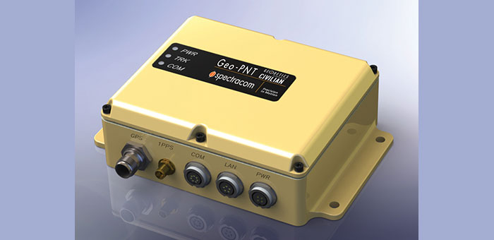
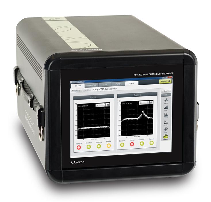
    • RP-5100, a compact 2-channel RF recorder designed to record live RF signals in the field
    • URT-5000, a software-defined RF Player and Signal Generator
    • RF Studio, high-performance RF record-and-playback software for RF product designers and researchers to facilitate recording, analysis and storage of RF signals
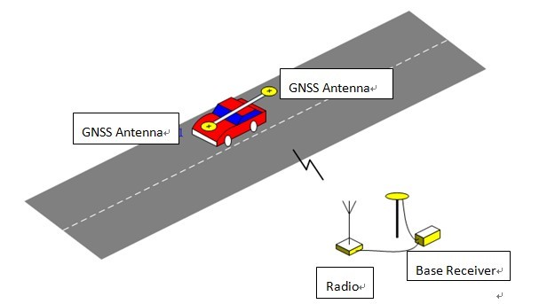
    • DriveView plug-in for synchronized recording/viewing of video, audio, and GPS positioning data

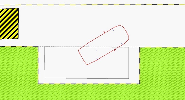
    The Averna RP-5100 RF Recorder is specifically designed to capture real-world RF signals, with impairments, for navigation as well as broadcast radio and video receiver validation, testing and support. The system has two 20-MHz wide channels that can be tuned on any frequencies from 250 kHz to 2.65 GHz. To address the challenges of validating the RF response with the physical environment, Averna has developed DriveView, a plug-in for the proprietary RF Studio software, offering visual verification by video-recording drive tests.

    “Clarion needed a platform to record live RF environments and reproduce them in a repeatable manner in their lab. Our R&P solution allows them to go through all the different use cases without having to go back in the field at each testing phase,” said Etienne Frenette, VP of Sales, Asia for Averna. “As receivers become more complex, it is imperative that real-world signals and conditions be recreated for thorough validation and testing in order to help enhance the user experience.”

    “We recognize and appreciate Averna’s unique expertise and advanced solutions in device performance testing,” commented the R&D Division, Experiment and Evaluation Team at Clarion. “Clarion is dedicated to delivering better products reaching the market faster and Averna is helping us achieve this goal.”

  • Spectracom Teams with Geodetics For Rugged PNT Equipment

    Spectracom Teams with Geodetics For Rugged PNT Equipment

    Spectracom announced today a strategic partnership with Geodetics Incorporated of San Diego, California. The partnership includes a variety of initiatives to enhance each company’s customer reach, channels, products and technology.

    The partnership includes a distribution agreement for Geodetics’ Geo-iNAV inertial navigation products. Spectracom will offer Geo-iNAV alongside its portfolio of precision timing, test and simulation equipment. Geo-iNAV is a fully integrated GPS-aided inertial navigation system that provides real-time, high-precision positioning and navigation solutions for manned and unmanned air, sea and ground vehicles. It combines GPS and sensor fusion to achieve centimeter-level real-time positioning and navigation for dynamic platforms.

    “In line with our long heritage in delivering robust precision time and frequency products and services, we understand the challenges our customers face to adopt and adapt new and often disparate GPS and GNSS technologies,” said Spectracom President and CEO, Lisa Withers. “We believe our partnership with Geodetics will help to simplify the integration of complex positioning, navigation and timing technologies and provide our customers with a broad range of GPS and inertial navigation platforms readily suited for today’s dynamic and mobile environments.”

    Geodetics President and CEO Lydia Bock added, “Spectracom’s global reach immediately widens the playing field for our inertial navigation products and technology. They have a keen sense of customer’s needs for the convergence of PNT in both military and commercial applications.”

    As the GNSS eco-system expands to support mission critical applications, so must the prevalence of interoperability and signal fidelity, and ultimately PNT applications must be able to withstand the temporary loss of GPS due to factors such as signal obscuration, Spectracom said. As such, contemporary GNSS signal management solutions must be resilient to various GPS impairments as required of the application. Geo-iNAV delivers this capability through six configurations. It is available in commercial as well as SAASM GPS configurations as well as a choice of IMU depending on accuracy requirements. It offers a low SWaP (size, weight and power) profile for autonomous vehicles and payloads on manned vehicles to meet a wide range of applications.

    As a part of Spectracom’s broader initiative to provide a comprehensive portfolio of GNSS signal management products, systems and services, the Geo-iNAV is the first in a series of compact and rugged solutions specific to PNT applications. In addition to simplifying complexity for its customers with contemporary, modular platforms, Spectracom’s market reach, together with the technical strengths of their partners such as Geodetics will accelerate time to market and aggregate the resources necessary to support unique and changing needs for precision references, simulation and signal test and analysis.

  • ComNav GNSS OEM Boards Used in China Driving Test System

    Along with booming auto sales in China has come an increase in auto accidents, which has been a headache for the Chinese government. According to police statistics, most of the accidents in the past couple of years were being caused by new  drivers, who have been ignominiously dubbed “road killers.”

    One year ago, the China Police Ministry decided to change the method of licensing new drivers by using stricter methods for training and testing. The new system also was designed to avoid cheating.

    Under to the new testing system rules, the high-accuracy GNSS receiver became the ideal sensor to enforce the new testing, according to ComNav, a ShangHai-based OEM receiver maker. By offering a turnkey solution, from November 2012 to July 2013 ComNav sold more than 5,000 GNSS OEM boards/receivers for driver testing — the major share of that market.

    The system uses the real-time kinematic (RTK) method to establish the accurate heading and position of the car, with a ComNav M600 GNSS receiver. A base station sends differential data to a rover installed on the car. With the help of 3G or Wi-Fi, the real-time data is transmitted to the control center. Examiners can then can judge whether the car is in the right area. Both the trainee and system will know the testing results without delay.

    Surveying the testing place, marking the testing area, and measuring the car shape need to be done before the installation.

    ComNav Technology Ltd. is a high-accuracy positioning solutions supplier that focuses on high-accuracy GNSS core technology R&D, manufacturing and marketing. ComNav is the first Chinese high-accuracy GNSS OEM board manufacturer and producer of a GPS+BeiDou OEM board.

    System diagram.
    System diagram. Source ComNav
    Side parking test.
    Side parking test. Source ComNav


  • Geotab Launches Telematics ID Key Solution with IOX Technology

    Geotab Launches Telematics ID Key Solution with IOX Technology

    Geotab has launched a telematics Near Field Communications (NFC) Driver ID solution using an Input-Output-Expander (IOX) that allows for simultaneous connections and communications to occur with multiple devices, such as Garmin, Iridium, and HOS.

    As an addition to its comprehensive fleet management platform, the technology will now help managers keep better track of each driver’s productivity and on-road safety — no matter which vehicle they are in, Geotab said.

    With one touch of the NFC fob, vehicle operators can quickly, easily, and securely transfer their driver identification information to the cloud. Since Geotab’s GO6 device allows for multiple plug-and-play connections, the NFC Driver ID solution can be setup in minutes, the company said. Associating drivers with the vehicles they are in also allows for the software to generate driver-based score reports.

    “The newly launched NFC Driver ID is a telematics industry game-changer that provides a reliable and accurate solution for businesses which pool their vehicles,” said Colin Sutherland, Geotab VP.

    “NFC is seeing rapid application expansion across smartphones, tablets, and laptops. We fully expect to leverage this technology for future applications,” added Neil Cawse, Geotab CEO.

    Although Geotab is launching a new Driver ID solution based on NFC, Geotab’s web-based software, MyGeotab, has been reporting both driver and vehicle summary value reports for over 10 years. The NFC Driver ID solution is now available for purchase through Geotab’s extensive Authorized Reseller network.

  • Rugged Tablet for Mobile Professionals

    Rugged Tablet for Mobile Professionals

    T7Q-1(B)
    Photo: GammaTech

    The DuraBook T7Q by GammaTech is a fully rugged Windows 7 Professional tablet PC designed to meet the demands of mobile professionals in the transportation, field services, utilities, and oil and gas industries. Designed with a magnesium-alloy case, the T7Q DuraBook Rugged Tablet is compliant with MIL-STD 810G and IP65, able to withstand vigorous bumps, knocks and sudden shock under rough handling or on-the-move, resisting dust and water.

    It has a seven-inch thin-film-transistor (TFT) LCD display with resistive touchscreen panel and LED backlighting, an m-SATA SSD drive and Intel Atom Processor, and an integrated 5.0-megapixel camera at the back of the unit. Options include a barcode scanner, RFID reader, GPS receiver, and I/O ports such as USB, RS-232, and RJ-45.

  • ALK Releases PC*MILER 27 with Redesigned User Interface

    ALK Releases PC*MILER 27 with Redesigned User Interface

    New York Map in Smooth Map Style

    ALK Technologies today released the latest version of its PC*MILER truck routing, mileage and mapping software. PC*MILER 27 features and enhancements include a completely redesigned graphical user interface for maximum efficiency and hours-of-service compliance tools for more precise arrival and delivery time estimates.

    “PC*MILER 27 is a milestone for ALK. We’re thrilled to unveil this robust yet easy to use interface with an all new look and feel,” said Mike Bodden, Senior Vice President of Technology, ALK Technologies. “The new UI provides an improved user experience with easier product navigation, resulting in increased productivity.”

    The new PC*MILER 27 graphical user interface reflects recent trends in software design that result in more intuitive navigation of the product’s vast feature set. The user interface features a ribbon-style design with newly crafted descriptive icons, a more accessible layout for smoother transition between tasks, and windows that can be floated outside the PC*MILER application to better accommodate workspace needs.

    PC*MILER 27 features new hours-of-service compliance tools to help ensure that routes and ETAs will accurately reflect drivers’ available hours. The HOS compliance tools increase the precision of arrival and delivery time estimates and help dispatchers and drivers comply with HOS government regulations. Based on remaining hours, PC*MILER calculates when a driver needs to break, and indicates the designated breaks in the detailed driving directions report, automatically updating on-duty hours. Through the PC*MILER|Connect interface tool, fleets are able to import or export the drivers’ remaining hours associated with specific routes. With the pending new regulations, this is crucial to managing driver compliance and CSA safety scores.

    RouteSync is a powerful capability that ensures operational consistency between dispatched routes and actual routes, delivering the guidance to drive the miles that are being billed. With RouteSync, routes and preferences are sent from PC*MILER in the back office directly to the latest version of ALK’s CoPilot Truck navigation software in the cab. In addition to maintaining route compliance, RouteSync reduces non-revenue mileage, improves load profitability and increases driver satisfaction.

    Enhanced routing, map data and address matching are a major part of each annual PC*MILER release, ALK Technologies said. As part of ALK’s ongoing effort to track nationwide toll costs in the U.S. and Canada, PC*MILER|Tolls 27 includes four new toll discount programs.

    The comprehensive suite of PC*MILER 27 integration tools has also been updated and enhanced. PC*MILER interfaces with all leading transportation, logistics and fleet management systems. These products include PC*MILER|Connect, PC*MILER|TCP/IP, PC*MILER|Mapping, PC*MILER|Spreadsheets, PC*MILER|BatchPro and Multi-Version Switch.

    PC*MILER runs on Microsoft Windows, UNIX, and Linux platforms, as well as IBM AS/400 (iSeries) and mainframe computers. PC*MILER is also available as a web-based application.

  • GPS Insight Named American Technology Award Winner

    GPS Insight, a technology provider of GPS fleet tracking software, has been named the winner in the Software category for the American Technology Awards for the second time. GPS Insight was named the winner for the same award in 2011 as well. The American Technology Awards recognize the best products and services from across the technology industry.

    GPS Insight has always specialized in software development and continually advancing the highly customizable and user-friendly platform based on customer requests and the latest technology developments. The dashboard interface, in-depth reports/alerts, and third-party integration capabilities make GPS Insight the most technologically advanced GPS fleet tracking solution on the market today, the company said in a press release.

    “We are proud to be a two time recipient of this award and appreciate the recognition TechAmerica Foundation has given us. We work very hard to be the best at what we do and we are honored to accept the award for Best Software,” said Ryan Driscoll, marketing manager at GPS Insight.

    “The software category was filled with wonderful entries and we congratulate GPS Insight on their tremendous win,” said Shawn Osborne, Chairman of the TechAmerica Foundation. “This award is a well- deserved honor for the GPS Insight team.”

    The awards are given on the basis of a thorough evaluation by industry experts and technology leaders.
    The winners were announced at the Technology and Government gala dinner, the premier Washington, D.C. technology networking event, in front of hundreds of industry and government leaders. The Technology and Government Dinner was held at the Ronald Reagan Building in Washington, D.C., June 20, 2013.

  • Audi Adds INRIX Park Service Globally

    Drivers looking for parking account for up to a third of all traffic in major cities, according to INRIX, a provider of traffic information, directions, driver services, apps, and tools to car makers and other businesses. The company’s proudct Park Service provides drivers with continuously updated pricing, hours, and availability information for participating off-street parking locations in North America and Europe.  The service will be available immediately with all active Audi connect accounts. In the U.S. market, the service brings new benefits to more than 100,000 Audi models on the road today.

    More than 18,000  parking locations in the U.S. and 42,000 more across Europe participate in the program. With the INRIX Park, Audi connect customers gain the ability to easily compare rates, gauge proximity to their destination and get turn-by-turn directions to parking entrances. The roster of available parking destinations will continue to grow as data on the locations and available spaces builds.

    “Together with Audi we’re making it easier to get new integrated navigation services in your vehicle than it is to update your smartphone,” said Bryan Mistele of INRIX. “With drivers looking for parking accounting for up to a third of all traffic in our cities, INRIX Park demonstrates how new data driven services can help drivers save time and frustration on the road.”

    RELATED LINKS: 

  • GPSTrackIt Provides Safety Feature to Fleet Drivers


    The Instant Alert Device enables drivers to immediately notify dispatch. Photo: GPSTrackIt
    The Instant Alert Device enables drivers to immediately notify dispatch. Photo: GPSTrackIt

    GPSTrackIt has developed an Instant Alert Device that can attach to a driver’s keyring, to enable mobile workforce team members to communicate with their dispatchers or fleet managers. If a driver is in trouble, help can be on the way with the touch of a button.

    The compact communication device enables drivers to signal for help even if they’re not with the vehicle. Dispatchers are alerted that a driver is in trouble, and can provide vehicle location information to first responders for expedited assistance.

    “The device works in a similar fashion to an electronic key,” explains Eddie Bermudez, GPSTrackIt product manager. “It’s a small plastic box with a single button on it. The driver can carry it on his or her keychain. So even if they’re not with the vehicle they can still call for assistance.”

    When the button on the device is depressed, it sends a signal wirelessly to a receiver connected to the tracking device in the vehicle. The Instant Alert Device has a range of up to 500 feet.

    Bermudez offered an example. “Let’s say you dispatch someone to a remote oil field and there is no cellular communication out there. The tracking device uses both GPS and satellite communications, a combination that provides optimum coverage. The worker can use the Instant Alert Device to notify their team members back at the office if something is wrong or to acknowledge the completion of a task. This gives real-time, up-to-the-minute notifications to the alert contacts via Fleet Manager.”

    The feature can be used with any type of switch, button or Power Take Off (PTO) that connects to an input wire on the tracking device.

  • Denver Airport Begins Arrivals and Departures with NextGen

    Denver International Airport (DIA) has fully implemented its new arrival and departure procedures, the next phase in the Federal Aviation Administration’s mass overhaul of U.S. airspace, called NextGen. Denver is among the airports at the front end of the adoption process, and is highlighted in an in-depth feature in the Denver Post.

    According to the article, “The recently completed phase at DIA trims arrival and departure fuel costs by eliminating several intermediary steps. The traditional system requires an airplane to come into and out of cruising altitude by firing its thrusters at every new altitude level, wasting hundreds of pounds of fuel… The traveling public will not likely notice an immediate difference in travel time, but proponents hope that the early investment pays off in the end.”

    The FAA predicts that NextGen improvements will reduce flight delays by 38 percent and lead to a 1.4-billion-gallon total reduction of fuel burn by 2020.

  • Hemisphere GNSS Announces High-Precision R330 Universal GNSS Receiver

    R330
    Photo: Hemisphere GNSS

    Hemisphere GNSS has rolled out the R330 GNSS receiver, a versatile, fully featured positioning system. R330 delivers accurate and robust positioning through a variety of differential correction methods including SBAS, L-Band, Beacon and RTK, the company said. With its wide range of functionality and ease of use, the R330 is suitable for a variety of land and marine applications.

    The R330 GNSS receiver combines the functionality and front panel display of all previous R-series products. Customers can start with sub-meter positioning accuracy and upgrade the receiver with subscriptions that add functionality and improves performance capability to centimeter-level accuracy. To provide the most reliable solutions, R330 is capable of tracking multiple frequencies and multiple constellations including GPS and GLONASS. Users can easily switch between the various DGPS correction options without any downtime. The R330 GNSS receiver is compatible with many of the Hemisphere GNSS’ multi-frequency antennas.

    The small, rugged receiver includes a display and status indicators for a user-friendly experience, Hemisphere GNSS said. A standard USB flash drive can be used for data logging.

    “The functionality and performance of the R330 receiver can be custom-fit to positioning applications such as pipeline, marine, and volumetric surveys, GIS mapping, vehicle tracking, machine control, meter monitoring and many others,” said Ron Ramsaran, senior product marketing manager at Hemisphere GNSS. “R330 customers will benefit from the reliability, value, and upgrade options that can be added to meet changing needs.”

    R330 features Hemisphere GNSS’ exclusive Eclipse SureTrack technology, enabling a more robust RTK solution with fewer dropouts in congested environments and a fast reacquisition when dropouts do occur. Long-range RTK baselines of up to 50 km are achievable with R330.

    The R330 GNSS receiver will be available in June through the Hemisphere GNSS Precision Products global dealer network.

  • Accord’s NexNav GPS Receiver Supports Freeflight with FAA’s Capstone Retrofit Project

    Accord Technology’s NexNav GPS receiver will be supporting FreeFlight Systems with its recently awarded FAA Capstone Retrofit Project. In March 2013, FreeFlight and Accord announced their collaboration to develop practical and cost-effective ARINC 429 WAAS GPS solutions that enable aircraft operators to meet ADS-B, RNP (0.3) and other performance-based navigation mandates, worldwide.

    The NexNav Circuit Card Assembly (CCA) will integrate with FreeFlight’s upgraded automatic dependent surveillance-broadcast (ADS-B) avionics to fulfill the requirements of the second phase of the FAA Capstone Project.

    “This is an excellent example of how we are working closely with FreeFlight Systems to create state-of-the-art NextGen solutions that are not only meeting upcoming mandate requirements but doing it in a cost effective manner,” stated Hal Adams, Chief Operating Officer for Accord Technology, LLC.

    The Accord Technology NexNav product line revolves around two key receivers, NexNav mini and NexNav MAX. The receivers are at the heart of embedded customer solutions whether as a Circuit Card Assembly (CCA) or embedded in the Line Replacement Unit (LRU) as a stand-alone GPS solution.

    NexNav mini was the industry’s first GPS receiver and sensor qualified to fully support the known worldwide and U.S. FAA ADS-B GPS source requirements The NexNav mini and MAX are compatible with EGNOS and other Satellite Based Augmentation Systems (SBAS) to the extent they are is compatible with WAAS.