U-blox has expanded its automotive GNSS portfolio with the launch of two highly specialized modules: the ZED-X20K and the ZED-A20K. This dual release addresses engineering needs of both mass-market advanced driver assistance systems (ADAS) and safety-critical autonomous architectures.
Both modules feature pin-to-pin compatibility, enabling platform flexibility and simplifying product development across vehicle generations as well as jamming and spoofing detection to mitigate the impact of security risks.
The ZED-X20K is designed for mass-market ADAS L3 and TCU/IVI applications, delivering lane-level accuracy worldwide using all-band GNSS and native Galileo High Accuracy Service (HAS). By eliminating the need for paid correction services, backend infrastructure, or service management, it reduces total cost and accelerates time-to-market while maintaining consistent global performance.
For applications that require a functional-safety concept for GNSS sensors, the ZED-A20K introduces a new architectural approach. It provides ISO 26262 ASIL-B(D)-compliant GNSS RAW data simultaneously to high-performance QM positioning outputs within a single module. This enables OEMs to transition from traditional dual hardware based-GNSS systems to a single module approach, reducing system complexity and cost.
With flexible support of externally hosted positioning engines, especially for ADAS of Levels 3 and up, the A20 concept enables enhanced flexibility for SDV–based architectures. The form-factor compatibility between ZED-X20K and ZED-A20K allows the flexibility to equip different trim levels with or without functional safety requirements out of a single socket.
The ZED-X20K has reached the engineering sample stage, and its evaluation kit is available. Samples for the ZED-A20K will be available starting in August.
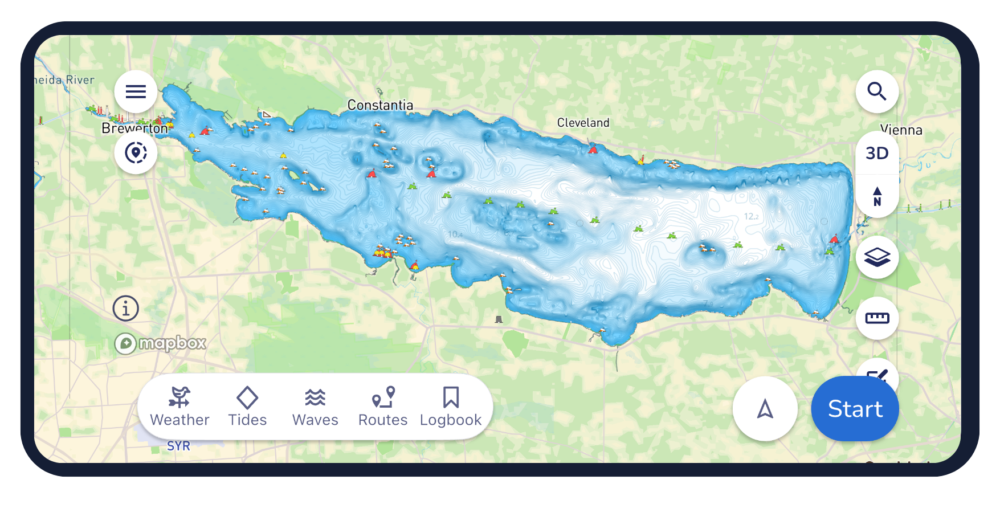
Marine navigation company Savvy Navvy has developed an in-house approach to processing and reconciling fragmented hydrographic data — combining official hydrographic data with expert geospatial data analysis to scale chart coverage faster and with greater accuracy.
The latest rollout adds more than 2,200 U.S. lakes and extends coverage into Estonia, Lithuania and Latvia in Europe, opening more waterways for boaters across the globe to explore. This comes not long after Danish charts from hydrographic offices were also added to the navigation app.
Prioritized by where boaters are most active, the latest update includes all major Minnesota lakes and expands lake coverage in 20 other U.S. states.
Elena Petru. (Credit: Savvy Navvy)
“Land mapping across much of the developed world, has benefited from sustained investment over several decades. Hydrographic data, the mapping of water, has a different history,” explained Elena Petru, geospatial data engineer at Savvy Navvy. “Survey cycles are longer, coverage is uneven, and for inland waters like lakes and reservoirs the situation is patchier still.
“Multiple authorities may hold overlapping or conflicting data for the same body of water, formats vary, and there is no single canonical source that can simply be downloaded and trusted. This fragmentation is exactly the challenge our geospatial team is solving through a structured reconciliation process.”
Petru joined Savvy Navvy in 2023, bringing her geomatics background from land data roles into the specific challenges of marine and inland water charting. Her expertise has enabled development of new data pipelines to overcome these marine charting challenges — marking a significant step in Savvy Navvy’s ongoing chart development program being based on unique, comprehensive data.
“You’d be surprised how often official sources do not fully line up. One of the main challenges is that the same lake can be represented slightly differently depending on the dataset. The task was not to pick one and apply it, but to compare sources carefully, understand where they differed, and make informed decisions about how each lake should be represented,” Petru said. “By going beyond official sources with our own expert validation process, we can integrate new regions faster while maintaining high data integrity, which overcomes one of the biggest difficulties in marine navigation. It’s exciting to see this data go live in the Savvy Navvy app knowing boaters can now use it on the water every day.
This approach forms part of Savvy Navvy’s broader data processing pipeline, enabling consistent, repeatable expansion into new regions. Through these data pipelines we can now deliver faster, more expansive chart coverage including waters not yet fully covered by official hydrographic surveys.
Savvy Navvy has been downloaded more than three million times globally. Unlike other boating navigation solutions, Savvy Navvy provides smart routing, giving users optimal routes and dynamic ETAs based on real-time data: departure time, chart information, weather conditions, tide, boat specifications and local regulations. The updated chart coverage is available across both the Savvy Navvy app and its integrated solutions.
Last month Savvy Navvy launched its new waves feature, turning complex wave data into a simple visual view that helps boaters understand how conditions will actually feel on the water. Worldwide chart coverage is available on all Savvy Navvy plans.
The U.S. commercial drone industry is at an inflection point. After years of incremental progress, the FAA’s landmark Part 108 Beyond Visual Line of Sight (BVLOS) rule is expected to take effect later this year, unlocking a new era of scaled commercial drone operations across delivery, infrastructure inspection, public safety, perimeter protection and beyond. It’s a pivotal moment for drone operators to get ahead of the most significant regulatory shift the commercial drone industry has seen.
Today, AirData UAV announced it is joining the Commercial Drone Alliance (CDA), bringing its operational platform into the industry’s broadest coalition for drone policy and progress. As a member of the CDA, AirData will actively contribute to the policies and standards that will define the next chapter of the U.S. drone economy through the CDA.
Part 108 introduces sweeping new operational requirements across pre-, during and post-flight documentation, personnel roles, risk-categorized operational areas, and mandatory continuous data reporting, and AirData’s platform is already built to meet them.
“We are at a critical moment for the drone economy,” said Lisa Ellman, Chief Executive Officer of the Commercial Drone Alliance. “As the industry moves toward broader BVLOS operations and frameworks like Part 108, access to scalable, reliable operational data such as that which AirData provides will help to safely unlock the full potential of the drone economy.”
Credit: AirData UAV
AirData’s platform delivers the tools operators will need to meet Part 108’s requirements, including: checklists, automated compliance documentation, flight logging across every mission, and fleet-wide analytics that give program managers visibility into operational risk. With more than 61 million flights across 450,000 pilots and 850,000 drones globally, AirData has been building the compliance infrastructure the industry now needs.
As the industry’s leading policy advocate, the CDA has been central to advancing the regulatory frameworks. The CDA is an independent non-profit organization led by key members of the commercialdrone industry. It works to educate policymakers and the public on the safe integration of drones into the national airspace and to advocate for policies that enable commercial drone operations.
“We have long served as the intelligence backbone for drone operations,” Eran Steiner, CEO and founder of AirData UAV. “We look forward to leveraging our data, insights, and experience to enable scalable, compliant, and mission-critical drone programs, particularly as frameworks like Part 108 unlock the next phase of scaled BVLOS operations in the United States.”
AirData’s platform gives public safety agencies, enterprise operators, and drone programs of every size the maintenance documentation, pilot currency tracking, asset management, checklist discipline, and operational data history that regulators will expect when Part 108 takes effect.
The U.S. Federal Aviation Administration (FAA) has issued a proposed rule that would allow specific categories of critical infrastructure sites to apply for restrictions on drone operations around their facilities.
The restrictions would be submitted and approved via a new FAA web portal. Approval will be based on safety or security criteria. Sixteen sectors would be eligible for restrictions including energy production, transportation systems, chemical facilities, water treatment plants, and defense industrial complexes.
The rule would establish two types of restrictions:
Standard Unmanned Aircraft Flight Restriction (UAFR): A general restriction that bars unmanned aircraft operations within a specific boundary, except for operators who have previously met rigorous safety and security standards.
Special Unmanned Aircraft Flight Restriction (UAF): A much more severe restriction that bars unmanned aircraft operations within a specific boundary for all operators unless they have the express prior approval from both the FAA and the sponsoring agency (for example, the Department of Homeland Security).
The restricted area would have clearly defined horizontal and vertical boundaries. Violators could face civil or criminal penalties.
The rule would also allow site operator to contact law enforcement if a drone flew in a restricted area, after which authorities can use Remote ID to locate the control station or operator. Pilots could face license suspensions, revocations, fines and criminal charges for entering these no fly zones.
Drone operators are encouraged to check B4UFLY for the latest breakdown on where pilots can and cannot fly.
Additional Information:
Restriction criteria includes impacts to aviation safety, protecting people and property on the ground, national security, or homeland security.
The full list of eligible site categories are:
Chemical
Commercial
Communications
Critical manufacturing
Dams
Defense industrial base
Emergency services
Energy
Financial services
Food and agriculture
Government services and facilities
Healthcare and public health
Information technology
Nuclear reactors, materials, and waste
Transportation systems
Water and wastewater
The comment period on the proposed rule will run until July 5, 2026.
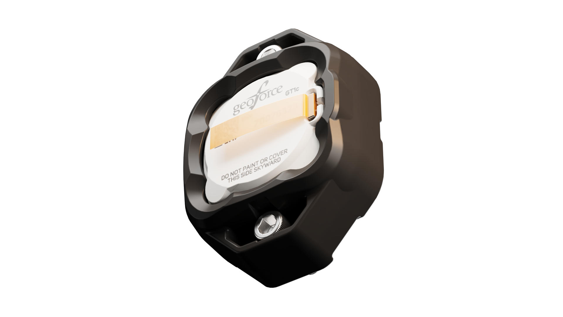
Geoforce has launched the GT1c, which enables rugged cellular equipment tracking at scale. According to Geoforce, the GT1c has a more cost-effective, purpose-built design to complement Geoforce’s full range of satellite tracking devices.
The GT1c operates on AT&T’s network, built for the next era of IoT connectivity for business. The device’s launch builds on a collaboration with AT&T Business announced in March and represents the first product outcome of the relationship.
The GT1c captures and feeds smart location updates to Geoforce’s mobile-enabled asset intelligence platform, providing field operations and asset managers with visibility into the location, movement and utilization of industrial assets and equipment.
The GT1c has an encapsulated design, reinforced bezel, and intrinsic safety certification to ensure that it can survive in hazardous, heavy-vibration environments and extreme temperature ranges. It’s low price means customers can afford to track almost every asset class, the company said.
Pilot programdemonstrates value
In a pilot program with Black Diamond Equipment Rental, the GT1c demonstrated that expanding tracking across mid-tier and small assets is both practical and operationally impactful. The heavy-duty equipment rental company expanded tracked inventory by 26% across smaller and mid-tier construction and oil and gas rental assets. The result was a significant reduction in operational friction and time savings expected to exceed 500 hours per year.
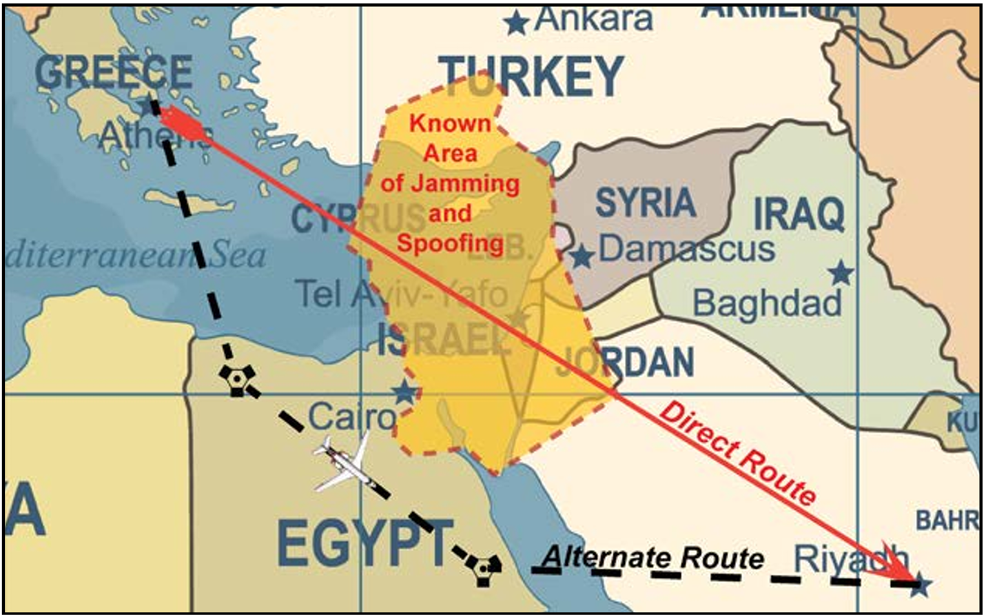
ICAO Secretary-General Juan Carlos Salazar told delegates at the 2026 World Overflight Risk Conference in Vallarta, Malta, that emerging military technologies — including long-range weapons systems, unmanned aircraft systems (UAS), GNSS radio frequency interference, and advanced air defense systems — pose growing risks to civil aviation.
“We must now reach beyond the boundaries of aviation as we have known it,” Salazar said, adding that increasingly sophisticated weaponry is creating conditions in which civilian aircraft face a heightened risk of being targeted or caught in crossfire.
While praising the aviation industry’s ability to reroute flights and maintain operations during the recent Middle East crisis, Salazar said operational flexibility alone cannot address the underlying security threats posed by weapons systems.
He commended states and airspace users for measures taken to mitigate safety and security risks during the escalation in the Middle East, noting that more than 10 states partially or fully closed their airspace, significantly disrupting international air transport.
“This commitment to resilience, adaptation, safety and security is the foundation of our industry,” he said, calling for concrete steps to prevent civil aviation facilities, airports and aircraft from being targeted.
Salazar cited ICAO Assembly Resolution A42-4 and Article 3 bis of the Chicago Convention — which prohibit the use of weapons against civilian aircraft — as the legal basis for stronger protections. He said, however, that international law alone has proven insufficient as regional conflicts intensify.
Following ICAO guidance, Salazar urged states to take three immediate actions: rapidly share threat intelligence when activities pose risks to civilian aircraft; strengthen risk assessment and timely decision-making; and improve coordination between military and civilian authorities to prevent misidentification of civilian aircraft as military targets.
ICAO is finalizing a Global Crisis Management Framework to coordinate responses when civil aviation faces threats. Salazar said the reactive framework must be paired with proactive measures to prevent attacks.
The organization is also updating its Manual Concerning Safety Measures Relating to Military Activities and its Risk Assessment Manual for Civil Aircraft Operations Over or Near Conflict Zones, with a focus on improving how authorities, airlines and air navigation service providers assess threats from malicious activity.
Recent disruptions during the Middle East crisis demonstrated both the industry’s adaptability and the economic impact of operating in an increasingly militarized airspace environment. ICAO regional contingency frameworks have supported rerouting when airspace becomes unsafe, but officials said such measures are costly and temporary, not solutions to underlying security risks.
The two-day Malta conference, which opened April 21, brought together aviation officials and security experts from multiple regions to discuss implementation of safety protocols and information-sharing mechanisms. The Safer Skies initiative also serves as a framework for those discussions.
Salazar’s remarks mark one of ICAO’s most direct acknowledgments of growing risks to civil aviation arising from conflict zones, reflecting the organization’s core mission to maintain safe and secure international air travel amid rising geopolitical tensions.
Following the conference, Salazar met with Myriam Spiteri Debono to discuss global and regional developments affecting aviation, with a focus on the role of multilateral cooperation in addressing emerging challenges, including conflict-zone risks. He also commended Malta’s aviation sector.
Salazar was accompanied by Nicolas Rallo, director of ICAO’s European and North Atlantic Regional Office.
FastXY can transform standard mobile devices into professional-grade data collection tools for geospatial information systems (GIS) and architecture, engineering and construction (AEC) professionals. FastXY offers professionals the ability to collect point, line and polygon data, and delivers advanced capabilities including 3D basemaps, construction staking, topographic surveying, on-the-fly datum transformations and survey-grade elevations. A built-in Bluetooth data parser allows users to configure the app to collect data from virtually any instrument supporting BLE Bluetooth or RS-232 — including echosounders, radiation sensors, laser rangefinders, barcode scanners and more — and marry that data instantly with precise GNSS coordinates. Available in free and premium versions.
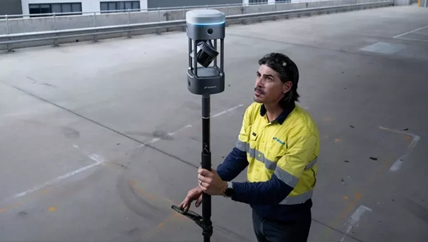
Handheld scanner: Designed for BIM, indoor scanning and reality capture
The RS7 handheld SLAM (simultaneous localization and mapping) scanning solution was built for BIM documentation, indoor surveying, renovation planning and complex spatial analysis. It is designed to help professionals capture high-density 3D data efficiently and convert it into practical deliverables through CHCNAV’s software and cloud ecosystem. The RS7 integrates a next-generation lidar scanner capable of measuring up to 1.15 million points per second. Its wide field of view (360° x 189°) supports comprehensive coverage of floors, walls and ceilings, helping reduce the need for repeated passes and complex capture maneuvers in tight or cluttered spaces. The scanner also includes a high-precision inertial measurement unit with bias stability better than 0.5°/h. By combining lidar and inertial data, the system is designed to maintain stable motion estimation and consistent point-cloud quality in environments that challenge many mobile workflows, including long corridors, repetitive structures, and feature-limited interiors.
Mobile scanner: All-in-one system offers SLAM, LIDAR, RTK and 360 degree imagery
The GX1 is an integrated, highly accurate all-in-one mobile scanning system combining simultaneous localization and mapping (SLAM), lidar, real-time kinematic (RTK) georeferencing, cameras and software. It supports a seamless workflow, from capture to deliverable, and can reduce the time required to survey a site by up to 95%. The independently validated global accuracy of 5 mm to 10 mm delivers the precision needed for topographic and road surveying, scan to building information models, construction progress tracking, and more. These capabilities are supported by integrated RTK georeferencing with real-time quality monitoring, four 20MP cameras for 360° panoramic imagery, and a proven SLAM algorithm. The GX1 has four deployment modes — backpack, survey pole, vehicle mount and supported handheld.
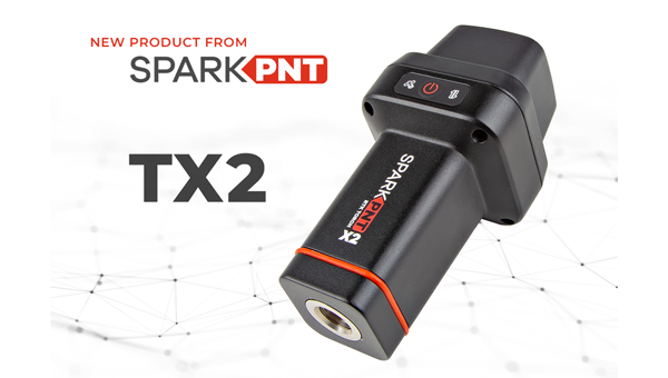
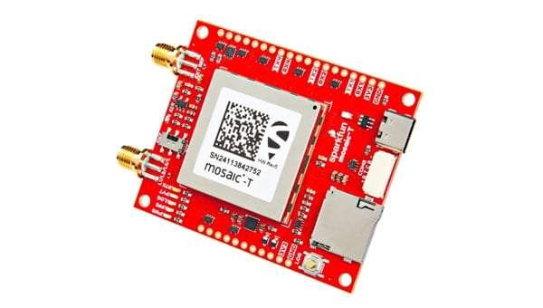
Quad-band GNSS rover: With support for Galileo high accuracy service
The SparkPNT TX2 quad-band GNSS rover combines an IP67-rated aluminum enclosure with support for Galileo’s High Accuracy Service (HAS) and standard RTK correction workflows. The receiver is built around the Quectel LG290P quad-band GNSS engine and supports multi-constellation tracking. Galileo HAS support provides sub-20 cm accuracy globally without subscription-based correction services, while RTK workflows via NTRIP or u-blox PointPerfect can achieve centimeter-level positioning. Battery life is rated at 50-plus hours, positioning the TX2 for multi-day field campaigns without recharging. The unit connects to iOS and Android devices via Bluetooth and WiFi, with compatibility reported for common GIS and data-collection applications. A notable design choice is the open-source firmware, which gives users visibility into how positioning data is processed and allows for customization and third-party integration. SparkFun has positioned this as an alternative to closed GNSS ecosystems where firmware and processing pipelines are not user-accessible.
Mobile
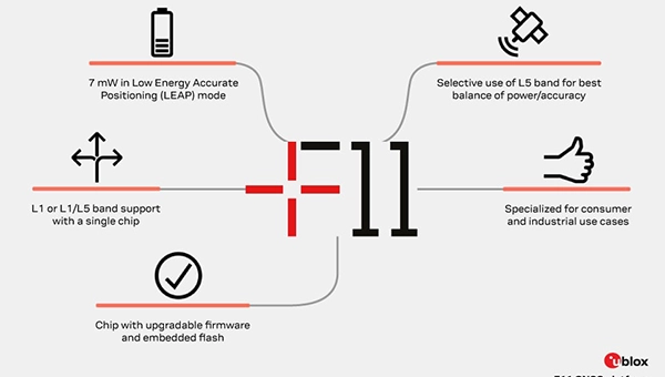
GNSS platform: Provides ultra-low power GNSS for all environments
The u-blox F11 platform provides L1/L5 dual-band standardprecision GNSS to improve positioning accuracy while reducing power consumption to as low as 7 mW in typical configurations. It combines ultra-low power operation with intelligent signal management to meet the evolving demands of tracking, wearables, telematics and mobility applications — including micromobility solutions and drones. The platform enables device manufacturers to achieve longer battery life, faster and more reliable position fixes, and greater design flexibility. Its situationally aware GNSS architecture, with integrated geofencing and indoor detections, dynamically balance accuracy and power consumption. By selectively using dual band L1/L5 operation only when it helps maintain positioning performance, the platform reduces energy use while providing resilience and maintaining confidence in location data.
The Iridium 9604 is a compact, threein-one internet of things (IoT) module that integrates Iridium short burst data satellite service, LTE-M cellular connectivity, and GNSS positioning into a single platform. The Iridium 9604 seeks to make dual-mode IoT connectivity viable for price-sensitive, high-volume deployments. Built on the u blox SARA-R5 platform, the module comes in a compact 16 mm x 26 mm x 2.4 mm form factor, suitable for dual-mode IoT deployments across industrial, infrastructure and mobility applications.
L1+L5 GNSS modules: For trackers and high-precision IOT
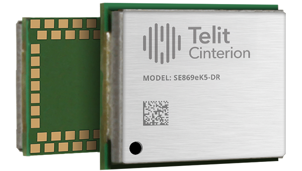
Two dual-band positioning modules built on Airoha’s AG3335 chipset series are available: the ultracompact SE873K5-D and the high-end SE869eK5-DRK. Both support space- and power-constrained IOT devices and use cases that require continuous, ultraprecise positioning. The modules provide a scalable path to adopt dual-band L1 + L5 GNSS.
Timing
Cesium-less clock: An alternative to cesium-accuracy holdover clocks
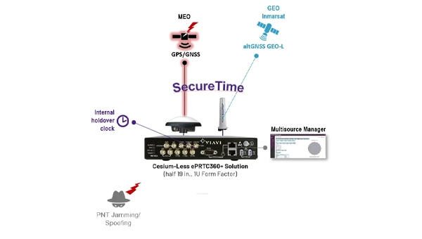
The patent-pending Cesium-less ePRTC360+ holdover solution is designed to safeguard atrisk infrastructure against the increased threat of GNSS timing disruptions. It is the only alternative to Cesium clocks to meet ITU-T G.8272.1 standards. It can protect critical power grids; transportation, aviation and public safety systems; 5G mobile networks; and AI data centers. It meets the international ITU-T G.8272.1 standard and has been successfully tested across a range of livesky defense and commercial jamming/spoofing environments. It has been integrated into VIAVI’s SecurePNT 6200 product series and can maintain 100 ns accuracy during GNSS-denied threats through the resilient altGNSS GEO-L service with no time limit.
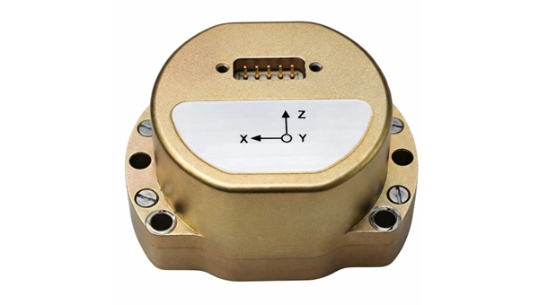
The U4930 series is a reliable and cost-effective six-axis microelectromechanical system (MEMS) and inertial measurement unit (IMU) module for navigation, control and measurement of vehicles, ships and drones. Applications include vehicle/ship attitude measurement, UAV attitude reference and trajectory control, mobile mapping, track inspection and underwater highprecision navigation. The U4930 series integrates high-performance MEMS gyroscopes and accelerometers within an independent structure. The three-axis MEMS gyroscopes sense the angular motion of the carrier, and the three-axis MEMS accelerometers sense the linear acceleration of the carrier. The system internally performs compensation for zero bias, scale factor, non-orthogonal error and acceleration-related terms across all temperature parameters, maintaining high measurement accuracy over a long period of time. The module supports custom communication protocols and provides synchronization for GPS/GNSS time data and pulse per second (PPS) signals.
Underground navigation: For navigating mines and unmapped environments
Chimera Land is a 3D laser velocity sensor (LVS) designed to solve the primary challenge for underground mining: maintaining precise vehicle positioning in deep, dark and unmapped environments where GPS cannot reach. When fused with an Advanced Navigation inertial navigation system (INS), Chimera Land allows underground vehicles to maintain stable navigation over extended distances and time. Instead of needing to query an external beacon or satellite for its location, the sensor uses specialized lasers to measure a vehicle’s ground-relative 3D velocity with high accuracy. By feeding this precise data into the vehicle’s INS, the sensor eliminates the drift that typically comes with standalone INS. Using AdNav Intelligence, the result is a resilient, high-performance, infrastructure-light positioning solution that excels in the highdust, zero-light conditions typical of underground mines.
Simulators
GNSS test tool: Provides real-world testing with signals from the field
The SimXTRACT GNSS test tool bridges the gap between field and laboratory. It enables signals captured in field environments to be comprehensively decomposed into individual, discrete signals and applied to lab simulation for realism at every stage of the development test cycle. Developers usually rely on either RF record-and-playback or lab simulation for testing and validation of PNT systems and devices. SimXTRACT takes real signals captured in field environments and performs complex signal decomposition, breaking down each received signal into discrete line-of-sight and multipath ray paths, along with metadata such as Doppler offset, code error, power level and angle of arrival. This decomposed environment is then automatically converted into fully controllable simulation scenarios for Spirent GNSS simulators.
Autonomous
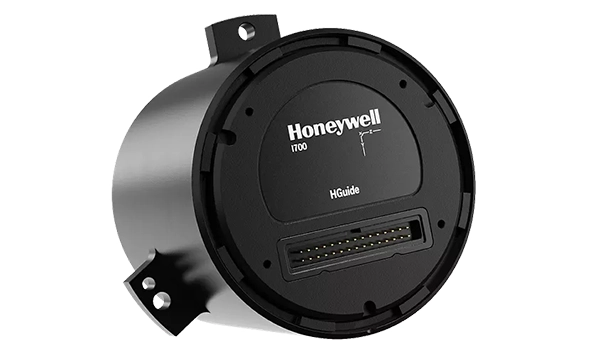
Inertial measurement unit: For unmanned air, land and sea
Honeywell launched the HGuide i700, an inertial measurement unit (IMU) that delivers high-accuracy performance for unmanned air, land and sea vehicles. By pairing near navigation-grade capability with a nolicense-required (NLR) classification, the HGuide i700 provides integrators worldwide with a new option for critical sensing and navigation. The HGuide i700 uses high reliability sensors and electronic architecture found in Honeywell’s HG3900 inertial measurement unit (IMU). Compact and low power, the HGuide i700 delivers near-navigationgrade accuracy and reliability while being optimized to support longer range navigation in GNSS-denied environments. The HGuide i700 offers strong GNSS-denied performance for by limiting maximum acceleration and spin rates in a license-free package. The latest in Honeywell’s HGuide suite of no-license inertial solutions, the HGuide i700 allows customers to streamline development cycles, simplify system architecture and transition to field deployment quickly. The HGuide i700’s rugged design, compact size and low-power profile make it suitable for diverse commercial, industrial and defense applications, including autonomous vehicles, mapping and surveying.
Anti-jam antenna system: Provides multi-constellation, multi-frequency GNSS signal protection
The GAJT-AE3 protects all major GNSS constellations from jamming with full multiconstellation, multi-frequency coverage, ensuring reliable PNT in demanding airborne environments. Its antenna electronics mitigate interference by creating up to seven nulls per band in the direction of jammers, providing significant anti-jam protection even in dynamic multi-jammer scenarios. The output is a protected radio frequency signal, free from jamming and suitable for input to modern and legacy GNSS receivers. The GAJT-AE3 protects and supports all GNSS frequencies, including L-band corrections and Iridium PNT.
OEM
GNSS board: All-band multifrequency reception and HAS-ready
Syslogic’s new all-band GNSS expansion board for rugged embedded computers is powered by the u-blox X20 receiver. It supports all major GNSS constellations and frequencies, including L1, L2, L5, L6 and L-band, and enables the use of the Galileo High Accuracy Service (HAS). It provides centimeter-level positioning, opening up new applications across industries such as autonomous field management, operation of construction machinery in remote areas, or navigation of automated guided vehicles and autonomous mobile robots. The GNSS board is designed for worldwide use. The integrated u-blox receiver supports modern correction techniques such as RTK, PPP-RTK and PPP. For the first time, it has been fully optimized for PointPerfect Global, u-blox’s proprietary high-precision GNSS correction service, delivering centimeter-level positioning anywhere in the world. This is particularly useful in remote areas without cellular coverage.
GNSS L1/L5 breakout: For meter-level positioning in embedded applications
The SparkFun GNSS L1/L5 Breakout – NEO-F10N (SMA) is a compact GNSS module designed for meter-level positioning accuracy in embedded applications. It uses dual-frequency L1 and L5 bands, with the L5 signal offering improved performance in urban environments due to reduced RF interference within the protected ARNS spectrum.
The board supports concurrent reception of GPS, Galileo and BeiDou, and uses u blox dual-band multipath mitigation to enhance accuracy in challenging conditions. It features a single UART interface, with an onboard CH340 USB-to-serial converter for easy connection to a computer, and standard pin headers for integration with external systems.
The module includes an SMA connector for secure antenna attachment and is configurable using u-blox u-center software.
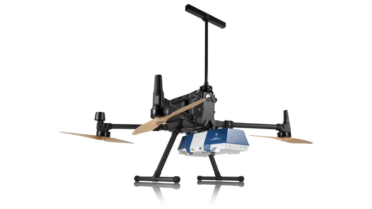
The 23rd International Flight Inspection Symposium (IFIS) will gather experts in San Salvador May 4-8. There, Rohde & Schwarz will demonstrate its test and measurement solutions for ground-based navigation aids. The exhibits address the rising traffic volumes and stricter safety requirements.
Rohde & Schwarz will take part in the conference’s technical sessions with a presentation on “Challenges for UAV Operations in RF Dense Aerodrome Environments.”
The aviation sector today faces increasing air traffic density, rapid technological advancements and heightened security concerns, the company explained. Operators need test equipment that delivers laboratory level precision while tolerating the harsh environment of an airport runway or a remote navigation site.
Among the exhibits at the Rohde & Schwarz booth is the R&S EVSD1000 VHF/UHF Nav/Drone Analyzer, designed to conduct GBAS, ILS and VOR measurements in line with ICAO Doc 8071 and ICAO Annex 10. The receiver delivers laboratory precision, supports an air to ground Wi‑Fi datalink and gapless measurements with improved location accuracy during flight inspections. Customers benefit from a device that can be mounted on a drone, reducing the need for manned flights and lowering operational expenses.
Rohde & Schwarz gives airlines, airport operators and navigation service providers a reliable way to certify and maintain ground‑based aids under today’s demanding conditions. By combining high measurement accuracy, easy operation and durability, Rohde & Schwarz aims to help the industry keep pace with growth.
Deepen AI has released its latest targetless calibration platform, built to simplify and accelerate calibration for complex autonomous vehicles, automotive ADAS and robotics sensor suites.
The platform supports a wide range of configurations including GNSS receives, multiple lidars, radars, cameras and inertial measurement units (IMUs). It processes all inputs in one pass using a single continuous dataset such as a ROS bag.
As sensor stacks become more sophisticated, traditional calibration methods are increasingly becoming a bottleneck in deploying autonomous systems at scale. These approaches are often manual, iterative and dependent on physical targets. Deepen AI’s solution introduces a fully automated and unified approach that calibrates all sensors simultaneously.
The platform estimates intrinsic, extrinsic and temporal parameters across the entire sensor suite in a single streamlined workflow, removing the need for sensor-by-sensor calibration. This approach streamlines operations while delivering high performance, achieving up to 0.05° angular accuracy and 0.7 cm positional accuracy, exceeding traditional target-based calibration techniques.
Capabilities include:
Simultaneous calibration across all sensors using a single dataset
Support for multi LiDAR, camera, radar, IMU, and GNSS configurations
Accuracy of up to 0.05° and 0.7 cm
No strict requirement for loop closure or fixed driving patterns
“Calibration has traditionally been one of the most time-consuming, complex and fragmented steps in deploying autonomous systems,” said Mohammad Musa, founder and CEO of Deepen AI. “With this release, teams can move to a system level approach that delivers both speed and precision using real-world data.”
The system is designed to work without controlled environments or rigid data collection protocols, allowing teams to seamlessly integrate calibration into existing workflows for both research and large-scale production deployments. It requires only simple and practical conditions, with calibration possible in locations such as parking lots, garages or quiet streets, provided the environment is mostly static with minimal moving objects. A minimum of 30 seconds of continuous driving data is required.
The platform is already being deployed with customers working on highly complex sensor configurations, where multiple lidars and cameras need to be calibrated together as a single system. In one such deployment, the full sensor stack was calibrated during a normal drive in a parking garage, parking lot, or a small residential street, without any special driving patterns or looped trajectories.
Using only a short duration of driving data, Deepen AI simultaneously performed intrinsic, extrinsic and temporal calibration across all sensors in a single workflow. This unified approach not only simplifies operations and improves consistency, but also delivers accuracy that surpasses traditional target-based calibration methods, making it well suited for both research and production environments.
The U.S. Federal Aviation Administration (FAA) has updated its GNSS Interference Resource Guide with updated information on GNSS vulnerabilities and general edits throughout.
The FAA’s Flight Technologies and Procedures Division (AFS-400) developed the guide to provide U.S. operators and pilots with the most current information regarding GPS and GNSS jamming and spoofing.
According to the guide’s introduction, “The impacts of safety hazards from GNSS interference rapidly spread over the past few years and is persistent. As the threat of GNSS jamming and spoofing is constantly changing, the FAA will update this resource guide to provide the best guidance in the rapidly changing environments.”
Viavi’s Secure µPNT STL-1000 is a compact software-defined receiver designed to operate with the Viavi SecureTime altGNSS LEO services. Delivering precise timing with holdover capability, it enables tracking, authentication and assured navigation in denied, degraded and disrupted space operational environment, also known as D3SOE.
“With jamming and spoofing now a core element of cyber warfare, resilient PNT solutions are no longer optional,” said Doug Russell, senior vice president and general manager, Aerospace and Defense, Viavi. “The Secure µPNT STL-1000 enables assured, uninterrupted operations, especially in contested environments. Its compact size and low power consumption makes it ideal for applications that require an extremely small, low-power, secure, resilient embedded PNT receiver.”
“As the frequency of jamming and spoofing continues to rise, reliance on GPS/GNSS signals alone increasingly exposes both commercial and military operations to risk,” said Alastair MacLeod, CEO of Ground Control. “Integrating Viavi’s Secure µPNT STL-1000 into RockFLEET Assured delivers a trusted secondary position source, strengthening resilience for mission‑critical operations across defense, maritime and critical infrastructure environments.”
RockFLEET Assured is a marine-grade assured position, navigation and timing (A-PNT) solution designed to support maritime vessel navigation and oversight in GNSS-denied environments.
ArkEdge Space successfully launched its micro-satellite AE1a on March 30, and has begun initial checkout following the establishment of communications through test radio signals.
AE1a is a technology demonstration satellite developed to advance maritime digitalization by enabling wide-area, real-time vessel tracking and communications. The satellite adopts ArkEdge Space’s standardized 6U satellite bus in its large-antenna configuration. In addition to demonstrating a deployable antenna for VDES (VHF Data Exchange System) applications, AE1a will improve and validate core technologies for a VDES receiver.
AE1a will operate in coordination with AE1d, which began operations in January 2025, and AE3Va, which began operations in June 2025, forming a three-satellite constellation for demonstration across wide-area maritime areas.
AE3Va continues to acquire AIS signals across multiple sea areas, including waters around Japan and vessel-congested areas along critical shipping lanes. Accumulated reception data is being systematically verified and analyzed.
Going forward, the program will advance from reception-focused demonstration to two-way communications, including transmission from orbit. This will enable satellites to deliver operational information directly to vessels, expanding the scope of VDES demonstration and advancing progress toward concrete use-case validation across the maritime sector.