A FreeFlight Systems SBAS/GNSS receiver has been selected to provide ADS-B position source information as a part of an upcoming ADS-B modification and compliance program for the United States Air Force HH-60G helicopter fleet.
Strategic Enterprise Solutions Corp. (SESC) of Warner Robins, Georgia, was awarded the modification program, which includes installation of the 1203C SBAS/GNSS receiver and the AN/APX-119 Mode S Extended Squitter transponder with Mode 5 capability to provide a complete ADS-B Out solution for more than 100 helicopters.
An HH-60 Pave Hawk helicopter lands in Afghanistan; a UH-60 Blackhawk is in the background. (Photo: U.S. Air Force photo/Senior Airman Brian Ferguson)
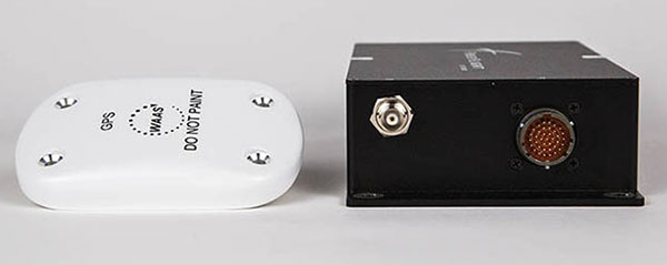
The FreeFlight Systems 1203C SBAS/GNSS receiver is a certified, high-integrity position source in a compact, lightweight package that was designed to be modular and able to be integrated with various other avionics.
The 1203C pairs seamlessly with certified Mode S Extended Squitter transponders for a fully rule-compliant ADS-B Out system, FreeFlight said.
More than a war hawk. The primary mission of the HH-60G Pave Hawk helicopter is to conduct day or night personnel recovery operations into hostile environments to recover isolated personnel during war.
The HH-60G is also tasked to perform military operations other than war, including civil search and rescue, medical evacuation, disaster response, humanitarian assistance, security cooperation/aviation advisory, NASA space flight support, and rescue command and control.
The 1203C in service. With several hundred 1203Cs in service across airline transport, military, business aviation and rotorcraft platforms, these receivers are known for their high performance, ease of installation, operational reliability and longevity, FreeFlight said.
The 1203C SBAS/GNSS receiver and antenna (Photo: FreeFlight Systems)
The 1203C can also serve as the approved position source for select manufacturers of TAWS/FMS, RNP and other NextGen applications, and allows customers to take advantage of the operational and safety benefits provided by the NextGen airspace transformation without the need for extensive and costly avionics upgrades.
With the ADS-B mandate now only 17 months away, aircraft operators need to prioritize ADS-B installations.
Significant portions of today’s airline, business, and military aircraft fleet will remain in service long after 2020, and in many cases an STC’d retrofit solution comprising of a transponder upgrade and the addition of a dedicated SBAS/GNSS receiver like the 1203C is the simplest and most cost-effective way to achieve mandate compliance, FreeFlight said.
NXP Semiconductors N.V. has announced the next phase in its Smart City collaboration with Columbus, Ohio, the winner of the 2016 U.S. Department of Transportation’s $40 million Smart City Challenge.
NXP will contribute key technologies for smart and safe mobility to the Smart Columbus Experience Center.
Smart Center. On June 30, the City of Columbus celebrated the opening of its Smart Columbus Experience Center. The center allows visitors to see how new mobility options, such as connected, autonomous, shared and electric vehicles, will help make Columbus a more connected community.
Hands-on educational experiences and technology demonstrations aim to show visitors how technology and innovation in transportation can grow the local economy and create ladders of opportunity for central Ohio residents.
Visitors to the Smart Columbus Experience Center will learn how Vehicle to Everything (V2X) Technology allows cars to communicate with each other as well as with intelligent traffic infrastructure to keep mobility safe and efficient. (Image: NXP USA)
Cohda Wireless. As part of the Smart Columbus Experience Center initiative, NXP and Cohda Wireless will deploy a connected vehicle environment through the center’s electric vehicle test drive area so drivers can experience this future technology in person.
NXP has also donated an electric motorcycle with an accompanying drone that alerts the driver to dangers or delays ahead.
Key smart city technologies
As part of its commitment to Columbus, NXP will continue to contribute key mobility technologies to the Smart Columbus Experience Center, including:
NXP’s RoadLINK V2X technology allows cars to communicate with each other as well as with intelligent traffic infrastructures. The IEEE802.11p Dedicated Short Range Communications (DSRC) standard allows cars to securely connect to each other as well as to infrastructure. DSRC technology is the only ADAS sensor that can look around the corner and offers lowest latency in the communication.
Smart Card IC technology that enhances transportation for all citizens by supporting secure and convenient public transportation ticketing and payment systems, including contactless transit fare solutions.
Highly secure NXP Radio Frequency Identification (RFID) solutions designed to promote public safety and convenience. Smart City applications for this NXP technology include vehicle window stickers that enhance driver convenience and reduce municipal costs by eliminating the need for stop-and-pay stations in public parking spaces.
NXP eBike and Drone demo at the new Smart Columbus Experience Center shows how drones could send real-time video of a traffic incident to a city emergency vehicle. (Image: NXP USA)
Concept of Operations released
Smart Columbus, the smart city initiative from the City of Columbus, in July released the Concept of Operations for its Connected Vehicle Environment (CVE) pilot.
The Concept of Operations outlines in detail how the CVE pilot will be implemented over the next two years. The pilot will involve:
113 road side units (RSUs) that will be installed at intersections with stoplights
up to 1,800 on-board units (OBUs) that will be installed on participating private, emergency transit and freight vehicles, and
12 vehicle-to-vehicle or vehicle-to-infrastructure applications that will be deployed, according to the document.
Goals of the CVE pilot include improvements of:
vehicle operator safety
intersection safety
school zone safety
reliability of transit vehicle schedule adherence
emergency vehicle response times
traffic management capabilities.
Smart city demonstrations. Visitors to the Smart Columbus Experience Center can try out electric automobiles. A fleet of six electric vehicles will be on display and is available for test drives through a connected vehicle environment provided by NXP and Cohda Wireless.
Vehicles on display or available for test drives include:
a BMW i3 provided by BMW
a Chevrolet Bolt provided by Dave Gill Chevrolet
a Honda Clarity provided by Honda
a Mercedes-Benz GLE 55e provided by Daimler
a Nissan LEAF provided by Nissan North America
a Toyota Prius Prime provided by Toyota.
An electric motorcycle provided by NXP and a Ford Ojo electric scooter are also on display.
Ford has applied for a patent that would send a drone to dock with an autonomous vehicle and act as a surrogate sensor if one of the car’s sensors failed. The UAV then uses its own sensors to guide the car to a repair facility.
A UAV docks with a car. (Diagram: Ford’s patent application)
The filing from Ford Global Technologies, a subsidiary that manages and commercializes patents and copyrights, outlines the process.
Once the vehicle registers a fault in one of its sensors, it uses a vehicle-to-vehicle (V2V) network to summon the drone, which flies to the vehicle, receives authorization, and then lands atop it. The UAV then serves as a replacement sensor while directing the vehicle to a nearby repair center to fix the car’s sensor.
Ford developed the technology to aid autonomous vehicles that have lost a critical navigation sensor; autonomous cars use GNSS, short- and long-range radar, lidar, cameras and ultrasound.
The European Union (EU) project BLUEGNSS has been developing GNSS applications in selected European airports to increase safety and airport accessibility, according to the European Commission’s Community Research and Development Information Service (CORDIS).
BLUEGNSS’s focus has been on advancing the adoption of the Galileo system in Greece, Italy, Cyprus and Malta. The four countries together form the Blue Med functional airspace block (FAB): airspace in which air traffic is managed irrespective of national boundaries. Blue Med is one of the nine FABs formed in Europe to reduce the fragmentation of the European air traffic network.
Three-dimensional GNSS approaches are being designed for 11 airports in the Blue Med FAB: four each in Greece and Italy, two in Cyprus and one in Malta.
The primary aim is to harmonize the implementation of required navigation performance approaches among the four countries, CORDIS said. This will enable aircraft to fly along precise flight paths with greater accuracy, and will make it possible to pinpoint aircraft position with precision and integrity.
Three new procedures. So far, substantial progress has been made towards safety and airport accessibility in the target countries. Since the beginning of 2018, three new GNSS procedures have been validated for Italian airports Cuneo, Lamezia and Parma, followed by another two for Larnaca and Paphos in Cyprus.
The poor weather conditions under which the Cyprus GNSS approaches were validated served to demonstrate the benefits of GNSS vertical guidance. Since its launch in 2016, BLUEGNSS has designed and validated 14 GNSS procedures.
Augmented performance of Galileo has been achieved through the European Geostationary Navigation Overlay Service (EGNOS). EGNOS is a satellite-based augmentation system that improves GNSS positioning. Its three satellites and network of more than 39 reference stations in 24 countries enable it to provide greater accuracy than Galileo alone.
EGNOS’s safety advantages and lower investment costs greatly benefit small and regional airports, which usually can’t afford the high costs of installing and maintaining ground-based navigation aids.
For this reason, BLUEGNSS has promoted its use in this geographically challenging Mediterranean region.
“The southeast Mediterranean region lacks full EGNOS coverage,” said GNSS expert Patrizio Vanni of ENAV S.p.A., project coordinator and Italy’s air navigation service provider. “To make things even more challenging, each airport involved in the project presents a very different operational environment.”
The project hasn’t only focused on designing and validating GNSS approaches at airports where no such procedures have been available up to now. It has also provided the necessary training and monitoring to support implementation by the Blue Med FAB countries.
Now close to completion, BLUEGNSS (Promoting EGNSS Operational Adoption in Blue Med FAB) is the first project of its kind to be coordinated at FAB level. It may serve as a catalyst to spread required navigation performance approach know-how in the region and beyond, to the whole of Europe.
Comtech Telecommunications Corp. has been awarded $1.9 million navigation contract by a U.S. automotive manufacturer, according to the company. The automaker’s identity was not revealed.
The contract is with Comtech’s Enterprise Technologies group, which is part of Comtech’s Commercial Solutions segment, and is for developing a new navigation product for two of the automaker’s top vehicle programs, including motorcycles.
“With this agreement, our turnkey navigation solution will be introduced to an entirely new automotive segment and is included as a lead product for this manufacturer supporting multiple languages and is deployed globally across all major markets,” said Fred Kornberg, president and chief executive officer of Comtech Telecommunications Corp. “It also represents a new stage of growth for our navigation and mapping applications, made possible through our Location Studio platform that has been a leading source of product customization for OEMs across a number of vertical markets.”
The Enterprise Technologies group specializes in precise device location and messaging platforms. Its fully virtualized and API solutions are available to mobile network operators, enterprises, internet of things (IoT) developers and automotive manufacturers.
Comtech Telecommunications Corp. designs, develops, produces and markets innovative products, systems and services for advanced communications solutions. It sells products to a diverse customer base in the global commercial and government communications markets.
By Gustavo Lee and Mathieu Joerger, Aerospace and Mechanical Department, The University of Arizona Presented at ION/IEEE/PLANS 2018
This paper describes the design and implementation of a new safety risk evaluation method for a sensor-based automotive collision warning system using vehicle-to-vehicle (V2V) communication. It provides an overview of the V2V basic safety message (BSM) format and of surrogate measures of safety (SMS) used to parameterize a vehicle encounter. BSM and SMS are then employed to quantify risk of collision and risk of false alerts. Preliminary simulations illustrate the methodology in an example multi-sensor intersection movement assist system.
The U.S. Federal Communications Commission has allocated 75 MHz of licensed spectrum in the 5.9-GHz band for use by Intelligent Transportation Systems vehicle safety and mobility applications. In addition, in the Society of Automotive Engineers (SAE) J2735 Standard, the DSRC committee specifies a set of messages and their formats to support vehicle-based applications. Of particular relevance to this work is the BSM, which conveys critical vehicle-state information that includes vehicle position, positional accuracy, speed, heading, braking status and size.
V2V communications using DSRC have an operational range of about 300 meters. Within this range, V2V applications have the potential to significantly reduce occurrences of crashes through real-time advisories, alerting drivers to imminent hazards. GPS and GPS/INS-based relative positioning using V2V is subject to alteration and loss of GPS signal. But unlike vehicle-resident sensors (such as cameras and lidars), GPS/INS/V2V is not affected by weather, light or dust, and can sense out-of-sight vehicles occluded behind other vehicles or around building corners. This capability addresses scenarios where an oncoming vehicle emerges from behind a truck or from a blind alley. In those situations, GPS/INS /V2V can sense threats that a radar or camera cannot.
The SensLynx GPS Management Accelerator Program (GMAP) can enable start-ups or enhance existing business portfolios with the addition of tracking solutions, the company said.
GMAP requires no upfront investment or inventory warehousing, and is structured to deliver recurring revenue via new sales channels, while also being compatible with legacy business models to capitalize on similar customer profiles.
Because SensLynx white labels its solutions under certain criteria, entrepreneurs earn significant margin on hardware sales, plus monthly subscription income from the customers they will own outright.
“We believe in the entrepreneurial spirit,” said Rob Garry, co-founder and CEO of SensLynx. “Not only does this Accelerator Program help us grow our IoT Fleet sector on a grass roots level, it inspires others to strike out on their own or expand.”
The GMAP program is built around SensLynx’s bundled solution components, which include Fleet & Asset Tracking, Electronic Logging Device, Routing Application, Video/DashCam capture and Workforce Management for smartphones.
At its heart is comprehensive fleet/asset tracking software, packed with features like data handling, parsing, database, mapping, alerting, reporting, dispatch, maintenance logging, e-logs, local posted speed limits, addressing, geofencing, interstate miles, open API-based software and more.
The complete bundled solution with software, hardware and data connectivity is packaged at one guaranteed monthly price.
Senslynx’s GMAP program includes initial training, planning for rollout, conducting telemarketing for launch, developing website content, providing custom-branded marketing materials and online demo support, accessible through the streamlined GMAP Reseller Portal where businesses can also easily manage supply chain and customer accounts.
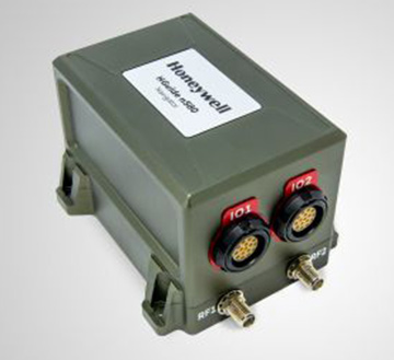
Honeywell has produced a new inertial navigation unit that provides accurate navigation for customers across a broad range of industries including agriculture, robotics and autonomous vehicles, without compromising on size, cost or performance.
The HGuideN580 inertial navigation technology improves accuracy in urban and rural environments. (Photo: Honeywell)
The HGuide n580 is the first Honeywell-produced, industrial-focused navigation solution that uses both precision inertial measurement unit technology and GNSS to improve location accuracy even when facing natural and manmade obstacles.
“The blend of inertial and satellite navigation capabilities provided by the HGuide n580 is especially important where precision is required in demanding environments — for example, autonomous cars traveling in cities, where our technology can extend the accuracy and performance of navigational systems while keeping passengers safe,” said Chris Lund, senior director, Navigation and Sensors, Honeywell Aerospace. “Honeywell’s history and expertise in navigation technology enables customers to implement this new wave of advanced technology into their own applications and operations.”
Roughly the size of a deck of cards, the HGuide n580 gives Honeywell’s industrial customers the capabilities needed to navigate accurately in areas with limited satellite coverage, such as densely populated cities where tall buildings, underground tunnels, and multi-layer freeway stacks or bridges often create challenges to traditional GPS navigation.
For a GPS unit to function properly, it requires a strong signal connection between the unit on the ground and multiple satellites in the sky to accurately orient its position. City infrastructure such as buildings and tunnels can temporarily block the signal between GPS unit receivers and satellites, creating urban canyons.
With the HGuide n580 integrated system, Honeywell’s inertial measurement unit technology combines with GPS to act as a backup solution, which means the loss of GPS signal caused by an urban canyon does not result in a complete loss of navigation.
To learn more about the new HGuide n580 solution and Honeywell’s other commercially available navigation technologies, visit the Honeywell Aerospace website.
The Connected Citizens Program, a two-way sharing of publicly available traffic and road condition information, offers governments a stream of data, constantly updated in real-time, whenever they need it. This enables personnel to make data-driven infrastructure decisions and improves the efficiency of incident response.
Waze, a free crowdsourced traffic and navigation app, is now fully supported by ArcGIS Online, where its live feed of mapped traffic alerts and other information, such as accidents, congestion and street damage, can be used in applications in minutes.
“Municipalities can now leverage near up-to-the-minute reports without having to write code or purchase additional software,” said Andrew Stauffer, manager of civic technology at Esri. “Mapped Waze data is available immediately in all ArcGIS apps, where traffic engineers and even city planners can use it to maintain and build safer, more efficient transportation systems.”
Municipal personnel like traffic engineers can start using this data to analyze where the biggest problems exist on the roads so they can create targeted solutions. For instance, by seeing exactly where the most crashes are occurring, engineers can know where they need to place more officers, replace street signs, or adjust the timing of traffic lights.
“The Waze Connected Citizens Program is all about removing any barriers to innovation,” said Adam Fried, Waze Global Partnerships manager. “We want to help our partners leverage existing infrastructure and be able to make better data-driven decisions. Now, with just a couple of clicks, a city can easily access and analyze Waze data within Esri ArcGIS and use those insights to improve roadway management and build safer roads for its citizens.”
Much of the information government organizations rely on to make decisions is becoming obsolete as communities are starting to use technology like sensors and drones to monitor the quality of roads, bridges, and utilities. The Waze Connected Citizens Program gives municipalities the power to harness crowdsourced driver data to not only improve safety and congestion but also make better-informed decisions by giving planners an edge to start building infrastructure that meets the demands of a twenty-first-century city.
Governments can sign up for the free Waze Connected Citizens Program and start working with the alert data in ArcGIS to create operational dashboards that departments can use right away.
The Association for Unmanned Vehicle Systems International (AUVSI) has formed an Unmanned Maritime Systems (UMS) Advocacy Committee to focus on the development of policy positions to support the advancement of the industry.
“Unmanned maritime systems allow military and commercial operators alike to go farther and deeper than ever before,” said Brian Wynne, president and CEO of AUVSI. “The input provided by the UMS Advocacy Committee will help us speak with a unified voice and enable all our members to advocate for the growth of the industry.”
The UMS Advocacy Committee will be chaired by Thomas Reynolds, vice president of business development for Hydroid Inc./Kongsberg Maritime. Reynolds, who leads all Kongsberg Maritime business with the U.S. government, previously served as a commissioned officer in the U.S. Navy, where he served as commander of the Explosive Ordinance Disposal Task Group, U.S. Fifth Fleet, among other roles.
Reynolds holds a bachelor of science degree from the U.S. Naval Academy and an executive master of business administration from Benedictine College.
Wayne Prender, vice president for Applied Technology and Advance Programs at Textron Systems, will be the committee’s vice chair. In his role at Textron, Prender is responsible for engineering development programs, advancing areas such as the Common Unmanned Surface Vehicle and Cased-Telescoped Weapons and Ammunition, as well as emerging capabilities and development programs.
Prender is a former commissioned officer in the U.S. Army, where he was deployed to Iraq and awarded the Bronze Star. He holds a bachelor’s degree in mechanical engineering from St. Louis University, a master’s degree in technology management and a master of business administration from the University of Maryland University College.
The committee also includes representatives from BAE Systems, L3 Technologies, Leidos, Lockheed Martin, Northrop Grumman and Seaborn Defense.
The UMS Advocacy Committee formalized a set of policy priorities to help guide the committee’s legislative and regulatory actions. The priorities state that the committee shall:
Establish the UMS Advocacy Committee as the preeminent industry voice influencing acquisition and regulatory policies and processes.
Facilitate the growth of UMS through active engagement with the government and commercial sectors.
Collaborate with ship owners, operators, shipyards, ports, federal maritime agencies, technology developers, classification societies and academia to further integrate advanced automation for maritime platforms into the domestic market.
Develop the future of the UMS workforce through technology-focused education.
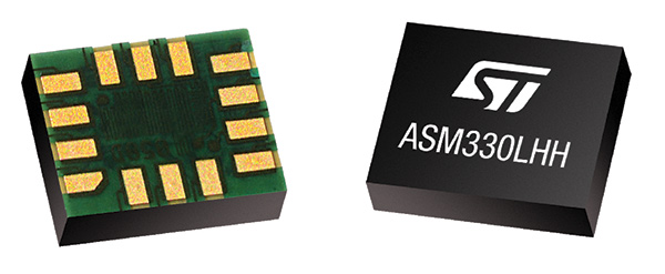
STMicroelectronics has introduced the automotive-grade ASM330LHH six-axis inertial sensor for super-high-resolution motion tracking in advanced vehicle navigation and telematics applications.
Photo: STMicroelectronics
Serving demands for continuous, accurate vehicle location to support automated services, the ASM330LHH lets advanced dead-reckoning algorithms calculate precise position from sensor data if satellite signals are blocked, such as in urban canyons, tunnels, covered roadways, parking garages or dense forests.
Its advanced, low-noise, temperature-stable design enables dependable telematics services such as e-tolling, tele-diagnostics and e-Call assistance. Precision inertial data in six axes also meets the needs of advanced automated-driving systems, the company said.
Automotive component manufacturer Magneti Marelli has selected the ASM330LHH for advanced telematics systems, to be fitted as original equipment by global automotive groups in upcoming vehicle ranges.
For the ASM330LHH, as with all its MEMS sensors, STMicroelectronics owns the entire manufacturing process, from designing the sensors, through wafer fabrication, packaging, test, calibration and supply. Full end-to-end control enables STMicroelectronics to create high-performing sensors and assure customers of a robust and responsive supply chain, with rigorous end-of-line quality screening, the company said.
“STMicroelectronics is the largest supplier of MEMS sensors for automotive non-safety applications, such as navigation and telematics,” said Andrea Onetti, Analog, MEMS and Sensors Group vice president at STMicroelectronics. “Our latest-generation inertial sensor, the automotive-grade ASM330LHH, enables precise positioning for safer, smarter driving.”
Engineering samples will be available for evaluation by the third quarter of 2018, and volume production will begin the following quarter.
Further technical information on the ASM330LHH
Temperature range up 105 degrees Celsius giving designers extra freedom to locate electronic controls in hot areas such as in smart antennas on the vehicle roof, or near the engine compartment.
Ultra low noise allows greater measurement resolution by minimizing integration errors when positioning is reliant on sensors only.
High linearity and built-in temperature compensation eliminate any need for external compensation algorithms over its operating range.
Lowest power consumption in class, with features for optimizing power management if battery usage becomes crucial.
Qualified according to AEC-Q100 automotive-grade robustness standard.
Built on STMicroelectronics’ proven, proprietary ThELMA MEMS process technology, which enables integration of both the three-axis accelerometer and three-axis angular-rate sensor (gyroscope) on the same silicon for optimum yield, quality, and reliability.
The electronic interface integrates the signal chain for both sensors on a single die using STMicroelectronics’ 130nm HCMOS9A technology.
Reference designs, as well as STMicroelectronics’ Teseo satellite-positioning modules and related software are available. The dead-reckoning algorithm included with the Teseo III GNSS-receiver chipset already supports the ASM330LHH to generate a high-accuracy output suitable for autonomous navigation.
Tiny, low-profile 3mm x 2.5mm x 0.83mm device for minimal impact on the size of any on-board module.
Packaged as a leadless Land Grid Array (LGA) device.
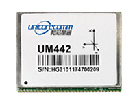
The UM442 can simultaneously track GPS, BDS, GLONASS and Galileo. It also supports SBAS and QZSS. It uses Uncore’s new-generation Nebulas II chip and UGypsophila real-time kinematic (RTK) algorithm. Based on high-performance data-sharing technology and the simplified operation system of the Nebulas II chip, the UGypsophila RTK algorithm dramatically optimizes matrix processing, enabling the UM442 to track more satellites and shorten the initialization time to 5 seconds.
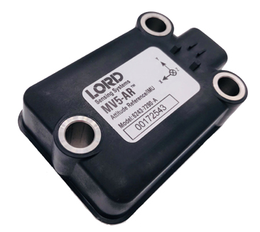
The MV5-AR inertial sensors are designed for off-highway and military vehicles, marine and mobile robot applications, and the autonomous vehicle market. The rugged, compact sensors use LORD’s fifth-generation high-performance industrial-grade solid-state six-degrees-of-freedom (6-DOF) micro-electromechanical accelerometer and gyro inertial sensor technology. Successfully deployed on ground robots and heavy machinery, applications also include autosteer and terrain compensation; dynamic incline detection (roll, pitch, rotation); vehicle stability and leveling; platform control, alignment and stabilization; operator feedback; and precision navigation. The compact and rugged reinforced housing is fully sealed for immersion and pressure wash. Each sensor is calibrated and temperature compensated.
BeiDou Phase 3 signals are now available on Spirent GNSS RF constellation simulators GSS7000 and GSS9000 — existing users can obtain the software upgrade by contacting Spirent. Phase 3 of the Chinese BeiDou system will extend its coverage from Asia to the entire world, providing receiver developers and integrators with additional GNSS signals to make positioning, navigation and timing systems more accurate, and help to support new applications, such as autonomous vehicles. Customers can test their designs before the system is fully operational in 2020.
The ZED-F9P multi-band GNSS module has integrated multi-band real-time kinematic (RTK) technology for machine control, ground robotic vehicles and high-precision unmanned aerial vehicles applications. It measures 22 x 17 x 2.4 millimeters and uses technology from the u‑blox F9 platform to deliver robust high-precision positioning performance in seconds. The ZED-F9P is a mass-market multi-band receiver that concurrently uses GNSS signals from all four GNSS constellations (GPS, GLONASS, Galileo and BeiDou). Combining GNSS signals from multiple frequency bands (L1/L2/L5) and RTK technology lets the ZED‑F9P achieve centimeter-level accuracy in seconds.
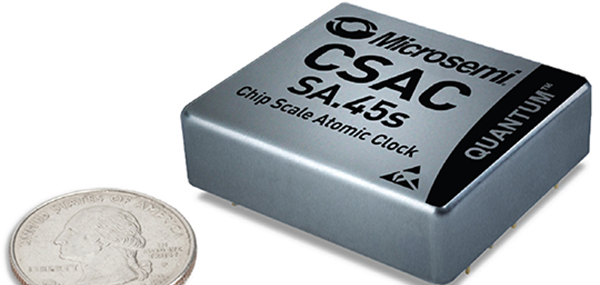
The SA.45s Commercial Space Chip-Scale Atomic Clock (CSAC) is a commercially available radiation-tolerant CSAC suitable for low Earth orbit (LEO) applications. The device provides the accuracy and stability of atomic clock technology while achieving significant breakthroughs in reduced size, weight and power consumption. It provides excellent drift performance and built-in 1 pulse per second (PPS) input for GPS disciplining, making the device well-suited for holdover applications. Commercial and research space applications include satellite timing and frequency control; satellite cross linking; assured position, navigation and timing; and Earth observation.
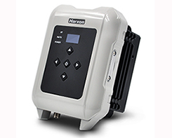
The long-range, power-efficient eRadio is designed to support high-precision GNSS real-time kinematic (RTK) applications in surveying and precision agriculture. It is enabled with intelligent serial baud rate identification for different RTK devices. It can automatically identify RTK serial baud rate with a radio data cable and provide a plug-and-play form for easy connection between the eRadio and RTK. With its high transmitting power (5-35 Watts), transmission data can be up to 19200 bps/s over a connection distance of 50–80 kilometers. It can work as either a base or repeater with other Harxon radio modems in challenging environments.
Wireless communication with any Android or Windows terminal
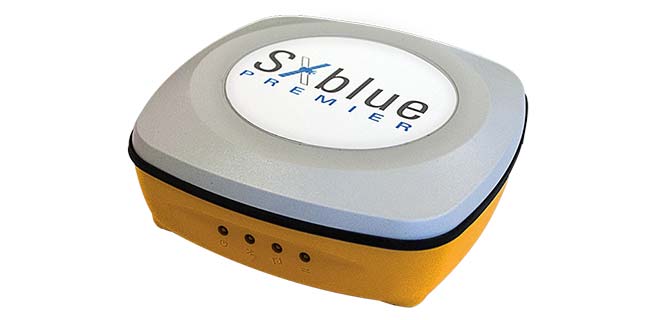
Image: SXblue/Geneq
The SXblue Premier GNSS receiver is available in a submetric version (GNSS) or centimetric version (RTK). It is equipped with Pacific Crest Maxwell 6 Trimble technology with BD910 (GNSS version) and BD930 (RTK version) OEM boards, delivering 220 channels to acquire and track GNSS signals from all constellations in view. It makes effective use of GPS, GLONASS, Galileo, BeiDou, QZSS and SBAS signals for precise positioning.
The single-frequency, multi-GNSS Vector V123 and V133 all-in-one smart antennas are multi-GNSS compass systems using GPS, GLONASS, BeiDou, Galileo and QZSS for simultaneous tracking for heading, position, heave, pitch and roll. Both support NMEA 0183 and NMEA 2000. The V123 and V133 thrive in radar/ARPA, AIS, ECDIS, side-scan survey, multi- and single-beam surveys, dredging and general navigation applications.
The Trak4 provides GPS tracking with cell-trilateration fallback. Ping rates can be selected from every two minutes to once a day, with email and text alerts provided for geozone entry and exit or if the high-capacity rechargable battery is low (the battery runs up to 12 months on a single charge.) The Trak4 is designed for tracking vehicles, assets and inventory; it can also be used to track people such as the elderly. Indoor/outdoor weatherproofing allows “anywhere” mounting.
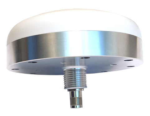
PCTEL’s multi-GNSS L1/L2/L5 antennas combine aerospace-level precision with global satellite compatibility in a highly durable package. They enable critical applications including vehicular automation, 5G network timing synchronization and Positive Train Control (PTC) systems. The antennas increase the accuracy of timing and location information by providing simultaneous access to multiple GNSS signals across multiple frequency bands. The antennas support all relevant GPS, GLONASS, BeiDou and Galileo frequencies with excellent multipath mitigation and high out-of-band rejection for greater signal clarity. Their robust AAR and IP67-compliant design makes them suitable for years of use on railways and in other harsh real-world environments.
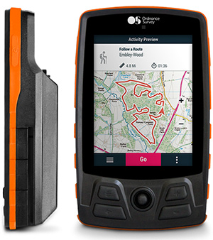
Four new GPS handhelds are designed for off-road use, with safety in mind. All four of the OS GPS models have a built-in SIM card with access to the SeeMe subscription-based service and its safety features. With I.C.E (In Case of Emergency), users can send emergency alerts with exact coordinates to family and friends directly from the OS GPS. Live Tracking enables the user to be locatable at all times, sharing location and performance data with up to 20 friends in real time. Aventura, the most advanced navigation device, can be used in all weather conditions.
Zubie Fleet Connect provides real-time GPS fleet tracking, driver check-in and performance reports, and vehicle health alerts. The monitoring and reporting service lets managers of fleets from 2 to 5,000 vehicles optimize business on the road. Wi-Fi connection to the cloud delivers important information about the health and performance of the vehicle, enhancing driver safety. Zubie also works with large enterprises to develop custom data flows and access driving data that can be used to analyze driving patterns, spot geographical trends in activity, or improve fleet asset management based on vehicle wear and tear.
The Heliscope 2.0 provides onboard data collection with speed, efficiency and productivity improvements for the utility inspection industry. It provides a solution for operations over greater distances or in harsher environments than drones can accommodate The system integrates multiple sensor systems into a single, lightweight helicopter payload, capable of simultaneously collecting a range of data types required for utility maintenance and vegetation management inspections. Deployment enables optimized inspection and maintenance schedules, offering potential cost savings in those operational activities by as much as 50 percent. The Heliscope 2.0 has flexible mounting configurations and the ability to adapt for mounting on many different helicopter types.
Based on DJI’s M600 Pro platform, the Leica Aibot system is designed to rapidly and autonomously enable digitizing of critical infrastructure. It enables users to get a complete data set quickly with a user-friendly interface. Using Leica Infinity for point-cloud, digital surface model and orthophoto generation enables surveyors to process and visualize aerial data. For construction projects, Aibot provides access to critical information to perform volume calculations and monitor site progress. Users can see high-definition imagery and 3D mapping of the site and document progress. The UAV data can be combined with other survey technologies such as GPS for a more complete set of information.
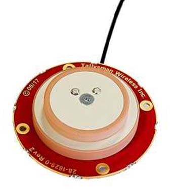
Two lightweight, compact antennas are designed for UAVs with a low aerodynamic profile. Antenna model TW1829 is for original equipment manufacturers (OEMs), and model TW8829 is a housed version. Accutenna technology provides high-level rejection of multipath signals, a phase linear response and tight phase-center variations. Pre-filters prevent saturation of the front-end low noise amplifier by strong near frequency and harmonic signals.
The HA32 high-performance antenna supports GPS, GLONASS, Galileo, BeiDou and Hemisphere’s Atlas L-band correction service. It is designed for UAVs, geographic information systems (GIS), surveying, real-time kinematic (RTK) and other applications requiring high-precision positioning and navigation. The HA32 is built on a proprietary four-helix antenna technology that provides superior filtering and anti-jamming performance with features such as a low noise figure of 2.0 dB (typical) and up to 30-dB gain (typical). Suitable for most outdoor and harsh operating environments, the HA32 antenna is sealed in a durable and ruggedized IP67-rated. The lightweight (40 g, typical), compact form factor (40 x 75 mm) makes it resistant to wind when on UAVs.