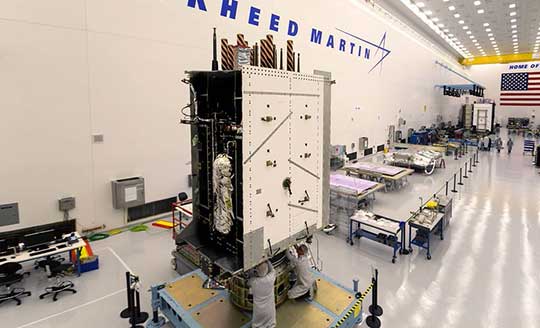
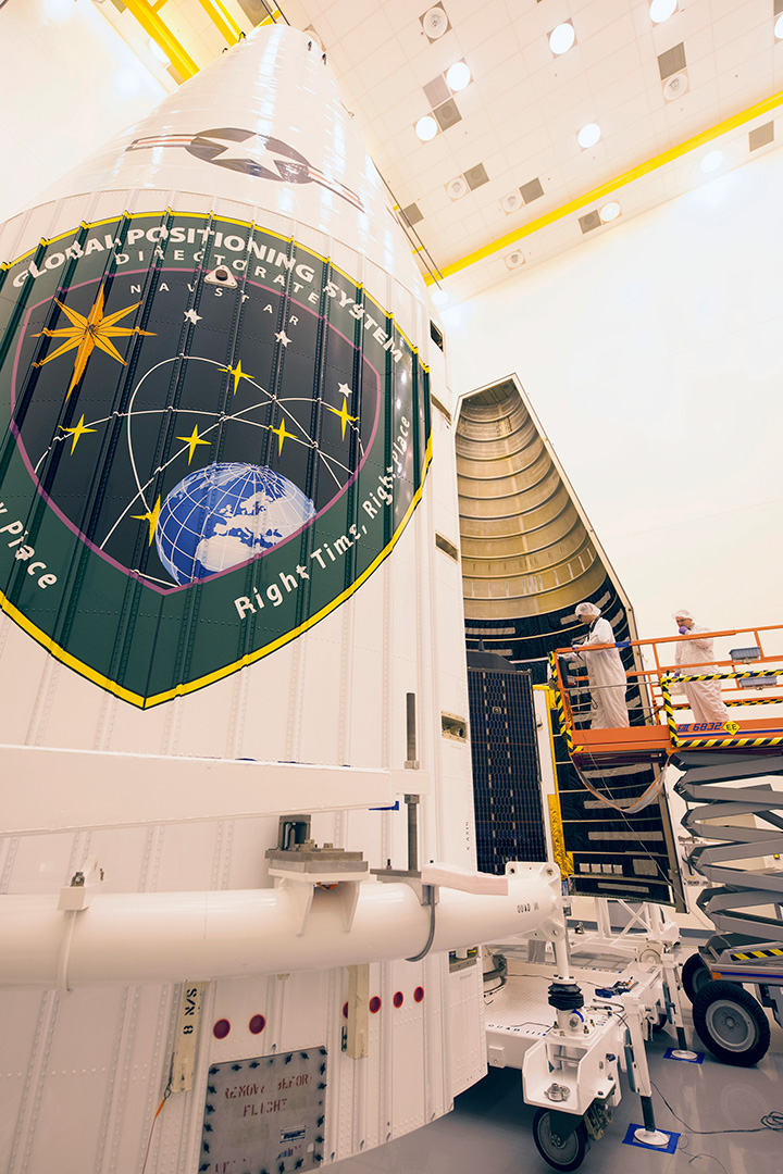
The nation’s third next-generation GPS III satellite — and the first delivered by Lockheed Martin to the new U.S. Space Force — has arrived in Florida for an expected April launch.
On Feb. 5, the third Lockheed Martin-built GPS III space vehicle (GPS III SV03) was shipped to Cape Canaveral from the company’s GPS III Processing Facility near Denver aboard a massive Air Force C-17 aircraft traveling from Buckley Air Force Base, Colorado.
GPS III SV03 — nicknamed “Columbus” — is the latest of up to 32 next-generation GPS III/GPS III Follow-On (GPS IIIF) satellites Lockheed Martin has designed and is building to help the Space Force modernize GPS with new technology and capabilities.
On Jan. 13, 2020, GPS III SV01 (“Vespucci”) was set healthy and active by the 2nd Space Operations Squadron (2 SOPS) at Schriever Air Force Base, in Colorado. 2 SOPS is now using the GPS III Contingency Operations (COps)-upgraded OCS ground control system to operate both the new GPS III and previously launched GPS satellites.
GPS III SV02 (“Magellan”), launched on Aug. 22, 2019, has completed its on-orbit testing and is currently awaiting its turn for integration into the constellation.
On Jan. 21, 2020, the Space Force called up GPS III SV04 for a launch later this summer. GPS III SV05-09 are now in various stages of assembly and test at Lockheed Martin’s commercial-like large satellite production line for GPS III satellites near Denver.
The company is expected to soon complete its critical design review with the Space Force to begin production on the first two GPS IIIF satellites under contract.
GPS III Advantages
GPS III is the most powerful and resilient GPS satellite ever put on orbit. Developed with an entirely new design for U.S. and allied forces, GPS III has three times greater accuracy and up to eight times improved anti-jamming capabilities over any previous GPS satellites in the constellation.
GPS III is also the first GPS satellite to broadcast the new L1C civil signal, which is shared by other international global navigation satellite systems, like Galileo, to improve future connectivity worldwide for commercial and civilian users.
“Every day, more than four billion civil, commercial and military users rely on the positioning, navigation and timing (PNT) services provided by 31 GPS satellites launched since 1997,” said Tonya Ladwig, Lockheed Martin’s program manager for GPS III. “We are excited to help the Space Force refresh the constellation to ensure U.S. and allied forces always have the best technology and that the U.S. Global Positioning System remains the gold standard for PNT.”
GPS III was designed to evolve with new technology and changing mission needs. The satellite’s evolutionary modular design will allow new GPS IIIF capabilities to start being added at the 11th satellite. These will include a fully digital navigation payload, a Regional Military Protection capability, an accuracy-enhancing Laser Retroreflector Array, and a Search & Rescue payload.
”It’s an exciting time across the GPS mission as we bring together the best of our space, ground, and operations systems to help the United States Space Force modernize this critical national capability,” commented Johnathon Caldwell, Lockheed Martin’s vice president for Navigation Systems.
Lockheed Martin’s GPS III team is led by the Production Corps, Medium Earth Orbit Division, at the Space Force’s Space and Missile Systems Center, Los Angeles Air Force Base.
2 SOPS, at Schriever Air Force Base, manages and operates the GPS constellation for both civil and military users.
Lockheed Martin shipped the U.S. Space Force’s third GPS III satellite to Cape Canaveral, Florida, ahead of its expected April launch. (Photo: Lockheed Martin)
By Staff Sgt. Matthew Coleman-Foster, 50th Space Wing Public Affairs
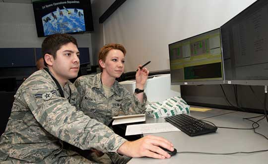
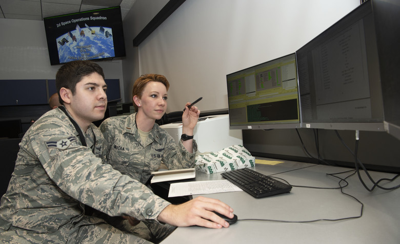
The 2nd Space Operations Squadron set Satellite Vehicle Number-74 (SVN-74, the first GPS III satellite) as healthy and active to users on the 2nd SOPS operations floor.
Setting SVN-74 healthy and active means the satellite will be available for use by military and civilian GPS users around the world as part of the constellation currently maintained by the squadron. This makes the satellite the first iteration in the GPS III family to join the active constellation following its launch Dec. 23, 2018.
Capt. Ryan Thompson, 2nd SOPS assistant director of sustainment, said various training modules and upgrades were instrumental in making the satellite operational.
“In order to operate GPS III, we first had to install Architecture Evolution Plan 8.0,” he said. “This allowed our squadron to control the new satellite without a next generation operational control system. The 2nd SOPS training and evaluations flight was able to expeditiously give our operators top-up training that allowed them to become comfortable with the new satellite.”
The GPS III vehicle family provides new capabilities vital to ensuring the fidelity of the constellation and signal in the contested, degraded and operationally limited environments.
According to the Lockheed Martin press release, GPS III satellites have three times better accuracy and up to eight times improved anti-jamming capabilities than their predecessors, and a design life extending 25 percent longer than the newest GPS satellites on-orbit today. GPS III’s new civil signal will also make it the first GPS satellite to broadcast a compatible signal with other international global navigation satellite systems, like Galileo, improving connectivity for civilian users.
2nd SOPS is already preparing for the second GPS Block III vehicle in orbit, awaiting its day to become healthy and active.
“There are vehicles currently projected to be put into the constellation and then following this there will be the Block III-F follow-on vehicles,” said Capt. Kaoru Elliot, 2nd SOPS assistant director of operations. “With those vehicles in place, all of those capabilities will come into the next decade.”
A third vehicle for GPS III is scheduled for launch later this year.
“It [GPS Block III vehicle two] is being managed currently by Lockheed Martin,” Elliott said. “They are the ones actually getting the satellites up there and once it is up in orbit, they make sure everything is good before handing it over to us.”
The work within 2nd SOPS to ensure SVN-74 is healthy and active in the constellation shows their commitment to continue providing the gold standard of position, navigation, and timing to 4 billion users around the world.
Second Lt. Kelley McCaa, 2nd Space Operations Squadron satellite vehicle operator, and Airman 1st Class John Garcia, 2nd SOPS satellite systems operator, set satellite vehicle number-74, the first iteration of GPS Block III vehicles, as healthy and active to users Jan. 13, 2020, Schriever Air Force Base, Colorado,. Setting the vehicle healthy and active makes the satellite available for use by military and civilian GPS users around the world for agriculture, banking and navigation. (Photo: U.S. Air Force/Staff Sgt. Matthew Coleman-Foster)
The U.S. Air Force Second Space Operations Squadron (2 SOPS) has issued a statement that the first GPS III satellite is available for backup. While occupying the same plane as SV-68, the new satellite is broadcasting healthy, usable signals and is an active part of the constellation in the vicinity of slot F3 near SV-68.
On. Jan. 13, 2 SOPS issued an Initial Use (USABINIT) NANU for SVN-74, the first of the new generation of GPS-III satellites, according to Rick Hamilton, CGSIC executive secretariat.
SVN-74/PRN-04 was launched on Dec. 23, 2018. Now, having successfully undergone rigorous operational testing on orbit, the satellite has taken its place, backing up SVN-68/PRN-9 at F3 in the active GPS constellation.
NOTICE ADVISORY TO NAVSTAR USERS (NANU) 2020004
SUBJ: SVN74 (PRN04) USABLE JDAY 013/1734
NANU TYPE: USABINIT
NANU NUMBER: 2020004
NANU DTG: 131735Z JAN 2020
REFERENCE NANU: N/A
REF NANU DTG: N/A
SVN: 74
PRN: 04
START JDAY: 013
START TIME ZULU: 1734
START CALENDAR DATE: 13 JAN 2020
STOP JDAY: N/A
STOP TIME ZULU: N/A
STOP CALENDAR DATE: N/A
CONDITION: GPS SATELLITE SVN74 (PRN04) WAS USABLE AS OF JDAY 013
(13 JAN 2020) BEGINNING 1734 ZULU.
POC: CIVILIAN – NAVCEN AT 703-313-5900, HTTPS://WWW.NAVCEN.USCG.GOV
MILITARY – GPS OPERATIONS CENTER at HTTPS://GPS.AFSPC.AF.MIL/GPSOC, DSN 560-2541,
Capt. Adam Moody, 2 SOPS GPS Operations Support flight commander, and Staff Sgt. Carl Ellinger, 2 SOPS GPS mission chief, review a checklist of procedures for a transfer operation at Schriever Air Force Base. (Photo: U.S. Air Force photo/Dennis Rogers)
The 2nd Space Operations Squadron (2 SOPS), based at Schriever Air Force Base, will implement the GPS Issue of Data, Clock software modification this summer in accordance with established guidance, according to Rick Hamilton, CGSIC Executive Secretariat, U.S. Coast Guard Navigation Center.
The modification is in compliance with GPS Interface Specifications IS-GPS-200, which is published for manufacturers to ensure continued device compatibility.
As the largest Department of Defense spacecraft constellation, operators must modify processes, software and operations to meet the ever-growing demand for GPS signals. The squadron conducts software modifications regularly to support the constellation.
The modifications are primarily transparent to users, specifically those with IS-GPS-200 compliant devices. Users who experience issues with their devices or receivers should contact the manufacturer to troubleshoot the problem.
The U.S. Coast Guard Navigation Center provides information and services to civil GPS users. They can be contacted at 703-313-5900 or online.
On Jan. 26 at 12:49 a.m. MST, the 2nd Space Operations Squadron (2 SOPS) at the 50th Space Wing, Schriever Air Force Base, Colo., verified users were experiencing GPS timing issues. Further investigation revealed an issue in the GPS ground software that only affected the time on legacy L-band signals. This change occurred when the oldest vehicle, SVN 23, was removed from the constellation.
While the core navigation systems were working normally, the coordinated universal time timing signal was off by 13 microseconds, which exceeded the design specifications. The issue was resolved at 6:10 a.m. MST; however, global users may have experienced GPS timing issues for several hours.
U.S. Strategic Command’s Commercial Integration Cell, operating out of the Joint Space Operations Center, effectively served as the portal to determine the scope of commercial user impacts. Additionally, the Joint Space Operations Center at Vandenberg AFB has not received any reports of issues with GPS-aided munitions, and has determined that the timing error is not attributable to any type of outside interference such as jamming or spoofing.
Operator procedures were modified to preclude a repeat of this issue until the ground system software is corrected, and the 50th Space Wing will conduct an Operational Review Board to review procedures and impacts on users. Commercial and Civil users who experienced impacts can contact the U.S. Coast Guard Navigation Center at (703) 313-5900.
By 50th Space Wing Public Affairs, Schriever Air Force Base
Throughout the years, GPS has achieved historic milestones and garnered recognition for its contributions to the betterment of humanity.
2015 was no different.
Photo: 50th Space Wing Public Affairs, Schriever Air Force Base
GPS, operated by the dedicated men and women of the 2nd and 19th Space Operations Squadrons at Schriever Air Force Base, Colorado, is also the world’s largest military satellite constellation. Uses of GPS include precise timing for financial transactions, search and rescue, communications, farming, recreation and both military and commercial aviation.
The 2 and 19 SOPS, referred to as Team Black Jack, hosted GPS Week Feb. 15-20 to honor their heritage and interact directly with the Colorado Springs community. The week included a community geo-caching event, GPS/base tours for dozens of middle and high school students, 2 SOPS educational outreach events at local schools and culminated with a GPS heritage celebration.
“We wanted to touch the different facets of our community and that’s why we planned these events,” said Tech. Sgt. Abifarin Scott, 2 SOPS GPS maintenance flight chief.
GPS received historic recognition from the city of Colorado Springs a few months later.
Colorado Springs City Council members presented a proclamation declaring July 17, 2015, GPS Day during a ceremony July 15.
“It’s a great time, a significant milestone that [GPS] has been active this long,” said Andy Pico, Colorado Springs City Council member. “GPS has grown to be such a tremendous part of everybody’s lives, it runs everything…it’s so much into the fabric of everybody’s life.”
The proclamation came as the Air Force celebrated GPS’s 20 years of full operational capability, confirmed July 17, 1995. During the last 20 years, GPS has become an integral part of technology that affects the lives of billions of people around the world.
The men and women of GPS stayed busy supporting many operations throughout the year.
GPS IIF-10. (Photo: ULA)
The Air Force and the 45th Space Wing supported the successful launch of a United Launch Alliance Delta IV rocket that roared to life March 25, carrying the Air Force’s ninth Block IIF-09 navigation satellite for the GPS.
2 and 19 SOPS accepted satellite control authority of GPS IIF-9 Satellite Vehicle Number-71 April 3.
2 SOPS successfully completed a transfer operation of GPS satellite control authority to the Alternate Master Control Site at a backup location on June 6.
2 and 19 SOPS accepted command and control of the 10th GPS Block IIF satellite July 24.
After 15 years of launch operations for the GPS, 19 SOPS completed their 26th launch as a squadron Oct. 31, performing checkout operations on the 11th GPS IIF satellite.
On Nov. 6, Team Black Jack accepted SCA just six days after the Halloween launch of satellite vehicle number-73 – in record time. Members of Team Black Jack prepped for the launch and subsequent SCA acceptance of SVN-73 for approximately three months.
The Command’s GPS operations were showcased in multiple venues this year, engaging with communities and making the mission known all over the world.
CBS featured the 50th Space Wing and GPS on an episode of 60 Minutes, and BLUE, the Air Force’s flagship TV show, also featured GPS — both of which displayed the capabilities it offers to humanity.
Beyond its essential capability for the military, GPS is a worldwide utility that provides the highest accuracy data available to people all around the world and enables such vital activities as weather forecasting, transportation, global commerce and farming/agriculture.
“2 SOPS’s continuing objective is to ensure GPS remains the gold standard for global space-based navigation and timing by providing highly reliable and accurate GPS signals to users around the world,” said Lt. Col. Todd Benson, 2 SOPS Commander. “We look forward to continuing to provide our mission partners and global users with the most accurate position, navigation and timing signal available in the history of GPS.”
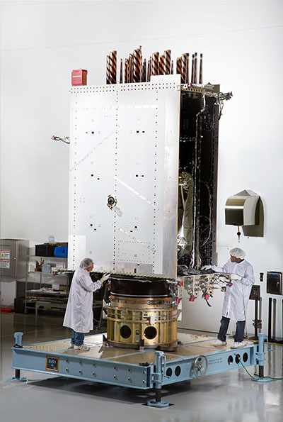
First Photo a GPS III Satellite: In April, Lockheed Martin fully integrated the U.S. Air Force’s first next-generation GPS III satellite. GPS III Space Vehicle One is now preparing for system-level testing this summer.
Using a 10-ton crane, Lockheed Martin engineers and technicians gently lowered the system module of the U.S. Air Force’s first next generation GPS III satellite into place over its propulsion core, successfully integrating the two into one space vehicle.
The April systems integration event brought together several major fully functional satellite components. The system module includes the navigation payload, which performs the primary positioning, navigation and timing mission. The functional bus contains sophisticated electronics that manage all satellite operations. The propulsion core allows the satellite to maneuver for operations on orbit.
“The final integration of the first GPS III satellite is a major milestone for the GPS III program,” said Mark Stewart, vice president of Lockheed Martin’s Navigation Systems mission area. “This summer, SV 01 will begin Thermal Vacuum testing, where it will be subjected to simulated harsh space environments. Successful completion of this testing is critical as it will help validate our design and manufacturing processes for all follow-on GPS III satellites.”
Lockheed Martin is under contract to build eight GPS III satellites at its GPS III Processing Facility near Denver, a factory specifically designed to streamline satellite production.
GPS III space vehicle one (SV 01) is the first of a new, advanced GPS satellite design block for the Air Force. GPS III will deliver three times better accuracy, provide up to eight times improved anti-jamming capabilities, and extend spacecraft life to 15 years — 25 percent longer than the satellites launching today. GPS III’s new L1C civil signal also will make it the first GPS satellite interoperable with other international global navigation satellite systems.
As I write this, the 31st Space Symposium (SS) will kickoff in just 5 days, on April 13 at the incomparable Broadmoor Resort in Colorado Springs, Colo., at the foothills of the beautiful Rocky Mountains.
Neil deGrasse Tyson (courtesy of PBS)
If you haven’t figured it out already, the 31st SS is not a WWII German unit designation, but the 31st Space Symposium, which Dr. Neil deGrasse Tyson, famed astrophysicist, bestselling author, director of the Hayden Planetarium and host of the hugely successful television series Cosmos: A Spacetime Odyssey, simply calls “the most awesome symposium in the world.” Very high praise indeed, and a sentiment with which I totally agree.
Breaking Records
This year’s Space Symposium, which is sponsored by the Space Foundation, will be the largest ever held in terms of venue, size (number of exhibitors and speakers) and attendance. Approximately 10,000 space enthusiasts are expected to attend, and I hope you are one of them. My sources tell me the classified sessions (Cyber 1.5 and classified space sessions) are filled to overflowing — no new registrations allowed there. The exhibitor space at the Ball Aerospace Exhibit Center and Pavilion is bursting at the seams. The organizers are turning exhibitors away, so better luck next year. But if you just want to attend the greatest space symposium in the world, bar none, there is still time to register.
By the way, if you haven’t figured it out already, this is a truly international event. My sources at the Space Foundation stated that the 31st Space Symposium will have more international participation than ever, including more than 150 exhibits of the world’s latest space technology, products and services. The Ball Aerospace Exhibit Center will host more than 30 first-time exhibitors with more than a dozen countries represented, including: Austria, Canada, Denmark, France, Germany, Japan, New Zealand, Norway, Scotland, Sweden, Turkey, the UK and the U.S. The symposium is expected to attract space leaders from more than 25 countries, representing all sectors of the global space community.
Everyone who is anyone in the space world will probably be there or be represented. Consequently, the networking capabilities are unparalleled. Not to mention just being able to avail yourself of the world-famous Broadmoor Resort hospitality, plus the crisp, clean and cool mountain air at 6,000 feet.
Event Preparation
For many years, the event was known as the National Space Symposium. It outgrew that moniker many years ago, and is now simply known as the Space Symposium.
Every year before I attend the Space Symposium, I make a “ToDoToDay” list of topics I want to explore, both as a journalist and in my senior space analyst profession. Plus, of course, I make a list of people I definitely want to talk with or interview. This year, I thought I would share some of those to-dos with you, because you may indeed have some of the same interests.
GPS III
Mark Stewart, Lockheed Martin GPS III program manager (courtesy of Lockheed Martin)
Wearing my subject matter expert (SME) hat, so to speak, I recently had the honor of touring the Lockheed Martin (LMCO) Space Systems facility in Waterton Canyon (far West Denver), Colorado, where the GPS III satellites are built, integrated and otherwise readied for launch. I took the opportunity to chat with Mark Stewart and his crew. Mark is vice president for manufacturing and space systems and program manager for GPS III.
I learned that the first GPS III space vehicles (SVs) is much farther along than most everyone thinks. The problematic MDU (Mission Data Unit — the heart of the system) from Exelis has been fully tested and integrated into the payload. GPS III SV1 was only three days from being totally integrated or mated, as they say, with the on-orbit propulsion portion of the payload (the remainder of the LMCO A2100 bus) and beginning its months-long testing, certification and verification process. According to Mark, GPS III SV-01 — which powered on initially in February 2013 — now is in integration and test flow leading up to final delivery to the Air Force.
While it was thrilling to see everything finally coming together, I will also tell you candidly that the next milestone everyone is asking about, the first GPS III launch date, is probably as fluid as the Snake River in Spring. So, while I do not feel comfortable quoting a first launch date, and LMCO would not give me a firm date for delivery of the first GPS III SV, I do feel comfortable making this prediction: Barring any unforeseen major issues during testing, LMCO will be ready to deliver to the U.S. government the first ready-to-launch GPS III satellite by the end of this calendar year. That’s right, in my humble opinion the first GPS III SV will be ready to deliver to the Air Force by December 2015. When it will actually be launched is anybody’s guess; obviously, the sooner the better. Apropos of the Boeing IIF initial launches and critical on-orbit anomalies, the sooner the LMCO GPS III is put into orbit for full-scale operational and mission analysis tests the better.
LADO and OCX
The critical question of course is: Will the U.S. Air Force (USAF) have a ground control system that can successfully and reliably launch and support a full-up GPS III SV by the end of 2015? Certainly not if they stay the course with OCX, but there are alternatives, and you know who you are! Can you say LADO, Launch/Early Orbit, Anomaly Resolution, Disposal and Operations System?
Consider that LADO has been utilized to launch GPS satellites as far back as the GPS IIR-M family of satellites, also produced by LMCO, one of which was successfully launched on October 17, 2007, using the then-new LADO system. That milestone ensured the GPS program continued to provide superior space-based navigation for billions of users, military, civilian and commercial, around the globe using industry-leading highly modified (Aces Premier) commercial launch technology. This significant achievement was the culmination of outstanding teamwork between the USAF, Braxton Technologies, the engineering firm and the prime contractor.
The LADO system formed and is still the backbone of the new GPS Command and Control (C2) functionality implemented by the prime contractor. It known today as the Advanced Architecture Evolution Plan (AEP). Subsequently, LADO is now the primary launch system for all current and future (IIR-M, IIF and possibly GPS III) satellites, which should allow the U.S. Air Force to retire some outdated legacy GPS ground support and command and control systems.
The first successful 2007 LADO launch and control of an operational GPS IIR-M satellite, and the 1SOPS and 2SOPS operators’ acceptance of the GPS LADO system, was proof that commercial software can be deployed effectively even in a militarily critical mission system, saving the government both cost and schedule without sacrificing mission-unique capabilities.
In my humble opinion, that is where we need to go today. Let’s return to the tried-and-true LADO and prime contractor partnership and launch the first GPS III SV by the end of this year, or certainly by early 2016. Please notice I have not made any statements concerning scrapping the hugely expensive, 100-percent-over-budget-and-schedule (years behind) OCX program of record. Under Secretary of Defense for Acquisition, Technology and Logistics (USDATL) Frank Kendall recently announced the controversial decision that OCX as the program of record would go forward under strict scrutiny with definite milestones that must be met. Scrutiny is a fickle mistress, and historically on the OCX program, milestones are there to be missed. Meanwhile, the USAF requires a tried, proven and utterly reliable capability to launch GPS III SVs as soon as the first few become available. The USAF must place several GPS IIIs on orbit for a full checkout to ensure there are no major anomalies. Currently, LADO had an eight-year proven track record with no failures, and it remains the only program that can initiate, control and dispose of residual GPS satellites — including the IIAs, which are the longest lived GPS satellites on orbit today.
Beware, there will be many naysayers in government circles, and you may meet some of them at the symposium, that will tell you it is just not possible. But just stop by and talk candidly with LMCO Space Systems and Braxton Technologies personnel, and see what they have to say. You may be surprised by what you hear.
Then stop by the Raytheon booth and check on the status of OCX.
Lynn Dugle (courtesy of Raytheon)
Female Executives in the News
Speaking of OCX and Raytheon, Lynn Dugle retired from Raytheon on March 2, 2015. Historically, Lynn has been a very capable executive. She is the former president of Raytheon’s Intelligence, Information and Services (IIS) business, which handles several key U.S. Air Force space contracts, including OCX, the current program of record for the next-generation ground system for GPS III. Dugle served as president of the division beginning in 2009.
David Wajsgras (your guess is as good as mine), Raytheon’s former senior vice president (SVP) and chief financial officer (CFO), has replaced Dugle. Wajsgras served as SVP and CFO of Raytheon Company from March 2006 to March 2015.
David Wajsgras (courtesy of Raytheon)
As a member of Raytheon’s senior leadership team, he directed Raytheon’s overall financial strategy. In my humble opinion, he has his work cut out for him. He will need all of his financial expertise and acumen to make OCX a success — financially and, hopefully, operationally. The program is grossly over budget, several years behind schedule, and reportedly, my sources tell me, far less capable than originally planned. Good luck, David.
As long as we are still speaking primarily of female executives with great track records, USAF Lieutenant General Ellen Pawlikowski, who I have had the honor of knowing and working with for the past 25 years, was recently nominated for her fourth star. General Pawlikowski successfully commanded the SMC (Space and Missile Systems Center) and served as Program Executive Officer (PEO) for Space for three years at Los Angeles Air Force Base in California. Among her many successful space acquisition programs, she was responsible for GPS procurement during her tenure.
Lt. Gen. Ellen Pawlikowski, USAF (courtesy of the USAF)
Currently, General Pawlikowski serves on the East Coast in the Pentagon as the military deputy to William LaPlante, Ph.D., the assistant secretary of the Air Force for acquisition. In other words, LaPlante is the Air Force’s Service Acquisition Executive, responsible for all Air Force research, development and acquisition activities. Previously, just to add to her mystique, General Pawlikowski spent more than one tour at the super secret National Reconnaissance Office.
When confirmed, General Pawlikowski will be only the third female four-star general in U.S. Air Force history. A well-deserved honor and one that certainly merits acknowledgement. General Pawlikowski is scheduled to speak several times at the Space Symposium, so when you see her, congratulate her on a job well done and on being nominated for her fourth star, and wish her luck in her new assignment as the head (four-star commander) of Air Force Materiel Command.
Before we leave the female leader category, my sources tell me that USAF Colonel DeAnna Burt, commander of the 2nd Space Operations Squadron (2 SOPS, the GPS squadron) from 2008 to 2010, will in June 2015 become only the third female commander of the 50th Space Wing at Schriever AFB, Colorado — home to 2 SOPS. She follows in the very capable footsteps of then-Colonel Suzanne (Zan) Vautrinot, who was the first female wing commander at the50th Space Wing followed by then-Colonel Teresa (Terry) Djuric. Note that both Suzanne and Terry, who are now retired from active duty, went on to become general officers in the USAF.
Commander AFSPC – Gen. John Hyten (courtesy of the USAF)
Currently, Colonel Burt serves as director of the Air Force Space Command (AFSPC) Commander’s Action Group for General John Hyten. General Hyten, the current commander of AFSPC, is himself a former 50th Space Wing commander, and he will also be speaking several times at the space symposium. Here’s a big hint: As a four-star general, General Hyten has morphed into quite a forceful, informative, entertaining and engaging speaker. You won’t want to miss any of his presentations.
If you see Colonel Burt at the Space Symposium, please congratulate her on her new assignment, and you might offer her your prayers for the incredible amount of responsibility she is about to assume. I’m betting she can handle it.
GPS Directorate
Another USAF general officer you are sure to run into at the Space Symposium is a newly minted brigadier general known by some as Wild Bill Cooley. General Cooley, who is currently the director of the GPS Directorate at SMC, was pinned on just a few weeks ago and will be speaking several times at the symposium. Wild Bill also deserves your congratulations. By all accounts, he is doing a great job and has more stars in his future.
The Place to Be
So, while there are several points to be made, a key one appears to be that if you are heavily involved with the GPS program inside and outside the USAF and you do a good job, it can work wonders for your career. If you want to hear from those who have been successful, the 31st Space Symposium is the place to be.
I hope to see you at the Broadmoor April 13-16. Come early and wear your walking shoes. Please stop by the GPS World booth and say hello to everyone. I will be there for sure.
As I wind up this to-do list, I will tell you about another Space Symposium event where it is important, even critical, to be seen. Everyone who is anyone will be attending the Connecting Colorado private function on Wednesday evening, April 15. The event is hosted by the Braxton Science and Technology Group; this is the third year for the coveted event. As I have stated before, I have attended 26 of the 31 Space Symposiums, and I have never been to an after-hours function during that time that even approaches the quality and class that Connecting Colorado exudes. It is a first-class event in a visually stunning venue, where private access passes are required to enter and guards are serious about keeping out gatecrashers. If history is any guide, it promises to be an amazing evening of fine wines, sumptuous food, quality cigars, roaring fireplaces and professional camaraderie that can’t be beat. Plus, the networking opportunities are endless. In other words, the Connecting Colorado event is what all the other after-hours Space Symposium events long to be or wish they could emulate. I can’t wait. I hope to see you there, and at the 31st Space Symposium. By the way, April in the Rocky Mountains means dress appropriately — warmly works for me.
Until next time, Happy Navigating, and remember: GPS is brought to you courtesy of the United States Air Force.
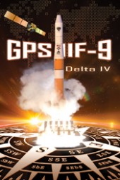
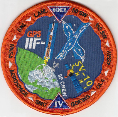
A patch for the upcoming GPS satellite launch shows a stylized GPS IIF-IX formed by the Delta 4 rocket and the constellation Cygnus (Latinized Greek word for swan). The satellite is nicknamed Deneb, the brightest star in the constellation and one of the 57 stars used in celestial navigation. The patch also indicates that the satellite is SV-10 and 71. The SV-10 identifier may indicate that it is the 10th satellite off the IIF assembly line. Photo: US Air Force
The U.S. Air Force’s ninth GPS Block IIF satellite (GPS IIF-9) is set to launch Wednesday at 2:36 p.m. EDT (1836 GMT) from Space Launch Complex 37 at Cape Canaveral Air Force Station, Fla.
The GPS IIF-9 will ride aboard a United Launch Alliance (ULA) Delta IV rocket, marking the 29th Delta IV launch and the 57th operational GPS satellite to launch on a ULA or heritage launch vehicle.
GPS IIF-9 is one of the next-generation GPS satellites, incorporating various improvements to provide greater accuracy, increased signals, and enhanced performance for users.
UPDATE (April 17, 2015): The USCG Navigation Center has confirmed that SV-10 was launched instead of SV-9. The Air Force discovered a problem with SV-9, so it was pulled from the launch and SV-10 was sent into orbit in its place. SV-9 will be used in a future launch.
Constellation Changes. The Air Force Second Space Operations Squadron (2 SOPS) indicates that IIF-9, SVN-71/PRN-26, will replace SVN-35 (currently being operated in Launch, Anomaly Resolution and Disposal Operations [LADO]) in the B plane slot 1F. SVN-38/PRN-08 will be taken out of the operational constellation prior to SVN-71 payload initialization and sent to LADO. PRN-08 will be assigned to SVN-49 in May and set to test, but is tentatively scheduled for assignment to IIF-10 to launch June 16. SVN-35, launched on August 30, 1993, has been in a residual status since March 2013 in an expanded node slot in the B plane and successfully served 21.5 years, 14.0 years beyond its designed service life, due to the diligent efforts of the men and women of the U.S. Air Force. SVN-51 is still in a re-phase journey from E1 (GLAN=146 °) to an auxiliary node at E7 (GLAN=60.7 °) scheduled to arrive sometime this summer.
GPS IIF-5 was launched on February 20 and turned over to the 2nd Space Operations Squadron (2 SOPS) for operations on March 5. This was the 10th successful launch and initialization using Braxton Technologies‘ Launch, Anomaly Resolution, and Disposal Operations (LADO) system.
LADO has performed all the mission planning, commanding and telemetry processing necessary to prepare all GPS satellites for operational use since October 2007. Developed and sustained by Braxton Technologies, LADO was built using Braxton’s ACE Premier commercial-off-the-shelf (COTS) product line for spacecraft control, astrodynamics and simulation.
“Braxton is proud to be a key partner on the GPS program,” said Ken O’Neil, Braxton’s President and Chief Operating Officer. “As a small business, we greatly value our partnership with the US Air Force and enjoy quickly delivering innovative capabilities to support the U.S. military and the GPS worldwide user community.”
The GPS IIF-5 replaces the GPS IIA-15 satellite launched in 1994. The 19th Space Operations Squadron (19 SOPS) will control the GPS IIA-15 using LADO, where the spacecraft will be stored as a spare available for reactivation within the x-plane for the remainder of its useful life.
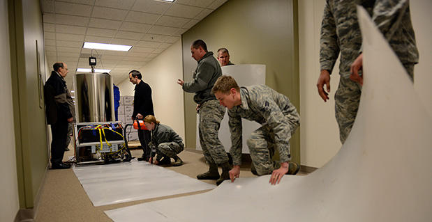
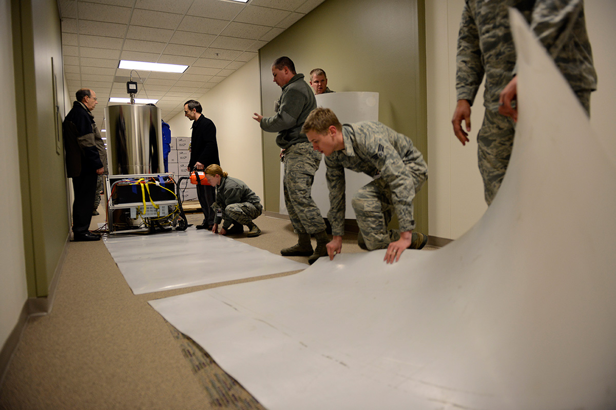
Personnel with the U.S. Naval Observatory-Detachment Colorado and 2nd Space Operations Squadron move the rubidium fountain clock into its new home Tuesday at Schriever Air Force Base. The USNO monitors the GPS constellation and provides time offsets to the 2nd Space Operations Squadron for their daily navigation uploads to each individual GPS satellite. (U.S. Air Force photo/Christopher DeWitt).
The U.S. Naval Observatory’s Alternate Master Clock on Schriever Air Force Base received its second rubidium fountain clock February 4 to ensure it has the most precise time in the world.
Both the USNO’s Washington D.C.-based primary and its local Alternate Master Clock facility serve as the Department of Defense’s common time reference. Additionally, the USNO monitors the GPS constellation and provides time offsets to the 2nd Space Operations Squadron for its daily navigation uploads to each individual GPS satellite.
“With the new rubidium fountain clock, we are going from the time standard of 1 to 2 nanoseconds down to 300 picoseconds,” said Bill Bollwerk, Head of USNO Detachment Colorado.
One nanosecond is equivalent to one billionth of a second, while a picosecond is equal to one trillionth of a second. Though these small slices of time may not sound important, every nth of a second is significant, especially in GPS operations.
“A nanosecond matters because it is equivalent to a 1-foot of error for GPS,” Bollwerk said. “If the GPS satellite clocks were off by 3 nanoseconds, you have 1-meter of error introduced into GPS.”
Designed and produced by physicists at the USNO laboratory in Washington D.C., the powered rubidium fountain clock traveled by dedicated truck to Schriever. Once the fountain clock arrived at Colorado base, with the help of members of the 2nd Space Operations Squadron, the 50th Security Forces Squadron and 50th Civil Engineering Squadron, the USNO team moved it to a climate controlled chamber in the USNO’s laboratory via an airsled hover lifter.
“The 2 SOPS men and women are able to operate and provide accurate instantaneous reliable support to U.S. military forces around the world, thanks to our partnership with the U.S. Naval Observatory,” said Lt. Col. Thomas Ste. Marie, 2 SOPS commander. “We are happy to be able to work together to support their upgrade. Our relationship allows 2 SOPS to continually reach our goal of record breaking time-transfer performance and navigation accuracies.”
Although 2 SOPS was happy to support the move, it’s not as easy as one might think.
“The process of moving the rubidium fountain was very complicated,” said Ken Dreiling, USNO Detachment Colorado. “We had to ensure the fountain clock was not actually in contact with the floor or the walls as we moved it from the loading dock through the hallways and elevator into our facility.”
The careful transport of the fountain was essential to prevent damage that could affect the clock’s performance.
“The fountain clock collects billions of rubidium atoms, encased in a spherical vacuum chamber and laser-cooled to a millionth of a degree above absolute zero degrees Kelvin, approaching the coldest temperature anything can be,” Bollwerk said. “The reason we do that is because we want to observe and measure the atoms for long time in an environment that minimizes unwanted noise like the Doppler Shift.”
Though the Alternate Master Clock provides precise timing for several communication and space systems, Missile Defense Agency, DOD facilities and several civilian infrastructures around the world, the new system was installed primarily to support GPS operations.
“It is great to have the most precise time standard in the world but it is useless unless you can get it to the user, not everyone can come to the facility and set their watch,” said Bollwerk. “GPS is USNO’s primary means of providing global precise time to the warfighter. It is a great partnership between the Navy and the Air Force.”
Dreiling said the new fountain clock will help improve GPS operations.
“The new rubidium fountain clock is the next-generation new frequency standard,” Dreiling said. “This will boost the GPS’s timing by 10-fold.”
By Colonel William T. “Bill” Cooley, U.S. Air Force, Director, Global Positioning System
The cliché “time flies when you’re having fun” accurately describes how quickly the past six months have passed for me. In a program as challenging, rewarding, and mission-critical as GPS, it is full-speed ahead all the time. As the GPS director, I am acutely aware of the importance of time — particularly high-accuracy time. Since declaring initial operational capability in December 1993, the extremely precise time service delivered by GPS has enabled numerous technological advances around the globe. While extremely proud of the accomplishments over the past 20 years, I look forward to the next 20 years, as GPS brings on new signals and continues to deliver on its promise of a worldwide free positioning, navigation, and timing (PNT) service. This article elaborates on the GPS Directorate commitment, along with the 2nd Space Operations Squadron (2 SOPS), to provide unparalleled space-based PNT accuracy, availability, and reliability to the civil community.
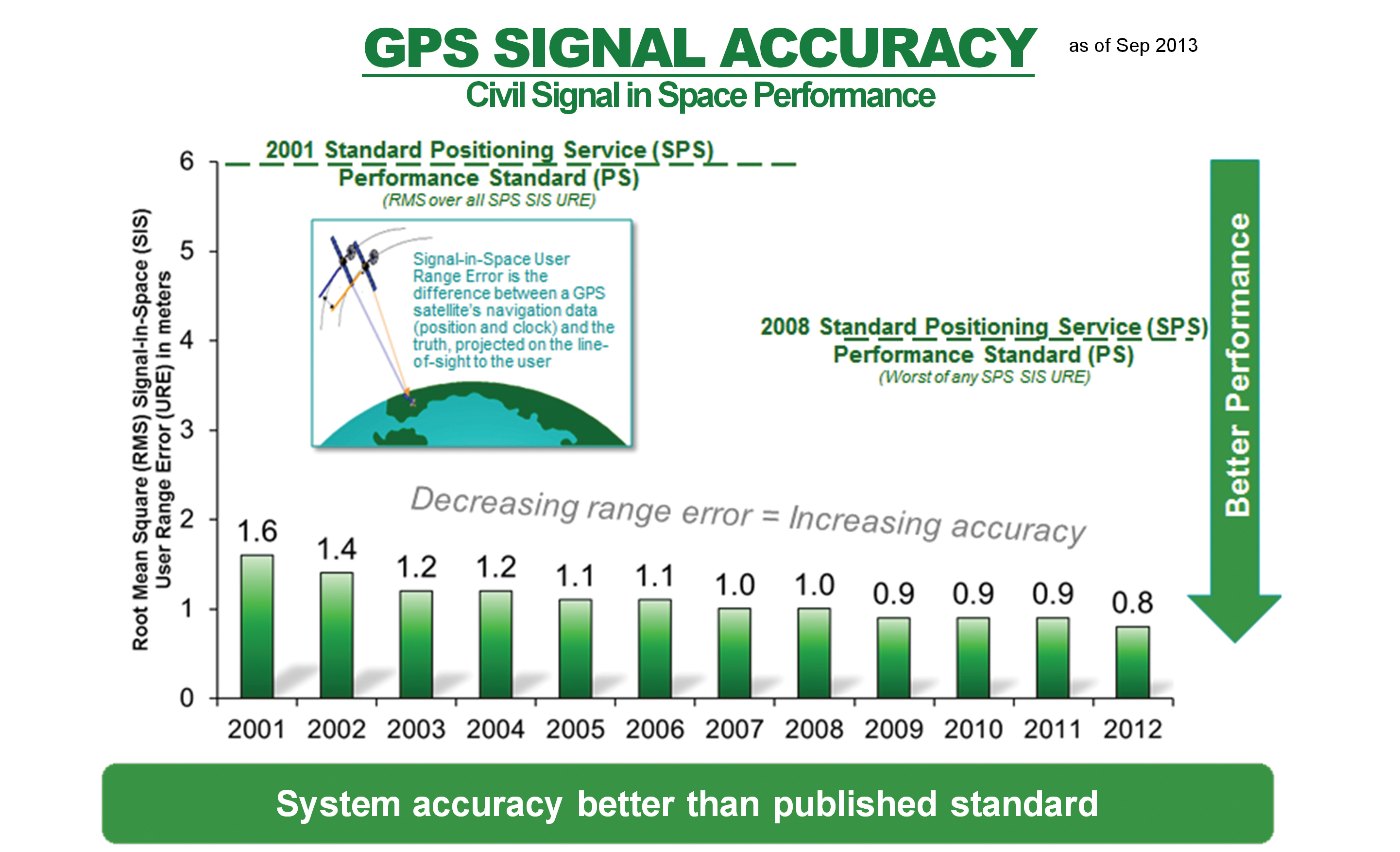
The first commitment, arguably the most important for users everywhere, is the commitment to high accuracy for space-based PNT. After speaking at the ION GNSS+ conference and meeting many of you in Nashville this September, I realized that some users remain worried that selective availability (SA) — the intentional degradation of public GPS signals — could return and negatively impact GPS signal quality. SA was discontinued in May 2000 to provide an increased level of accuracy to all users around the globe. Since that time, the U.S. government has adopted a policy to no longer use SA and, furthermore, in 2007 removed that function from the upcoming GPS III satellites. The GPS Performance Standard for the Standard Positioning Service reflects our commitment to accuracy by ensuring the signal-in-space (SIS) user range error remains low: better than 4-meter accuracy. Figure 1 shows the record-setting SIS accuracy and how GPS meets and far exceeds this guarantee: consistently better than 1-meter accuracy! The 2 SOPS operators who command and control the GPS satellites do a masterful job ensuring global PNT accuracy is as good as it can be.
Figure 1. Standard Positioning Service signal-in-space performance.
The quality of these services, however, does not permit the GPS enterprise to rest in the comfort of past success. We are dedicated to updating and modernizing the program.
The second commitment I’d like to highlight includes the GPS pledge for constellation sustainment and service availability. This is a guarantee to maintain a constellation of at least 24 satellites continuously broadcasting the GPS signals, providing a low dilution-of-precision value around the globe. Current efforts to meet this commitment range from replenishing unhealthy satellites to deploying improved, modernized satellites and corresponding ground support. For example, the GPS IIF satellites are rapidly becoming an integral part of the GPS constellation. With four IIFs on-orbit and a fifth soon to be launched, the constellation continues to exceed the 24-satellite requirement.
The third commitment — to modernize the GPS constellation with new signals — is best illustrated by, but not limited to, the modernized GPS IIF and GPS III satellites that are beginning to populate the constellation. In addition to four GPS IIF satellites now on orbit, the remaining GPS IIFs are either ready for launch or in final testing.
Down the road, GPS III satellites are completing development and progressing through early production. They will add the fourth civil signal, L1C, for civil users worldwide. Earlier this year, the GPS III program shipped the GPS non-flight satellite testbed (an engineering development unit) to Cape Canaveral; it successfully communicated with the next-generation operational control system (OCX), essentially as it would for launch and on-orbit check and control of functional GPS III satellites. The operational portion of the GPS ground segment, OCX Block 1 is on track to begin operations in 2016, modernizing the control segment by providing mission operation control of all legacy signals, as well as L2C and L5; later, OCX Block 2 will support L1C.
GPS civil users will soon be able to take advantage of the L2C and L5 signals that broadcast the modernized civil navigation message (CNAV); this will effectively eliminate the need to access the L1 and L2 P(Y) signals through codeless or semi-codeless techniques. These codes permit civil users to access dual-frequency solutions for precision applications (using dual-frequency enables ionospheric corrections for highly accurate PNT solutions). Compared to the L1 C/A signal, L2C features faster signal acquisition, enhanced reliability, and greater operating range. L5 will provide for increased safety-of-life applications with broadcast power even greater than L1 C/A and L2C combined, increased bandwidth, and advanced signal design. Regardless of the early availability of L2C and L5, semi-codeless users will be able to access P(Y) code — unhindered and unaffected by fully tested and vetted flex-power operations — until the end of 2020. Overall, these modernization efforts emphasize a commitment that availability surpasses simply putting satellites on orbit.
Finally, the GPS Directorate is committed to providing a high-quality service that is highly reliable. We achieve this by fielding first-rate satellites, conducting extensive test campaigns before deploying new capabilities or launching new satellites, and working closely with the operators at 2 SOPS, ensuring our constellation delivers top-quality PNT signals. An example of diligent testing is the recent live-sky test of the CNAV message on all GPS IIR-M and IIF satellites this past June. An example of a modernization feature that will enhance reliability is the capability of GPS III satellites to autonomously monitor the atomic clocks that drive the signal, thereby protecting users from clock instability and resulting signal errors.
Our demonstrated commitment to deliver accurate, available, and reliable space-based PNT allows innovators around the world to invest confidently in the creation of a multitude of GPS and GPS-enabled technologies that shape the way we live. GPS and its related technologies go far beyond letting you find the deli down the street and “checking in” to let your friends know what you’re up to on Facebook; it tracks financial transactions, enables precision farming, and allows accurate real-time updates on natural disasters such as earthquakes and tsunamis with capabilities that organizations like the NASA Jet Propulsion Laboratory and the International GNSS Service provide using GPS. The GPS Directorate is keenly aware that innovators invest their time and talent because they know they can depend on GPS availability. Our commitments are not just “feel-good” words; they are our mission and promise to the world.
I am very proud of the men and women in the GPS Directorate and thrilled to be part of this great team as the new GPS program director. The commitments listed here provide a glimpse into the services provided by the GPS enterprise. I am excited about bringing modernized signals to the world, but more excited to learn how the PNT community will use these signals to develop new innovative and useful applications. The world is easier to navigate because of GPS and GPS-enabled technologies, all of which rely on services the GPS enterprise provides: accuracy, availability, and reliability. We are committed to delivering these services as we modernize and improve the enterprise to continue GPS as the gold standard of space-based PNT.
Colonel William L. cooley is Director, Global Positioning Systems (GPS) Directorate, Space and Missile Systems Center, Air Force Space Command, Los Angeles Air Force Base, California.