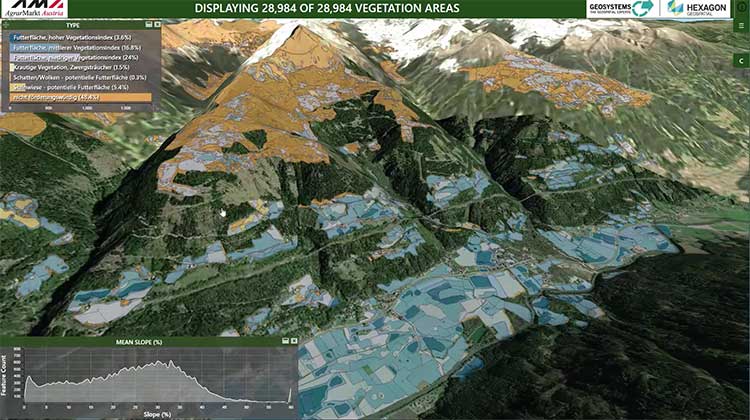
Hexagon’s Geospatial Division launched M.App Enterprise 2019 at its user conference, HxGN LIVE 2019. The latest version of M.App Enterprise integrates capabilities from Hexagon’s Luciad Portfolio to enhance data visualizations, analytics and management.
Designed to monitor assets, evaluate changes, and take action, M.App Enterprise is a privately-hosted platform that allows organizations to deploy Hexagon Smart M.Apps that dynamically address their location-based business problems.
The new features in M.App Enterprise 2019 lay the foundation for users to experience a 5D smart digital reality, where data is connected seamlessly through the convergence of the physical world with the digital and intelligence is built into all processes.
Screenshot: Hexagon Geospatial
“The enhanced M.App Enterprise is now powered by our Luciad technology, which allows users to have the best of both worlds when it comes to data visualization and advanced analytics to communicate information effortlessly, and in real-time,” said Georg Hammerer, chief technology officer – applications for Hexagon’s Geospatial Division. “This unified geospatial enterprise platform can now further enable users and partners to create vertical solutions for their markets and industry segments.”
The Luciad Portfolio integration will allow users to connect to, visualize and examine file-based vector and raster data from their Smart M.Apps in 3D. It also now renders terrain features realistically based on elevation data of the area.
For covering large geographical areas with a higher resolution, M.App Enterprise 2019 allows users to connect to tiled elevation coverages offered by LuciadFusion.
Furthermore, the addition of classification algorithms to the Spatial Workshop user interface enables M.App Enterprise to perform advanced remote sensing with machine learning.
Aerial imagery business Nearmap has launched its new 3D product to streamline the way industries such as urban planning, architecture, construction, government and councils view and shape cities across Australia and the U.S.
The company is also previewing its groundbreaking artificial intelligence (AI) technology at its customer event Navig8.
Nearmap 3D allows customers to stream and export 3D imagery on demand at massive scale through its proprietary MapBrowser web application. Because the imagery is updated frequently, businesses can work with the most current information to make more informed decisions.
Nearmap’s new AI technology is turning millions of aerial images — captured over a decade and multiple times a year — into valuable datasets. The datasets can be used to more accurately and efficiently measure change and quantify attributes, such as solar panels, pools, roofs or construction sites.
Organizations ranging from small businesses to large companies and cities will be able to take advantage of AI-driven location intelligence.
“Product innovation is in our DNA. Everything we do has the customer at the core,” said Tony Agresta, executive vice president of product at Nearmap. “Our customers’ worlds are evolving every day. We need to keep innovating to continue to give our customers a competitive advantage through technology breakthroughs like the ones we are sharing today at Navig8.
“Nearmap 3D is the result of a significant investment in R&D, but also listening to our customers and what they need to transform the way they work,” Agresta said. “Accessing 3D imagery up to now has typically been an arduous, time-consuming and expensive process — but not anymore. This represents the single largest, most frequently updated footprint of 3D accessible through a browser. The ability to measure in 3D space, size up an area and then export Nearmap 3D for use in other platforms will transform the aerial imagery market.
“The AI technology that we’re working on will allow organizations to identify locations with specific attributes and in so doing, reduce site visits, generate more leads, and eliminate the time involved to inspect properties manually. Nearmap AI does the heavy lifting so you don’t have to,” Agresta said.
Composite aerial image of Perth, Australia. (Image: Nearmap)
Instant access to 3D through MapBrowser
Nearmap is making 3D imagery accessible to anyone, in the same way it has with 2-D. While Nearmap has offered 3D imagery since 2017, this new iteration of the technology allows users to instantly stream 3D content at massive scale via its MapBrowser web application.
The lightweight platform offers customers an immersive 3D experience, allowing them to visualize cities in 3D from any direction, measure distances, and immediately export a custom area in a variety of 3D formats at unprecedented speed — the download time is a matter of minutes for most requirements and only a few hours for very large footprints.
“It’s like switching from DVDs to streaming services,” said Tom Celinski, executive vice president of technology and engineering at Nearmap. “Our camera technologies have been capturing 3D since 2017, but now our secret sauce is bringing it onto MapBrowser, allowing users to easily and instantly stream this content with many export options. Now users can visualize, measure, define a custom area, export our 3D and use it in their workflows with other commercial platforms and tools. We’re helping 3D experts and novices alike access reality like never before, and this is an important next step in our Reality as a Service journey.”
Nearmap 3D comes with an extensive library, covering more than 400,000 square kilometers. It is updated once a year and covers major urban areas in Australia and the U.S.
“We live in a 3D world, we think in 3D, and so we have to ensure that our products give the closest representation of reality as possible,” Celinski said. “That means businesses that rely on visualizing 3D content, like architects, for example, can now access up-to-date 3D models instantly and export them in just minutes. In a tender process, for example, that can be the difference between winning a new project or not. The opportunities for Nearmap 3D are endless.”
3D image of Manhattan. (Photo: Nearmap)
A living data set
Nearmap AI technology is the result of more than two years’ worth of research and development, and a team of close to 20 data scientists and machine learning engineers. The team, led by Dr. Michael Bewley, is using the petabytes of imagery that the business has captured over the past 10 years and turning it into a living dataset to accurately identify changes or quantify attributes from the Nearmap library of aerial imagery.
Nearmap has built highly accurate machine learning models and deployed them on a massive scale. The automated process, and the constantly learning engine, means that the AI technology can be applied to any new geography. Nearmap also applies the models to new surveys, generating fresh results with current imagery.
To date, Nearmap has performed analysis on over 1 million square kilometers of imagery across Australia and the U.S. (which constitutes about 80 million properties) and is performing more analysis every day. Nearmap is now inviting customers to take part in a beta program to experiment with various use cases.
“We don’t prescribe how our technologies or content can be used by our customers,” said Michael Bewley, director of AI systems at Nearmap. “Our solar customers could use the AI technology to easily identify where and when solar panels have been installed for maintenance jobs, to prospect new clients in an area where solar energy’s popularity is on the rise; or a government entity that previously had the arduous task of tracking swimming pools or construction in their jurisdictions will be able to do it automatically.”
“But this is the tip of the iceberg — we’re just getting started. This technology is going to profoundly change the way that cities are built,” Bewley said. “Our plans include delivering AI results in many forms, much the same way we deliver our imagery today.”
Both technologies will be presented at Nearmap’s flagship event, Navig8, in Perth on June 6, Melbourne on June 11 and Sydney on June 13.
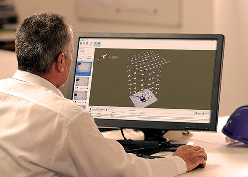
MAGNET Inspect is designed for UAV data collection. (Photo: Topcon)
Topcon Positioning Group has introduced software to facilitate the data-processing workflow for UAV (unmanned aerial vehicle) infrastructure inspection.
MAGNET Inspect efficiently manages large UAV data sets to create inspection reports. It is designed to allow operators to easily visually navigate UAV photos, aligning 3D reality meshes with raw georeferenced images in one location and filtering them based on selected criteria including field of view.
“MAGNET Inspect will work with models from virtually any UAV,” said David Ahl, director of software product management. “When combined with Intel Falcon 8+ Drone – Topcon Edition and Topcon ContextCapture, powered by Bentley Systems, the software enables operators to efficiently navigate, annotate and create reports with inspection photos, effectively creating a very strong end-to-end inspection workflow.
MAGNET Inspect is now a key element of the Topcon end-to-end UAV and data processing workflow for inspection projects, Ahl said. It’s use aims to increase safety and speed data collection compared to traditional methods.
“The software allows operators to easily document the observations and report them. Images from the inspection can be flagged to indicate whether there are structural issues and annotated with built-in free-hand graphical tools. Data reports can then be created to include a preview image and link to high resolution annotated image,” Ahl said.
The ThunderBuild program. (Photo: Topcon/ThunderBuild)
Acquisition of ThunderBuild. In another announcement, Topcon announced the acquisition of ThunderBuild BV Group, expanding the portfolio of Topcon paving solutions. Based in Eindhoven, the Netherlands, ThunderBuild develops software related to logistics management with a primary focus in the asphalt market, as well as additional applications that pertain to the transport of bulk materials.
Bentley Systems, a global provider of comprehensive software solutions for advancing infrastructure, has acquired Plaxis, provider of geotechnical software, based in Delft, Netherlands.
Bentley has also agreed to acquire soil engineering software provider SoilVision, based in Saskatchewan, Canada.
The acquisitions, with Bentley’s market-leading borehole reporting and data management software gINT, serve to make Bentley a complete digital source for geotechnical professionals.
With the acquisitions, building information modeling (BIM) advancements can be extended to the essential subsurface engineering of every infrastructure project.
Projects necessarily begin with geotechnical surveys and sampling, captured with gINT for versatile documentation and reporting.
Next, professionals perform engineering related to soil properties, soil behavior, and groundwater flow using SoilVision’s SVOFFICE applications, supplemented by Plaxis’ offerings.
Then, soil-structure interaction is analyzed through Plaxis’ design, simulation, and engineering software (for example, PLAXIS 2D, PLAXIS 3D).
The new opportunity, by way of digital workflows enabled through Bentley’s comprehensive modeling environment, is for geotechnical applications to be integrated with Bentley’s structural applications (such as STAAD, RAM and SACS) for unprecedented geo-structural engineering performance.
As changes may occur in owner requirements, structural strategies or site conditions (continuously surveyed through UAVs and Bentley’s ContextCapture for reality modeling), geotechnical analysis could be continuously applied for improved outcomes, as managed through ProjectWise collaboration services.
For today’s infrastructure demands, geotechnical considerations are coming to the fore.
Urbanization, for instance, drives growth both vertically and underground, with emphasis on the capacity of foundations and tunnels. And new infrastructure projects of every type depend upon constructed dams, embankments, dikes, levees and reservoirs to improve their resilience.
Moreover, new asset types such as offshore wind turbine structures require new geotechnical analysis capabilities, in this case to be accomplished with Plaxis’ forthcoming MoDeTo software.
Because infrastructure assets are crucially linked to subsurface environs, they are vulnerable to geo-environmental risks including seismic activity, subsidence and weather impacts. Leveraging new digital workflows which incorporate real-time monitoring and analytics during infrastructure operations, geotechnical professionals can play the increasingly valuable role they deserve in achieving geo-environmental resilience.
“My colleagues and I welcome our new teams from Plaxis and SoilVision, which have in common a zeal for applying science for better engineering practice,” said Greg Bentley, Bentley Systems CEO. “Dr. Ronald Brinkgreve from Plaxis and Dr. Murray Fredlund, founder of SoilVision, exemplify this. I believe that every geotechnical engineer has benefitted from Plaxis’ continuous advancement, in scope and quality, of tools for their discipline to add value. With a professional and dedicated management team led by Jan-Willem Koutstaal, Plaxis has become one of the most successful software businesses I have ever seen.”
Bentley added, “While most infrastructure engineering disciplines converged around intuitive 3D models, geotechnical applications seem to have followed a less graphically intensive development path, and so have remained isolated from cross-discipline workflows. This ‘disconnected’ mindset prevailed even while Plaxis, SoilVision, and gINT mainstreamed 3D innovations. Our BIM platform’s comprehensive modeling environment will finally embrace the geotechnical profession in digital workflows for every infrastructure project and asset.”
Tony O’Brien, global practice leader for geotechnics for Mott MacDonald, said, “PLAXIS is one of our core analysis tools being used across our global geotechnics practice. When used by experienced specialists, PLAXIS can analyze many of our most complex ground-structure interaction problems. In Bentley’s hands, we have high expectations that we can accomplish more through digital workflows made possible through integration of PLAXIS technology with Bentley’s comprehensive modeling environment—workflows that are compatible with Mott MacDonald’s commitment to connected thinking and solving complex infrastructure challenges.”
ArcGIS Pro 2.0, Esri’s next-generation desktop geographic information system (GIS), is now available. This latest version provides more highly requested workflows and features new innovations.
It is also more tightly integrated with the rest of the ArcGIS platform, so that users can complete more of their workflows solely in ArcGIS Pro.
Jack Dangermond, Esri president, introduced major features of the upgrade at the Esri User Conference plenary July 10. The Esri User Conference takes place in San Diego July 10-14. Several focused sessions at the conference will explore the updates to ArGIS Pro.
Highlights of ArcGIS Pro 2.0 include the following.
Workflows
The user’s favorite workflows are now easier and more powerful in ArcGIS Pro 2.0. Users can perform more complete workflows solely in ArcGIS Pro, such as map creation and data management.
Create more effective and meaningful maps with annotation and grids.
Getting started with new ArcGIS Pro projects has vastly improved with Favorites.
Modify topology properties directly in ArcGIS Pro.
Enhanced traverse tool improves COGO workflows.
Highly requested context menu options for importing and exporting data included in the Catalog pane.
Users of ArcGIS Pro can now create map notes in 3D in a scene.
Innovations
ArcGIS Pro 2.0 features the following innovations.
Explore 3D landscapes with new 3D navigation controls, and sync the views of 3D and 2D maps.
Layouts are more useful and powerful with embeddable dynamic interactive charts.
Improvements to 3D drawing including feature drawing by camera distance and enhanced lighting of 3D objects make 3D visualizations even better.
Analytics improvements with fill-missing-values tools and enhanced spacetime cubes.
Get more done with new geoprocessing tools.
ArcGIS Platform Integration
ArcGIS Pro 2.0 works better with the rest of the ArcGIS platform, including ArcGIS Online, ArcGIS Enterprise and Esri’s library of ready-to-use apps. Cross-platform workflows are now easier and more powerful than ever.
Enhancements for editing and interacting with the geodatabase in the ArcGIS Pro 2.0 SDK.
Consume native OGC Web Feature Service (WFS) Services directly in ArcGIS Pro.
Sync with feature layers that reference data registered in Portal for ArcGIS 10.5.1.
Vertical coordinate systems are included when sharing web scenes and web scene layers.
Continue to work in ArcGIS Pro while packaging operations complete in the background.
Get the full details on what’s new in ArcGIS Pro 2.0.
Leica Geosystems’ BLK360 is a miniaturized black 3D imaging laser scanner. The BLK360 captures the world with full-color panoramic images overlaid on a high-accuracy point cloud.
The one-button Leica BLK360 is easy to use, Leica said. Anyone who can operate an iPad can now capture the world around them with high-resolution 3D panoramic images.
The Leica BLK360 imaging laser scanner is so small and light that it fits in a typical messenger bag. It features a 60-meter measurement range for full dome scans. A complete full-dome laser scan, 3D panoramic image capture and transfer to the iPad Pro takes only 3 minutes.
Using the ReCap Pro 360 mobile app, the BLK360 streams image and point cloud data to iPad. The app filters and registers scan data in real time. After capture, ReCap 360 Pro enables for point cloud data transfer to a number of computer-aided design, building information modeling, virtual reality and augmented reality applications. The integration of BLK360 and Autodesk software streamlines the reality-capture process, opening the technology to non-surveying individuals.
The BLK360 is now available for reservation in Europe.
Leica Geosystems’ BLK360 miniaturized 3D imaging laser scanner is now available for reservation within Europe, for delivery in summer. The laser scanner simplifies the collection of as-built reality capture data for work in architecture, design, construction and engineering among other vertical markets.
The Leica BLK360 is an easy-to-use and powerful reality-capture solution that enables professionals to capture 360-degree HDR spherical imagery within minutes. Users place the lightweight BLK360 on a level surface or tripod and, with the push of a button, it captures 360-degree HDR spherical imagery and takes a 360,000 point per second laser scan.
The BLK360 features +-4 mm accuracy at 10 meters and an overall 0.6–60-meter range. Within three minutes, the spherical image and laser scan is completed and ready to view in the Autodesk ReCap Pro for mobile app, which runs on an iPad Pro. From there, users can take measurements, add markup and annotations or share onsite data with their colleagues back in the office.
“If you’ve ever relied on pencil and paper, tape measures, or other laser measuring devices to capture a room’s dimensions and images, you know that there’s always redundancy and missed measurements,” said Steven Gross, architectural engineer, Valley Home Improvement. “With the BLK360 those issues disappear. Everything is captured on the first visit, which streamlines the process, saving us enormous amounts of time. Not to mention that it makes us look that much more professional to our clients.”
“The BLK360 brings together exclusive technologies to deliver outstanding performance, all while simplifying the process of 3D image scanning and reality capture through the touch of a single button,” said Burkhard Boeckem, CTO, Leica Geosystems. “This has enabled us to create new opportunities for scanning experts and introduce entirely new audiences to laser scanning while uncovering possibilities that were previously unimaginable.”
The BLK360 has already earned several prestigious industry awards including the PRISM Award for Photonics, iF Design Award, the Red Dot Design Award, and the Geospatial World Innovation Award, and was also a CES Innovation Award nominee.
Icaros Inc., a provider of aerial remote sensing services and software, has announced that Harris Geospatial Solutions, a division of Harris Corporation, will offer the Icaros OneButton family of image processing software as a front-end complement to its ENVI geospatial analytics solution for users extracting information from manned and unmanned aerial sensor data.
“Together, OneButton and ENVI create a complete image processing and analytics workflow for aerial image data,” said Tom Bosanko, Icaros CEO. “Both packages are highly customizable to meet the needs of specific vertical market applications.”
Icaros developed the OneButton family for geospatial end users to easily and automatically generate precise, fully orthorectified 2D maps and 3D models from frame-based aerial imaging systems. Originally engineered for manned aircraft sensors, the OneButton software has been modified to accommodate the collection conditions of unmanned aerial systems (UAS).
“The combination of OneButton and ENVI provide best-of-breed, application-specific image processing and analytics, that enable customers to solve challenging problems related to everything from agriculture and forestry to utilities and city planning,” said Beau Legeer of Harris Geospatial Solutions.
OneButton automatically processes raw raster imagery with onboard GPS/IMU data to stitch the individual scenes together into a seamless, color-balanced orthomosaic meeting photogrammetric standards.
Outputs include digital elevation models (DEMs), true color 3D point clouds, multispectral mosaics and controlled oblique imagery — all ready for ingest directly into the ENVI software environment.
OneButton comes in both Standard and Professional versions. The Standard package asks the end user to specify the application and terrain type for the project at hand. The software then intuitively sets parameters of the photogrammetric engine to perform the mosaicking to the level of precision required. For example, the processing algorithms would handle flat agricultural fields different from a rolling urban landscape.
“The Professional version is more customizable, allowing end users to adjust the processing parameters themselves based on the precision they need, and then edit the resulting mosaic to remove anomalies, like an airplane moving down a runway. OneButton Professional was specifically designed to generate results with the efficiency and accuracy necessary for large scale projects and survey-quality results,” Bosanko said.
OneButton is platform and sensor agnostic, and processes raster image data from small-, medium-, and large-format frame sensors capable of capturing visible RBG, multispectral, near-infrared and thermal infrared data.
The OneButton solution for ENVI is available now to existing and new customers, and both companies expect further technology integration in the near future around cloud enablement of the UAS data processing and analytics workflow.
Mapillary has released a video showing 3D models of locations its users photograph. The company said this gives users “the power to virtually explore their own photos like never before.”
According to a Mapillary blog, “Our users have taken over 40 million photos to date. Each of these are stitched together with computer vision – a type of artificial intelligence that extracts information from images. For every single photo uploaded, we can automatically match features to the ones in photos from the same geographic vicinity so that we can compute how the images relate to each other and how to navigate from one to the other. This is how users navigate between photos in the Mapillary app and web browser.
“Taking it one step further, we can also recover a 3D model of every area photographed. What began as a means to improve positioning of each photo beyond the GPS accuracy given by smartphones turned out to be quite an magical viewing experience.
“We couldn’t keep this to ourselves so now users can explore our underlying 3D data by simply clicking the ‘show point clouds’ option in the sidebar in your web browser. We’ve also added full support for panoramas, which enables users to move seamlessly between regular photos and panoramas in 3D, giving them a smooth and other-worldly viewing experience.”
The video shows the 3D data collected from a user walking across the courtyard at the Alcazar Palace in Seville, Spain. The camera positions are shown as white rectangular frames.
Microsoft will no longer collect its own map data, according to the website re/code. As part of the change, Microsoft is selling some of its assets to rideshare company Uber, including a data center, cameras, intellectual property and roughly 100 engineers. Uber is also buying a data center near Boulder, Colo.
Microsoft plans to continue to offer Bing Maps using data licensed from partners.
Microsoft already gets much of its map data from Nokia and other partners, but had been collecting its own aerial, 3D and street-level maps. It will now source those images from partners, focusing its Bing Maps work on the user experience that overlays the map data and imagery.
Industry watchers suggest the cameras might soon end up on the roofs of Uber vehicles. Uber already has hundreds of thousands of cars being tracked around the world every day.
Flightline Geographics and Tablerock Land Survey have partnered to provide industry-leading premium 3D aerial imagery from Unmanned Aerial Systems (UAS) for pipeline and electric transmission projects across North America. The announcement was made at the International Right of Way Association annual conference and trade show.
FlightlineGeo is a GIS company that has been involved in professional UAS since 2012 and is able to provide base mapping and 3D terrain modeling through the use of drones for energy corridors and other areas of interest. Resolution and delivery times are far better than traditional manned sources and costs are significantly lower. “GIS is a technology that depends upon up-to-date content and UAS is now a cost-effective way to provide aerial visual intelligence for GIS, in the form of stunning 3D Imagery. All delivered in days, not months,” said FlightlineGeo Founder and CEO Devon Humphrey.
Tablerock provides complete survey, right-of-way, and project management/inspection services for projects of all sizes. “One of the challenges we have faced has been obtaining current aerial imagery and topographic information that meets industry needs for project design and GIS within the United States. On most projects, our clients are limited to whatever current satellite imagery is available on the Internet, but it is often dated and of low quality. Content from FlightlineGeo changes all that,” said Andrew Darlington, President of Tablerock Land Survey.
FlightlineGeo is an ESRI Partner Network Company based in the Austin, Texas, area, and Tablerock Land Survey is based in Denver, Colo.
Flightline Geographics is a GIS company that has been involved in professional UAS since 2012 and provides base mapping and 3D terrain modeling through the use of UAS for energy corridors and other areas of interest.
“GIS is a technology that depends upon up-to-date content, and UAS is now a cost-effective way to provide aerial visual intelligence for GIS in the form of stunning 3D imagery. All delivered in days, not months,” said Flightline Geographics’ founder and CEO Devon Humphrey.
Tablerock provides survey, right-of-way and project management/inspection services.
“One of the challenges we have faced has been obtaining current aerial imagery and topographic information that meets industry needs for project design and GIS within the United States,” said Andrew Darlington, president of Tablerock Land Survey. “On most projects, our clients are limited to whatever current satellite imagery is available on the Internet, but it is often dated and of low quality. Content from FlightlineGeo changes all that.”
Flightline Geographics is an Esri Partner Network Company based in the Austin, Texas, area and Tablerock Land Survey is based in Denver.