Tag: 3D laser scanning

  • Trimble joins with Exyn on autonomous surveying solution

    Trimble joins with Exyn on autonomous surveying solution

    Trimble and Exyn Technologies are developing multi-platform robotic autonomy for complex, GPS-denied environments. (Photo: Trimble)
    Trimble and Exyn Technologies are developing multi-platform robotic autonomy for complex, GPS-denied environments. (Photo: Trimble)

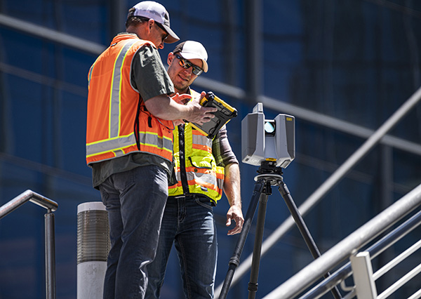
    Trimble and Exyn Technologies are working on a proof of concept for a fully autonomous surveying solution for construction.

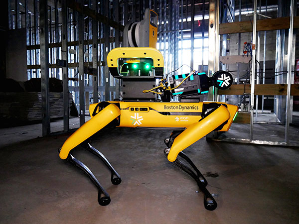
    The solution will integrate the Boston Dynamics Spot robot, the ExynPak powered by ExynAI, and the Trimble X7 total station. It will enable fully autonomous missions inside complex and dynamic construction environments, which can result in consistent and precise reality capture for production and quality-control workflows.

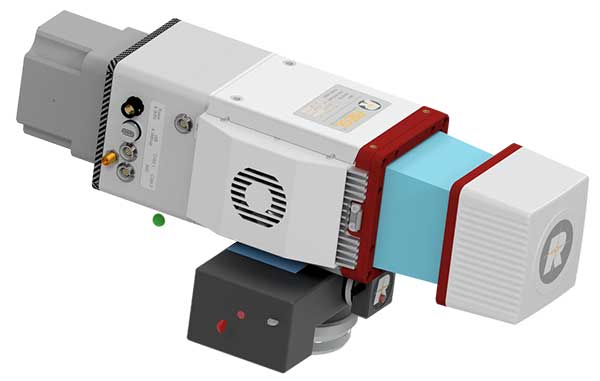
    Autonomous robots powered by ExynAI can sense and avoid obstacles, dynamically adapting to the complexity of construction environments. To ensure safety and efficiency, the ExynPak integrates with a robot, supporting Level 4 of autonomous exploration missions without requiring the robot to “learn” about its environment beforehand.

    A surveyor can define a 3D volume for a mission, and then the integrated robotic solution handles the complexities of self-navigation without needing a map, GPS or wireless infrastructure.

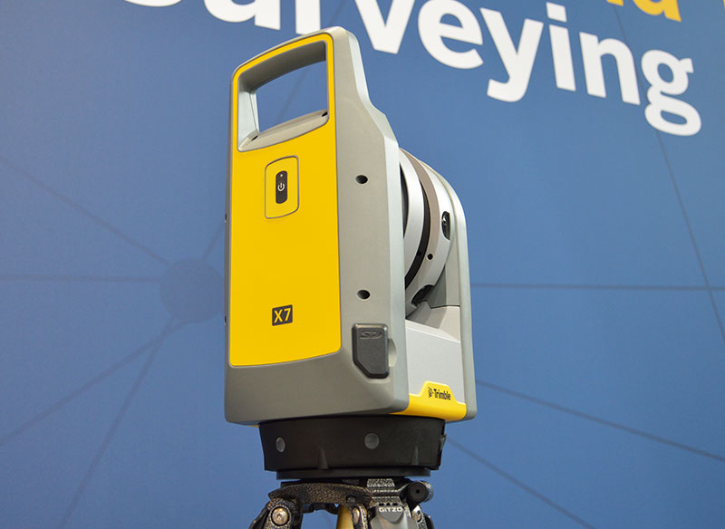
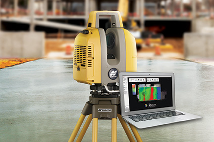
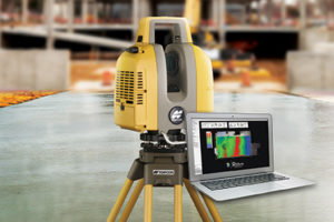
    The integration of the Trimble X7 provides high-speed, high-accuracy 3D laser scanning to capture the state of the environment. The captured data can be uploaded to the Trimble Connect collaboration platform and shared with project stakeholders for further analysis, including a comparison to building information models (BIM) and previous scans to monitor quality and progress. The result is a detailed and accurate map collected with minimal human intervention and risk.

    Exyn and Trimble will be demonstrating their technology at the Trimble Dimensions+ Conference Nov. 7-9 in Las Vegas.

  • Scanning solution from Trimble simplifies 3D deliverables

    Scanning solution from Trimble simplifies 3D deliverables

    Photo: Trimble
    Photo: Trimble

    Trimble has introduced the Trimble X12 scanning system to the geospatial scanning portfolio. The X12 integrates intuitive Trimble software for precise data capture and in-field registration with 3D laser scanning and imaging hardware technology from Zoller+Fröhlich (Z+F), combining the expertise of two industry leaders into a single solution.

    The Trimble X12 can be operated by using Trimble Perspective field software installed on a Trimble T10x tablet to enable registration and refinement of scans in the field, ensuring project accuracy and completion before leaving the jobsite. Users can also leverage Trimble’s customized onboard software menu to configure and operate the scanner.

    Data is exported from the field and processed in the office with Trimble RealWorks software or third-party software. Final deliverables can be shared online with clients and stakeholders using Trimble Clarity, a browser-based data collaboration and visualization tool.

    Transforming high-quality 3D data into decisions — such as using scans, models and imagery to determine the structural integrity of aging infrastructure — is streamlined with the Trimble X12 because the data can reside within the Trimble software ecosystem. This allows users to easily visualize, manage and evaluate the project throughout the entire workflow, even for beginners and new users to scanning technology.

    With features including range (from 0.3 up to 365 meters) and scan speed of up to 2.187 million points per second, the Trimble X12 produces scan data and images with high quality and clarity, complementing the Trimble X7’s capabilities within the scanning product portfolio.

    “The Trimble X12 puts the most advanced 3D scan and image capture within reach for a variety of skill levels,” said Jacek Pietruczanis, business area director for Scanning and Mobile Mapping, Trimble Geospatial. “The system enables advanced scanning professionals to improve their productivity with top-of-the-line performance and efficiency gains, while those new to scanning can easily unlock this advanced capability with the touch of a button.”

  • Riegl launches lightweight airborne lidar for UAVs

    Riegl launches lightweight airborne lidar for UAVs

    The miniVUX-2UAV airborne laser scanner. (Photo: Riegl)
    The miniVUX-2UAV airborne laser scanner. (Photo: Riegl)

    The Riegl miniVUX-2UAV is a lightweight airborne laser scanner designed specifically for integration with unmanned aerial vehicles and systems.

    Riegl added the new miniaturized UAV sensor to its portfolio of professional solutions for UAV-based surveying.

    The sister type of the miniVUX-1UAV sensor, the miniVUX-2UAV offers 100 kHz and 200 kHz PRR. With the 200-kHz PRR, the sensor provides up to 200,000 measurements per second, and thus a dense point pattern on the ground for UAV-based applications that require the acquisition of small objects.

    The Riegl miniVUX-2UAV makes use of Riegl waveform lidar technology, allowing echo digitization and online waveform processing. Multi-target resolution is the basis for penetrating dense foliage, and the wavelength is optimized for the measurement of snowy and icy terrain.

    In addition to the stand-alone version of the miniVUX-2UAV, Riegl also offers fully-integrated solutions.

  • Trimble launches X7 3D laser scanner at Intergeo 2019

    Trimble launches X7 3D laser scanner at Intergeo 2019

    The Trimble X7 is designed for surveying, construction, industrial and forensic applications. (Photo: Allison Barwacz)
    The Trimble X7 is designed for surveying, construction, industrial and forensic applications. (Photo: Allison Barwacz)

    Trimble has released its X7 3D laser scanning system at Intergeo 2019, which took place Sept. 17-19 in Stuttgart, Germany. According to the company, the system is designed to enable professionals of all scanning levels to quickly and easily capture precise 3D scanning data to produce high-quality deliverables.

    The X7 is designed for surveying, construction, industrial and forensic applications. The scanner features Trimble X-Drive technology, survey-grade self-leveling and a smart calibration system.

    “We are really excited to bring the X7 to the market,” Gregory Lepere, marketing director, optical and imaging, Trimble, told GPS World. “It’s a very simple solution but offers a lot of smart technology. Every time you turn the instrument on, the automatic calibration will start, so you’re guaranteed to have all of the specifications all of the time.”

    It also integrates streamlined workflows to provide automatic registration of point cloud data in the field with Trimble Registration Assist.

    “The feature bringing the most simplicity to the solution is the Trimble Registration Assist technology, which is a full registration in the field, bringing all of the scans together thanks to self-leveling IMU technologies combined with cloud-based software,” Lepere said.


    Survey applications

    For surveyors and geospatial professionals, the X7 provides fast and balanced performance in both indoor and outdoor environments and is ideal for industrial survey/tank calibration, civil infrastructure, general surveys, road intersection surveys, utilities, mining, and historical documentation and renovation, Trimble said.

    The X7 is fully integrated with the Trimble Perspective software, which enables scans and images to be captured, fully registered together, refined, controlled and exported to a variety of established data format for Trimble and non-Trimble software suites.

    Building design and construction applications

    For users in building design and construction, the X7 assists with measurement problems and improves field productivity for a broad range of applications in architecture, engineering and construction industry projects.

    For these applications, the X7 is fully integrated with Trimble Field Link software to provide streamlined workflows specific to the building construction industry — from scanning to modeling to field layout.

    Forensics applications

    According to Trimble, the X7 can perform in demanding conditions and offers easy setup for investigators and law enforcement. It also pairs with the company’s Trimble Forensics Capture software.

    The Trimble X7 is expected to be available in the first quarter of 2020.

    In addition, the company announced the availability of its SiteVision augmented reality system at Intergeo.

  • Laser scan data improves response in active shooter simulation

    A security technology firm reduced the time needed for public-safety personnel to engage a simulated active shooter by providing the team with site floorplans created from 3D laser scan data.

    Before the exercise, the firm scanned the entire 112,000-square-foot building interior in just 2.5 hours with the GeoSLAM ZEB-HORIZON 3D mobile scanner.

    “In the role-playing scenario staged at a mega-church, the off-duty police officers reached the shooter in up to 21 percent less time using a 2D floorplan generated from the laser scans,” said Robert W. Myers, CEO of Entropy Group LLC. “However, we expect engagement times to drop considerably by leveraging the 3D scan data to create virtual reality training simulations.”

    Based in San Ramon, Calif., Entropy Group was established to save lives during active shooting incidents at schools and churches by providing law enforcement with the situational awareness information they need to reach perpetrators more quickly inside complex building spaces.

    Handheld mapping. The firm uses the GeoSLAM ZEB-HORIZON handheld mapping device to capture 3D scans of school and church interiors, including small offices, classrooms and closets. The GeoSLAM software generates highly accurate 2D floorplans for use by responders, either hardcopy or digital, to navigate the interior of the building.

    The same data set can also be used to create virtual environments where multiple officers train on computers to respond to attack scenarios in realistic, immersive 3D simulations of actual schools and churches in their jurisdictions.

    “Eventually, we plan to utilize machine learning technology that will allow individual officers of first responder teams to be dispatched to specific locations within the facility in real time to quickly reach shooter engagement locations within the buildings,” Myers said.

    The handheld ZEB-HORIZON laser scanner allows users to map interior and exterior spaces in 3D at walking speed. The lightweight device captures up to 300,000 points per second with an accuracy of 1-3 centimeters up to 100 meters from the user.

    SLAM technology ensures points are tied to local coordinate systems even in interior spaces where GPS/GNSS coverage is poor. Large multi-room buildings that might take days to scan with a stationary scanner can be mapped in a few hours with the ZEB-HORIZON.

    “Mobile laser scanning technology is the fastest and most cost-effective way to create the 2D and 3D building information tools public safety personnel need to prepare for a variety of emergency scenarios,” said Shelley Copsey, GeoSLAM CEO.

    The GeoSLAM Hub software creates a fully integrated data collection and mapping workflow, enabling ZEB-HORIZON users to process, view, merge, edit and output 2D and 3D deliverables within minutes of data capture. Outputs include 2D floorplans, CAD, as well as an integrated workflow for the creation 3D building information models (BIMs).

    Entropy Group is working directly with school districts and places of worship to provide scanning services and develop standardized procedures for the capture of 3D data inside their buildings. These reality capture data sets and derived 2D and 3D products will be provided to local public safety organizations for use in generating hardcopy and digital representations.

  • 3D mapping of Notre Dame will help restoration

    3D mapping of Notre Dame will help restoration

    Detailed 3D maps of the iconic and historic Notre Dame Cathedral in Paris hold out hope for accurate reconstruction after it was devastated by a massive fire April 15. Both the ceiling and the spire were destroyed, as well as internal woodwork.

    But the information to restore the cathedral is abundant. Besides photos, in 2015 art historian Andrew Tallon used laser scanners to create an immaculately accurate model of the cathedral, as reported in this National Geographic feature.

    Laser scans, with their exquisite precision, don’t miss a thing. Mounted on a tripod, the laser beam sweeps around the choir of a cathedral, for example, and measures the distance between the scanner and every point it hits. Each measurement is represented by a colored dot, which cumulatively create a three-dimensional image of the cathedral. “If you’ve done your job properly,” says Tallon, the scan is “accurate to within five millimeters [.5 centimeter].”…

    Tallon figured out how to knit the laser scans together to make them manageable and beautiful. Each time he makes a scan, he also takes a spherical panoramic photograph from the same spot that captures the same three-dimensional space. He maps that photograph onto the laser-generated dots of the scan; each dot becomes the color of the pixel in that location in the photograph.

    As a result, the stunningly realistic panoramic photographs are amazingly accurate. At Notre Dame, he took scans from more than 50 locations in and around the cathedral—collecting more than one billion points of data.

    Assassin’s Creed Unity. Another source comes from a video game company. Immaculate models of the cathedral were collected for the creation of the best-selling “Assassin’s Creed: Unity,” where the hero/player is able to climb both the outside and inside of the massive edifice.

    An artist for the Ubisoft game, Caroline Miousse, told The Verge:

    In the case of the Notre Dame, easily the biggest structure in the game, it meant recreating a version of the cathedral that didn’t actually exist at the time. Level artist Miousse spent literally years fussing over the details of the building. She pored over photos to get the architecture just right, and worked with texture artists to make sure that each brick was as it should be.


    Feature image: Ubisoft

  • Topcon launches advanced concrete application workflows

    Topcon launches advanced concrete application workflows

    The GLS-2000 laser scanner. (Photo: Topcon)
    The GLS-2000 laser scanner. (Photo: Topcon)

    Topcon Positioning Group released a new workflow bundle designed to modernize concrete FFL (floor flatness and levelness) applications.

    A new ClearEdge3D development and sales partnership with a leader and pioneer in 3D laser scanning software for construction QA/QC, Rithm, is prominently advancing the Topcon concrete application offering with a new hardware and software bundle option.

    It is part of the Topcon comprehensive approach to modernize core concrete applications such as layout, quality control and concrete screed with the latest capabilities in precise positioning technology.

    Implementing Rithm on projects for wet, or dry concrete scanning is designed to allow the opportunity to perform FFL analysis directly from scan data loaded into the Autodesk Navisworks software. Operators can find floor flatness and levelness mistakes in near real time from scan-to-finish. The data Rithm provides allows project teams to easily visualize high and low areas with elevation and deviation heat-maps and contour maps.

    “By bundling this software with Topcon’s GLS-2000 scanner, contractors can improve their QA workflows to reduce floor profiling costs by performing FFL analysis in-house in near real time,” said Alok Srivastava, Topcon director of product management. “Through the integration with Navisworks, Rithm provides contractors fast, and detailed ASTM E1155 compliant FFL reports with streamlined floor flatness and levelness analysis, thereby cutting down time on waiting for scanning analysis, increasing productivity.

    “The integrated workflow including the GLS-2000, post-processing with MAGNET Collage and QA analysis with Rithm software achieves an optimized end-to-end workflow — from the hardware to software end deliverables,” said Srivastava.

    The new real-time FFL application is part of an overarching Topcon approach to modernize concrete applications with precise positioning technology.

    Topcon GT series robotic total stations combined with integrated MAGNET software incorporate a BIM-integrated workflow to layout and verify construction quality in the field.

    Additionally, Topcon offers machine control systems for robotic concrete screed applications. After importing an easily created 3D model, concrete can be poured and placed more efficiently with advanced screed technology designed to dramatically speed up the screed process and increase quality with precision-guided machine control.

    “With our real-time position information constantly updating, you efficiently manage material as it’s placed — delivering the highest quality in a fraction of the time,” Srivastava said.

  • Bluesky with CityMapper captures cities in 3D

    St. Paul’s Cathedral in London was captured in RGB. (Image: Bluesky)
    St. Paul’s Cathedral in London captured in RGB. (Image: Bluesky)

    Aerial survey company Bluesky International Ltd. is using the Leica CityMapper to capture imagery of major cities throughout the United Kingdom.

    CityMapper is a hybrid airborne sensor combining vertical and oblique imagery with 3D laser scanning designed for 3D city modeling and urban mapping.

    Using the CityMapper, Bluesky was able to capture parts of London, Manchester and Birmingham as well as Brighton, Bristol, Cambridge, Norwich, Nottingham and Oxford. Bluesky intends to increase its coverage by capturing additional towns and cities across the U.K. and Ireland in 2019.

    St. Paul’s Cathedral in London captured in lidar point-cloud data. (Image: Bluesky)
    St. Paul’s Cathedral in London captured in lidar point-cloud data. (Image: Bluesky)

    According to Bluesky, this is the first time the technology has been used commercially in the UK to this level. The captured city data is available from Bluesky and Leica Geosystems, part of Hexagon, in its constituent components of vertical orthorectified aerial imagery, oblique photographs and lidar point cloud data. Plans are in place to also include the imagery in the HxGN Content Program.

    The combination of multiple survey-grade cameras and lidar enables the simultaneous capture of data for the automatic creation of highly accurate and detailed citywide 3D models, with one sensor, according to Bluesky.

    Previous 3D models have either been prohibitively expensive for use across larger areas or of insufficient detail or accuracy. The CityMapper sensor enabled efficient, cost-effective capture of highly detailed and accurate data, and could make possible widespread use of 3D models possible.

    The CityMapper sensor is designed for 3D city modeling and urban mapping. (Photo: Leica Geosystems)
    The CityMapper sensor is designed for 3D city modeling and urban mapping. (Photo: Leica Geosystems)

    CityMapper includes a traditional vertical camera as well as survey-grade oblique cameras. The sensor also includes high-performance lidar technology to accurately collect elevation data even into the shadows, which are common in urban environments and make photo-based data collection difficult.

    The CityMapper sensor also collects color infrared data, which can be used to aid greenspace mapping and vegetation studies.

    Applications of the new Bluesky 3D models are expected to include urban planning, line-of-sight analysis, new development visualizations and environmental modeling, as well as potentially 3D fly throughs and virtual reality experiences. Early adopters of the data include architects, planning consultants and other map publishers.