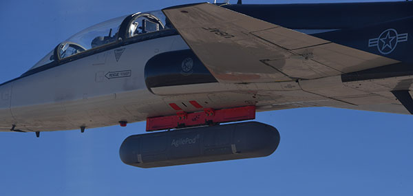
The Air Force Research Laboratory’s complementary positioning, navigation and timing (PNT) AgilePod prototype achieved three important objectives in flight tests conducted at Edwards Air Force Base Nov. 1-10, 2021.
PNT AgilePod helps develop advanced navigation technology independent of GPS, according to Maj. Andrew Cottle, Air Force Strategic Development Planning and Experimentation (SDPE) office. This technology provides reliable, resilient PNT navigation signals through alternative means, increasing mission effectiveness in scenarios where access to GPS is not guaranteed.
The test team — representing a broad base of Air Force, Navy and vendor organizations — successfully executed eight sorties aboard a T-38C aircraft, which included:
the first test of the PNT AgilePod on a high-dynamic-range platform
the first test of fully remote interfacing and alt-PNT data transmission
the first demonstration of overland/overwater transition performance.
He said the tests demonstrated the operational utility of a fused alt-PNT system incorporating multiple technologies within a single government-owned open-architecture prototype.
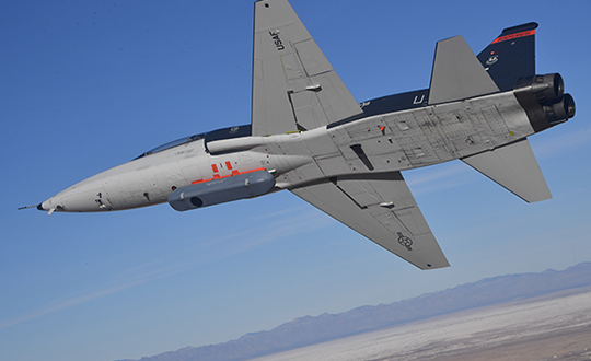
A PNT AgilePod attached to a T-38C successfully demonstrated remote interfacing and alt-PNT data transmission, as well as performance over land and water. (Photo: USAF/2nd Lt. Bowen Lin, 586th Flight Test Squadron)
AgilePods Designed for Flexibility
AgilePods are comprised of a series of compartments and can be configured to meet a wide variety of mission requirements for many aircraft platforms. Experimenters can fill the spaces with plug-and-play sensors they need for a mission — high-definition video, electro-optical and infrared sensors, and devices with other capabilities — including PNT.
The AgilePod has an open hardware architecture. For the complementary PNT prototype, it was combined with an open software architecture that allows a wide variety of alternative PNT technology to integrate and pass information. These capabilities enable rapid integration of sensor technologies through standardized software and hardware interfaces, allowing the pod to seamlessly integrate on platforms that leverage the standard architectures.
In this way, one pod can perform hundreds of different mission sets with additional benefits of cost savings and increased sustainability, Cottle said.
The project directly supports the AFRL PNT Enterprise and the Air Force PNT Cross-Functional Team as they work to ensure reliable navigation within GPS-contested operational scenarios critical to the success of future Air and Space Force missions.
A PNT AgilePod attached to a T-38C successfully demonstrated remote interfacing and alt-PNT data transmission, as well as performance over land and water. (Photo: USAF/2nd Lt. Bowen Lin, 586th Flight Test Squadron)
The NTS-3 experimental satellite will be launched in 2023, according to reports from C4ISRNET and Space News. The United States military will use the satellite for positioning, navigation and timing (PNT) as a supplement to GPS.
The satellite was originally set to launch in 2022.
The Air Force Research Laboratory (AFRL) plans to use the additional time to reduce risks and conduct more ground testing.
Navigation Technology Satellite 3 will help guide future GPS satellites, a priority area for the military as the technology has become easier to spoof and jam. Among other features, NTS-3 will have steerable beams for regional coverage and a software-defined payload that can be reprogrammed on orbit.
AFRL discussed the delay in a media roundtable held Wednesday, reports C4ISRNET. AFRL Commander Brig. Gen. Heather Pringle said that shift was out of the lab’s control since the satellite will launch as a rideshare with a U.S. Space Force payload, and that launch had been pushed back.
AFRL plans to experiment with the satellite in geosynchronous orbit for one year, testing PNT signals and architectures as well as ground-based command and control systems and software-defined radios. Following testing, NTS-3 will transition to the U.S. Space Force and integrate into the service’s other PNT capabilities.
Projects will advance technology used for secure GNSS, quantum timekeeping and communications
ColdQuanta, which specializes in cold atom quantum technology, has been awarded two development contracts from U.S. government agencies worth $2.55 million. Both projects are based on the company’s Quantum Core technology, which uses atoms cooled to a temperature of nearly absolute zero and lasers to manipulate and control the atoms with extreme precision.
Prototype Atomic Clock
The Office of the Under Secretary of Defense for Research & Engineering (OUSD R&E) awarded ColdQuanta $1.8 million for the development of a prototype atomic clock that could enable reliable, highly accurate position, navigation and timing (PNT) capabilities necessary for the functioning of critical infrastructure around the world. Atomic clocks are used for GPS/GNSS systems as well as for time-distribution services that are the basis of financial networks, computer, TV and radio services and other applications.
Alternative PNT. However, services such as satellite-based GPS can be spoofed, lack encryption or other security features, and often can’t deliver the signal strength required. Because of this, the development and deployment of a PNT system that doesn’t depend on GPS is a critical need across governments and industry, according to ColdQuanta. The company said this is especially true for mobile systems such as aircraft and spacecraft that need to know their position with great precision even when GPS is unavailable.
Under this project, ColdQuanta will deliver a state-of-the-art atomic clock with “instant on” capability if a GPS signal is lost, with a timing accuracy comparable to the best commercial clocks. It will also be ruggedized, portable and compact to enable its use in aircraft, and will minimize the power draw in between periods of demand.
“High-performance atomic clocks are the backbone of the internet, electrical power grids, financial networks, and autonomous navigation. Combining this with ColdQuanta’s development of related inertial navigation devices — such as gyroscopes, accelerometers and gravimeters — will lead to the first Quantum Positioning Systems,” said Dan Caruso, executive chairman and CEO of ColdQuanta. “We’re excited to work closely with the Department of Defense to meet their urgent needs, while also advancing the capabilities needed for future, unassailable global positioning technology.”
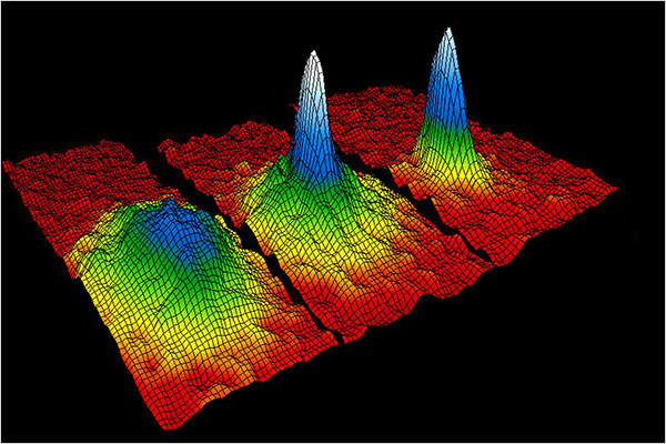
This velocity-distribution data for a gas of rubidium atoms confirmed the discovery of the Bose–Einstein condensate in 1995. In these three snapshots in time, atoms—cooled to near absolute zero—condensed from less dense areas on the left (red, yellow, and green) to very dense areas at the center and the right (blue and white). (Image: NIST/JILA/CU-Boulder)
Miniaturized Ion Trap System
Also, the Air Force Research Laboratory (AFRL) awarded ColdQuanta $750K for the development of a high-performance miniature ion trap system. Compact ion trap systems are applicable to a spectrum of quantum applications including quantum networks, computing, metrology, and timekeeping.
ColdQuanta previously developed a prototype miniaturized ion trapping system with performance that is competitive with traditional, large-footprint vacuum systems. The system maximizes performance and robustness while minimizing size, weight, and power consumption (SWaP). The new AFRL award will build on the success of this prototype to increase performance, reduce cost, and create a robust architecture for deployable quantum platforms.
Bose-Einstein Condensate
The story of ColdQuanta began in 1924 with the discovery of the Bose-Einstein condensate (BEC) — also known as the fifth form of matter — by Satyendra Bose and Albert Einstein. Seventy years later, BEC was first synthesized at the University of Colorado at Boulder in collaboration with the National Institute of Standards and Technology (NIST), for which Eric Cornell and Carl Wieman won a Nobel Prize in 2001. Their colleague, Dana Anderson, co-founded ColdQuanta, which is using the fifth form of matter as the foundation for its cold atom quantum technology.
When atoms are cooled to a few millionths of a degree above absolute zero, they take on quantum properties. Lasers are used to arrange the atoms, hold them in place, run computations on them, and read out the results. Quantum calculations, communications and sensing are the result.
ColdQuanta is collaborating with global customers including major commercial and defense companies; the U.S. Department of Defense; national laboratories operated by the Department of Energy, NASA, and NIST; major universities; and quantum-focused technology companies to advance products and services development with Cold Atom Quantum Technology. ColdQuanta is based in Boulder, with offices in Madison, Wisconsin, and Oxford, United Kingdom.
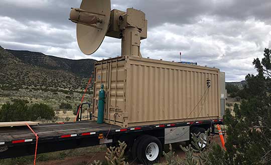
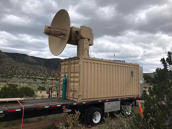
THOR stands for Tactical High-power Operational Responder, a counter-swarm electromagnetic weapon for airbase defense. Although AFRL’s THOR is not a hammer-wielding god associated with thunder and lightning, the system provides non-kinetic defeat of multiple targets. It operates from ground power and uses energy to disable drones.
The THOR drone deterrent designed by the Air Force Research Laboratory. (Photo: AFRL)
“THOR is essentially a high-powered electromagnetic source that we put together to specifically defeat drones,” said Stephen Langdon, chief of the High-Powered Microwave Technologies Branch of AFRL’s Directed Energy Directorate.
AFRL is located at Kirtland Air Force Base, New Mexico. A demonstration system has been built and tested on military test ranges near the base, where it has successfully engaged multiple targets. Further testing against a larger set of drone types in swarming configurations is being planned.
THOR stores in a 20-foot transport container, which can be transported in a C-130 aircraft. The system can be set up within three hours and has a user interface that requires little training.
The technology, which cost roughly $15 million to develop, uses high-power electromagnetics to counter electronic effect. When a target is identified, the silent weapon discharges with nearly instantaneous impact.
With much of the necessary basic research previously completed at AFRL, THOR was rapidly developed and tested in 18 months.
Although there are other drone defensive systems available, including guns, nets and laser systems, THOR will most likely to extend the engagement range to effect and decrease the engagement time over the other deterrent devices.
Langdon said the THOR team hopes to transfer the technology to a System Program Office soon in order to get it into the hands of U.S. warfighters as soon as possible.
AFRL exhibited THOR at the 2019 Air Force Association Air, Space and Cyber Conference at the Gaylord National Resort and Convention Center, located just across the Potomac River from Washington, D.C. and Virginia, Sept. 16-18.
L3Harris Technologies has reached a major milestone in the U.S. Air Force’s Navigation Technology Satellite-3 (NTS-3) project — passing the preliminary design review that defines the spacecraft’s path to delivery and allows the program to move to the next phase of development.
NTS-3 is an experimental program examining ways to improve the resiliency of the military’s positioning, navigation and timing capabilities. It will also develop key technologies relevant to the Global Positioning System (GPS) constellation, with the goal of future transition to the GPS IIIF program.
In collaboration with the Air Force Research Laboratory, Space and Missile Systems Center, and United States Space Force, L3Harris is combining experimental antennas, flexible and secure signals, increased automation, and use of commercial command and control assets.
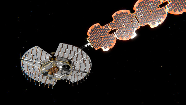
Satellite NTS-3 closeup. (Illustration: Lt. Jacob Lutz, AFRL Space Vehicles Directorate)
“The NTS-3 vanguard is an experimental, end-to-end demonstration of agile, resilient space-based positioning, navigation, and timing,” said Arlen Biersgreen, Air Force NTS-3 program manager. “It has the potential for game-changing advancements to the way the Air Force provides these critical capabilities to warfighters across the Department of Defense. The commitment demonstrated by United States Space Force to partner with AFRL and support technology transition was a key element in NTS-3 being designated as an Air Force vanguard in September 2019.”
The Space Enterprise Consortium selected L3Harris for the $84-million contract in 2018 as the prime system integrator to design, develop, integrate and test NTS-3, including ground mission applications.
“We have moved from contract award to finishing an early design review in under one year, which is an amazing accomplishment for a satellite development program that normally takes twice that amount of time,” said Ed Zoiss, President, Space and Airborne Systems, L3Harris. “We have proven we can move quickly to support the Air Force’s go-fast mission requirements.”
L3Harris has more than 40 years of experience transmitting GPS navigation signals. The company’s technology has been onboard every GPS satellite ever launched.
The U.S. Air Force will load a new signal feature, designed to make spoofing detectable, aboard a satellite that will broadcast it from space as a security overlay for the GPS L1C signal, but not until 2022 at the earliest.
The Chips Message Robust Authentication (Chimera) is now in testing under the auspices of the Air Force Research Laboratory (AFRL), getting ready to fly on the Navigation Technology Satellite 3 (NTS-3), which will trial a number of new PNT techniques and technologies.
Chimera inserts encrypted digital signatures and watermarks within the L1C signal. A GPS receiver with the requisite additional capability for this purpose can then detect whether the signal is real or fake and also authenticate the location of a GPS receiver that is remotely located.
This key feature could provide a defense against hacking by blocking access from anyone unable to prove they are at an anticipated or licensed site. Hacking, of course, is a growing threat to all sorts of infrastructure: financial, security, utility grid and more.
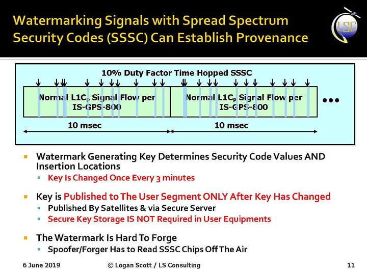
Presentation slide from PNT Advisory Board briefing by Logan Scott.
Consultant Logan Scott first proposed the Chimera technology in 2003, when he affirmed that “Some of the spoofing detection measures in wide use offer a false sense of security. Authenticatable signal architectures are needed.” In June, he made a presentation to the PNT Advisory Board: “The Role of Civil Signal Authentication in Trustable Systems.” The two slides accompanying this article appeared in that presentation.
“Chimera represents a fundamental paradigm shift in PVT security paradigms,” Scott related in a subsequent conversation. “Trust takes time and memory on a personal level and, in this case, in GNSS signals, too.
“You don’t trust somebody as soon as you meet them. Over a period of time, you get to know them. If you can’t remember anything, you can’t develop trust either.”
“In the GNSS world, there are a lot of applications where you don’t need output in real time,” Scott said. “For example, to align an inertial. The inertial provides the real-time aspect. You don’t want to send anything to the IMU that is factually incorrect. When building to aid inertial, I can afford to have a delay from real time as long as I tell it where it was 10 seconds ago. The power of that is, if I don’t have to give real-time output, I can ponder and think about things.
“If a spoofer attacks, there’s an evolution that happens there. If I, as the receiver, can see the developing scenario, and how it starts to look at little screwy, I can stop and not send anything to the IMU that might corrupt it.”
How It Works. The core concept of Chimera involves the satellites sending encrypted watermarks, encoded into the signal by the satellite. After a slight delay, the satellite sends the key used to generate those encrypted watermarks. Once a key is sent, the system changes the key.
Since the receiver has already recorded the signal with its watermarks before the key is sent, spoofers cannot know the correct key ahead of time, in time to insert correct watermarks of their own. This means that any spoofed signals can be easily spotted: either the subsequent key won’t match up with the spoofed watermarks, or there will be no watermarks at all.
“Another reason it’s hard for someone to generate these watermarks on their own is because the signal is buried below the noise,” added Scott. “The watermarks are hidden.”
A number of different time delays between signal and key are possible within this concept and within the general set-up of GPS. Scott and the AFRL have, for various practical reasons, provisionally settled on a 6-second delay on the fast watermark channel and a 3-minute delay for the slow watermark channel.
The signal enhancement could be incorporated into the Wide Area Augmentation System (WAAS). This has yet to be fully determined, but this route would lead to a faster implementation of Chimera. Scott thinks that going the WAAS route could bring Chimera capability into action within two years.
The AFRL, however, is looking at a much longer timeline. The NTS-3 satellite, where it first intends to test Chimera, will not launch until 2022 — three years hence. And that’s only a test, not an enactment or a system-wide implementation.
Slide: Logan Scott
Verification. One key benefit for commercial entities, particularly those in financial infrastructure and other systems that increasingly fall victim to hacking, is that Chimera gives them the ability to verify customers’ or partners’ locations before granting any kind of access. The customer’s or other erstwhile user’s GPS receiver would record the full signal, including the watermarks, and transmit that data to the company, entity or data center needing location verification, before the keys are published. Each combination of watermarks and signals is unique to the place where it was recorded, thus it is possible to tell whether the user is actually where they say they are, or in an authorized or pre-identified location before granting access or accepting further input (such as commands).
Scott claims that Chimera affords a 99.9% probability of detecting spoofers. “I have a 99.9% chance of detecting that the watermark is not there, because they don’t know how to generate it. This is based on how you’re processing the signal. It’s designed to be very flexible in how the receiver uses the signal.”
Just One Problem. Receiver manufacturers will have to develop new Chimera-capable receivers, and customers will have to buy them. An additional cost for the added processing, above and beyond that required for normal GPS operation, is unavoidable.
And a Hiccup. Chimera, while an acronym, is as a name perhaps not a totally felicitous choice. In Greek mythology, the chimera is a fire-breathing female monster with a lion’s head, a goat’s body, and a serpent’s tail. These historic ancestors have evolved into the word’s more current use: a thing that is hoped or wished for but that is in fact illusory or impossible to achieve.
AFRL Wants Your Opinion. The Air Force Research Laboratory seeks feedback from the PNT community on the Chimera enhancement for the L1C signal. The specification is here. And, you can download a comment form
The Ohio Unmanned Aircraft Systems Center and the Air Force Research Laboratory (AFRL) will soon begin testing groundbreaking aviation technology at the Springfield-Beckley Municipal Airport.
Ohio Governor Mike DeWine, Lt. Governor Jon Husted and Major General William Cooley, commander of the Air Force Research Laboratory (AFRL) made the announcement April 26 at Wright Patterson Air Force Base.
Skyvision was developed in a collaboration between AFRL and the State of Ohio. AFRL and a delegation of Ohio UAS industry experts will showcase the SkyVision system at AUVSI Xponential in Chicago April 30 to May 2 (Booth 4226).
The SkyVision technology safely, accurately and effectively allows drones to detect and avoid other aircraft while in flight. SkyVision can be described as an air traffic control system for drones.
Inside the Skyvision RV. (Photo: Ohio UAS Center)
The validation of this aviation technology led the FAA to grant AFRL a certificate of authorization to test defense-related drone technology without reliance on a visual observer or chase aircraft.
Typically, drones can only fly within the uninterrupted line of sight of the person operating the UAS, but this special waiver allows AFRL and the Ohio UAS Center, which is part of the Ohio Department of Transportation’s DriveOhio Initiative, to use SkyVision to test drones beyond the visual line of sight (BVLOS) within a 200-square-mile parcel of unrestricted airspace near the Springfield-Beckley Municipal Airport.
“As our country steps more and more into the unmanned age of flight, this technology is on the forefront of the aviation frontier, making Ohio a critical national asset for the research and development of UAS technology,” said Governor DeWine. “This also opens the door for commercial companies to work with Ohio, AFRL, and the FAA to test their own UAS-related
technology using our SkyVision detection system. This is a major step in revolutionizing the transportation industry, with Ohio leading the way in aerospace, defense, and aviation innovation.”
“This is an important development in the progression of unmanned aircraft,” said Major General William Cooley, Commander of AFRL at Wright-Patterson Air Force Base. “This waiver provides the latitude to test beyond-line-of-sight keeping AFRL on the leading edge of world-class research and accelerates the delivery of technology that makes a difference to the warfighter.”
“By enabling our lower-altitude airspace for advanced modes of transportation, we’ll be able to facilitate new opportunities around advanced autonomous aircraft research and development,” said Lt. Governor Husted. “This will bring investment to Ohio and solidifies Ohio’s position as a world- recognized leader in aviation technology.”
Ohio’s SkyVision detection system could potentially be used by the state to develop and test UAS technology to assist citizens in the event of a natural disaster or to significantly enhance the capability of search and rescue teams to find missing persons in time-critical situations. Commercial companies, such as those looking to use drones to survey damaged infrastructure or hoping to launch drone commerce operations, will also now have incentive to move to Ohio to test their own UAS technology.
VyrtX, a company based out of Dayton, is among the first companies that has committed to expand into Springfield to work with AFRL and the Ohio UAS Center. VyrtX is currently developing technology for the potential transport of organ donations between hospitals for transplant surgeries.
UAS test flights will take place at heights ranging from 1,000 feet above ground to 10,000 feet mean sea level. Air traffic control experts from the Ohio UAS Center will operate SkyVision during each flight. The SkyVision detection system is located within a mobile unit so that it can be flexibly placed in optimum positions for each flight.
“Today’s announcement comes after years of hard work and collaboration among an incredible group of partners,” said Jeff Hoagland, President and CEO of the Dayton Development Coalition. “AFRL and Ohio had a bold vision to bring UAS into the national airspace for true beyond-visual- line-of-sight flight. The work done here will shape the industry for years to come.”
The State of Ohio and AFRL both invested a combined $5 million for the research and development of SkyVision.
Supported by the Ohio Department of Transportation, DriveOhio works to ensure Ohio’s regulatory environment and public policies are conducive to the development of the infrastructure and technologies needed for smart mobility.
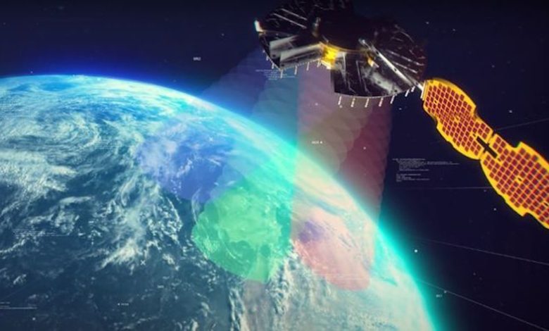
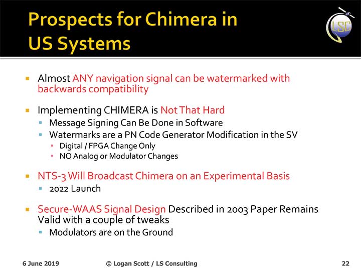
Satellite NTS-3 above Earth. (Illustration: Lt. Jacob Lutz, AFRL Space Vehicles Directorate)
Harris Corporation has been selected as the prime contractor to build Navigation Technology Satellite-3, the next-generation experimental positioning, navigation and timing (PNT) spacecraft. The satellite, called NTS-3, is expected to launch in 2022, with one year of experimental operations.
The Air Force Research Laboratory and the Space and Missile Systems Center selected Harris on Dec. 20, 2018, and announced it on Jan. 17.
PNT Testbed
As a unique testbed in geosynchronous orbit, NTS-3 will integrate several advanced technologies to demonstrate resiliency and new concepts of operation to include experimental antennas, flexible and secure signals, increased automation, and use of commercial ground assets.
Technologies matured and knowledge gained from NTS-3 are expected to transition to future generations of GPS and augmentation layers for national PNT capabilities.
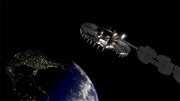
Satellite NTS-3 closeup. (Illustration: Lt. Jacob Lutz, AFRL Space Vehicles Directorate)
“The National Defense Strategy tells us we must evolve our nation’s Position, Navigation, and Timing capabilities to be more resilient,” said AFRL Space Vehicles Director Col. Eric Felt. “NTS-3 is all about resiliency, and I am incredibly excited about the resiliency experiments our SMC, AFRL, and Harris team will be able to conduct with NTS-3’s innovative and flexible hardware, software, and waveforms.”
Agile Waveform Platform
In support of NTS-3, Harris plans to develop the Agile Waveform Platform, a digital signal generator that can be reprogrammed on-orbit, enabling operators to quickly develop and deploy new signals to meet rapidly-evolving needs on the battlefield.
Additionally, Harris’ electronically steerable phase-array antenna will support simultaneous broadcast of multiple waveforms in both Earth-coverage and spot-beam configurations.
NTS-3 will use Northrop Grumman Innovation System’s ESPAStar bus, building on AFRL’s EAGLE spacecraft that launched in April 2018.
The NTS-3 Space Experiment
Navigation Technology Satellite – 3 (NTS-3) was selected as the Space Vehicle Directorate’s next major integrated space experiment in 2015, and it represents AFRL’s first PNT flight experiment to prototype a more resilient PNT multi-layer architecture in accordance with the Space Enterprise Vision (SEV) and the Space Warfighting Construct (SWC).
Satellites NTS-1, 2 and 3. (Illustration: Lt. Jacob Lutz, AFRL Space Vehicles Directorate)
NTS-3 builds on a heritage of Department of Defense (DoD) satellite navigation (SATNAV) success that began in the 1970s with the predecessors of the modern GPS constellation. NTS-1 was developed by the Naval Research Laboratory (NRL) and launched in 1974 with two rubidium-vapor frequency standards that advanced the timing and navigation precision demonstrated by the earlier TIMATION satellites.
NTS-2 launched in 1977 as the first NAVSTAR GPS Phase I satellite, and demonstrated cesium frequency standards and a worldwide network for data acquisition. There has been no major DoD SATNAV developmental program for experimentation since then, until NTS-3.
In 2017, AFRL restructured NTS-3 to emphasize mission objectives to demonstrate disaggregated, resilient PNT in a multi-layer space architecture, as outlined by the SEV and the SWC. NTS-3 will provide space qualification for core technologies such as on-orbit digital signal reprogrammability and solid-state amplifiers. In addition to new signals, onboard experiments include improvements to timing accuracy and integrity, including ensembling to improve long- and short-term stability. NTS-3 will demonstrate key tactics, techniques and procedures (TTPs) for multi-layer PNT through all three segments of the SATNAV system: space, control, and user.
Ground Control
Braxton Technologies was selected in June 2017 to handle NTS-3 SATNAV ground control, while demonstrating and maturing innovative and affordable ground-based command and control capabilities to ensure resilient PNT in contested and denied environments.
Braxton experts also will demonstrate satellite ground-control technologies to inform future GPS ground-control systems. They will use the Multi-Mission Space Operations Center (MMSOC) open architecture standard, as well as the Air Force Satellite Control Network (AFSCN) for primary direct and secure communications with the future NTS-3 space payload.
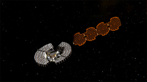
Satellite NTS-3 in space. (Illustration: Lt. Jacob Lutz, AFRL Space Vehicles Directorate)
Ground control segment (GCS) objectives include commanding of multiple antennas to form high-gain regional beams in conjunction with traditional Earth coverage beams, and processing the subsequent impact on phase center bias and pattern variation.
The GCS will also incorporate commercial antennas for TT&C and experiment with automation of common functions to reduce the level of manual control that GPS requires. GCS development will emphasize cyber security and compatibility with Enterprise Ground Services (EGS).
Collaborators Wanted
AFRL/RV is seeking collaboration from industry, government agencies, and universities in developing experimental concepts and participating in the flight experiment.
Rockwell Collins has received a 2 million contract from the Air Force Research Laboratory (AFRL) to develop and demonstrate a secure software-defined radio (SDR) GNSS receiver capability.
GNSS typically refers to equipment that can receive signals from multiple navigation satellite systems including GPS, GLONASS, Galileo, and the Chinese BeiDou system. By utilizing multiple available satellite signals, a GNSS receiver can provide improved navigation performance and signal availability.
Hosted in a software-defined radio, this AFRL program will develop the security architecture required for the receiver equipment certifications. The arrival of modernized GPS signals and other constellations is changing the way the U.S. military accomplishes GNSS-based positioning, navigation and timing.
“Rockwell Collins is actively researching GNSS capability as it applies to the U.S. and global customer base,” said John Borghese, vice president of the Rockwell Collins Advanced Technology Center. “We’re leveraging decades of GPS experience and leading edge security architectures to produce a navigation receiver that will meet global needs.”