Tag: anti-jam

  • Anti-jam technology: Demystifying the CRPA

    Controlled reception pattern antennas (CRPAs, pronounced “serpers”), adaptive antennas, null-steering antennas, beamforming antennas…

    You’ve probably heard of at least one of those terms in any discussion around GPS anti-jam technology for defense.

    Because they are all terms that describe essentially the same thing: a specialized antenna that helps protect GPS receivers from interference and jamming.

    But what exactly are they? Where did they come from? How do they work? What comes next? Read on and find out.

    A bit of history

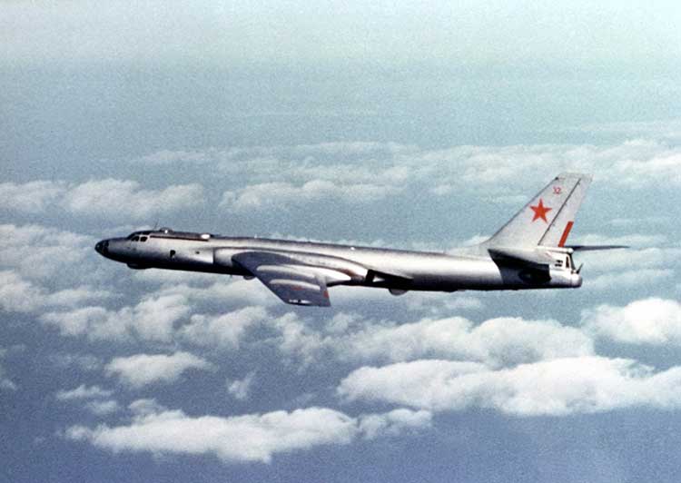
    Let’s go back to the Cold War era, at a time when Soviet and Western states were continuously battling for electronic warfare (EW) superiority. In the early to mid-Cold War, radar jamming was the name of the game. Soviet aircraft, such as the TU-16 Badger and its derivatives, carried a range of EW equipment, including some very high-power jammers designed to interfere with radar systems.

    Figure 1: TU-16 Badger, an important Soviet electronic warfare platform during the Cold War (Photo: Wikipedia)
    Figure 1: TU-16 Badger, an important Soviet electronic warfare platform during the Cold War (Photo: Wikipedia)

    Fast forward to the latter years of the Cold War, and we reach the era when the U.S. was busy developing the exciting new GPS system. The Department of Defense (DoD) wanted to ensure that a robust and accurate global navigation system was available to the military, and so the Navigation System with Timing and Ranging (NAVSTAR) launched its first satellite in 1978, eventually becoming the fully operational GPS system by 1993.

    Magnificent and ground-breaking though it was, it was recognized very early on that GPS relied on very low-power satellite transmissions, and would be vulnerable if someone tried to interfere with it. Given the prevalence of high-power jamming during the still-ongoing Cold War, there was concern that, if an adversary knew about GPS, they could easily render it useless in a given operational area.

    And so it was that the CRPA came to the rescue.

    Enter the CRPA

    Once again, this GPS anti-jam technology finds its roots in the Cold War, and specifically in radar technology, where engineers developed clever ways to ensure their radars could continue to operate in the presence of jamming. Sidelobe cancellation (SLC) was a well-established technique in the radar community, where a received jamming signal could be “cancelled” by combining the outputs of more than one antenna in the right way.

    So, it didn’t take long to adapt this radar anti-jam technology to the problem of GPS protection, and the CRPA was born. At this point I must declare a modicum of national pride, as the earliest operational GPS anti-jam unit that I know of was British. The Plessey PA 9800 GPS Anti Jam Unit was built at Roke Manor in 1984, and tested in the U.S. at the Yuma Proving Ground, Arizona, in 1985.

    This pioneering technology could defeat up to three simultaneous jammers in the shown configuration, but was modular in construction, allowing further channels to be added for handling higher numbers of jammers. And all of this in 1984, in the UK, for a U.S. military navigation system that wasn’t even fully operational yet. Incredible.

    From then until the present day, CRPAs have seen continual interest and development as the technology of choice to protect GPS from jamming. So how do they work?

    Theory of operation

    A CRPA is attractive, because it doesn’t require you to make any changes to the GPS receiver itself: It simply replaces the existing antenna. CRPAs are generally larger than typical GPS antennas, because they contain a number of antenna elements, and some associated electronics to do the clever stuff.

    There’s nothing magical or mystical about the basics of CRPAs: It’s just standard theory from your favorite textbook on adaptive signal processing. But, as ever, the devil is in the detail — how to make them work well in practice is more involved. And as the technology is generally export-controlled, I shall leave out the important in-depth details.

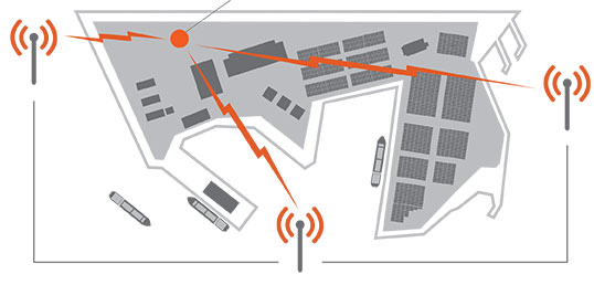
    CRPAs work by exploiting spatial diversity; that is, making use of the fact that the desired satellite signals, and the unwanted jamming signals, generally arrive from different directions. In simple terms, you create a spatial filter, one that removes signals that arrive from particular directions, whilst letting through signals from other directions. To achieve this, rather than use a single antenna, we use an array of antenna elements.

    Let’s think in simple and intuitive terms about how this works. Take a look at Figure 3. Here we have a primary antenna P, and some auxiliary antennas A1, A2, and so on. A signal arriving from the direction shown impinges on antenna A2, and slightly later it arrives at A1, and later still it arrives at P. For the sake of argument, if the signal is a simple sine wave, you will then find that the output from each antenna is that same sine wave, but with a different phase shift depending on the spatial arrangement of the antennas.

    Now, let’s consider what we call the “weights,” which are labeled as w1, w2 and so on. Each of the weights, in this case, is simply a phase shift that we can define. By careful choice of weights, we could choose to make each of the antenna outputs align perfectly in phase, and then, when we sum all the outputs together as shown, we end up with a bigger version of the input signal.

    This is what we would like to achieve if the signal was a satellite. We “steer” maximum overall antenna gain towards that satellite. This is typically what is meant when we refer to “beamforming;” It means steering maximum antenna gain towards a satellite.

    Conversely, we could also choose the weights to have the opposite effect: to minimize or completely cancel out the signal. This, of course, is what we would like to do if the signal was a jammer, and is referred to as “nulling” or “null-steering.”

    Figure 3. Adaptive antenna basics.How do we determine what those weights should be? Well, this is where your standard theory in adaptive signal processing comes in. Let’s say the objective is to minimize the jamming power out of the antenna. We can write the output power of the adaptive antenna as:

    Figure: Michael Jones
    Figure: Michael Jones


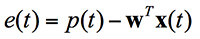
    The average output power can be found by taking expectations:

    Figure: Michael Jones
    Figure: Michael Jones


    Taking the minimum and rearranging this leads to the well-known Wiener equation:

    Figure: Michael Jones
    Figure: Michael Jones


    This Wiener equation is the one to remember. It says that the optimum weights can be found by taking the inverse of the data covariance matrix, and multiplying it by the vector of cross correlations between the primary and auxiliary antennas. As in any adaptive signal processing problem, a simple way to solve the Weiner equation and get the weights might be to use your favorite gradient descent algorithm, such as least mean squares (LMS):

    Figure: Michael Jones
    Figure: Michael Jones


    However, a solution using this approach does have its problems, for reasons beyond the scope of this article. The mathematics of beamforming are also bit more involved, so I’ll leave that out here.

    Rather than the grossly simplified diagram used here, most decent CRPAs also use a more complex architecture based on space-time adaptive processing (STAP) or space-frequency adaptive processing (SFAP). This generally allows much higher levels of jammer cancellation against a wider range of threats.

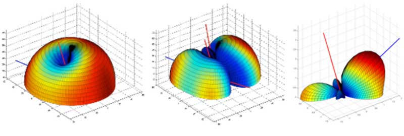
    To finish off this whirlwind section on CRPA basics, let’s see what some example antenna gain patterns might look like. In the figures below, the blue line represents the direction of arrival of a GNSS satellite signal, whilst the red lines indicate the direction of arrival of a jammer. In the first diagram we have a single jamming signal: the antenna gain pattern is a nice hemisphere, as we would generally like, but there is a nice deep null in the direction of the jammer. Moving on to the next diagram, we can see the effect of having three simultaneous jammers on the same CRPA: again we have nice deep nulls in the direction of each jammer, but we are starting to lose more of the sky, and we may start to lose the odd satellite as a consequence. Finally, we have an example of beamforming on a single satellite, whilst nulling out a jamming source.

    Again, it’s beyond the scope of this article, but the layout of the antenna elements plays an enormously important part in the performance and behavior of the CRPA.

    Figure: Michael Jones
    Figure 4. Illustrative beam patterns of a CRPA antenna in the presence of jamming. (Figure: Michael Jones)
    Figure 4: Illustrative beam patterns of a CRPA antenna in the presence of jamming (Figure: Michael Jones)
    Figure 4: Illustrative beam patterns of a CRPA antenna in the presence of jamming (Figure: Michael Jones)

    Operational Anti-Jam Units

    With some images courtesy of my friends at Raytheon, let’s look at a few examples of deployed military CRPA hardware over the years.

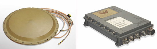
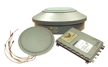
    The GAS-1 system entered service in the U.S. in 1997, as a replacement for the earlier AE-1 (1990 to 1996). The CRPA is composed of two parts: the antenna array, which is a seven-element layout, and the antenna electronics as a separate box. The GAS-1 was incredibly successful and became the de facto standard anti-jam technology, fitted to air and sea platforms around the world. Even today, 20 years after its launch, it continues to be fitted to many platforms.


    Figure 5. GAS-1 CRPA. (Credit: Raytheon)
    Figure 5. GAS-1 CRPA. (Photo: Raytheon)

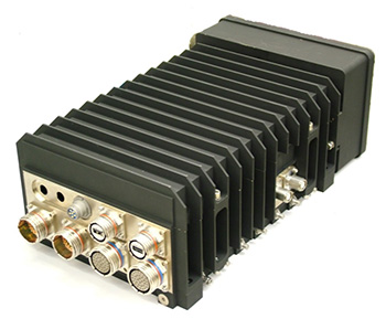
    By the late 1990s and early 2000s, the Navigation Warfare (NAVWAR) program was in full swing, and the military was looking for enhanced protection against evolving jamming threats. The U.S. initiated a program called Advanced Digital Antenna Production (ADAP). The ADAP product, launched in 2006, was a direct form-fit replacement for the analog GAS-1 system, and introduced a number of advanced features. Most notably, the ADAP simultaneously protects both the L1 and L2 frequency bands, and utilizes STAP processing to achieve high levels of wideband jammer cancellation.

    Photo: Raytheon
    Figure 6. ADAP Digital CRPA. (Photo: Raytheon)

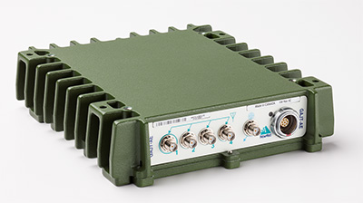
    In parallel with the ADAP development, the Digital Antenna Control Unit (DACU) was different in a number of ways. Firstly, it was a true beamforming solution, allowing simultaneous antenna beams to be steered toward satellites, whilst simultaneously nulling out jammers.

    Secondly, it was tightly integrated with the GPS receiver, with the GPS receiver hardware located in the same unit.

    Thirdly, the DACU was able to perform a number of other advanced functions, such as direction-finding of interference sources. Interestingly, the DACU was used to help locate the source of the interference at the notorious Newark airport jamming incident in 2009.

    Figure 7. DACU Beamforming CRPA. (Photo: Raytheon)
    Figure 7. DACU Beamforming CRPA. (Photo: Raytheon)

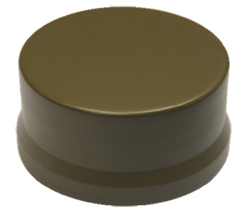
    By the mid-2000s, CRPA electronics were pretty mature and well-understood. The electronics had been miniaturized, and pretty much everything was put onto a single chip. But the physical size of the antennas persisted as a problem for some platforms requiring low size, weight and power (SWAP).

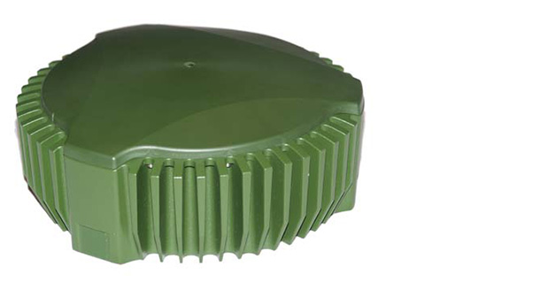
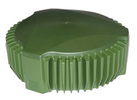
    The Landshield, launched in 2014, was a step-change in CRPA technology. Not just because it was a small and fully self-contained unit (about the size of a hockey puck), but because it was the world’s first CRPA to include true anti-spoofing capability.

    Figure 8. Landshield Advanced CRPA with Anti-Spoof Technology.
    Figure 8. Landshield Advanced CRPA with Anti-Spoof Technology. (Photo: Raytheon)

    Blurring the lines between military and civilian

    Going back a few years, the military was heavily focused on CRPAs and anti-jam techniques in general. Military GPS receivers had been developed and deployed, and the question was how they could retrofit robustness to them. At the same time, the commercial world was heavily focused on mass-market GPS receivers — reducing cost, increasing performance — with little care about jamming.

    If you’d talked to me five or six years ago, I would have said the military sector is 20 years ahead of the commercial sector in anti-jam technology, and the commercial sector is 20 years ahead of the military sector in receiver technology.

    This assertion holds far less true these days; the lines of separation are much more blurred. The military is learning from the commercial world, embracing COTS, and developing new GNSS receivers. Conversely, civilian applications are now much more concerned with jamming, leading to the adoption of low-cost CRPAs in non-military applications.

    The future of the CRPA

    Where will CRPA technology go from here? We’ve already seen that the latest generation of CRPAs now performs anti-spoofing, as well as anti-jamming. But there is plenty more to see yet.

    Although the core technology behind CRPAs is now mature, the trend for the future will be about “doing more with less.” CRPA technology will become more of a multi-function system. Military platforms need to cut down on the number of separate systems they install, and so CRPAs are likely to become multi-functional, performing situational awareness and signals intelligence.

    As antenna technology progresses, we will likely see protected navigation solutions utilizing the same hardware as communication systems and radar systems, providing CESM and RESM functions, and being part of an integrated electronic warfare suite. And conformal antennas will see a resurgence of interest for complex and space-constrained platforms.

    Watch this space.

  • Raytheon, US Air Force upgrade navigation in decoy-jammer vehicle

    Raytheon, US Air Force upgrade navigation in decoy-jammer vehicle

    Raytheon Company and the U.S. Air Force validated performance of an upgraded navigation system for the Miniature Air Launched Decoy-Jammer (MALD-J) in six flight tests from B-52 and F-16 aircraft at White Sands Missile Range, New Mexico.

    The system upgrade, designated as GAINS II (GPS-Aided Inertial Navigation System), includes an enhanced multi-element GPS-controlled antenna assembly. The new technology improves MALD-J navigation performance in a GPS jamming environment. Improvements and efficiencies within the design helped to reduce GAINS II unit costs.

    “Improving performance while reducing costs is a win for Raytheon and our customer,” said Brian Burton, director of MALD Programs for Raytheon.

    Raytheon Space and Airborne Systems in El Segundo, California, supported design work for GAINS II, while Raytheon Missile Systems in Tucson, Arizona, supplied systems engineering, integration and testing. Raytheon is now producing and delivering MALD-J systems with the upgraded navigation.

    About MALD and MALD-J

    MALD is a state-of-the-art, low-cost expendable flight vehicle that is modular, air-launched and programmable. It weighs fewer than 300 pounds and has a range of approximately 500 nautical miles. MALD-J adds radar-jamming capability to the basic MALD platform.

    MALD confuses enemy air defenses by duplicating friendly aircraft flight profiles and radar signatures.

    MALD-J maintains all capabilities of MALD and adds jamming capabilities.

  • New system designed to protect avionics from GPS jamming

    New system designed to protect avionics from GPS jamming

    Israel Aerospace Industries (IAI) has unveiled ADA — an advanced system that protects avionic systems from GPS jamming.

    ADA has already been integrated into several systems and platforms operating both in Israel and abroad. The system recently won a tender from Israel’s Ministry of Defense for integration into one of the main platforms of the Israel Air Force.

    ADA was developed by IAI’s MALAM division, a national center of excellence for anti-jamming protection of GNSS receivers.

    Anti-GPS jamming system (ADA) by Israel Aerospace Industries.
    Anti-GPS jamming system (ADA) by Israel Aerospace Industries. Photo: Israel Aerospace Industries

    Under the terms of the project with the Israeli Air Force, IAI will deliver a turnkey solution based on its multi-channel Controlled Reception Pattern Antenna (CRPA) technology.

    The ADA integration will ensure the operational continuity of the aircraft fleet, allowing avionic systems which rely on satellite navigation systems to continue uninterrupted operation even under direct electronic attack, when the enemy uses GPS jammers or other methods of interference.

    “We are excited to receive this important contract, it is a great compliment for IAI,” said Jacob Galifat, general manager of the IAI MALAM division, “Facing today’s threats to GNSS, these systems are a must, for any platform using GPS, or any other global satellite navigation systems. Our operationally proven systems will ensure the availability of GPS- and GNSS-based systems, even in the most contested, EW-saturated battle space. Considering the operational challenges, we believe this system has considerable export potential for many air forces and armies who experience GNSS jamming in combat zones.”

    The ADA system was successfully evaluated recently in the United States, at the NAVFEST event, where foreign military forces contest anti-jamming systems against various electronic-warfare challenges.


    Modern navigation, communications and intelligence collection and electronic warfare systems integrated in modern platforms rely on the uninterrupted availability of satellite-based navigation and timing for their operation. Despite this dependency, most platforms do not use electronic counter countermeasures (ECCM) systems to protect those essential assets. Remaining exposed, even low-power jammers can disrupt or even deny the operation of GNSS systems, thus degrading the platform’s capability to fulfill its mission.

    Based on an advanced electronic architecture and the implementation of sophisticated digital processing, the agile ADA system, developed by IAI MLM, protects a broad range of GNSS systems operating on manned and unmanned combat aircraft and helicopters. ADA variants are also used in land-based platforms such as main battle tanks and APCs, and on naval systems. Other derivatives of the system are integrated in various guided weapons.

    The ADA system will be displayed at the Aero- India exhibition in Bangalore, India, Feb. 14-18, 2017 (Hall A, Booth A1.1a).

  • Mayflower selected for submarine antenna anti-jam upgrade

    Mayflower selected for submarine antenna anti-jam upgrade

    An antenna upgrade for U.S. Navy submarines is being provided to improve GPS anti-jamming capabilities.

    Mayflower Communications Company, subcontractor to Lockheed Martin Sippican, is applying its Submarine Anti-Jam GPS Enhancement (SAGE) capability to the U.S. Navy Multifunction Mast Antenna System (OE-538B) upgrade to improve submarine communications and meet Navigation Warfare (NAVWAR) requirements.

    The SAGE (NavGuard 501) GPS anti-jam unit.
    The SAGE (NavGuard 501) GPS anti-jam unit.

    The Mayflower SAGE — a variant of Small Antenna System (SAS) — was developed specifically for inclusion on Submarine Platforms to support U.S. Navy requirements for GPS anti-jam.

    The SAGE’s small size and feature set make it capable for ease of integration by Lockheed Martin Sippican into the OE-538B antenna mast.

    The SAGE is a high performance and low size, weight and power (SWaP) cost-effective antenna system that will enable the U.S. Navy submarine fleet to operate in GPS contested or denied (NAVWAR) environments.

    The SAGE (NavGuard 501) can supply clean GPS Signals to multiple GPS receivers from a single antenna and is compatible with C/A, SAASM P(Y), and M-code receivers. The SAGE fits he small SWaP requirements of the OE-538B antenna mast.

    The SAGE is Mayflower’s latest federated, affordable anti-jam solution that leverages proven small antenna system (SAS) technology and provides Iridium capability in an integrated antenna. The SAS solution has been extensively tested by the federal government on multiple platforms.

    The SAGE is the highest performance and smallest GPS anti-jam federated solution with Iridium capability in the market. The SAGE AJ solution offers an affordable SWaP-C alternative over larger and more expensive existing anti-jam systems.

    The Space and Naval Warfare Systems Command (SPAWAR HQ) awarded the sole source contract for the development of an OE-538B antenna upgrade and procurement to Lockheed Martin Sippican/Granite State Manufacturing Submarine Antenna Joint Venture. The contract is in support of the Program Executive Office for Command, Control, Communications, Computers, and Intelligence (PEO C4I), Undersea Integration Program Office (PMW/A 770).

    Mayflower was selected by the U.S. Navy and Lockheed Martin Sippican to design, develop, and integrate the Submarine Anti-Jam GPS Enhancement (SAGE) (NavGuard 501) product.

    Joseph Thomas, Mayflower’s Director of Government Programs, said, “The SAGE product has given Mayflower the opportunity to support a U.S. Navy National Strategic Level Platform and to expand into the next generation of small SWaP NAVWAR GPS Anti-Jam systems. The SAGE ensures we can continue to offer the warfighters the very latest and most efficient technology to support operations in an A2AD Environment”.

    Mayflower is working closely with Lockheed Martin Sippican to complete integration and environmental qualification of the SAGE to support the OE-538B program requirements.

  • US Naval Observatory chooses NovAtel GPS anti-jam technology

    US Naval Observatory chooses NovAtel GPS anti-jam technology

    The GAJT by NovAtel.
    The GAJT by NovAtel.

    The United States Naval Observatory (USNO) has selected NovAtel’s GPS Anti-Jam Technology (GAJT) to satisfy a requirement for a controlled reception pattern antenna capability at sites throughout the Department of Defense Information Network (DoDIN).

    The DoDIN is the core global enterprise network of the United States military and is depended upon for secure and sensitive voice, data, video and bandwidth services. This latest order brings the number of NovAtel GAJT antennas ordered by the U.S. Navy to more than 600.

    GAJT protects GPS-based navigation and precise timing receivers from intentional jamming and accidental interference. It is a null-forming antenna system that ensures satellite signals necessary to compute position and time are always available.

    The commercial off-the-shelf product comes in versions suitable for land, sea, fixed installations and smaller platforms such as UAVs. Military vehicles and platforms, networks and timing infrastructure also benefit from the protection that GAJT provides. There is no need to replace GPS receivers already installed, as GAJT works with civil and military receivers, and is ready for M-code, according to NovAtel.

    NovAtel’s manufacturing techniques and quality processes mean that that the company can ramp up quickly to meet volume requirements, the company said.

    “This order underlines our ability to deliver GAJT in volume and on time,” said Michael Ritter, president and CEO of the Canada-based NovAtel. “GAJT has now been shipped and is in use operationally by 12 allied nations around the globe. We are grateful for the rigorous technology selection process conducted by USNO which led to this latest order.”

    The U.S. Naval Observatory is located in Washington, D.C.
    The U.S. Naval Observatory is located in Washington, D.C.

    Located in Washington, D.C., the USNO is one of the oldest scientific agencies in the United States, with a primary mission to produce Positioning, Navigation and Timing for the United States Navy and the United States Department of Defense.

  • Canadian Army to Test NovAtel GPS Anti-Jam Antenna

    Canadian Army to Test NovAtel GPS Anti-Jam Antenna

    NovAtel's GAJT-AE GPS anti-jam antenna.
    NovAtel’s GAJT-AE GPS anti-jam antenna.

    Public Works and Government Services Canada (PWGSC) has selected NovAtel’s GAJT-AE antenna electronics for testing on Canadian Army platforms. The GAJT-AE, developed in Calgary at NovAtel’s global headquarters, is a GPS anti-jam solution suitable for small and weight constrained applications. The testing is being conducted through PWGSC’s Build in Canada Innovation Program (BCIP).

    PWGSC will procure a number of GAJT-AE’s on behalf of the Department of National Defence (DND). The Director Land Requirements (DLR), with the assistance of the Quality Engineering Test Establishment (QETE), will oversee all testing on DND’s behalf. Field testing is expected to take place in the latter half of 2015 at 4th Canadian Division Support Garrison Petawawa.

    The testing will analyze the performance of GAJT-AE on Canadian Army equipment in operational conditions to confirm the suitability and robustness of the NovAtel technology for this role. The process is expected to be completed by the end of March 2016.

    GAJT is a null-forming technology that negates jammers, ensuring the satellite signals necessary to compute position and time are always available. Three categories of GAJT are manufactured by NovAtel:

    • GAJT-710ML: for use with military land vehicles, networks and timing infrastructure
    • GAJT-710MS: for marine vessels, from small boats to capital ships
    • GAJT-AE: for use with an external antenna in size and weight constrained applications

    “NovAtel has had great success working closely with the Canadian Army on the previous round of BCIP,” said Jason Hamilton, NovAtel’s vice president of marketing. “It is essential to have military users test our products in operational scenarios. We look forward to the valuable feedback that the Canadian Army testing of GAJT-AE GPS anti-jam antenna electronics will provide. NovAtel will use this feedback to continue developing products in support of Canada and its Allied partners.”

    The BCIP was created by the Government of Canada to strengthen Canadian innovation. The program offers procurement and testing of pre-commercialized products and services, at a late stage of development. The BCIP:

    • Bridges the “pre-commercialization gap”
    • Supports Canadian suppliers by connecting innovators and government users and by testing innovations
    • Provides real-world evaluation of pre-commercial goods and services
    • Improves the efficiency and effectiveness of government operations.
  • Chemring Develops Miniaturized GPS/Galileo Anti-Jamming Technology

    2014-gincan

    Chemring Technology Solutions has developed miniaturized GPS anti-jamming technology it has dubbed GINCANGINCAN is designed to combat illegal GPS jammers and is based on the adaptive antenna concept used by military systems. GINCAN has a chip footprint of six millimeters squared.

    GINCAN’s reduced size and weight will significantly cut power usage and cost, the company said, making it ideal for combatting the widespread problem of low-powered GPS jamming. GINCAN can be integrated into a range of applications, including in-vehicle satellite navigation systems and cellular technology, and can be used for the protection of the critical infrastructures which rely on GPS to provide positioning and timing.

    GPS jammers have already been developed to interfere with the European Union’s Galileo system, which will provide European satellite navigation independently from the Russian, USA and Chinese systems by 2019. Chemring Technology Solutions, based in Romsey, England, has anticipated this problem and its GPS anti-jamming technology will also support systems using Galileo.

    Once the preserve of the military, there is now an increasing demand for GPS protection in the civilian market as illegal GPS jamming equipment becomes widely available on the Internet. The £1.5 million government-funded Sentinel project, designed to measure GPS jamming on UK roads, recorded more than 60 individual jamming incidents across six months at a single location. Such attacks could seriously impact industries, including maritime, aerospace, the emergency services and even stock market trading.

    “Many years of developing GPS protection technology for the military has enabled our research and development team to miniaturize anti-jamming technology,” said Martin Ward, product manager, Chemring Technology Solutions. “GINCAN can now be easily integrated in to a range of applications to provide effective protection against jamming devices.

    “As we become increasingly reliant on GPS technology, and low-cost jammers are proliferating, so a potential time bomb is being created. Chemring Technology Solutions is now able to offer the answer to this problem with jammer protection at a reduced size, weight, power and cost footprint.”

    GINCAN is an export controlled product and subject to UK export restrictions.

  • Applied EM Offers Anti-Jam Antenna

    Applied EM’s anti-jam GPS antenna, AJGPS045, has achieved a four-channel Controlled Radiation Pattern Antenna (CRPA) in a very small size, weight and power (SWAP) particularly suitable for airborne platforms. Its footprint is the same as a standard GPS Fixed Radiation Pattern Antenna (FRPA), the FRPA-3.

    This is a key enabler to bringing greatly improved anti-jam performance to smaller platforms and to GPS-equipped platforms that have inadequate anti-jam capability.

    When integrated with appropriate four-channel antenna electronics and a military GPS receiver, the AJGPS045 enables L1 and L2 anti-jam performance of typically >80 dB. This is achieved with a passive compact antenna (.7” x 4.6” x 4.6”) that weighs 9 oz.

  • Canadian Army to Test NovAtel’s GAJT GPS Anti-Jam Antenna

    Canadian Army to Test NovAtel’s GAJT GPS Anti-Jam Antenna

    NovAtel-GAJT_antenna
    NovAtel’s GAJT-700ML anti-jamming antenna.

    Public Works and Government Services Canada (PWGSC) has selected NovAtel’s GAJT-700ML antenna for testing on Canadian Army armored vehicles. The GAJT-700ML, developed in Calgary at NovAtel’s global headquarters, is a single-unit GPS anti-jam antenna system for land vehicles.

    The testing is being conducted through PWGSC’s Build in Canada Innovation Program (BCIP).

    NovAtel was selected to participate under the BCIP’s “safety and security” priority area. PWGSC will procure a number of GAJT-700MLs on behalf of the Department of National Defense (DND). The Directorate of Land Requirements (DLR) — with the assistance of the Quality Engineering Test Establishment (QETE) and the Land Force Trials and Evaluation Unit (LFTEU) — will oversee all testing on DND’s behalf.

    Field testing, centered on battlefield days, is expected to take place in early March of 2014 at 4th Canadian Division Support Garrison Petawawa. The battlefield days will analyze the performance of GAJT on the Artillery Observation Post Variants (OPV) of the Light Armored Vehicle III (LAV III) in operational conditions to confirm the suitability and robustness of GAJT-700ML for this role. The process is expected to be completed by the end of March.

    “NovAtel has worked closely with Canadian and Allied defence agencies to test the resilience of the GAJT-700ML in challenging jamming environments,” said Jason Hamilton, vice president, Marketing and Product Management. “The BCIP program provides an opportunity to expand this testing to incorporate end user soldier feedback on the installation and operational effectiveness of GAJT during battlefield usage of the LAV OPV. This invaluable feedback will be used by NovAtel to further drive product innovation in support of Canada and its Allied partners.”

    “The Canadian Army requires accurate, secure and reliable access to Global Positioning Systems to conduct operations throughout the full spectrum of conflict in all potential theatres of operation,” said Colonel Andrew Jayne, Director Land Requirements. “With the ever-increasing demands on the electromagnetic spectrum and threat of harmful interference, technologies which contribute to the assurance of position and timing information are a critical enabler of Army and Canadian Armed Forces operations in today and tomorrow’s operating environment.”

    GAJT is a null-forming technology that negates jammers, ensuring the satellite signals necessary to compute position and time are always available. Three categories of GAJT are manufactured by NovAtel:

    • GAJT-700ML: for use with military land vehicles, networks and timing infrastructure
    • GAJT-700MS: for marine vessels, from small boats to capital ships
    • GAJT-AE: for use with an external antenna in size and weight constrained applications

    The BCIP was created by the Government of Canada to strengthen Canadian innovation. The program offers procurement and testing of pre-commercialized products and services, at a late stage of development. The BCIP:

    • Bridges the “pre-commercialization gap”
    • Supports Canadian suppliers by connecting innovators and government users and by testing innovations
    • Provides real-world evaluation of pre-commercial goods and services
    • Improves the efficiency and effectiveness of government operations
  • Spirent Demonstrates Solution That Helps Reduce GNSS Vulnerability

    Spirent Demonstrates Solution That Helps Reduce GNSS Vulnerability

    Spirent-Qascom

    Spirent Communications, a navigation and positioning systems testing company, has teamed up with Qascom, an expert in GNSS signal security and authentication, to develop a test tool that reproduces spoofing attacks in a controlled laboratory environment.

    The collaborative solution will be launched commercially later in 2013, and was previewed at ION GNSS+ in September in Nashville, Tennessee.

    The test bed will concurrently simulate legitimate GNSS constellations and spoofed or hoax signals. It will enable positioning systems manufacturers to improve their products’ resilience to hoax signals.

    As GNSS becomes increasingly embedded in modern infrastructure for application timing and device positioning, the impact of spoofing attacks becomes greater. From mobile telephony to Internet banking, GNSS timing signals are used in many key systems, and yet there is no requirement on GNSS equipment to demonstrate any degree of robustness to block or even detect malicious attacks that disrupt performance.

    “There is growing industry concern about the vulnerability of satellite navigation signals,” said John Pottle, Marketing Director of Spirent’s Positioning Division. “This will help the industry to create positioning systems that are more resilient to interference.”

    Hoax or spoofing attacks work by mimicking genuine GNSS signals, which mislead GNSS receivers. Often affected receivers do not recognize when they are receiving fake signals and continue to operate normally, but provide false time or position information. This new test tool helps to develop systems that will detect and counter spoofing attacks by providing a fully controllable laboratory based, non-radiated test solution to evaluate a receiver’s response to a range of spoofing attacks. The test tool controls the emulation of signals representing both the genuine GNSS signals and the false signals. This allows users to simulate a wide range of sophisticated attacks and monitor the response of the receiver under attack to then improve the resilience of the design against such attacks.

    For more information on threat detection and mitigation testing visit Spirent Booth #F during ION GNSS+, September 15-20 in Nashville, Tennessee.

  • Exelis Signal Sentry Test Locates GPS Jamming Threats

    The Signal Sentry 1000.
    The Signal Sentry 1000.

    Signal Sentry 1000, an Exelis product that detects and locates GPS interference sources in 3-D by using longitude, latitude and altitude has demonstrated successful results during a planned field testing event held last week at the Vidsel Test Range in Sweden.

    Taking advantage of the range’s remote location, Exelis was able to conduct tests of its Signal Sentry 1000 product using controlled jamming. The test was conducted without disrupting the GPS signal relied upon by civilian and military operations outside of the test range location. The test employed eight sensors positioned in an array pattern and showed that Signal Sentry was able to successfully detect and locate the jamming source. Having demonstrating interference detection and location capability, Signal Sentry 1000 can be deployed to collect actionable intelligence for law enforcement and protect GPS signal-dependent critical infrastructures.

    Signal Sentry 1000 technology is a network of threat-detection sensors, which is part of a centralized server executing Exelis-developed proprietary location algorithms. These sensors can be strategically located around different types of critical infrastructure, such as shipping ports, utilities and government facilities to automatically sense and locate any intentional or unintentional GPS jamming source. Should a threat be detected, users would receive location information and actionable intelligence in order to determine an interference-mitigation plan.

    “Exelis developed Signal Sentry 1000 to help protect critical infrastructure and to deliver intelligence to law enforcement operations that depend upon GPS availability,” said Mark Pisani, vice president and general manager of precision instruments and positioning, navigation and timing for Exelis Geospatial Systems. “Achieving this field test milestone proves that our detection technology works. The next step is to evolve this technology for our military customers.”

    Signal Sentry 1000 builds upon Exelis expertise in the field of GPS and positioning, navigation and timing. Exelis payloads and payload components have been on board every GPS satellite for nearly 40 years. Today, Exelis is involved in GPS modernization initiatives, building tomorrow’s GPS III satellite constellation by developing and integrating the navigation payloads. Exelis is also providing navigation processing components, precision monitor station receivers, and key components of the system security design for the GPS Operational Control System, known as OCX.

  • Chronos Technology to Exhibit Anti-Jam Tech at ION GNSS+

    Chronos Technology, global timing and synchronization company, is exhibiting its anti-jamming technology at ION GNSS+ 2013 in Nashville, Tennessee, September 18-20.

    Exhibiting at Stand 723, Chronos will be demonstrating the Chronos Sentinel system, which enables a light-touch deployment of GPS jamming detection for a short period of time and allows a GPS jamming report to be created to enable management to assess the threat.

    The CTL3520 handheld GPS jamming detector by Chronos Technology.
    The CTL3520 handheld GPS jamming detector by Chronos Technology.

    Chronos will also be displaying various GPS products, including the new CTL3520 handheld GPS jamming detector and locator system aimed specifically at detecting GPS jammers hidden in vehicles.  The unit can pinpoint even the weakest jammer and identify the vehicle in which the jammer is hidden, even in a busy multi-storey car park. Other applications include detecting vehicles with jammers at ports, fleet depots, airport car parks and taxi ranks.

    In addition, Professor Charles Curry, managing director with Chronos Technology, is presenting a technical paper “GPS Jamming -Threat Scenarios” on Monday, September 16, at CGSIC, which precedes ION GNSS+ 2013.

    For more information about ION GNSS+ 2013, visit www.ion.org