Apogee has been awarded a five-year, $103 million task order to provide positioning, navigation and timing (PNT) support services for the U.S. Department of Defense.
The contract supports modernization, acquisition and sustainment planning across the international PNT enterprise, ensuring resilient and reliable capabilities that underpin critical military operations worldwide.
Under the contract, Apogee will deliver technical expertise and mission support across multiple locations, including Robins Air Force Base, Georgia; Wright-Patterson Air Force Base, Ohio; and Eglin Air Force Base, Florida.
Apogee’s team will contribute to advancing next-generation PNT capabilities, strengthening system performance and supporting the continued evolution of a mission essential to joint and coalition operations.
Apogee is headquartered in Colorado Springs, Colorado, with regional offices nationwide.
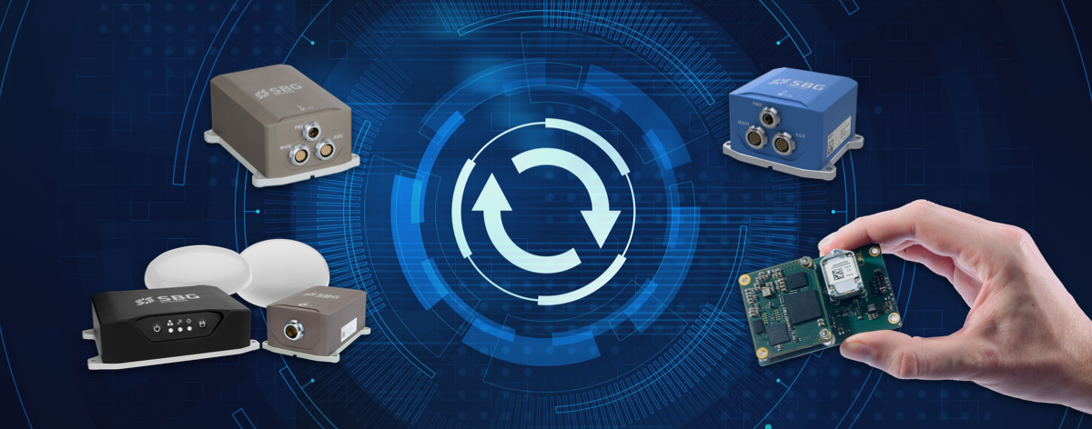
SBG Systems has released a major firmware update for all its high-performance inertial navigation systems (INS), including its Ekinox, Apogee, Navsight and Quanta brand sensors.
Developed in collaboration with customers, firmware 4.0 provides new features and is designed to make integration easier for system designers. It aims to provide improvements in these areas:
System accuracy and robustness
Enhanced heading in a single antenna allows for easier UAV survey operations.
Improved GNSS antenna auto lever arm calibration provides a faster and easier system setup.
Easier system integration
New PTP and NTP features for time synchronization eliminate the need and cost of an external timing module.
An integrated NTRIP client eases access to NRTK/VRS correction services.
A logged RTCM raw stream eases post-processing in SBG Systems’ post-processing software Qinertia using the user’s NRTK/VRS data.
A new Access Rights Management System sets up specific user roles.
Two serial outputs have been added on Navsight and Quanta for advanced survey setups.
REST API has been introduced for power users and integrators.
Shom, the French national hydrographic and oceanographic office, selected SBG Systems’ inertial navigation systems to renew its fleet.
The office chose the Navsight Apogee inertial navigation systems (INS) for its speedboats and survey vessels for both shallow and deep-water real-time bathymetric surveys and Qinertia PPK software for post-processing tasks.
As a public institution, Shom (Service hydrographique et océanographique de la marine) has three major objectives: national hydrography and cartography, defense support in hydro-oceanographic fields, and support in maritime geospatial products and services for public policies on the sea and the coast.
Shom’s fleet is based in Brest. It is composed of eleven boats, including seven speedboats, and three 59-meter long BH2 survey vessels. They operate on shallow and deep water in France, Africa, the Indian Ocean and in the Caribbean Sea. Shom also uses a fleet based in New Caledonia composed of two boats, one speedboat and a buoy-laying vessel used part of the time for hydrographic surveys.
French agency Shom’s survey vessel. (Photo: Shom)
Renewing the fleet. When it came to renewing the fleet’s INS, Shom looked at INS complying with standards set by the International Hydrographic Organization (IHO) for bathymetric surveys, with a focus on roll and heave that have the biggest impact on the multibeam echo-sounder data compensation.
After having conducted several tests in their official test zone where each element’s location is strictly and precisely known, Shom selected SBG Systems for replacement of its INS.
Shom first acquired a Navsight Ekinox (0.02° roll) for shallow-water survey in New Caledonia, and then decided to outfit the fleet in Brest with the Apogee (0.008° roll).
“The BH2 is highly versatile; it fits both deep and shallow water requirements. Having a homogenized fleet of sensors for speedboats and the BH2 is easier to maintain,” said Rémi Labonde, who is in charge of positioning and hydrographic equipment at Shom.
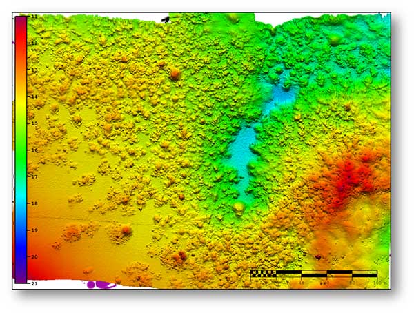
A seafloor survey conducted by Shom. (Image: Shom)
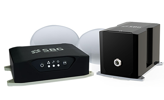
Navsight Apogee INS
Designed for hydrographers, the Navsight Apogee is composed of a GNSS receiver and a processing unit enabling real-time fusion of inertial and navigation data.
Navsight provides connections to external equipment such as echo sounders and computers. With its titanium enclosure, the Apogee sensor can be installed in the floodable engine compartment, close to the multibeam echo sounder.
Navsight marine solution. (Photo: SBG Systems)
Navsight Apogee is a high-performance cost-effective inertial navigation system based on state-of-the-art micro-electrical mechanical (MEMS) technology, and therefore requires no annual maintenance. The SBG solution includes free unlimited firmware updates and technical support.
Once connected through Ethernet, the Navsight web interface guides the installation. For example, a 3D view of the boat shows the entered parameters so that the user can check the installation in real-time.
The embedded filter also controls and validates lever arms and antenna alignment during this procedure, which can be a plus if the Shom needs to calibrate a new system abroad. “We are big fans of SBG’s web interface. It is modern, extremely clear, and easy to use; it really makes a difference in our team’s work,” Labonde said.
Qinertia post-processing software. Navsight Apogee INS accepts real-time corrections from real-time kinematic (RTK) or precise point positioning (PPP).
In its daily surveys, Shom uses PPP positioning, which doesn’t require installation compared to RTK. It also allows offshore surveying, or even near shore when no RTK correction is available.
SBG Systems’ in-house post-processing software Qinertia fixes data issues due to communication cut-outs. The onboard team checks the data and corrects it with Qinertia if needed.
SBG Systems has released the Horizon IMU, a FOG-based high performance inertial measurement unit (IMU) designed for highly demanding surveying applications such as high-altitude data collection or mobile mapping in dense areas such as urban canyons.
SBG Systems made the announcement at the International LiDAR Mapping Forum (ILMF) in Denver.
The Horizon IMU joins the Ekinox and Apogee IMUs as options for the Navsight Land/Air Solution. The solution consists of a powerful and ready-to-use inertial navigation solution dedicated to surveyors for mobile data collection.
The new Horizon IMU allows customers to bring the Navsight technology to the most demanding environments such as high-altitude surveying and highly dense areas, as well as application where only a single antenna can be used.
The different levels of accuracy enable the solution to meet various application requirements and can be connected to various external equipment such as odometer, lidar and more. The Ekinox and Apogee MEMS-based IMUs address most surveying markets for camera or lidar motion compensation and data geo-referencing.
The Horizon IMU is based on a closed-loop FOG technology which enables ultra-low bias and noise levels. This technology allows robust and consistent performance even in low dynamics survey.
The Navsight solution is easy to install in a vehicle — the sensor alignment and lever arms are automatically estimated and validated. Once connected to the Navsight processing unit, the web interface guides the user to configure the solution.
A 3D view of the vehicle shows the entered parameters so that the user can check the installation. By choosing the vehicle — a plane or a car, for example — the inner algorithms are automatically adjusted to the application.
The Navsight unit also integrates LED indicators for satellite availability, real-time kinematic (RTK) corrections and power.
Full INS/GNSS Post-Processing Software
Completing the Navsight offer, Qinertia, the SBG post-processing software, gives access to offline RTK corrections from more than 7,000 base stations in 164 countries. The software delivers the highest level of accuracy without having to set up a base station. Trajectory and orientation are then greatly improved by processing inertial data and raw GNSS observables in forward and backward directions.
Navsight is ITAR-free. All models are available for order. Ordering information and delivery time are available from SBG Systems representatives and authorized SBG Systems dealers.
SBG Systems, a manufacturer of inertial navigation systems (INS), has selected the Septentrio AsteRx4 OEM GNSS receiver to equip its Apogee product line. The announcement was made during Ocean Business 2015, held April 14-16 in Southampton, England.
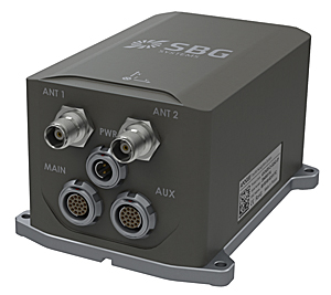
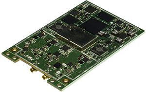
SBG Systems’ Apogee-D
“We are delighted that SBG Systems — a respected specialist in designing INS/GNSS — endorses our newly released GNSS receiver for its performance,” said, Laurent Le Thuaut, business development manager at Septentrio. “The SBG products are recognized amongst the preferred choice for accurate MEMS-based INS and we are extremely proud that our technology is included in their top of the line.”
Apogee is a new product line of high-accuracy inertial navigation systems based on robust and cost-effective MEMS technology. The INS/GNSS solution combines the latest generation of MEMS sensors and the OEM version of the AsteRx4, a newly introduced high-precision GNSS receiver from Septentrio. The Apogee series is especially suited for applications such as hydrography, mobile mapping and aerial survey where survey-grade positioning measurements are required.
AsteRx4 OEM
The AsteRx4 OEM is a multi-frequency and multi-constellation dual antenna receiver that incorporates the latest innovative GNSS tracking and positioning algorithms from Septentrio. The AsteRx4 is scalable to one centimeter and integrates the entire suite of GNSS+ algorithms proposed by Septentrio to maintain tracking during heavy vibration of machines. This assures position accuracy under difficult ionosphere conditions and mitigates or rejects intentional or unintentional interference with GNSS signals.
“The compact design and the practical and well-designed interface of the AsteRx4 allowed a seamless and an easy integration into our solutions” said Raphaël Siryani, chief marketing & sales officer of SBG Systems. “The AsteRx4 largely contributes to the robust and accurate heading as well as the reduced power consumption of the INS/GNSS Apogee products.”
Both the AsteRx4 OEM receiver and the Apogee INS/GNSS are on display at booth No. W40 (Septentrio) and booth E5c (SBG Systems) at Ocean Business.
SBG Systems has released the Apogee Series, its most accurate inertial navigation systems based on robust and cost-effective MEMS technology. The INS/GNSS integrates the latest generation of MEMS sensors and a tri-frequency GNSS receiver. Apogee achieves 0.008° in roll and pitch in real-time and 0.005° in post-processing. With two antennas, it delivers a robust and accurate heading.
Four models compose the Apogee line.
The Apogee-A provides only orientation data.
The Apogee-N additionally embeds a GNSS receiver; it is a compact solution with one antenna for land and aerial applications.
The Apogee-D embeds a dual-antenna GNSS receiver for accurate heading under low dynamics conditions.
The Apogee-E delivers navigation data when connected to an external GNSS receiver or to the SplitBox with integrated GNSS.
Mobile Mapping. Apogee can be precisely synchronized with LiDAR equipment because of a UTC time-stamping accurate to 1 microsecond. This integrated INS/GNSS provides optimal position in multipath environment or during GNSS outages, thanks to a tight GNSS integration and the continuous fusion of inertial and odometer data. To get the required positioning accuracy, Apogee supports RTK and Precise Point Positioning services (Omnistar, Terrastar, and more).
Aerial Mapping and Remote Sensing. With very low noise gyroscopes, low latency, and high resistance to vibrations, the Apogee allows aerial surveys by plane or helicopter. It provides real-time orientation and position data with direct fusion of inertial and GNSS information. Compact, lightweight and low power, the Apogee is easy to install, and has an embedded web interface for configuration.
Post-processing. Orientation and position data can be recorded in the Apogee data logger. At the office, the user imports data in the post-processing software. This tool gives access to several RTK networks and reference station offline data (such as VRS and CORS.) Additionally, it enhances orientation and position accuracy by a complete “backward/forward” calculation.
“SBG Systems manufactures inertial systems from the concept to the production. The Apogee benefits from our high level of expertise in integrated design, IMU calibration, testing, and filtering,” said Alexis Guinamard, CTO of SBG Systems.
All models are available for order. Below is a promotional video with more information.
Apogee Mapping has released amLibrary, a spatial data bundle that includes the company’s four flagship products and is packaged exclusively for use by higher education institutions.
The bundle includes Apogee’s amElevation, amHillshade, amContour, and amWater. AmElevation is a national dataset of 1-arc second digital elevation data (DEM); amHillshade comprises nationwide 40, 200, and 1,000 foot contours in a smoothed vector format; amHillshade is a national set of tiled raster topography offered in both grayscale and full-color; and amWater is a premium vector hydrography dataset derived from information generated by the U.S. Environmental Protection Agency. AmLibrary also includes 50 data layers depicting environmental, climactic, and geologic data. Bundled together, this information provides GIS users with comprehensive and detailed terrain data that can be used as a basis upon which to conduct research and perform complex spatial analyses, according to Apogee Mapping.
AmLibrary is offered exclusively to colleges and universities in either MapInfo TAB format or ESRI Shapefile format. Full product documentation, layer, and metadata are provided with the product.