GEODNET, a decentralized real-time kinematic (RTK) network with more than 20,000 active stations worldwide, is now partnering with UTTO, a leading innovator in underground utility mapping and digital damage prevention solutions.
The partnership enables UTTO to leverage GEODNET’s global RTK correction services across its solutions, bringing enhanced centimeter-level accuracy to the utility locating and GIS industries.
UTTO is known for pioneering products such as the vLocate Mapper, which integrates directly with GIS platforms like Esri’s ArcGIS Field Maps to streamline underground asset mapping and verification. By adopting GEODNET’s RTK correction services, UTTO customers gain access to reliable, triple-band GNSS corrections delivered through a uniform, global network. This ensures consistent accuracy across regions and significantly reduces the complexity traditionally associated with GNSS corrections.
The collaboration provides UTTO users with seamless access to GEODNET’s correction services out of the box, eliminating the need for manual RTK configuration and reducing deployment friction for field teams. This simplifies the process of achieving centimeter-level accuracy in mapping underground infrastructure, while maintaining scalability for large utility operators and municipalities.
Key benefits of the partnership include:
Turnkey RTK Access. UTTO devices now integrate directly with GEODNET corrections, requiring no manual RTK setup.
Global Coverage. GEODNET’s network of 20,000+ stations ensures consistent high-precision positioning across multiple regions.
Utility Mapping Optimization. Enhanced accuracy for locating underground assets, reducing strikes and improving field efficiency.
GIS Integration. Seamless compatibility with platforms such as Esri ArcGIS.
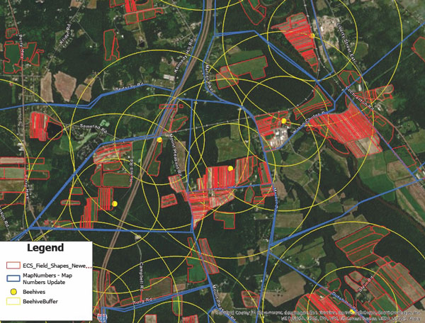
Ernst’s seed production relies on pollinators. Beehives are mapped and placed strategically across the fields to provide full coverage of seed crops. (Image courtesy of Ernst Seeds)
Every Monday and Wednesday, the team at Ernst Conservation Seeds gathers around maps to discuss which fields to harvest, which fields need treatments, and where to plant new crops.
On this 10,000-acre farm near the small town of Meadville, Pennsylvania, the company pioneered the propagation of 180 species of native wildflowers, grasses, and wetland plants to revive degraded land and provide wildlife habitat.
Now, the plants Ernst Seeds propagates are in high demand. Pollinator planting has become a trend worldwide, with the growing realization that flying bugs and birds are key to the survival of three-quarters of the world’s plants, including many we eat. Native plants are also being valued for nature-based solutions to protect soils from erosion and filter pollutants from stormwater.
Across its operation, Ernst Seeds embraces the science of agronomy and the use of geographic information system (GIS) technology to understand native plant species and grow them better, faster, and less expensively.
There’s a lot of experimentation that goes into growing native seeds and designing the right mix for each restoration project. “What we’re doing is going out and looking at existing plant communities to see what species grow together and how they’re doing it,” said Andy Ernst, vice president of Ernst Seeds. “Then there are lessons from our farming failures and successes. We make a lot of discoveries in our fields when we map yield data and the treatments we applied.”
Improving plant propagation
Typically, large farms focus on commodity crops like corn, soybeans, wheat, or cotton. At Ernst Seeds, the growing cycles of 180 species are tracked across 1,300 fields and 15 square miles.
“I realized a long time ago that with the complexity of our farm, we needed software to track it,” Ernst said. His early forays into traditional farm management software products were frustrating as most could not support so many crops. The software lacked the data management and analysis capabilities needed to discern best practices for seed crops no one else was growing.
Then in 2015, Ernst Seeds started using GIS. For operations, the ability to see fertilizer and spray assignments on smart maps helped the company identify places that required more or less treatment.
“There are a lot of accidental experiments when a row is skipped, there’s overlap, or a different chemistry is used,” Ernst said. “When we go out in the field, we can see areas that thrive and other areas that do poorly. With GIS, we can answer why.”
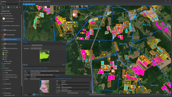
Katy Flaherty, an agronomy expert and the GIS manager at Ernst Seeds, developed a GIS-powered work order management system that guides each phase of production, from planting and fertilizing to applying pesticides and harvesting. The system uses a combination of ArcGIS Survey123, ArcGIS Field Maps, and ArcGIS Dashboards to record data and visualize trends. Flaherty also uses ArcGIS Pro to analyze data from the field, layering it with historical crop records and real-time soil and weather data to uncover correlations.
“When we plan our fields across four counties, there are significant differences in what crops do well from north to south,” Flaherty said. “It’s very spatial aware farming, and that knowledge transfers to recommendations for customers.”
In one instance, this detailed level of monitoring led to a decision to stop using a product that harmed some plants. In another case, improvements in propagation for a species proved so fruitful that smaller plots would meet the demand.
Smart maps guide the company’s planting locations, irrigation system maintenance, and harvesting schedule. Staff use smart maps to track plant maturity and time seed harvests. Unlike corn and soybeans, which can sit in fields for months, some native seeds have only three days of viable harvest. Knowing when and where to harvest is crucial. Ernst Seeds sells 70% of the seeds it harvests every year, putting the rest in the ground for the next crop cycle.
In ArcGIS Pro, administrators and agronomists view short-term plans and historical information. The map views allows them to analyze passes over fields, coverage of treatments, quantities of materials, water drainage, and other variables to inform treatment decisions. (Image courtesy of Ernst Seeds)
Filling gaps and expanding geographic reach
Calvin Ernst, Andy’s father, started the thriving conservation seeds business in 1964 with a Pennsylvania Department of Transportation contract to supply seeds to revegetate highway rights-of-way. Over the next 50 years, the company made wild seed collecting forays across the US to add plants to its offerings. As species count and seed supply grew, so did work with a broader list of customers, including state and federal agencies.
The company has developed seed mixes tailored to specific regions, such as Maryland, northern Virginia, and coastal North Carolina. These seeds are adapted to thrive in the local weather and soil. By choosing native seeds, restoration project managers ensure plants are well-suited to the ecosystem and more resilient to changing climate conditions.
“A simple philosophy is to avoid plants in your seed mixes that would be planted at the southern edge of their historical range,” Ernst said, speaking to the growing need for heat-adapted plants.
This commitment to innovation comes at a cost—it takes time to establish every new species. But insights from GIS can accelerate that timeline.
“It can take seven to 10 years to figure out how to grow something,” Ernst said. “If our observations cut that time down to five years, that’s a major win for us.”
Building native seeds capacity
One of the main challenges with native seed farming, according to Ernst agronomists, is the lack of knowledge of native seed production when compared to conventional row crops.
While the company has typically filled knowledge gaps itself, there have been times when an academic partnership has proved beneficial. For example, Ernst Seeds collaborated with researchers at the Center for Pollinator Research at Pennsylvania State University to identify the mix of flowering plants that could maximize pollinator food and breeding opportunities. The seed mixes developed through this partnership are now used across solar energy farms for revegetation.
The work on developing the right seed mix for solar farms made Ernst Seeds an ideal partner for the Virginia Solar Pollinator Program. Originally, Ernst Seeds was employed on the project by the Virginia Department of Conservation and Recreation to guide a mix of native seeds for Virginia, but that work expanded.
Ernst Seeds experts then worked alongside the Clifton Institute to gather seeds across Virginia, from the Coastal Plain to beyond the Blue Ridge Mountains. They recorded the location and conditions of their findings using a GIS-powered mobile app on their phones. This knowledge will help in planting along corridor projects, such as land beneath the electric transmission lines that will deliver energy from solar farms in rural areas to businesses and households in urban centers.
From its start with solar projects, the program evolved into the Virginia Native Seed Pilot Project to launch a native seed industry in Virginia. The program identifies local growers who can produce native seeds at a commercial scale and shows them how data from GIS helps guide best practices.
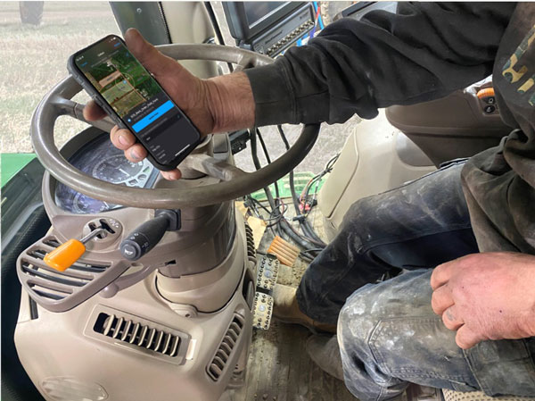
Tractor operators record their observations and have access to historical data as they work the fields. (Image courtesy of Ernst Seeds)
“Creating a GIS-centric culture at Ernst has changed how managers and operators work the fields,” Flaherty said. “We aren’t only looking at maps and numbers, we’re utilizing and making the data work for us every day.”
A data-driven approach to farming can be tough to instill in farmers working the same fields with the same approach for decades.
“Early on, we had pushback about the need to collect different information,” Ernst said. “Then in one meeting, we had a big lights-come-on moment when the answers we needed came from the data they’d been collecting. The guys were saying, ‘I know what we did there,’ but when we looked at the records their memory wasn’t as good as they thought it was.”
A roundup of recent products in the GNSS and inertial positioning industry from the March 2022 issue of GPS World magazine.
OEM
Correction Service
Achieves RTK-level accuracy
Photo: Hexagon
“RTK From the Sky” technology has been integrated into the core of the TerraStar-C PRO corrections service. As a result, TerraStar-C PRO provides centimeter-level accuracy, not just in open-sky environments but also across challenging conditions created by buildings and foliage. TerraStar-C PRO now converges in less than three minutes by utilizing quad-band receiver and antenna technology to leverage modernized BeiDou 3, GPS III and Galileo E6 signals. The resulting process generates state-of-the-art corrections for all GNSS frequencies. The service improvements are accessible through the 7.08.10 firmware release for users of OEM7700, OEM719 and OEM729 cards and their associated enclosures for land and air applications.
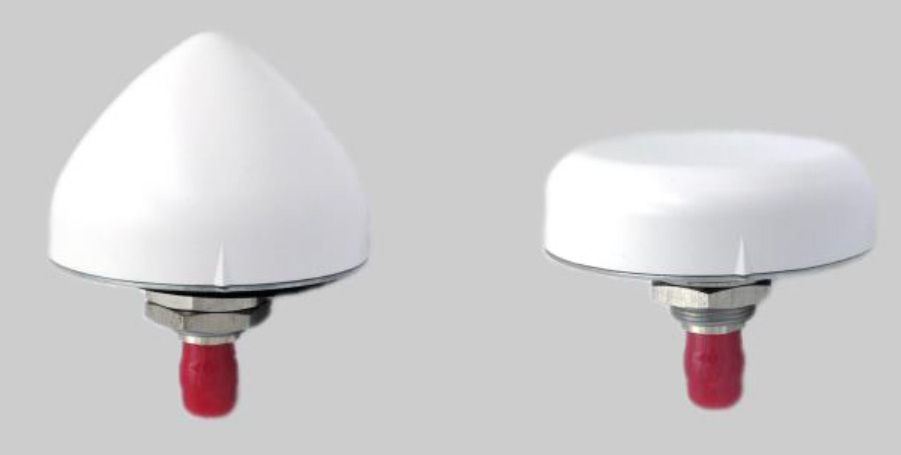
A north orientation mark is being added to the TW3000 family of Accutenna precision antennas and the TW5000 family of smart antennas. The new feature allows customers to align their antennas, standardize radiation patterns, and increase the synchronicity of their azimuth gain readings across multiple devices. The new north mark design has been thoroughly tested to ensure it conforms to or exceeds customer expectations and maintains each antenna’s stringent IP69K rating.
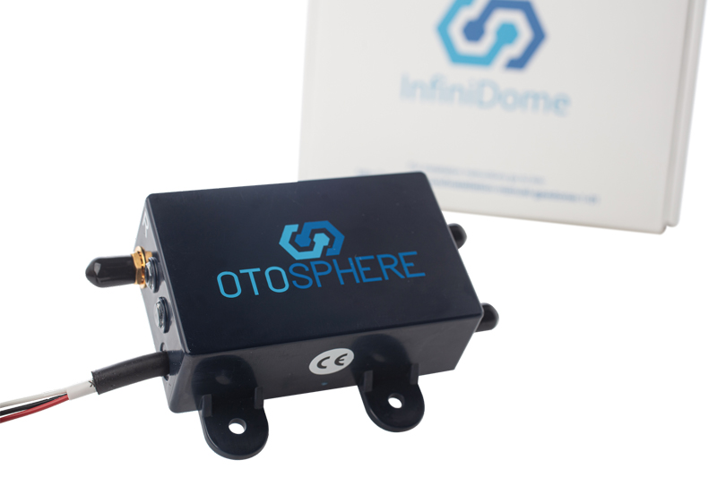
OtoSphere is a small, add-on module to the ViaLite GPS RF over fiber link and any GNSS-based system, providing GNSS protection against GPS jamming attacks, making any receiver more resilient. It ensures continuity of timing and navigation capability and enables normal operation during a jamming attack. According to ViaLite, no other solution that offers such protection is as small, light, affordable, or easy to install. The Otosphere protection module adds resilience to critical GPS timing services.Using OtoSphere, GPS receivers are up to 50 times more resilient to jamming attacks on positioning, navigation and timing (PNT) systems compared with having no protection. The GPS receiver can continue working normally throughout the attack. Timing-critical infrastructures in areas such as defense and cybersecurity can now be protected from these attacks. The Otosphere has a unique interference filtering algorithm that combines patterns from two external omnidirectional antennas that pinpoints the direction of the attack, then directs a null toward the unwanted signal to reject and reduce disruptions.
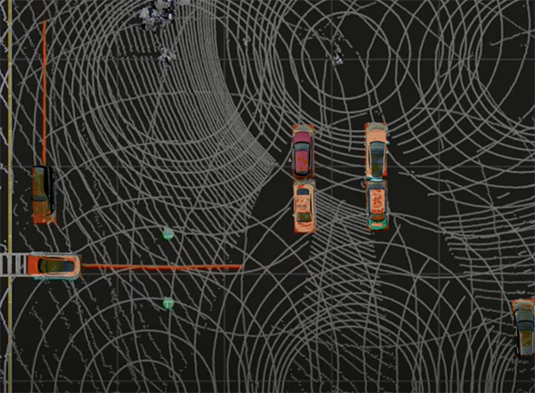
Infrastructure system for autonomous transportation
Photo: Seoul Robotics
The Level 5 Control Tower (LV5 CTRL TWR)) is a mesh network of sensors and computers on infrastructure that guides vehicles autonomously without requiring that sensors be placed on individual vehicles. The technology is automating last-mile fleet logistics at BMW’s manufacturing facility in Munich. The system has the potential to transform operations for a wide range of business applications, from vehicle distribution centers to car rental companies and trucking logistics.
Savvy Navvy provides essential marine information, allowing boaters to cross-check their traditional navigation plans. It integrates plotting charts, weather and tide data, marina details and passage planning into one app. The app reduces the risk of human error as well as the stress of voyage preparation. It is used by boaters in more than 100 countries around the world, with more than 43 million miles plotted. It works on phones or tablets using Android, IOS, PC or Mac.
The Pix4D viDoc RTK handheld rover attaches to iOS devices to bring RTK accuracy to terrestrial scanning on iPhones and iPads. When paired with the PIX4Dcatch mobile app, the viDoc rover can replace survey tools such as RTK GNSS rovers and terrestrial scanners, the company said. The two products create a workflow that turns iPhones or iPads into an accurate terrestrial scanning device, with centimeter-accurate RTK positioning from an existing NTRIP network. The tools can be used to 3D model small areas or structures.
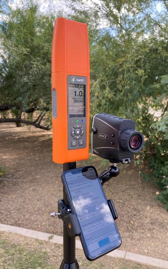
Bad Elf now provides an integrated laser-offset workflow for acquiring high-accuracy field data in GNSS-challenged environments using Esri ArcGIS Field Maps for Android, as well as iOS. The workflow integrates Bad Elf and Laser Tech (LTI) hardware in collaboration with ArcGIS technology from Esri. The Bad Elf Flex connects to any LTI TruPulse rangefinder over a wired or Bluetooth connection to deliver high-accuracy location data to Esri ArcGIS Field Maps. Mobile workers can efficiently complete position and height data collection in access-limited situations, saving time, money and effort.
A free global map created from processed satellite imagery is available. To create the world image, satellite imagery was processed to remove clouds and balance shades and tones, and then carefully stitched together to create a seamless map layer with beautiful colors. The input data is recent, from 2020 and 2021, and rendered as one tiled file with 13 zoom levels 0-13 for use in web applications. It is a viable, up-to-date alternative to Google maps for software developers, without privacy issues.
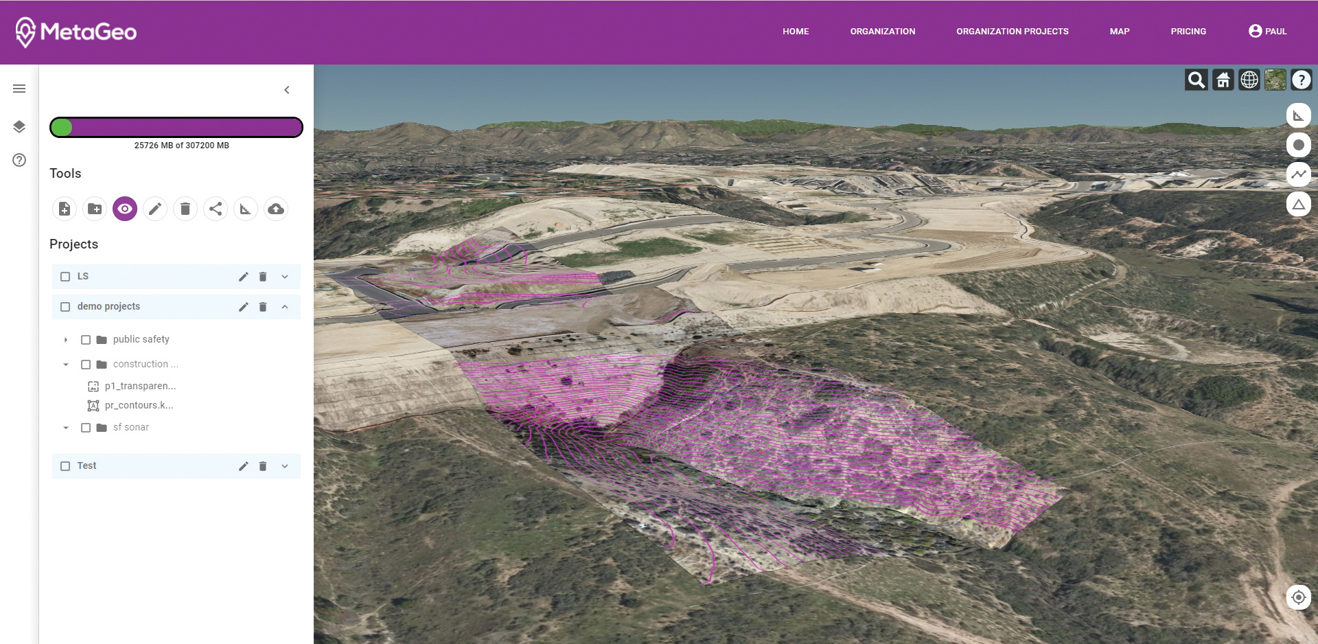
The MetaGeo geographic information system (GIS) platform enables organizations of all sizes to host, analyze, find and share 3D map datasets among any internet-capable devices. The platform processes location-based map or sensor data from the real world, combines it into a single 3D virtual environment, and streams it to any device or mapping platform. The affordable and easy-to-use platform can load data from multiple sources: satellites, drones, mobile devices, public and crowdsourced repositories, internet of things (IoT) sensor data, 3D models and topographic maps. The data is then processed by the MetaGeo platform into a 3D world and streamed to any internet-connected device, enabling live collaboration between the office and field via mobile or augmented reality device. A plug-in software development kit (SDK) allows for third-party tools to scale and fit user needs.
Trimble has launched the Trimble AP+ Land GNSS-inertial OEM platform for accurate and robust position and orientation for georeferencing sensors and positioning vehicles in land mobile-mapping applications. The platform enables users to accurately and efficiently track and monitor fleets and produce high-definition (HD) maps and 3D models. It can also serve as a reference solution for advanced driver-assistance systems (ADAS) testing, even in challenging GNSS environments. The comprehensive Trimble AP+ Land is small enough to integrate into compact mobile-mapping systems. It is compatible with virtually any type of mapping sensor, including single- or multi-lidar systems, video cameras, photogrammetric and panoramic cameras, and similar sensors.
Ronin 4D, a professional cinema camera from DJI, incorporates the full-frame Zenmuse X9 gimbal camera, active four-axis stabilization, lidar focusing, and wireless transmission. Firmware available at launch will allow the remote monitor to view and control the main monitor, interface with mirror control mode, and allow a clean video stream over HDMI and SDI ports on the Remote Monitor Expansion Plate with no overlaid information. It will also support automatic calibration for some third-party auto lenses to realize Lidar Focusing System functions.
Parallel Hybrid Electric Multirotor (PHEM) drone technology improves flight time with a heavy payload, yielding increased efficiency and eliminating the large battery used in other hybrids. It has the potential to extend a UAV’s flight time from 15 minutes to well over an hour and drastically increase range. In the search-and-rescue field, a heavy-lift drone can enhance first responder capabilities by allowing for substantially quicker response times to remote locations. Other applications include military platforms, fighting wildfires, and medical and logistics missions.
Bad Elf LLC now provides an integrated laser-offset workflow for acquiring high-accuracy field data in GNSS-challenged environments using Esri ArcGIS Field Maps for Android.
The workflow integrates Bad Elf and Laser Tech (LTI) hardware in collaboration with ArcGIS technology from Esri.
“Extending compatibility to the Android mobile operating systems further promotes our commitment to the bring-your-own-device (BYOD) professional,” said Larry Fox, vice president of marketing and business development at Bad Elf. “As a member of the Esri Partner Network, we are pleased to collaborate with Esri in offering this capability to our Android customers.”
The Bad Elf Flex connects to any LTI TruPulse rangefinder over a wired or Bluetooth connection to deliver high-accuracy location data to Esri ArcGIS Field Maps. Mobile workers can efficiently complete position and height data collection in access-limited situations, saving time, money and effort.
“With the inclusion of Android support, Bad Elf introduces a powerful and innovative solution for accurate location offset and height data capture that extends the capabilities of ArcGIS Field Maps across all supported platforms,” Esri Product Lead Jeff Shaner said.
Bad Elf’s app workflow focuses on enhancing productivity, reducing field collection difficulties, and mitigating quality issues. The Bad Elf app workflow runs on Android and iOS. Connection versatility minimizes operating system limitations and allows for app-based or standalone operation.
Bad Elf also provides free tools for Esri ArcGIS Desktop and ArcGIS Pro for configuring offset-enabled point-feature capture using the ArcGIS Field Maps on iOS and Android.
Bad Elf LLC and Laser Tech are providing an integrated laser offset workflow for acquiring high-accuracy field data in GNSS-challenged environments.
The new workflow integrates Bad Elf and LTI hardware in collaboration with ArcGIS technology from Esri.
The Bad Elf Flex GNSS receiver connects to any LTI TruPulse rangefinder over a wired or Bluetooth connection to deliver high-accuracy location data to Esri ArcGIS Field Maps. Field workers can now efficiently complete position and height data collection in access-limited situations, saving time, money and effort, the companies said.
“This collaborative integration effort empowers field data collectors to focus their time, energy, and budget on creating and maintaining their systems of record, instead of troubleshooting systems integration issues,” said Larry Fox, vice president of marketing and business development at Bad Elf. “As Esri Partners in the Esri Partner Network, we are pleased to collaborate with LTI in offering a straightforward workflow to our customers.”
“The ability to capture height measurements of an asset expands the data collection capabilities and ability to add more attribute data to the remote asset,” said Derrick Reish, senior product manager at Laser Tech.
Bad Elf’s app workflow focuses on enhancing productivity, reducing field collection difficulties, and mitigating quality issues. The Bad Elf app workflow runs on Android and iOS. Connection versatility minimizes operating system limitations and allows for app-based or standalone operation. Bad Elf also provides free Esri ArcGIS Desktop and ArcGIS Pro tools for offset-enabled point feature capture using the currently available ArcGIS Field Maps for iOS.
“The Bad Elf Flex, when paired with an LTI TruPulse rangefinder and ArcGIS Field Maps, delivers a powerful data collection solution,” said Esri Product Lead Jeff Shaner. “The innovative checklist-driven workflow delivers an intuitive, streamlined experience for advanced field workflows and the ability to provide a height calculation unlocks new opportunities for data capture.”
A roundup of recent products in the GNSS and inertial positioning industry from the August 2020 issue of GPS World magazine.
OEM
Photo: Xsens
RTK motion sensor
Provides Centimeter positioning
The MTi-680G is an integrated GNSS/inertial navigation system (INS) module that features an integrated real-time-kinematic (RTK) GNSS receiver, as well as providing synchronized 3D attitude and heading outputs. Its firmware accelerates the module’s internal signal processing compared to non-RTK modules. Synchronizing the global position coordinates with the module’s attitude, heading and velocity outputs, the MTi-680G can provide a comprehensive positioning and navigation output for any carrier device, including high-speed drones, at a maximum output data rate of 400 Hz. Other applications include precision agriculture, autonomous vehicles and coastal maritime equipment. Xsens provides out-of-the-box operation with MTi development kits.
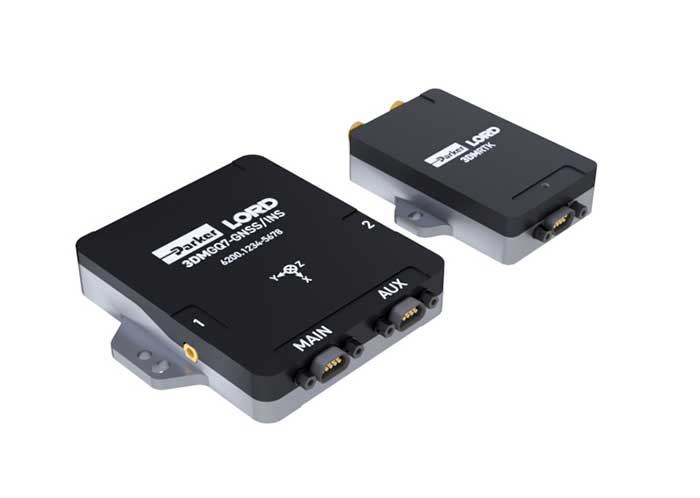
The 3DM-GQ7 is a dual-antenna real-time kinematic (RTK) inertial navigation system with multiple integrated aiding sensors and support for external aiding. It has two integrated RTK-capable multi-band multi-constellation GNSS receivers, integrated barometric pressure sensor, magnetometer, and hardware support for wheel odometry. It also has an application programming interface (API) for external sensor measurements. The 3DM-GQ7 provides seamless operation during temporary GNSS signal outages and online tracking of inertial measurement unit (IMU) error sources for superior dead reckoning. An optional network RTK receiver, the 3DM-RTK, allows users to communicate with the company’s SensorCloud RTK Connection network for an all-in-one solution.
Hexagon | NovAtel has released its first purpose-built driver, powered by Robot Operating System (ROS), to support its OEM7 family of GNSS receivers. The driver provides an optimized interface enabling users to accelerate autonomous development projects by quickly incorporating NovAtel OEM7 receivers into custom applications. The driver is available for immediate download through the new NovAtel GitHub repository or as a ROS Binary Package for direct installation.
The third-generation Ninja Precision Timing Module (PTM) — optimized for size, weight and power (SWaP) — can be easily integrated into 1U host systems or deployed as a cost-effective standalone time and frequency standard. The resilient GPS-synchronized Ninja is based on the core of EndRun’s Meridian II Precision TimeBase instrument, providing time accuracy of <10 nanoseconds RMS to UTC(USNO). Up to nine optional, user configurable, time and frequency outputs are available with accuracy, stability and ultra-low phase noise. Ninja’s network interface includes a robust Network Time Protocol (NTP) server as well as secure management.
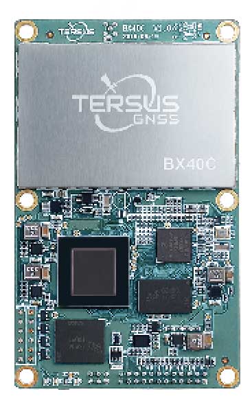
Powered by ExtremeRTK GNSS technology, the BX40C board can support multi-constellation and multi-frequency all-in-view satellite tracking to achieve centimeter-level positioning and improve the continuity and reliability of the RTK solution, even in harsh environments. Its enhanced positioning accuracy and constellation tracking can control deviation within 3 centimeters for surveying and mapping applications. It also is suitable for high-precision positioning. It can be integrated with autopilots and inertial navigation units. It offers 4 GB of built-in memory for data collection, and is compatible with other GNSS boards via flexible interfaces, smart hardware design and commonly used log/command formats.
The Spectratime mRO-50 is designed to meet the latest commercial, military and aerospace requirements where time stability and power consumption are critical. It provides a one-day holdover below 1 microsecond and a retrace below 1 x 10⁻¹⁰ in a form factor sized 50.8 x 50.8 x 19.5 millimeters. It takes up only 51 cc of volume and consumes only 0.45 W of power. The Spectratime mRO-50 provides accurate frequency and precise time synchronization to mobile applications, such as military radio-pack systems in GNSS-denied environments. It is also suitable for UAVs and underwater applications.
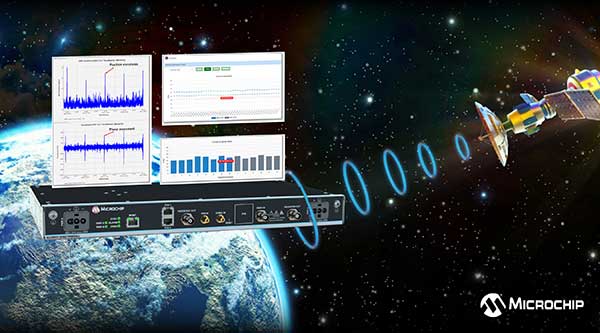
The BlueSky GNSS Firewall has received a major software update. The firewall provides a higher level of resiliency against GPS vulnerabilities for systems dependent on GPS signal reception. Microchip developed Release 2.0 to address operators’ evolving requirements after participating in GPS Testing for Critical Infrastructure events hosted by the Department of Homeland Security. It performs real-time analysis to detect jamming and spoofing for protecting reception of the GPS signal and hardening response and recovery to avoid signal disruption. Release 2.0 includes charting and advanced threshold settings of GNSS observables such as satellites-in-view, carrier-to-noise, position dispersion, phase time deviation and radio frequency power level to simplify system turn-up and deployment.
Particle’s Tracker SOM (system-on-module) provides a powerful GNSS receiver, microcontroller and advanced peripherals in a compact form factor. Tracker SOM can be tailored for organizations or serve as a fully certified foundation for OEMs developing commercial products. A high-gain GNSS antenna accurate to 1.8 meters is provided. The asset-tracking system is built on the Particle platform, spanning integrated internet-of-things (IoT) hardware, edge software, connectivity and cloud-based management software. It can track the real-time location of critical assets and capture additional intelligence such as temperature and acceleration as well as remotely control mobile equipment and vehicles.
The Geotab Public Works solution for North America helps state and municipal government agencies improve fleet operations and increase operational efficiencies. Fleet managers receive operational data on all government vehicle types on a single platform, with toolsets to remain compliant, reduce costs and maintain road safety. Vehicles tracked include salt spreaders, snowplows, street sweepers and waste-management vehicles. It supports material management, compliance, accountability and liability. Fleets can more accurately measure material usage, such as salt, and are better able to control costs and environmental impact. It is available as a configurable add-on for the MyGeotab platform, allowing municipalities of all sizes to customize their databases to help meet specific needs.
Scout provides the capability to securely obtain and broadcast a form of network remote ID. Because it is open source, both hardware and firmware can be enhanced and incorporated into a virtually limitless set of scenarios. Altitude Angel also has made available a surveillance API that allows integrators to both share and receive flight data from a variety of sensors and devices in near real time, providing a comprehensive real-time picture of the airspace. Scout offers two-way communication enabling the Altitude Angel UTM service to help the drone avoid collisions or restricted airspace. It will work in combination with a pre-flight (flight-plan sharing) service and is supported through integration with Altitude Angel’s Tactical Conflict Resolution Service. Scout will enable the drone to report its real-time location using GPS-type sensors and relay this data via a secure, encrypted mobile communications link to Altitude Angel.
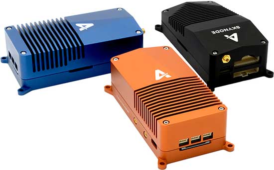
Unifies flight controller, mission computer and connectivity
Skynode unifies a flight controller, mission computer and wireless connectivity in a compact embedded design. It enables the complete Auterion software platform to accelerate the development of enterprise-ready products for drone manufacturers.Skynode can be integrated into any type of airframe: quads, multi-rotors, vertical-takeoff-and-landing (VTOL) and fixed-wing drones. Skynode enables the Auterion software platform with enterprise workflow integration, advanced autonomy features, mission planning, live video streams, operations dashboard, flight analytics and cloud-based predictive maintenance. Built on stable open-source software and industry standards, Auterion is highly interoperable with integrations from a host of partners in an open, future-proof ecosystem.
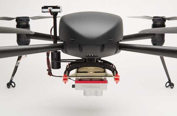
The Draganflyer Commander Ag-Pro Package includes everything needed to perform crop health assessment, irrigation monitoring and yield optimization. It combines the MicaSense RedEdge-MX multispectral sensor and the Draganflyer Commander UAV for projects requiring long flight times, a high level of data resolution and accuracy and data security. The Commander is an electric multirotor UAV built on Draganfly’s patented carbon fiber folding airframe. Its dual-battery system powers 35-minute flight times, and its automated flight planning tool allows users to quickly create coverage areas and flight plans. The RedEdge-MX features five narrowband imagers that capture high-quality images that can produce maps for a multitude of agricultural uses and has two calibration methods to produce accurate data that can be compared across time, allowing for temporal analysis throughout the season and from year to year.
Creates bare Earth models, cross sections, contours, volumetric analysis
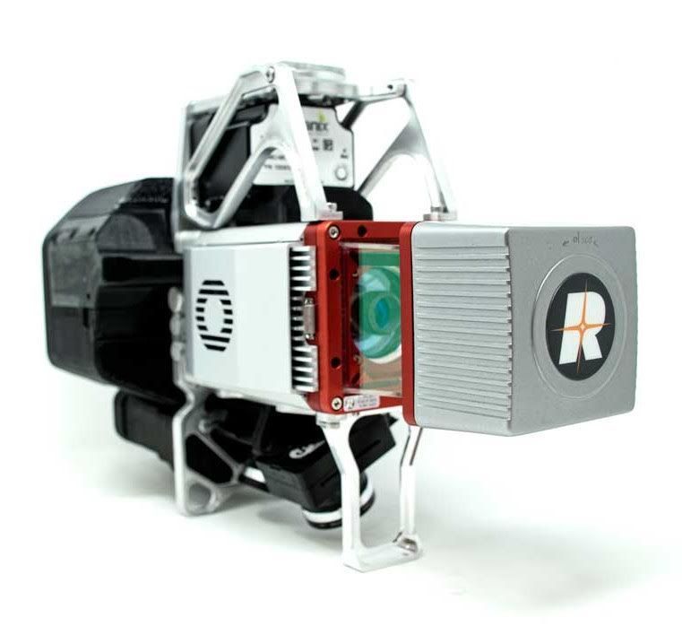
The True View 615 and 620 UAS lidar 3D imaging systems are compact, survey-grade sensors designed for small UAS. They are equipped with Riegl’s miniVUX-2UAV laser scanner integrated with dual photogrammetric cameras. Position and orientation is provided by an Applanix APX-15 (True View 615) or extreme accuracy APX-20 (True View 620). The systems are bundled with Applanix POSPac, True View EVO post-processing software and True View Reckon data-management solution. The system includes full post-processing software that generates a ray-traced 3D colorized point cloud and geocoded images.
Generates both survey-grade point clouds and high-resolution panoramas
The NavVis VLX wearable mapping system captures high-quality data in built environments such as construction sites, staircases and technical rooms. The compact, economical design enables high-quality data to be captured for architecture, engineering and construction (AEC) projects. Uses include conventional building documentation such as CAD drawings and BIM models, as well as web-based digital-twin solutions. NavVis VLX is equipped with two lidar sensors and captures survey-grade point clouds using the company’s SLAM technology, originally developed for the NavVis M6 indoor mobile mapping system. NavVis VLX also captures high-resolution panoramic images in a 360-degree field of view. The wearable device gives the operator more control over where the sensors are scanning. A built-in screen provides live feedback of what has been scanned and the quality of the data being captured.
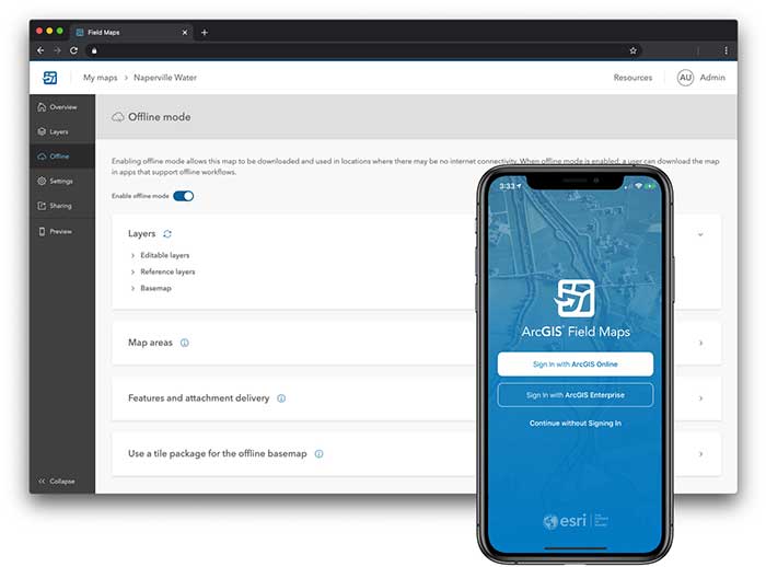
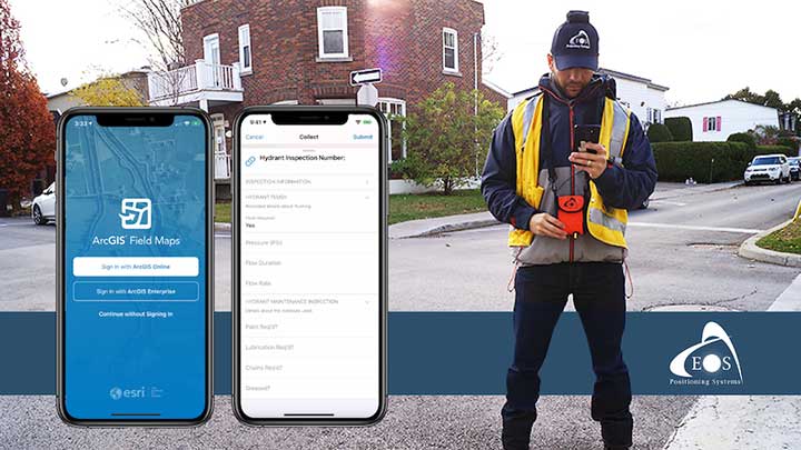
ArcGIS Field Maps, coming in September, will combine the following capabilities into a single app: map viewing and markup, high-accuracy field data collection and inspection, battery-optimized location tracking, work planning and task management and turn-by-turn navigation. Field Maps also will include a new web app, integrated with ArcGIS, that can be used to configure and deploy maps optimized for your mobile workforce needs, create and assign tasks to mobile workers, and create and share views of worker locations. ArcGIS Field Maps combines the functionality of five Esri ArcGIS mobile apps: Collector, Explorer, Tracker, Workforce and Navigator. Field Maps will also support the two formerly Collector-exclusive Eos solutions: Eos Locate and Eos Laser Mapping.
Eos will announce compatibility of its Arrow GNSS receivers with the inaugural ArcGIS Field Maps beta release, the expansion of Eos Locate underground mapping locator-device compatibility, as well more exciting updates for users of high-accuracy GPS with ArcGIS apps.
Eos Positioning Systems, manufacturer of the high-accuracy Arrow Series GNSS receivers for the GIS market, has announced several new releases ahead of the 2020 virtual Esri User Conference.
The announcements include the expansion of the availability of the Eos Locate
underground mapping solution, compatibility with the new ArcGIS Field Maps, the inaugural release of Eos Tools Pro for Windows, and a “special surprise” for virtual attendees of the 2020 Esri UC.
Image: Eos Positioning
Expansion of Eos Locate
Eos Locate is a high-accuracy, real-time underground mapping solution for Esri
ArcGIS apps users. It allows organizations to accurately map already-buried assets straight to ArcGIS Online via either ArcGIS Collector or ArcGIS Field Maps.
Eos has expanded Eos Locate compatibility with additional models from Vivax-Metrotech, Subsite and Radiodetection.
Compatibility with ArcGIS Field Maps beta
ArcGIS Field Maps is the newest Esri mobile application, which combines the functionality of several existing Esri mobile applications, such as ArcGIS Collector, ArcGIS Explorer, and ArcGIS Tracker.
The ArcGIS Field Maps beta release this month is already fully compatible with Arrow GNSS receivers (all models). This means organizations with Arrow GNSS receivers can immediately start taking advantage of survey-grade Arrow GNSS locations and metadata within ArcGIS Field Maps for data collection, markups, read-only routine field work (e.g., utility locates), GPS tracking, and more.
In addition, two Eos solutions previously exclusive only to Collector also already work with ArcGIS Field Maps. These include:
Eos Tools Pro is a free GNSS monitoring application for Arrow GNSS receivers. For the first time, this app is now available for Windows 10 users.
Eos Tools Pro allows fieldworkers to:
Connect to an RTK network or base station via NTRIP
Get elevations in orthometric heights via geoid model conversions in real time, in the field (directly into an Esri app)
Apply a simple X, Y, Z datum shift to the current location to match any local datum
Set a vast number of audible alarms
In addition, developers using Windows 10 will now be able to access the wide array of Arrow GNSS metadata while eliminating the task of parsing NMEA data.
Finally, Eos Tools Pro features a built-in duo of virtual Com Port and TCP/IP server to output streams of standard NMEA sentences. This enables multiple apps to have simultaneous access to the Arrow GNSS location and metadata.
Special surprise for eligible 2020 Esri UC attendees
In support of the inaugural virtual Esri UC, Eos is offering a one-time-only chance to win an Arrow 100 submeter GNSS receiver. To enter to win, eligible attendees must both
Complete a meeting with an authorized Eos representative during the 2020 Esri UC (July 13-16), which can be achieved by visiting the Eos virtual booth (V103), and
Fill out a special contest contact form made available by that representative.
Both the meeting and special contest contact form submission must be completed no later than July 16.
The following people are not eligible to win: Employees of Eos and Eos distributors, employees of Esri and Esri distributors, employees of other exhibiting/sponsoring companies, employees of other GPS manufacturers or vendors, registered media, and others whom we deem to have a similar affiliation.
Visit the Eos virtual booth (V103) to talk with sales, marketing, and technical support staff during the event expo hours.
A new Esri mobile app, ArcGIS Field Maps, will be released in its first beta in July, with the final version expected to be released in September.
According to Esri, Field Maps will combine the following capabilities into a single app:
Simple map viewing and markup
High-accuracy field data collection and inspection
Battery-optimized location tracking
Work planning and task management
Turn-by-turn navigation
Field Maps also will include a new web app, integrated with ArcGIS, that can be used to configure and deploy maps optimized for your mobile workforce needs, create and assign tasks to mobile workers, and create and share views of worker locations.
Arrow support included
The inaugural beta includes support for Arrow GNSS receivers’ high-accuracy locations, elevations and metadata, according to Eos Positioning.
ArcGIS Field Maps will provide the combined functionality of five Esri mobile apps: ArcGIS Collector, ArcGIS Explorer, ArcGIS Tracker, ArcGIS Workforce and ArcGIS Navigator.
In the first beta version, users will be able to perform markups, work with read-only maps, and work with MMPKs, including high-accuracy GPS locations and metadata from Arrow GNSS receivers.
Photo: Eos Positioning
Customers who have been wanting to take advantage of high-accuracy GNSS data in apps such as Explorer and Tracker will now be able to with the beta release. Customers who would like to have field crews able to access read-only maps with high-accuracy, for instance (such as during utility locates), this is now a possibility. In addition, crews can take advantage of high-accuracy GPS tracks while tracking.
ArcGIS Field Maps will also support the two formerly Collector-exclusive Eos solutions Eos Locate and Eos Laser Mapping.
Eos Locate. This high-accuracy underground mapping solution will be available in ArcGIS Field Maps right away in the first beta release. A single fieldworker will be able to perform real-time, high-accuracy mapping of underground assets using the same workflow he or she had previously used with Collector and Arrow GNSS.
Eos Laser Mapping. Similarly, laser offsets with Arrow GNSS receivers and LTI laser rangefinders will be available in the first beta of ArcGIS Field Maps. Learn more about laser offsets, including the three workflows for using them, here:
“We are incredibly excited for the new opportunities ArcGIS Field Maps brings to expand our partnership with Esri,” Eos CTO Jean-Yves Lauture said. “Now our joint customers will be able to use the Arrow GNSS receivers with Field Maps to access high-accuracy location when simply viewing and marking up maps and when logging location tracks.”
Eos Positioning told its customers, “We encourage all Eos customers currently using Collector, Tracker and/or Explorer to join the beta. Meanwhile, Collector, Tracker and Explorer are planned to continue working as usual, according to the roadmap Esri has outlined.”