Tag: Arizona

  • Cohda Wireless to support landmark V2X deployment in Arizona

    Cohda Wireless to support landmark V2X deployment in Arizona

    The Maricopa County (Arizona) Department of Transportation (MCDOT) has selected connected-vehicle technology specialist Cohda Wireless to support delivery of its Connected Vehicle
    Acceleration Zone (CVAZ).

    The CVAZ is a USDOT-backed deployment designed to accelerate interoperable vehicle-to-everything (V2X) technology across key corridors in the county. CVAZ forms part of the Federal Highway Administration’s “Saving Lives with Connectivity: Accelerating V2X Deployment” program, which is supporting national models for connected vehicle deployment in Arizona, Texas and Utah.

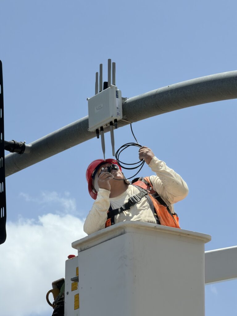
    The Maricopa County project will rely primarily on 5.9 GHz
    communications and is expected to connect up to 750 physical and virtual roadside units with 400 onboard units across transit, emergency response and freight fleets.

    The deployment will support emergency vehicle pre-emption, vulnerable road user alerts, transit signal priority and freight signal priority in Phoenix, Tolleson, Avondale and unincorporated Maricopa County, as well as along ADOT’s US 60 highway.

    Together, these applications are intended to help emergency vehicles move more efficiently through intersections, improve transit reliability, reduce freight delays and provide earlier warnings around pedestrians and cyclists.

    Following its selection as a vendor, Cohda is contributing technical expertise in testing and deployment planning to support delivery of the CVAZ application zones. Under the project, Cohda will supply MK6 Road-Side Unit (RSU) kits and MK6 On-Board Unit (OBU) kits across the CVAZ application zones.

    The program is designed as a multi-vendor deployment. Cohda’s RSU and OBU platforms are positioned to integrate with the county’s selected roadside processing environment, helping reduce integration risk and support faster deployment.

  • BAE Systems laser-guidance kits tested by US counter-UAS office

    BAE Systems laser-guidance kits tested by US counter-UAS office

    Image: BAE Systems
    Image: BAE Systems

    The Joint Counter-Small Unmanned Aircraft Systems office successfully tested BAE Systems’ APKWS laser-guidance kits in a counter-unmanned aircraft systems (C-UAS) mission.

    During the Department of Defense-led exercise at Yuma Proving Ground, Arizona, the 70 mm APKWS-guided rockets demonstrated 100% effectiveness when fired against 25-to-50-pound UAVs traveling at more than 100 miles an hour. The APKWS C-UAS solution is platform agnostic, permitting multiple options to accelerate fielding.

    APKWS transforms unguided rockets into smart munitions for precision strikes on soft and lightly armored targets. An updated proximity fuse for the standard M151 warhead enables laser-guidance kits to target Class-2 and Class-3 UAVs, which typically weigh less than 55 lbs. The fuse retains the legacy point denotation capability for flexibility of the weapon in the field.

    APKWS now enables rockets to engage and destroy UAVs at a fraction of the cost of existing C-UAS systems with unprecedented precision.

    The kits are available to all U.S. armed forces, as well as allies via foreign military sales.

  • Walmart launches UAV for deliveries in Utah

    Walmart launches UAV for deliveries in Utah

    Image: Walmart
    Image: Walmart

    Two Walmart locations in Utah, one in Lindon and one in Herriman, are now providing UAV delivery for customers nearby. Walmart has UAV deliveries operated by DroneUp, Flytrex and Zipline at 36 stores in the United States.   

    For a $3.99 fee, customers within a mile of the stores can receive their groceries via UAVs. The two Walmart locations in Utah can deliver more than 120 times per day and each UAV can carry up to 10 pounds. The hubs for deliveries are in the parking lots of each Walmart location and are operated by Federal Aviation Administration-certified pilots. 

    Walmart is using UAV delivery in seven states, including Florida, Arizona, Texas, Utah, Virginia, North Carolina and Arkansas. The most common products delivered include ice cream, lemons, rotisserie chicken, Red Bull and paper towels, according to Walmart.   

    Walmart drone deliveries launched in October 2019 in Arkansas. In 2022, Walmart completed more than 6,000 deliveries across all 36 participating locations. 

  • UAVs help solve challenges at an Arizona open-pit mine

    UAVs help solve challenges at an Arizona open-pit mine

    Photo: Synergy Geomatics
    Photo: Synergy Geomatics

    UAVs provided Synergy Geomatics with the safest and most effective way to survey and map a 2,400-acre open-pit mine, and collect about a gallon of water from the bottom of the pit.

    The Phoenix, Arizona-based survey, mapping and inspection company took on these two tasks at the Sacaton Mine in Casa Grande, Arizona, which shut down in 1984.

    With an old mine of that size, the topographic survey was a large undertaking that lasted several days, said Synergy Geomatics CEO Doug Andriuk. A JAVAD-1M receiver and Triumph-LS real-time kinematic land survey machine were used to set and collect about 80 ground control points.

    “This is outstanding survey gear for a large project like this,” he said. “The batteries last 24 hours, the setup takes a couple of minutes, and the multitude of radio options keep us connected all over the project. The dataset was comprised of more than 6,000 images and took several days to process.”

    One day of field work followed by 1.5 hours of image capture using a Cessna 172 equipped with the Syn-Cam was required to map the mine.

    The company used a proprietary method to collect high aspect imagery of the mine pit, because it allowed for a greater level of accuracy on steep surfaces. Manual and algorithmic filtering removed all the vegetation and structures on the site, and then generated 1- and 5-feet contours.

    Collecting water from the bottom of the mine pit presented Synergy Geomatics with several challenges. It had been 30 years since anyone had been to the bottom of the pit, and the roads that led there had washed away long ago.

    The use of a manned helicopter was briefly considered, but was not going to work in the tight, 1,500-foot-deep pit.

    “We had a better, safer and less expensive solution,” Andriuk said. “We proposed the use of a drone carrying a water-sampling bailer, which is a poly tube with only a one-way check valve on the end. You can dip it in the water, and it will just keep filling up.”

    Not only did the drone have to descend 1,500 feet, it had to collect water, too. Testing the drone’s capabilities to collect and carry nearly a gallon of water helped ensure the company would complete the task successfully with a few modifications.

    “Multicopters don’t like to descend straight down, as they hit their own propwash, so a spiraling descent has to be made without hitting the walls of the pit,” he explained. “Then the drone must dip the bailer and ensure that it collects the right amount of water.”

    Holes were drilled into the bailer to limit the amount of water collected. That way, the drone was not overloaded and could travel safely back to its landing zone with the additional weight.

    Determining how high the drone needed to be above the water surface also posed a challenge.
    “We opted to use two drones, a large one for the water sample and a smaller drone with a high-definition camera to give the pilot of the first drone clear visibility of the bailer over the water,” he said. “It took four trips, each lasting about 10 minutes, to collect a full gallon of bright green highly alkaline mine pit water.”

    Image: Synergy Geomatics
    Image: Synergy Geomatics

  • CHC Navigation opens NA headquarters in Arizona

    CHC Navigation opens NA headquarters in Arizona

    Photo: CHC Navigation
    Photo: CHC Navigation

    Shanghai-based GNSS technology and solutions company Shanghai Huace Navigation Technology Ltd. — known as CHC Navigation — has opened a North American subsidiary, CHC Navigation USA Corporation, in Scottsdale, Arizona.

    CHC Navigation was established in 2003 and was ranked as one of China’s top GNSS and RTK technology and solutions companies in 2017. It has customers in more than 100 countries worldwide and has been providing GNSS and RTK products and solutions to the US marketplace since 2009.

    The establishment of a North American head office in Scottsdale illustrates CHC Navigation’s ongoing commitment to expanding its products, services and customer support in the U.S. and North American marketplaces.

    CHC USA will warehouse, sell and service from Scottsdale all of its products to its dealer and OEM network of customers across North America. With the new U.S. presence, CHC USA will be able to respond more quickly to its dealer and customer order requests and service requirements.

    CHC USA specializes in CORS GNSS base-station infrastructure, deformation monitoring, surveying and mapping. With new 3D lidar scanning and hydrographic unmanned survey vessels launching later this year, CHC USA’s North American office and team members will continue to focus on ensuring a great customer experience.

    “On the heels of strong CHC Navigation growth in the US in 2018, the time was right to establish a domestic US sales and service office and warehouse with a local team of positioning industry professionals,” said George Zhao, CEO of CHC Navigation. “Our U.S. and Canadian customers have been very supportive of CHC Navigation over the years and our focus will continue to be on providing industry leading products and services to our valued North American dealers and customers,” added Phil Gabriel, President of CHC Navigation USA.

  • For those who served: GNSS helps expand Arizona national cemetery

    For those who served: GNSS helps expand Arizona national cemetery

    The base of the channel was just wide enough (12 feet) to fit the John Deere machine for grading the 2:1 slope. With GNSS, the operator did not have to reference grade stakes or stop for grade checks. (Photo: Topcon)
    The base of the channel was just wide enough (12 feet) to fit the John Deere machine for grading the 2:1 slope. With GNSS, the operator did not have to reference grade stakes or stop for grade checks. (Photo: Topcon)

    Noel Guevara, president and owner of JAG Construction, considers it an honor to have been involved in a project to expand the National Memorial Cemetery of Arizona.

    To get the job done as quickly and efficiently as possible, the fledgling company drew upon GNSS technology for the bulk of its grading and specialized excavation needs.

    Doing so, it was able to wrap up the major expansion on time, with as little disruption as possible.

    Additional Space Needed. The cemetery expansion will help alleviate a shortage of burial space brought about by the passing of veterans of World War II, the Korean Conflict and the Vietnam War.

    The project involves development of 22 acres adjacent to the existing cemetery including construction of two columbarium courts to house 4,688 niches for cremains; 2,180 pre-placed crypts; grading for 1,900 in-ground cremains; 650 linear feet of roadway; two retention ponds; and 1,350 feet of shotcrete drainage channel.

    A look around the expansion site — previously scrub land — revealed few grade stakes, a sign that GNSS technology was at work. “I first used GPS when I was with a company back in 2000,” Guevara said. “So I know the tremendous boost in productivity it can give, and felt that I had to have it on this project.”

    Critical Support. While Guevara may have felt at home with machine control, some of his team needed a crash course in working within a GNSS environment. RDO Integrated Controls outfitted JAG’s two motor graders with Topcon 3D-MC2 machine control in a twin-antenna, single-mast configuration.

    Guevara’s decision to place his faith in the GNSS solution put his company at what Topcon calls the “intersection of infrastructure and technology,” a conceptual crossroads where Topcon helps industry professionals best meet growing infrastructure demands through technological innovation — increasing both productivity and profitability.

    A Channel Runs Through It. Though the majority of the cemetery expansion site is relatively flat, the retention ponds and drainage channel could have proven problematic, had they been done using traditional survey methods.

    Guevara said being able to do the detail work with the Topcon system dramatically ramped up production.

    “This is easily 70% faster than doing things old-school,” he said. “Having the blades equipped with GPS gave us the confidence to walk away each day knowing that the numbers were there.”

    JAG was also contracted to excavate foundations for a pair of columbarium courts. Guevara once again turned to GNSS to streamline that effort, specifically a dual-antenna Topcon MC-i3 system with a GX-55 control box.

    “Because of the GPS system on that machine, the operator knew exactly how far down he had to go; there was no questioning or verifying depths — that was a nice solution for us.”

    In 2017, JAG invested in six GNSS-based machine control systems. This year they are looking at additional machine purchases to meet what is forecast to be more than double 2017’s numbers.

  • HxGN SmartNet, AZGPS to expand GNSS correction services in US

    HxGN SmartNet has partnered with AZGPS LLC to expand access to quality network correction services for GNSS users in the southwestern United States.

    HxGN SmartNet, a high-precision, high-availability GNSS network correction service, is provided by Hexagon’s Geosystems division. AZGPS, based in Florence, Arizona, serves professionals across Southern California and Arizona who rely on high-precision GNSS with network correction services, professional support and training.

    The company will remain the local point of contact in the region and now has access to the infrastructure and resources of HxGN SmartNet, including HxGN SmartNet stations and a wide array of Hexagon services.

    “Our number-one goal is to help our customers succeed,” said Travis Thompson, AZGPS. “The ability to leverage the resources of HxGN SmartNet will enable AZGPS to provide even more benefits to GNSS users. We look forward to continuing the superior service our customers have come to rely on for more than 13 years while staying on the leading edge of technology.”

    HxGN SmartNet is fully open to all makes and models of GNSS equipment and is designed to provide the highest reliability and accuracy 24/7. Launched in 2010, HxGN SmartNet is a commercial GNSS network that offers a single connection point for coverage across North America.

    Built on the most advanced GNSS reference station software platform in the world, Leica Geosystems GNSS Spider, HxGN SmartNet provides high-precision, high availability network real-time kinematic (RTK) corrections for any application, the company said.

    A variety of different subscription plans are available at the state, regional and national level for any application requiring precision GNSS corrections. With more than 1,300 stations in 45 states and eight provinces, HxGN SmartNet North America offers extensive network coverage.

    “GNSS users across all applications know they can rely on HxGN SmartNet to make the investments and partnerships needed to provide the easiest, fastest and most precise positions in the industry,” said Wendy Watson, director of operations for HxGN SmartNet North America. “AZGPS has a long track record of providing excellent service to GNSS users in the Southwest through the AZGPS and CALVRS networks. This cooperation between two familiar names in the positioning services industry underscores HxGN SmartNet’s commitment to ‘any constellation, any application and open to all.’”