Tag: ArkEdge Space

  • ArkEdge Space study examines system for non-GNSS LEO PNT

    ArkEdge Space study examines system for non-GNSS LEO PNT

    ArkEdge Space Inc. has completed a study commissioned by the Japan Aerospace Exploration Agency (JAXA) on “Elemental Technologies and Systems for a Dedicated, GNSS-Independent LEO-PNT Satellite System.”

    Positioning, navigation and timing derived from GNSS is increasingly subject to interruption and interference, both through environmental and security challenges. Finding methods to protect PNT information against such interference is of paramount importance for governments and commercial actors alike.

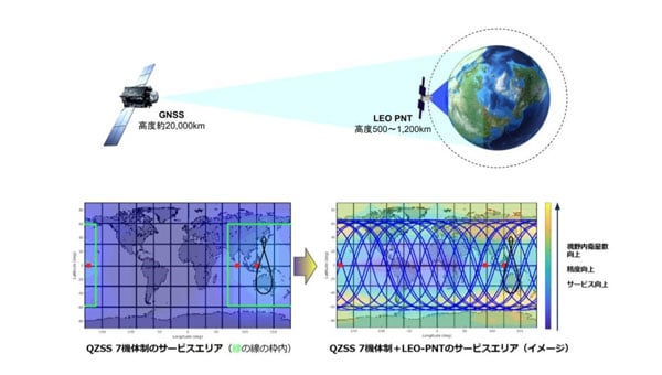
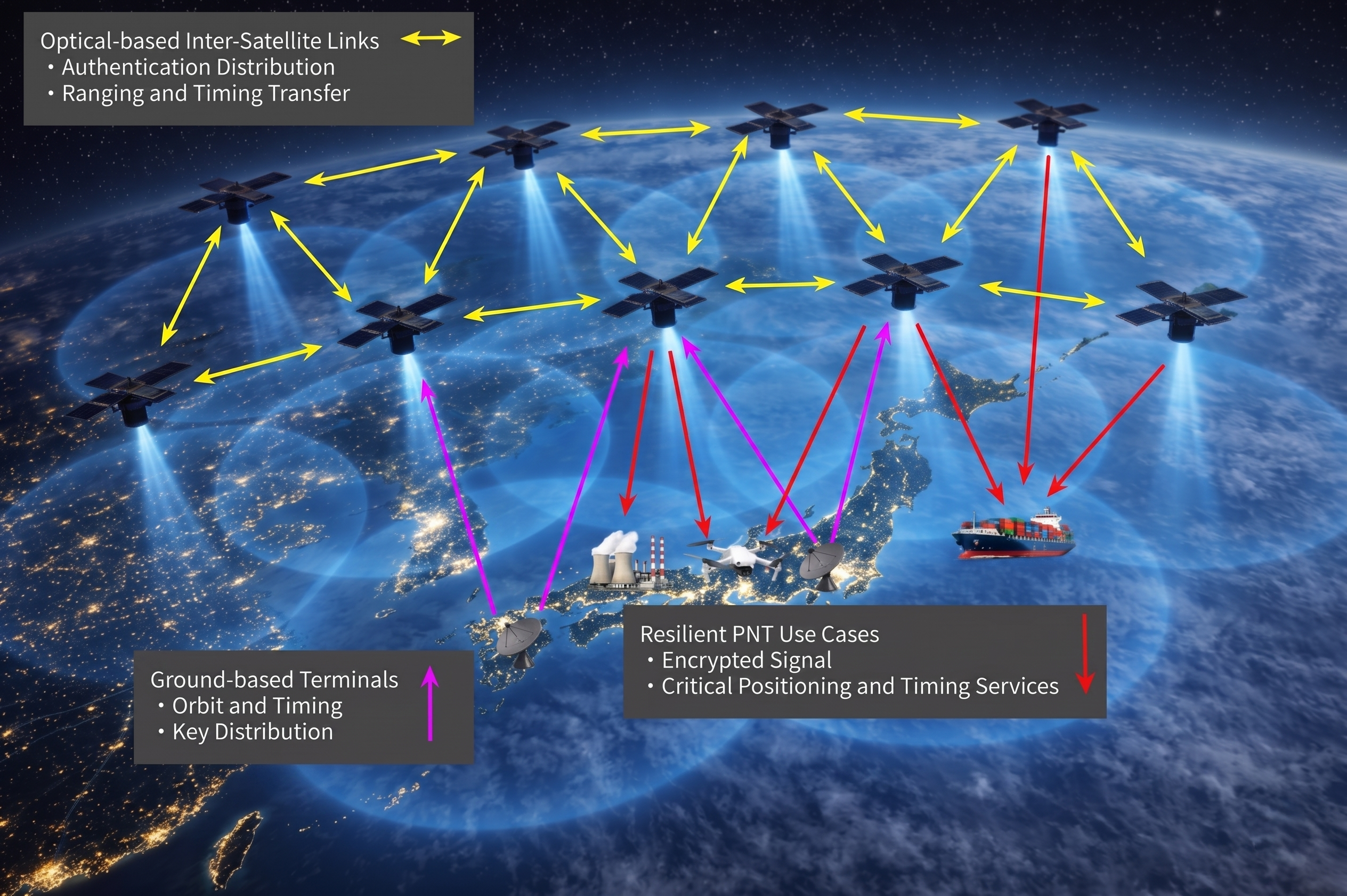
    The ArkEdge/JAXA project addressed such challenges by examining and categorizing the necessary elemental technologies — signal design, receiver technology, ground infrastructure, satellite sensors, and the overall system architecture — required to realize a LEO-PNT system capable of providing PNT without reliance on traditional GNSS.

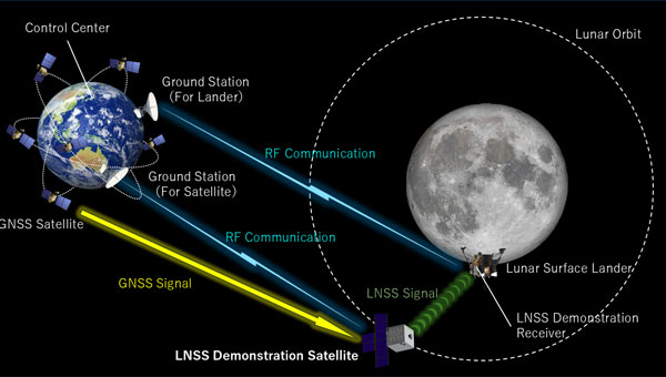
    The study’s focus included achieving satellite orbit determination and time synchronization without GNSS, one of the key challenges facing alternative PNT providers. It explored a new architecture for onboard time determination that avoids the need for large atomic clocks. Instead of onboard clocks, the system transmits precise timing information from combinations of ground-based reference clocks, pseudolites and inter-satellite optical links to disseminate information and enable on-orbit ODTS.

    Concept art of the LEO-PNT satellite constellation. (Credit: ArkEdge Space)
    Concept art of the LEO-PNT satellite constellation. (Credit: ArkEdge Space)

    The study considered diverse frequencies to strengthen anti-jamming measures. It also looked at novel signal design, receivers, encryption and signal authentication methods, and their suitability for LEO-PNT satellites. Results of the study will contribute to the next stage of development for a GNSS-independent LEO-PNT concept.

    “This study is critical to advancing our understanding of Japan’s future relationship with PNT,” said ArkEdge Space Chief Strategy Officer Tomoaki Yasuda. “Across the world, users are facing denial of GNSS services, and that can have critical consequences for sectors including the economy, transport and emergency services, among others. We look forward to progressing the GNSS-independent LEO-PNT concept with the support of our partners.”

    “Due to the prevalence of GNSS interference, alternative PNT systems are becoming increasingly important to protect users and assets such as critical national infrastructure,” said Masaya Murata, JAXA. “Following the successful conclusion of this GNSS-independent LEO-PNT study with ArkEdge Space, our investigation into a robust and resilient LEO-PNT system continues. We are also emphasizing international cooperation with other LEO-PNT providers to maximize users’ PNT experience and continue to engage in collaborative discussions.”

  • ArkEdge builds micro-satellite constellation for maritime real-time tracking

    ArkEdge builds micro-satellite constellation for maritime real-time tracking

    ArkEdge Space successfully launched its micro-satellite AE1a on March 30, and has begun initial checkout following the establishment of communications through test radio signals.

    AE1a is a technology demonstration satellite developed to advance maritime digitalization by enabling wide-area, real-time vessel tracking and communications. The satellite adopts ArkEdge Space’s standardized 6U satellite bus in its large-antenna configuration. In addition to demonstrating a deployable antenna for VDES (VHF Data Exchange System) applications, AE1a will improve and validate core technologies for a VDES receiver.

    AE1a will operate in coordination with AE1d, which began operations in January 2025, and AE3Va, which began operations in June 2025, forming a three-satellite constellation for demonstration across wide-area maritime areas.

    AE3Va continues to acquire AIS signals across multiple sea areas, including waters around Japan and vessel-congested areas along critical shipping lanes. Accumulated reception data is being systematically verified and analyzed.

    Going forward, the program will advance from reception-focused demonstration to two-way communications, including transmission from orbit. This will enable satellites to deliver operational information directly to vessels, expanding the scope of VDES demonstration and advancing progress toward concrete use-case validation across the maritime sector.

  • ArkEdge Space with consortium to accelerate space business co-creation in Africa

    ArkEdge Space with consortium to accelerate space business co-creation in Africa

    ArkEdge Space Inc. has formed a consortium with General Incorporated Association Cross U, Axelspace Corporation, and Double Feather Partners to promote co-creation in the African space market. The four organizations entered into a memorandum of understanding (MoU) on Feb. 18 to establish a framework for collaboration.

    ArkEdge Space is a Tokyo-based space start-up delivering micro-satellite constellations from design to operations.

    The consortium seeks to move beyond conventional official development assistance frameworks by directly connecting Japan’s advanced space technologies with the private-sector dynamism of African nations. It will embed Japanese digital infrastructure, including satellite systems, data platforms, and space-enabled services, into Africa’s social and economic foundations.

    Through this approach, the initiative aims to operationalize within the space domain the principles of Japan’s “Free and Open Indo-Pacific” vision, originally advocated by the Japanese government in 2016 under then-Prime Minister Shinzo Abe.

    Sustainable co-creation model
    Across Africa, countries face urgent challenges, including climate change-driven droughts and floods, food security risks, and growing infrastructure demands from rapid urbanization. Satellite data and space-based technologies offer concrete tools to address these issues; however, limited local infrastructure, institutional readiness, and operational know-how continue to constrain practical implementation.

    Through the Cross U Africa Initiative Working Group established in November 2025, the four organizations collaborated with more than 20 Japanese partners across industry, academia and government to explore concrete models for co-creation with African nations.

    In January, the parties established the consortium to move beyond the cooperation phase and enter an implementation phase, driving concrete, private-sector-led business across the continent, following participation in the Ministry of Foreign Affairs of Japan’s Public and Private Joint Mission for Promoting Trade and Investment in Africa.

    The consortium seeks to bring to life, within the space industry, the principle of “co-creation of innovative solutions” set forth in the Yokohama Declaration adopted at TICAD 9. Rather than simply transferring technology, it aims to build genuine partnerships with African business counterparts and cultivate a space industry ecosystem that drives economic growth for both Japan and African nations.

    Co-creation in Ethiopia using satellite data
    A pilot project was launched in Ethiopia in Ethiopia in January when Axelspace and Ethiopian technology company Jethi Software Development PLC signed a MoU to collaborate on the use of satellite data to address pressing social challenges. Ethiopia will serve as a reference model for future expansion across the continent.

    By integrating Axelspace’s expertise in high-frequency satellite data analytics with Jethi’s local network and software development capabilities, the partners will develop solutions targeting Ethiopia’s most pressing priorities, including agricultural productivity, forest conservation, and urban planning optimization.

    The project aims to establish a sustainable business model in which local enterprises independently operate and monetize satellite-enabled services. Through this model, Japanese space technologies can be embedded into Ethiopia’s social and economic infrastructure, enabling both sustained business growth and measurable social impact.

    Outlook
    In April, consortium members will return to Africa to engage in discussions with local public institutions aimed at forming additional implementable projects and advancing new co-creation models.

    As a key year for translating TICAD 9 commitments into tangible action, the consortium will present progress updates at Nihobashi Space Week 2026 in November, one of Asia’s largest space business events.

    The consortium will continue expanding partnerships across African nations, with the goal of embedding space-based technologies into local economies and fostering industries that endure beyond any single project or funding cycle.

  • ArkEdge Space signs international agreements to develop LEO PNT constellation

    ArkEdge Space signs international agreements to develop LEO PNT constellation

    Tokyo-based satellite company ArkEdge Space Inc. has signed letters of intent with three international organizations to develop a PNT satellite network in low-Earth orbit (LEO).

    The agreements with TrustPoint Inc., the Royal Institute of Navigation in the United Kingdom and FrontierSI aim to strengthen satellite-based PNT capabilities for civil, commercial and security applications.

    The collaboration represents an early phase in ArkEdge Space’s effort to build international partnerships for PNT infrastructure. The company, which designs and operates small satellite constellations, said the project will focus on improving resilience of positioning and timing systems that support critical infrastructure.

    The partners plan to examine policy frameworks and national PNT strategies as the project moves into a demonstration phase. ArkEdge Space said it will expand its network of international partners to support the development of space-based positioning systems.

    “By working together, this collaboration represents an important step as we accelerate the development of resilient, trusted PNT capabilities that support critical infrastructure and informed decision-making worldwide,” ArkEdge Space CEO Takayoshi Fukuyo said.

  • JAXA selects ArkEdge Space to study low-Earth orbit positioning system

    JAXA selects ArkEdge Space to study low-Earth orbit positioning system

    Japan Aerospace Exploration Agency (JAXA) has selected ArkEdge Space to develop a satellite positioning system designed to complement existing GNSS.

    The company signed a contract begin the “Study of Elemental Technologies and Related Systems for Low-Earth Orbit Positioning Satellite Systems,” (Dedicated LEO-PNT). ArcEdge Space, led by CEO Takayoshi Fukuyo, provides solutions for microsatellite constellation planning, design, mass production and operation.

    The LEO-PNT satellite system uses small satellites orbiting at altitudes between 500 km and 1,200 km to provide high-intensity, high-precision positioning information globally. Traditional GNSS satellites orbit at approximately 20,000 km.

    Conventional GNSS technology faces growing threats from jamming and spoofing attacks because weak signals reach Earth’s surface. The LEO-PNT system’s high-intensity positioning signals seek to address these vulnerabilities.

    The project builds on JAXA’s feasibility study conducted from October 2024 to March 2025. Researchers will examine technologies and systems for providing robust position and time information to ground users as an alternative to GNSS.

    The system’s main feature is GNSS-independent service that can operate when existing systems are disrupted or jammed. Engineers will study transmitting LEO-PNT signals across C, S and L frequency bands, including C1 band (5010-5030 MHz) and C2-4 band (5030-5250 MHz).

    Project Details

    The study runs from September 2025 to March 2026 and includes signal design, reception technology research and system studies for GNSS-independent LEO-PNT systems.

    Key Advantages

    High intensity: Lower orbital altitude enables stronger positioning signals that resist attenuation and interference.

    High precision: Rapid changes in satellite line-of-sight vectors allow faster positioning convergence, supporting applications like autonomous driving and precision agriculture.

    Global coverage: Satellites in LEO can extend services currently limited to QZSS coverage, such as MADOCA-PPP.

    ArkEdge Space said the technology will contribute to highly automated societies and a safer future.

  • ArkEdge Space selected for QZSS utilization demonstration project

    ArkEdge Space selected for QZSS utilization demonstration project

    ArkEdge Space Inc. has been selected for Japan’s fiscal 2025 QZSS Utilization Demonstration Project. The initiative is jointly organized by Japan’s Cabinet Office and Quasi-Zenith Satellite System Service Inc.

    The company will deploy next-generation tide monitoring buoys across island nations in the Asia-Pacific region. The buoys will use MADOCA-PPP, a high-precision GNSS augmentation service provided by Japan’s Quasi-Zenith Satellite System known as Michibiki. The devices will collect sea level data and transmit information through ArkEdge Space’s Internet of Things satellites.

    ArkEdge Space specializes in designing, developing and operating micro-satellites while integrating communications technologies including IoT and VDES (VHF Data Exchange System) for observation and positioning applications. The company plans to use this demonstration project to address challenges in developing regions related to disaster preparedness, tsunami and storm surge monitoring, port infrastructure development and climate change adaptation.

    Field operations are scheduled to begin in November 2025. The company plans to host a regional seminar at the Asia-Pacific Regional Space Agency Forum. Additional announcements regarding buoy deployment and project updates will be made separately.

    The project aims to promote global adoption of Japan’s Michibiki satellite positioning technology and advance sustainable marine observation infrastructure using IoT-enabled satellite services.

    The QZSS Utilization Demonstration Project is a public initiative conducted by Japan’s Cabinet Office and Quasi-Zenith Satellite System Service Inc. to promote early adoption of commercial services and products using Japan’s QZSS Michibiki system.

    MADOCA-PPP is a real-time high-precision positioning augmentation service developed by Japan’s Cabinet Office and the Japan Aerospace Exploration Agency. The service delivers centimeter-level accuracy of 10 centimeters or less both horizontally and vertically via the L6 signal of the Michibiki constellation and is compatible with multi-GNSS receivers.

    VDES is a next-generation maritime communication system that extends the functionality of the Automatic Identification System to enable high-speed, bidirectional data exchange. In Japan, ArkEdge Space is part of the Satellite VDES Consortium with IHI Corporation and Japan Radio Co. Ltd. In July 2025, the company launched a test satellite and began in-orbit demonstrations of VDES technology.

  • ArkEdge Space selected by JAXA to develop lunar navigation satellite system

    ArkEdge Space selected by JAXA to develop lunar navigation satellite system

    ArkEdge Space, a Japanese space start-up based in Tokyo, has been selected by the Japan Aerospace Exploration Agency (JAXA) under its Space Strategy Fund to lead the development of advanced lunar navigation technology.

    Under the agreement, ArkEdge Space will plan and design the mass production and operation of micro-satellite constellations to lead the development of a next-generation Lunar Navigation Satellite System (LNSS), a vital component to the International “LunaNet” initiative driven by National Aeronautics and Space Administration (NASA), European Space Agency (ESA) and JAXA. LunaNet seeks to establish essential infrastructure to support sustainable lunar exploration and foster the growth of the lunar economy.

    This program, supported by up to 5 billion yen ($32.5 million) over four years, tasks ArkEdge Space with developing a 100 kg class micro-satellite, developing crucial technology including the:

    1.  Lunar navigation payload
    2.  Demonstration satellite platform, along with a system operations plan
    3. Establishment of an approach to mission evaluation

    These efforts will help reduce development costs and timeframes while advancing core LNSS technologies and enabling the development of future lunar navigation system demonstration satellites, according to ArkEdge Space.

    ArkEdge Space’s work on LNSS leverages its expertise in satellite technology and builds on its ongoing collaboration with JAXA. A key innovation of the project involves the use of faint GNSS signals, originally designed for Earth, to determine satellite position and time in lunar orbit—approximately 380,000 km from Earth. Additionally, LNSS complements advancements in low-Earth Orbit positioning navigation and timing (LEO-PNT) systems, designed to provide high-precision, robust navigation services globally, enhancing existing GNSS infrastructure.

    As lunar exploration accelerates, high-precision infrastructure has become indispensable for activities such as rover navigation, base construction, and in-situ resource utilization. LNSS supports lunar operations and serves as a stepping stone for future exploration of Mars and deep space.