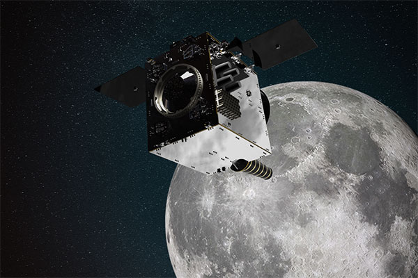
Artist’s impression of SSTL’s Lunar Pathfinder satellite that will provide communications services around the Moon. (Image: SSTL)
News from the European Space Agency (ESA)
ESA is going to the Moon — in collaboration with its international partners — and seeks to build a lasting lunar link to enable sustainable space exploration.
The agency has now evaluated initial ideas to create a network of lunar telecommunications and navigation satellites.
Creating a commercial telecommunications and navigation service for the Moon will allow many of the dozens of planned lunar missions to share the same infrastructure to communicate with Earth, as well as to find their way on the lunar surface.
The service is needed because the planned missions are becoming regular trips to Earth’s natural satellite rather than one-off expeditions.
Using a shared telecommunications and navigation service will reduce the design complexity and weight of individual missions, making them more cost-efficient.
Lowering the ticket price to lunar exploration could also empower a wider group of ESA member states to launch their own national lunar missions, inspiring the next generation of scientists and engineers.
Call for Ideas
The call for ideas for how to use a lasting link with the Moon is open until April 30. People working for commercial companies, universities or governmental organizations are welcome to suggest how they would like to use a lunar communications and navigation service.
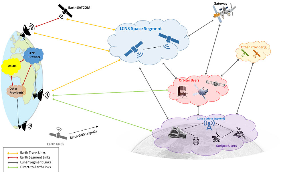
This diagram presents a notional preliminary top-level system concept for a lunar communications and navigation service. (Image: ESA)
Concept Reviews Completed
Two consortia of companies have now completed their system concept reviews, which set out how to create the lunar constellation, under ESA’s Moonlight initiative to identify the best way to create a lasting link with the Moon. The reviews set out the business and technical analysis needed to identify and justify a number of feasible system concepts for creating the lunar network.
The next step will be to define a detailed system architecture and identify the most suitable partnership models between private space companies and ESA.
Telespazio leads the first consortium. The consortium includes:
satellite operators Inmarsat and Hispasat
manufacturing companies such as Thales Alenia Space Italy, OHB System in Germany and Canadian space technology company MDA
Italian Aerospace Logistics Technology Engineering Company (ALTEC)
small and medium-sized enterprises such as Nanoracks Europe and Argotec
universities and research centers such as SEE Lab, SDA Bocconi and Politecnico di Milano.
The second consortium is spearheaded by Surrey Satellite Technology Limited, both in the service prime capacity through its lunar services brand SSTL Lunar and as the satellite manufacturer. The consortium includes:
satellite manufacturer Airbus
satellite network providers SES, based in Luxembourg, and Kongsberg Satellite Services, based in Norway
the Goonhilly Earth Station in the UK
British satellite navigation company GMV-NSL.
Artemis Program and Pathfinder
NASA’s Artemis program will use several of ESA’s service modules to return humans to the Moon, including the ESPRIT communications module for the lunar Gateway’s living quarters for astronauts. With its European industrial partner, ESA is helping to build the Lunar Pathfinder, showcasing lunar communications service provision by providing initial services to early lunar missions, including a complete lunar navigation in-orbit demonstration.
The Moonlight initiative builds on both the ESPRIT communications module and the Lunar Pathfinder.
Smith Myers showcased ARTEMIS, a mobile phone detection and location system designed specifically for airborne search and rescue (SAR) and disaster relief, at a helicopter trade show in Dallas.
The company, founded 35 years ago in the United Kingdom, also designed and developed software-defined radio and cellular protocol stacks designed specifically for the SAR role. According to the company, ARTEMIS turns any mobile phone into a rescue beacon, only requiring two antennas to generate a latitude/longitude fix at up to 19 nautical miles (35 km), offering an alternative to traditional airborne sensors.
ARTEMIS’s features include:
texting and calls in no service areas
possible automatic cueing of electro-optical/infra-red (EO/IR)
deployment as a stand-alone with embedded mapping or integration with mission system providers
making missions in low light / instrument meteorological conditions (IMC) safer and more successful and
availability in several SWaP configurations for manned/unmanned platforms.
Smith Myers announced in February that ARTEMIS has been integrated into the new Robotics Centre Echo SAR payload for small unmanned aerial systems (UAS) built by Teledyne FLIR Defense.
ARTEMIS airborne capabilities are available for use on manned rotary and fixed-wing platforms and drones with large and small payloads. It has already been in service with the AW101 Norwegian all-weather SAR helicopter and can be deployed across payload categories down to a small quad-rotor UAV.
A GNSS receiver is scheduled to land on the Moon in 2023, sent by NASA and the Italian Space Agency (ASI). The innovative GPS and Galileo receiver, provided by Qascom, will experiment with satellite-based positioning on the lunar surface.
The project, dubbed NEIL (Navigation Early Investigation on Lunar surface), is at the center of an agreement between ASI and NASA, linked to the CLPS 19-D mission (NASA’s Commercial Lunar Payload Service, Task Order 19).
The NEIL payload will be integrated into the Lunar GNSS Receiver Experiment (LuGRE), an ASI/NASA cooperation framework to develop activities in lunar and cislunar environments.
For the first time in history, GNSS positioning will be tested at almost 400,000 kilometers from Earth. The previous limit was a distance of 200,000 kilometers, tested in the Magnetospheric Multiscale (MMS) project.
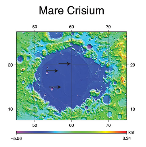
NEIL will be integrated on the NASA’s Blue Ghost lunar lander in 2022. In addition to the NEIL payload, nine other experiments will land on the Moon. The mission is expected to be launched via a SpaceX Falcon 9, and the lander with aim for the Mare Crisium basin.
Image: NASA/Resse Patillo
Moon-Hardened Receiver
Under an ASI contract, Qascom will develop the dual-frequency GPS and Galileo receiver, as well as the entire radiofrequency chain (antenna, LNA, filters), all of which can withstand the extreme environmental conditions of the Moon.
The GPS and Galileo signals received from NEIL will be extremely weak due to the distance from Earth, and will be processed with specific algorithms allowing to calculate position and time, even if with reduced accuracy, both during the Moon transfer orbit and on its surface.
Image: NASA
“This experiment is of strategic importance for Italy, since it will bring our technology to the Moon surface,” stated the Italian Space Agency. “It contributes to strengthening the competitiveness of the Italian space sector and consolidates the strong collaboration between the Italian Space Agency and NASA in the satellite navigation segment as well as in the future Moon and Mars missions.”
NEIL provides also an important technical and scientific contribution to study how GPS and Galileo could be used for positioning and timing in future Moon missions, including for example the deployment of lunar satellite constellations, lunar rovers, the lunar space station Gateway and the infrastructures that are going to be developed in the frame of Artemis programs. The raw measurement collected will be used by the research community to study the lunar and cislunar environment and evaluate the future use of GNSS to support permanent missions.
Soon, global navigation will no longer suffice. Humanity is preparing to return to the Moon after more than half a century. U.S., European, Chinese, Indian, Japanese and Russian governments and companies want a slice of the “eighth continent.”
NASA’s Artemis program, which aims to put astronauts on the Moon’s south pole in 2024, will explore more of the lunar surface than ever before. Robots and humans will search for, and potentially extract, resources such as water, which also can be converted into other usable resources, including oxygen and fuel.
Astronauts searching for spots where robotic spacecraft have pointed to the ice on the lunar map and for equipment sent on ahead of them will need precise navigation guidance. So will astronauts and ground controllers operating the Gateway outpost in Moon orbit and the Orion spacecraft. This will require extending the reach of our Earth-centric positioning, navigation and timing (PNT) systems to cover our planet’s nearest neighbor.
A permanent and reliable source of PNT on the Moon will reduce the amount of gear each mission will have to develop and carry, making more funding and rocket-lift capabilities available for scientific equipment. It also will free bandwidth on NASA’s communications networks, which have historically provided navigation services near the Moon.
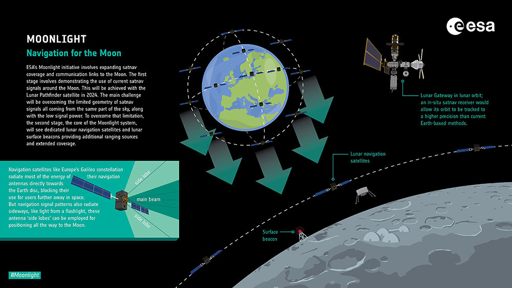
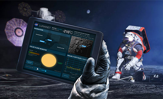
NASA and the European Space Agency (ESA) are laying the foundations for this navigation system. Their efforts include the development of a special receiver able to pick up GPS signals that, already very weak on Earth, are extremely so on the Moon; NASA’s LunaNet communications and navigation architecture; ESA’s public-private Pathfinder satellite navigation and communication mission, due to launch into lunar orbit by the end of 2023; and ESA’s Moonlight initiative, which will establish lunar communication and navigation services.
Studies already have proven that it is possible to navigate between Earth and the Moon, as well as on the latter’s surface, using the side lobes of the signals from GNSS satellites. In 2023, the Lunar GNSS Receiver Experiment (LuGRE), developed in partnership with the Italian Space Agency, will demonstrate and refine this capability on the Moon’s Mare Crisium basin. NASA will use data gathered from LuGRE to refine operational lunar GNSS systems for future missions.
Besides the low signal power, other challenges to using GNSS satellites for Moon navigation include geometry, with all the signals coming from a relatively small portion of the sky; the fact that in polar regions the Earth would be low on the horizon and therefore GNSS signals could easily be blocked by hills or crater rims; and the complete occultation of the signals when moving beyond the side of the Moon always facing Earth. Meeting this last challenge will require at least a couple of Moon-orbiting satellites. (Artificial satellites orbiting our planet’s natural satellite as a supplement to the artificial satellites orbiting our planet…)
The Moon will be our steppingstone to Mars. I bet it will not be long before the Institute of Navigation establishes a Planetary Navigation division!
Advanced Navigation, in partnership with quantum technology company Q+CTRL, will create a quantum-enhanced inertial navigation solution for space launch vehicles, satellites and landers. The design of this inertial navigation technology for long-endurance space missions will be pivotal to NASA’s space exploration initiative, the Artemis Lunar Exploration Program.
The work will be done under a Moon to Mars Supply Chain Capability Improvement grant by the Australian federal government.
The quantum-enhanced navigation system will enable NASA and its partners in the international space exploration community to execute deep space, lunar and planetary missions that were previously not possible.
Artemis is NASA’s human lunar exploration plan, with the program aiming to send the first woman and next man to the surface of the Moon by 2024. Scientists have long acknowledged the Moon as a rich source of information regarding Earth and the Solar System. Using the findings from the Moon. NASA will then prepare to launch missions to Mars.
To meet NASA’s space exploration initiatives, high-end, highly accurate inertial navigation technology is vital to the mission’s success. The groundbreaking inertial navigation systems developed by Advanced Navigation have been recognised by the international aerospace community as a superior technology to help pioneer a new age of space exploration and discovery for humanity.
For Advanced Navigation, this is just the beginning. “In the long-term view of this critical initiative, team activities following this project will establish an ongoing manufacturing opportunity and capacity that is central to the emerging Australian space industry,” said Chris Shaw, co-CEO of Advanced Navigation.
Advanced Navigation was founded in Sydney in 2012 by engineers Xavier Orr and Chris Shaw to commercialize thesis research into AI neural network-based inertial navigation. The first product met the market with great success and the company expanded rapidly adding a portfolio of navigation offerings and moving into a diverse range of deep tech fields such as underwater acoustics, GPS, radio frequency systems, sensors and robotics.
Today Advanced Navigation is a supplier to companies including Airbus, Boeing, Tesla, Google, Apple and General Motors. Advanced Navigation is headquartered in Sydney with a large research facility in Perth and sales offices around the world.
We leave as we came, and, God willing, we shall return, with peace and hope for all mankind.” —Astronaut Gene Cernan’s closing words, the twelfth and last person on the moon as he stepped back into the Apollo XVII Lunar Module on December 13, 1972.
Photo: NASA
Apollo was about vision, courage and discovery. Apollo helped unravel the mysteries of the moon — a serene, desolate, and barren place, bleached by the sun, and covered in a pale, gray, abrasive dust made up of microscopic, razor sharp, glass-like shards called regolith that is 60 feet deep in places.
Beneath the regolith is the bedrock of the moon — the Lunafirma.
The next phase of exploration is building a permanent base station on the moon, aptly named Artemis, Apollo’s twin sister. It would be fitting when mankind returns that the next person who steps out onto the lunar surface were a woman.
Artemis Moon Log/Program Entry Date 42: Earth Day is Tuesday, November 4, 2025
The regolith mining operations are proceeding as expected. All operations are 100% solar power until additional mobile thorium reactor units arrive. The only existing thorium reactor unit is the Clavius Crater water extraction operation. Construction of the Selene-1 Moonbase has encountered a setback. No other issues are reported.
The regolith in the surrounding plain is 6 meters deep. The Miners have not experienced any issues. The electrostatic power suits are repelling the abrasive dust better than expected. The Miners have cleared a 50 m2 area down to the bedrock. From the Gateway observation deck, it appears as a small square crater. The Miners are working non-stop on rotating shifts clearing regolith, recharging, replacing parts, or in transit.
Analysis of the regolith reveals a uniform distribution of 21% silica, 13% aluminum, 10% calcium, 10% iron, 5% magnesium, and 2% sodium and titanium. Minor amounts of chromium, phosphorus, and potassium are present. Hydrogen is 0.0027%. The metals are all oxides containing 40% elemental oxygen, which is being separated during processing for later use.
West about 200 km, towards Mare Crisium, the gravitational anomalies increase but within the Selene-1 Moonbase crater the anomalies are negligible. Geospatial analysis of the drill cores show an extensive concentration of lithium beneath a 12-meter-thick layer of basalt east of Ginzel Crater. Towards the south are increased concentrations of titanium and tungsten. Ejection debris discovered during the regolith mining operation showed traces of neodymium. The estimated trajectory of the ejecta points to it coming from the Moiseev Crater complex. An expeditionary rover is in route to collect samples and will arrive in 6 hours. Readings from those samples will be in the next log report.
The Parabolic Solar Powered (PSP) laser torches in the open crater basin are performing as expected. The Constructors are 3D fusing the regolith into silicate glass forms and transporting them to staging areas for later construction. The higher-than-normal content of iron in the regolith is giving the glass forms a reddish hue.
At the south pole, the water extraction operation at Clavius Crater has been operating uninterrupted for 816 hours. The thorium reactor is powering the entire operation. The smelter is distilling volatiles out of the regolith at the rate of 1m3 every 8 hours extracting a liter of water every 24 hours. The operation is on schedule for the two 100-liter tanks of water for delivery to the Selene-1 Moonbase by the due date.
There are five 4G cellular towers around the perimeter of the Selene-1 Moonbase and regolith mining area at 3 km intervals. The cellular array is providing accuracies of 1 millimeter allowing for precision mining, drilling, construction, and transportation. As the operation expands, more towers will be added. Two more towers are stationed at Clavius Crater. The 360° cameras and radar provide continuous surveillance and monitoring.
Testing of the 3D vision and synthetic neural response systems of the robots is complete and all of them are operational. The real-time connectivity with the robots allows controllers onboard the Gateway to remote link into any of the robots using virtual headsets and haptic body suits for full-immersion control. AI is constantly scanning for anything unusual and alerts the controllers to remote in; otherwise, the robots operate continuously and efficiently. The Miners are clearing nearly 5m3 of regolith every 24 hours during light conditions.
Phase I is underway. Miners are leveling off the exposed bedrock to begin construction of the landing pad. Once finished, the Constructors will use the PSP laser torches to begin fusing together the silicate glass blocks to make the landing pad. Afterwards, The Miners will begin Phase II and lay the foundation for the railgun to propel the filled mineral containers back to Earth. Both Phase I and Phase II are on schedule.
The setback encountered during construction of the Selene-1 main base station is due to excessive heat build-up. The Excavators are clearing the floors and shaping the walls within the lava tube. However, the heat from the laser torches is building-up and shutting down the machines prematurely. When the ambient temperatures exceed 160°C the machines shutdown to protect their electrostatic coatings. Having no atmosphere and no wind the heat is not dissipating. The fluid in the heat exchangers is overheating. Until directed otherwise, the Excavators are doing 90-minute shifts and the Torches for 35 minutes. The Torches have to fuse together the support beams and the silicate glass protective layering behind the Excavators to preserve structural integrity. A software update set the laser torches to pulse fire extending the heat build-up for an additional 5 minutes. Only 15 meters have been cleared but the inflatable habitats require at least another 85 meters into the lava tube. The setback pushes back the date for completing the base station by approximately 620 hours. A temporary external module can house the astronauts for their return on April 19, 2026 until Selene-1 is completed.
The above fictional account of a Moon Log entry for the Artemis program is based on NASA’s mid-October announcement selecting Nokia to build a 4G network on the moon.
An in-depth look at the announcement holds interest for the GIS community.
The Artemis program will be heavily dependent on spatial technologies and require a Lunar Spatial Reference System. However, the Moon has significant challenges. There is no constellation of satellites orbiting the Moon to provide precise location data like GPS satellites do on Earth, and it is not possible to develop such a satellite system around the moon because the moon’s gravitational center is lopsided and weighted towards Earth due to tidal lock. This causes orbital decay of lunar satellites until they eventually crash into the lunar surface.
However, there are four orbital inclinations that allow for indefinite low orbits and may provide for a future Lunar Positioning System (LPS). Such a system would be extremely costly, so a less expensive and more immediate LPS will be a ground-based cellular network array; and 4G is preferred over 5G because it offers longer ranges, which is why NASA selected Nokia. NASA is working on other solutions through the Space Communications and Navigation (SCaN) program.
Figure 2: Unified Geologic Map of the Moon. Orthographic projections of the “Unified Geologic Map of the Moon” showing the geology of the Moon’s near side (left) and far side (right) with shaded topography from the Lunar Orbiter Laser Altimeter. It will serve as a reference for lunar science and future human missions to the moon. Gravitational mass concentrations are also depicted in the image showing the majority being on the nearside while the farside is void of gravitational concentrations. Check out a video of rotating sphere. (Image: NASA/GSFC/USGS)
In a blow to science fiction novels, it will not be humans out on the barren, dust covered lunar landscape, or in the cold depths of crater shadows with pickaxes and jackhammers. It will be robots working prolonged periods in extreme temperatures running on solar power or nuclear power while constantly bombarded by cosmic rays and direct solar radiation.
Accomplishing this will require real-time communication with spatially enabled, artificially intelligent machines able to support fully immersive experiences with 3D vision headsets and haptic feedback systems so controllers at the base station wearing special suits can remote into any robot.
Due to a 2.5-second transmission delay between the Earth and the Moon, Ground Control will be limited to observation and analysis. Autonomous rockets will ferry cargo and supplies between more distant locations on the moon and ferry astronauts back and forth to the Gateway space station.
The ground-based 4G cellular towers will be mobile units with retractable towers about 25 meters high with a circular array of solar panels that will unfurl about 10 meters up from the base of the mast to protect them from the abrasive regolith dust.
Beneath the panels rovers and robots will plug in and charge their batteries as they journey to and from the base station. The towers will have 360° cameras and sensors and will provide data links and a localized spatial reference system.
However, objects in flight, such as autonomous rockets, will require other means to navigate across the moon and between the space-based cargo ships and the base station.
One solution is visual-inertial odometry (VIO). It uses one or more cameras and at least one inertial measuring device. Those components are already standard on almost every smartphone. Position accuracy using VIO is derived by feature recognition — the most prominent features on the moon are craters.
In support of this initiative, the National Geospatial Intelligence Agency (NGA) is sponsoring a software developer’s challenge to create algorithms for identifying circular patterns in imagery. It’s harder than you think. Learn more here.
Figure 3. (Photo: NASA/GSFC/Arizona State University)
The base station will be inside a lava tube beneath the moon’s surface to protect astronauts and equipment from solar radiation and micrometeor impacts. Most of the resources for the moon base will be extracted and processed in-situ, which requires spatial analysis of drill core samples to pinpoint where to mine for minerals in the subsurface layers and where to locate scarce resources such as water. The lava tubes on the moon are also valuable for mining operations but navigating an underground environment with autonomous machines poses challenges of its own, some of which are spatial awareness. The Defense Advanced Research Projects Agency (DARPA) recently held a developer’s challenge to address navigating in subterranean domains.
“Reaching the Moon by three-man vessels in one long bound from Earth is like casting a thin thread across space. The main effort, in the coming decades, will be to strengthen this thread; to make it a cord, a cable, and, finally, a broad highway.” —Isaac Asimov
William Tewelow works for the Federal Aviation Administration. He is a graduate of the FAA management fellowship program. He served on special assignment to the U.S. Department of Transportation leading a national strategic geospatial iniative for the White House Open Data Partnership. He is a Geographic Information Systems Professional and a speaker for the Maryland STEMnet Scholar program. He was among the first in the nation to earn a Geospatial Specialist Certification from the U.S. Department of Labor while working at NASA Stennis Space Center. He has degrees in Geographic Information Technology, Intelligence Studies and is completing a masters degree in Organizational Management. William is a 23-year veteran for the U.S. Navy serving as a geospatial specialist, imagery intelligence specialist, a naval aviator, a meteorologist and a tactical oceanographer. He is married, enjoys writing and traveling. His favorite quote is, “A man’s mind changed by a new idea can never go back to its original dimension.” —Oliver Wendell Holmes
Honeywell, under a contract with Lockheed Martin, will supply guidance and navigation systems for NASA’s upcoming Artemis missions, which will fly humans to the moon for the first time since 1972.
The companies are supplying key components to NASA’s Orion spacecraft fleet for the Artemis missions. Components include the barometric altimeter, the inertial measurement system, and the GPS receiver.
Honeywell will provide 14 product types for Artemis missions III through V, including both hardware and software solutions, to support NASA’s lunar missions. NASA awarded Lockheed Martin a long-term, multibillion-dollar production contract for the Orion spacecraft, aimed to meet the space agency’s anticipated needs into the 2030s.
Working in collaboration with the Orion team over the next decade, Honeywell will support Lockheed Martin and its partners through the development and production of essential guidance and navigation systems, command data handling, and display and control products. The focus of the missions is to conduct science and learn lessons that will help take humans to Mars.
Honeywell will supply the following types of technology for the Artemis missions:
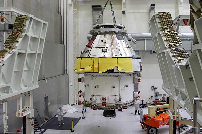
First Orion Spacecraft: In this March 30 photo, Orion I is moved to the Final Assembly and Systems Test cell at Kennedy Space Center. The spacecraft returned from Ohio after a successful series of environmental tests at Glenn Research Center’s Plum Brook Station. (Photo: NASA)
• Guidance and Navigation Systems. Key navigation and guidance solutions, including the barometric altimeter, which tracks the altitude of the Orion capsule in Earth’s atmosphere, as well as the inertial measurement system (INS) and GPS receiver, which track the position and movements of the capsule.
• Command Data Handling. Several data-handling products, including the vehicle management computer, which acts as the central computing platform supporting flight and vehicle control, as well as spacecraft communication functions.
• Displays and Controls. Three display units and struts, seven control panels, and two hand controllers used inside the spacecraft to help astronauts in the Orion capsule monitor and control the vehicle.
• Core Flight Software. Includes the integrated modular avionics software, a key system responsible for supporting maintenance functions sharing flight data information.
The contract to supply key components of the Orion crew module and service module is being managed and performed out of Honeywell’s facility in Clearwater, Florida. Work is also being conducted at the company’s facilities in Glendale, Arizona, and Puerto Rico.
Honeywell was part of NASA’s previous crewed space missions, including those that took humans to the moon.