Tag: auto navigation

  • Network RTK for Intelligent Vehicles

    opener

    Accurate, Reliable, Available, Continuous Positioning for Cooperative Driving

    By Scott Stephenson, Xiaolin Meng, Terry Moore, Anthony Baxendale, and Tim Edwards

    Adoption of network real-time kinematic GNSS positioning can lead to major improvements in vehicle localization, although implementation must overcome some real-world challenges. This article assesses the extent of GNSS signal outage in a motorway environment. The average total GNSS outage period and the average time to resolve ambiguity for the network RTK solution can help assess complimentary sensors for a ubiquitous positioning system.

    Real-time vehicle localization is one of three key enabling technologies for the concepts of vehicle-to-vehicle and vehicle-to-infrastructure (V2V and V2I, collectively termed V2X, see opening graphic), a classification of intelligent transport systems (ITS). The further enabling technologies are ad-hoc dynamic networking of agents, and accurate dynamic local traffic maps. Jointly, these require that positioning be accurate, reliable, available, and continuous.

    A natural evolution in road transport, V2X promises to deliver the next major safety breakthrough. The concept moves away from vehicles making individual decisions about road safety, as in advanced driver assistance systems, and towards a cooperative driving approach that shifts the emphasis from collision protection to collision prevention. The U.S. National Highway Traffic Safety Administration  estimates that V2X technology can avoid or minimize up to 80 percent of collisions of unimpaired drivers, and that even a small number of deployed vehicles will provide tangible safety benefits.

    Network RTK GNSS positioning, like V2X applications, requires a communication system; and by its nature V2X has a positioning solution requirement. Thus it is envisioned that network RTK will play an essential role in the implementation of V2X systems. The consensus between car manufacturers and research organizations is that the future of V2X communication lies with Dedicated Short Range Communication (DSRC) devices, and a large pilot study is currently under way. However, in the short term many V2X applications could be achieved using existing technology, such as cellular communication, offering a legacy solution, and initiating early uptake of V2X applications.

    Previous research by the Nottingham Geospatial Institute (NGI) at the University of Nottingham showed that network RTK positioning can provide a high-accuracy positioning solution during real-world trials, but also revealed two areas of concern: the loss of the fixed-integer ambiguity during satellite line-of-sight outages; and the fragility of the data communications service that delivers the real-time correction information. During road tests, a fixed-ambiguity network RTK solution was available for less than 50 percent of the time on United Kingdom (UK) roads.

    Network RTK Vehicle Positioning
    Figure 1  OS Net reference station network in Britain, owned by Ordnance Survey.
    Figure 1. OS Net reference station network in Britain, owned by Ordnance Survey.

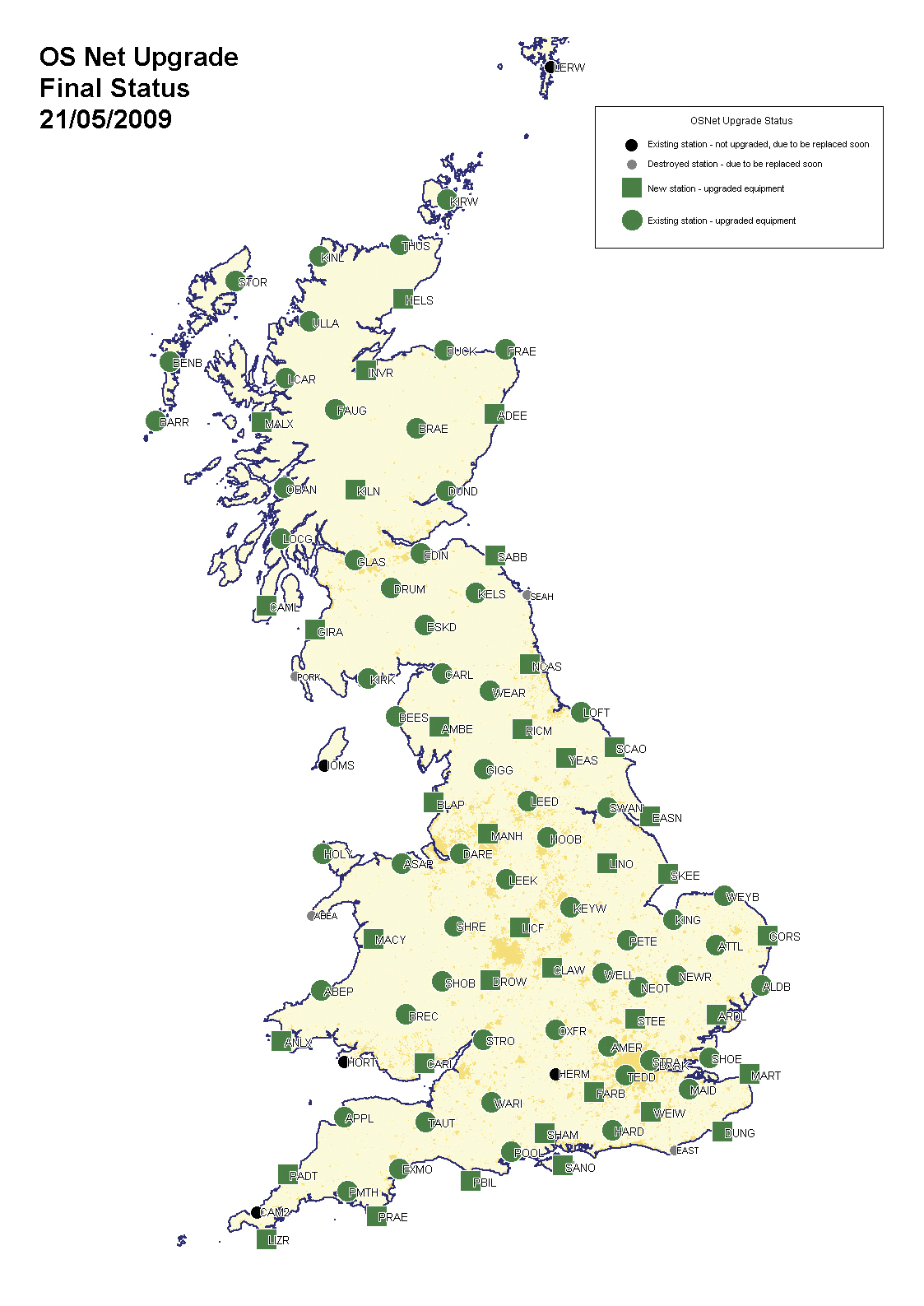
    Networks of continuously operating reference stations (CORS) extend across Europe, North America, Australia, and East Asia. Networks vary in size from five or six reference stations for agriculture to systems of hundreds of CORSs providing national or regional service. Figure 1 shows the location of the OS Net CORS run by Ordnance Survey in Great Britain.

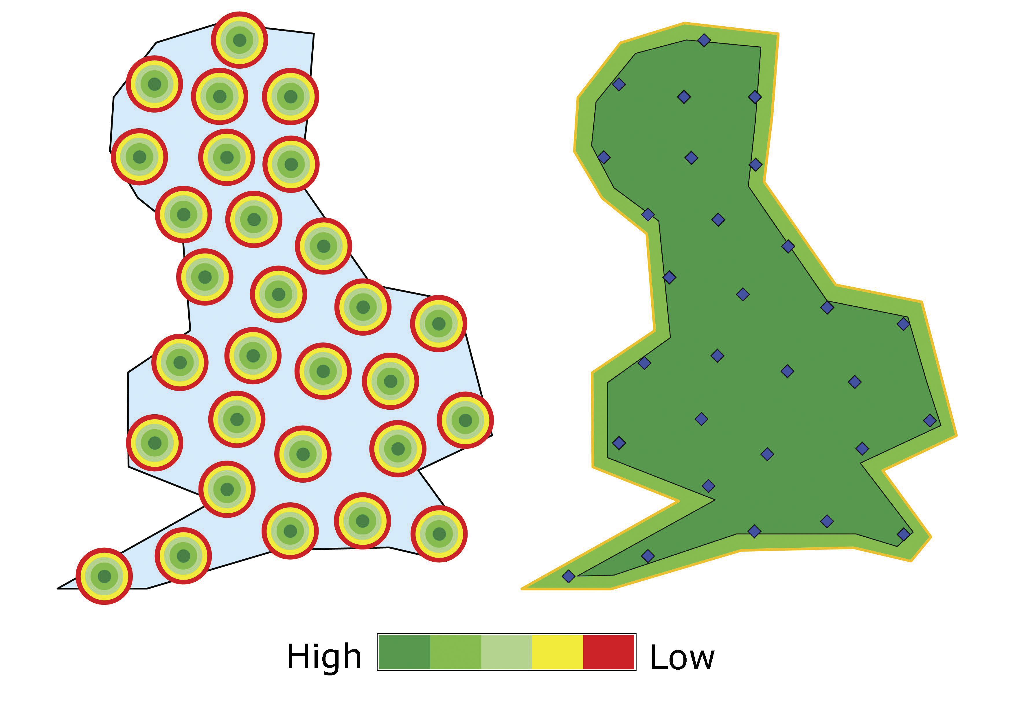
    Figure 2 shows the main advantage of network RTK as compared to traditional RTK. The individual reference stations on the left suffer from the spatial decorrelation of errors as distance between reference and rover receivers increases. Adequate vehicle positioning would require individually operating reference stations to be placed approximately 20–30 kilometers apart. However, a CORS network can be used to develop a model of differential corrections, as shown at right, from which a rover receiver can interpret RTK correction information and use this during the computation of its position. The geometry of a CORS network allows two adjacent reference stations to be located up to 80–100 kilometers apart without degrading the accuracy, although in practice most systems tend to locate them closer together than this. This is essentially a reduction from 30 reference stations per 10,000km² for conventional RTK, to 5–10 reference stations for network RTK, delivering high-precision services to virtually unlimited users.

    Figure 2  The improved navigation performance from RTK (left) to network RTK (right).
    Figure 2. The improved navigation performance from RTK (left) to network RTK (right).

    It is expected that the CORS networks will become a critical part of a country’s spatial infrastructure, and countries like the UK are leading the way. This makes network RTK one of the most promising positioning technologies for road vehicles and ITS applications.

    As shown in previous research, network RTK can deliver a vehicle positioning accuracy of better than 5 centimeters, and in real-world tests this level of accuracy had an availability of 41–45 percent, depending on the environment. It was also found that the correction information was available via the GSM network for more than 80 percent of the time. In these same tests, the total time without any GNSS position solution (network RTK, DGNSS, or stand-alone) was up to 16 percent in a motorway environment. Network RTK was able to provide lane-level positioning accuracy, but the sensitivity of the technique to GNSS signal loss and coverage of the communication network had a significant effect on availability. GNSS outages could be caused simply by passing under a road bridge, and the network RTK solution would be lost, although there would continue to be a DGNSS solution for a short period. Finding effective solutions to these current barriers, which prevent wide adoption of network RTK, is a key enabling step for ITS.

    Accuracy Assessment

    In much more controlled tests to assess the accuracy of network RTK on a dynamic vehicle, the network RTK GNSS receiver was compared to an inertial navigation system (INS). This test was carried out using the NGI roof laboratory, which houses a 120-meter rail track running an electric locomotive.

    Both the network RTK receiver and the INS used the same antenna, fed separately through a signal splitter. The network RTK solution was recorded in real time onto an SD card in NMEA GGA format. The INS data was recorded and post-processed in a tightly coupled solution using a continuously operating dual-frequency GNSS receiver base station located inside the rail track circuit. There were no recorded GNSS outages as there is a clear-sky view from the roof laboratory.

    The antenna point was also tracked using a total station, recording observations at 10 Hz stamped with GPS time. Although the accuracy of the tracking mode of the total station is not high enough to assess the accuracy of the network RTK solution (because of time synchronization issues), it ensures that any gross errors in GNSS observations that could affect both the network RTK and INS solutions did not occur.

    The results in Table 1 show that the network RTK solution consistently performs to a high accuracy, giving a low standard deviation from the mean in all directions. Listed are three laps of the rail circuit recorded at different times. There are a small number of epochs that encounter large differences of more than 200 millimeters, such as during laps 2 and 3, although these appear to be very short-term anomalies, possibly caused by dynamic GNSS signal multipath or delays and message loss in the communication system.

    TABLE 1.  Comparison of the tightly coupled (GPS+IMU) solution with the N-RTK solution.
    Table 1. Comparison of the tightly coupled (GPS+IMU) solution with the N-RTK solution.

    The worst absolute accuracy is shown during lap 3, although even in this case, with a mean of 21 millimeters and 99 percent of the observations lying within 15 millimeters, this solution still delivers a solution within 36 millimeters of the ground truth. 50 percent of the network RTK observations are within 1 millimeter of the mean difference between the two solutions, showing remarkable consistency and precision.

    Challenge: Comm Signal Strength

    A fundamental aspect of network RTK is the delivery of reference station data used in the processing of the receiver’s position. Although there are various methods used to deliver this data, the most secure and reliable method involves transmitting raw reference station observations, so that the receiver may perform the calculation of the position with all possible data. This provides the highest integrity. The vulnerability here is not the algorithmic method used to transmit the data, but the communication system, in three ways:

    • There is no connection between reference and rover receivers.
    • There is data loss from the connection.
    • There is an unacceptable delay in the transmission of the data.

    Lack of Coverage. The preferable communication system is to use mobile Internet over the GSM/GPRS cell network, which is already well established. The major network operators claim over 99 percent coverage of the population in the UK, but this does not take into account physical and local conditions such as land and building obstructions, atmospheric conditions, and inter-ference from vegetation and other
    radio signals.

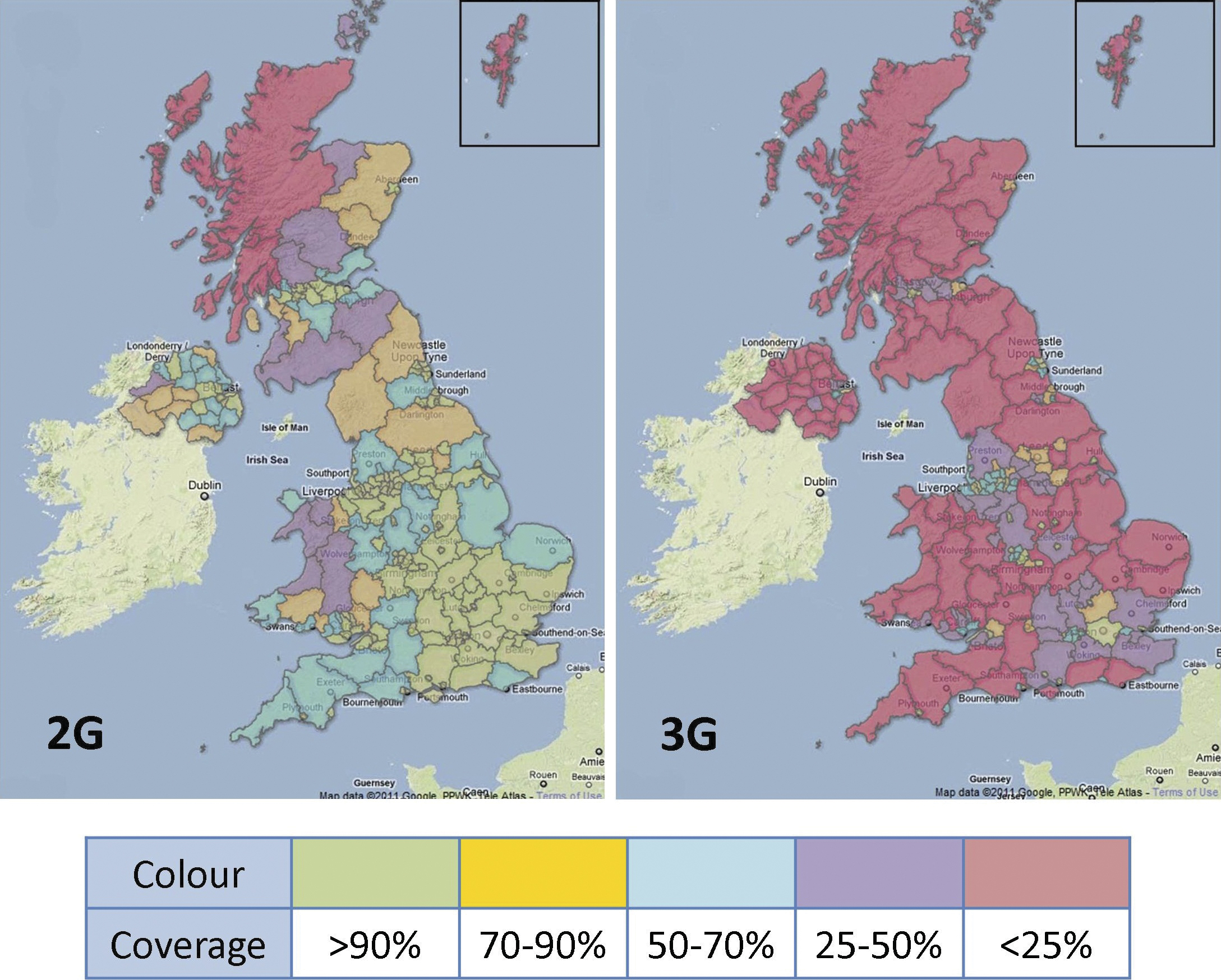
    A 2011 BBC survey in the UK found that when users had a cell-phone data connection it was 3G for 75 percent of the time (2G otherwise), but significant “notspots” include major rail and road networks. An ongoing study by OpenSignalMaps has found that a 3G service is only available 58 percent of the time. A 2011 government report detailed the extent of 2G and 3G services, shown in Figure 3. Areas with poor data communication coverage (below 50 percent) pose a significant problem for network RTK in vehicles.

    Figure 3 2G (left) and 3G (right) coverage by geographic area in the UK: green, >90 percent; yellow, 70–90 percent; blue, 50–70 percent; purple, 25–50 percent; red, <25 percent.
    Figure 3. 2G (left) and 3G (right) coverage by geographic area in the UK: green, >90 percent; yellow, 70–90 percent; blue, 50–70 percent; purple, 25–50 percent; red,

    Data Loss. Continuity tests show that when using GSM/GPRS mobile communications to transfer the network  RTK corrections, the availability was approximately 88 percent, and the connection could be lost after a few hours of continuous use. This can be caused either by SIM cards that use dynamic IP addresses, creating interruptions when renewing the addresses, or where voice data was prioritized on the network. Other research has shown that a typical mobile Internet connection (a combination of wired public Internet and GPRS) suffers from approximately 20 percent data loss.

    Message Delay. A network RTK receiver  imposes a transmission time limit on the correction messages that are used to fix the common integer ambiguity (in this case, the Leica GS10 limit is 10 seconds), although messages younger than 60 seconds can be used to give an accurate DGNSS solution. Messages older than 60 seconds result in the receiver only being able to output a standalone position, by which time the accuracy will decay beyond vehicle positioning requirements. Earlier research found the typical mobile Internet connection suffers from an average delay of 0.85 seconds.

    Challenge: GNSS Outages

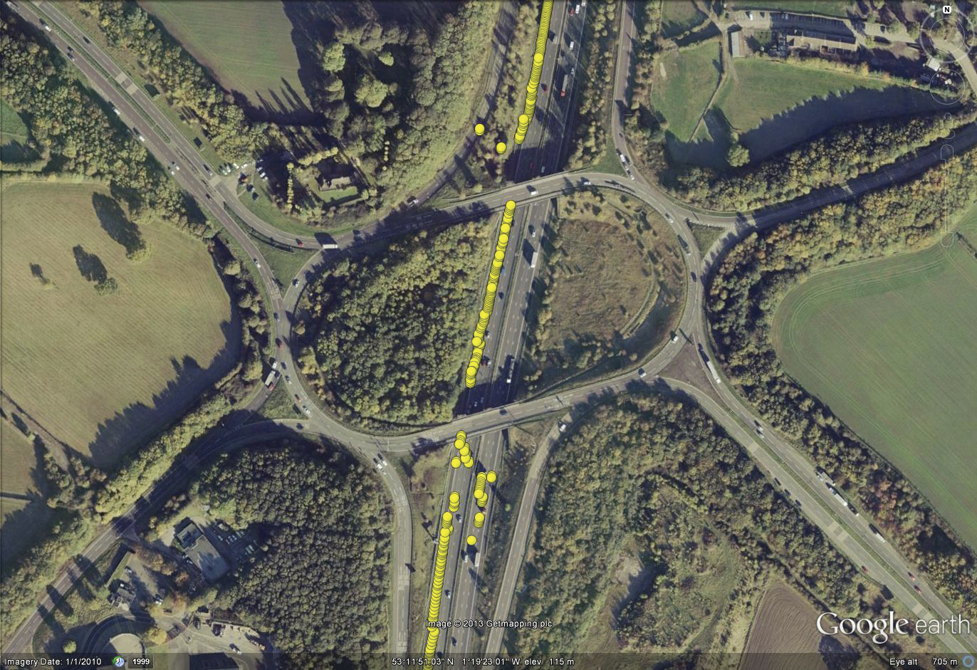
    The majority of the transport infrastructure is outside and has a clear view of the sky, particularly away from heavily urbanised areas. However, the receiver gets no warning of impending signal obstruction, so that even momentary obstructions such as an overhead gantry on the motorway can cause significant loss of positioning accuracy, and often causes a receiver to output no solution at all, as shown in Figure 4. Here the vehicle is traveling in a northern direction in lane 1 of the left-hand carriageway and passes underneath a series of bridges at a motorway junction. This causes both GNSS outages and deteriorated positional accuracy, so much so that the vehicle is positioned in the southern carriageway (note that the underlying map image is of unknown accuracy).

    Figure 4  The typical effect of overhead obstructions on vehicle GNSS positioning.
    Figure 4. The typical effect of overhead obstructions on vehicle GNSS positioning.

    GNSS outages can occur in several ways: the obstruction of the GNSS signals can lead to a loss of signal lock; a momentary obstruction or partial obstruction can cause cycle slips to occur (during carrier-phase positioning); if the visible satellites at the rover receiver are not the same as at the reference receiver, then the ambiguity cannot be resolved; there may be intentional or unintentional signal jamming or interference; and if the receiver assessed the integrity or accuracy to be poor then it may not provide a solution.

    NGI test vehicle.
    NGI test vehicle.
    Experiment Set-Up

    The test vehicle was equipped with a GNSS receiver and antenna, receiving real-time corrections using a GSM/GPRS connection. The signal strength was measured simultaneously using the Android application RF Signal Tracker on an Android-based mobile phone.

    The data recorded includes: GNSS raw data, RINEX format; network RTK real time output, NMEA format; GSM signal strength, CSV format. As the experiments were not intended for the analysis of the accuracy of the GNSS receiver, there was no need to utilize the ground truth system onboard the NGI test vehicle.

    RF SIGNAL TRACKER Android application and mobile phone used to record the GSM signal strength (left), and GNSS receiver (right).
    RF SIGNAL TRACKER. Android application and mobile phone used to record the GSM signal strength (left), and GNSS receiver (right).

    Test Environment. Two test scenarios were chosen for the experiments. To assess the GNSS signal outages, the test vehicle was driven along the M1 motorway, a length of approximately 100 kilometers. The M1 is a major road transport artery linking London in the South to Leeds in the North of England, typically with three or four lanes in each direction. This route passes under 214 overhead obstructions (northbound and southbound directions), of known classification (gantry, footbridge, road bridge). This scenario was chosen as the environment is quite rigid, allowing repeatable tests, and it is the area in which future ITS technology is most likely to be adopted first.

    To test the variation of GSM signal strength in real-world conditions, a small circuit was chosen close to the Nottingham Geospatial Institute (shown in Figure 5), which incorporates a variety of environments from open sky to bridge underpasses, and dense tree coverage. Using a repeatable path allows the identification of issues that are attributable to problems with the communications link as opposed to other issues (such as hardware problems and GNSS signal outages), and despite the short distance, the loop also provides a wide range of GSM signal strengths. During the experiments to follow, the data was measured during three consecutive laps of the circuit.

    Experiment Results

    GSM Signal Strength. The variation in color along the NGI test route is an indication of the RSSI (Received Signal Strength Indicator). In this area, the RSSI varies between –50 dBm and –105 dBm, which are the typical maximum and minimum strengths of a cellular network. This is despite the assessment from the network provider that this entire area delivers high-speed Internet and email. Figure 5 also shows the subjective rating and expected performance of the RSSI.

    Figure 5  The GSM signal strength around the NGI circuit in Nottingham, with the subjective RSSI ratings.
    Figure 5. The GSM signal strength around the NGI circuit in Nottingham, with the subjective RSSI ratings.
    Table2
    Table 2. The spread of RSSI observations recorded during the trials around the NGI circuit.

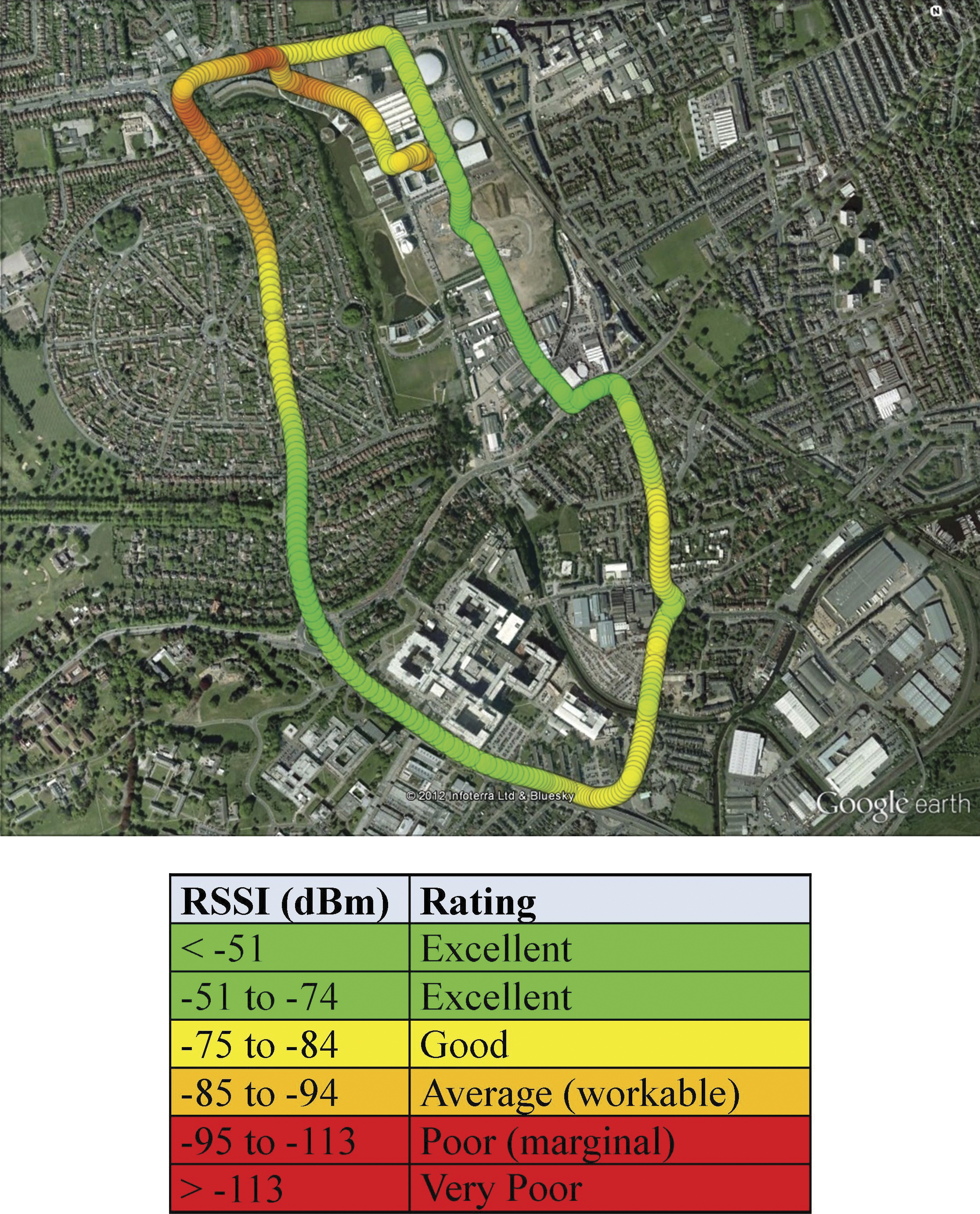
    Table 2 details the RSSI observations measured during the signal strength trials around the NGI circuit. The range of values shows the typical maximum and minimum RSSI values experienced by a cell-phone user (other than no signal being received). The signal strength is recorded every 5 meters, in order to achieve a good geographic spread across the area (as opposed to biasing the results with observations recorded whilst the vehicle is stationary). The RSSI observations do not correspond to a typical Gaussian distribution, suggesting that there are external influences on the strength of the signal and the handover between one cell tower and the next.

    Figure 6 shows an increase in the age of correction (AoC) of the messages following a drop in signal strength (RSSI) to approximately –100 dBm. This is visible from the peaks in the age of correction message to over 8 seconds. The graph shows three laps of the NGI circuit, noticeable by the repeated pattern of signal strength. The increase in the AoC occurs at approximately the same geographic location on each lap ­— an area in the northwest of the circuit that suffers from weak signal strength, as seen in Figure 5. The received signal strength is the sum of the direct and indirect (or reflected) waves, varying with distance between a series of maximum and minimum values. On a moving vehicle, the RSSI will vary with time as it moves between these maximum and minimum values, and is especially complicated in urban areas where there may be no direct waves at all, and waves are propagated by a series of reflections. A moving receiver also suffers from a Doppler shift in the received signal’s frequency.

    figure 6  The effect of GSM RSSI on the age of correction messages.
    Figure 6. The effect of GSM RSSI on the age of correction messages.

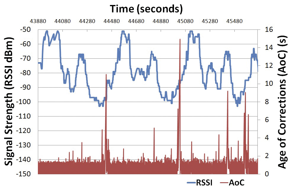
    During network RTK positioning, the receiver considers messages older than 10 seconds unusable for a fixed network  RTK solution, although messages younger than 60 seconds can be used to give an accurate DGNSS solution. This scenario has a brief occasion during the loop in which loss of the network RTK solution is attributable to weak GSM signal strength.

    A close inspection of Figure 6 highlights a slight delay between the drop in RSSI to –100 dBm and the increase in the AoC. This delay needs further analysis, but is assumed to relate to the slower update rate of the ionospheric and tropospheric corrections (10 seconds and 60 seconds respectively). There are also periods of increased AoC that are uncorrelated with a drop in RSSI, for which there is no clear explanation, although none of these occasions results in a loss of the fixed ambiguity network RTK solution.

    Eighty cell handovers were recorded during the trials, which is higher than average as this area is liable to carry a large volume of cellular traffic (there is a university, a large hospital, and major roads, as well as general housing and business properties). The cell handovers showed an average improvement of +1.2 dBm from just before the handover until just after. The maximum improvement is +22 dBM, although there are occasions when the RSSI gets worse, the biggest fall in received signal strength being –12 dBM. Figure 7 displays the frequency distribution of the change in RSSI during a cell handover. The resolution of the RSSI measurements is 2 dBm.

    figure 7  Frequency histogram of the RSSI change during a cell handover (2 dBm bins).
    Figure 7. Frequency histogram of the RSSI change during a cell handover (2 dBm bins).

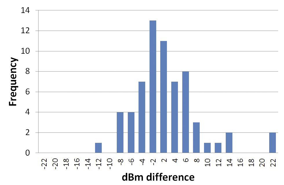
    Cell handovers occur at a range of RSSI, not just low signal strength. This suggests that cell handovers are managed by the network operator in a way that does not disrupt the data connection. There appears to be no correlation between a cell handover and a problem with the correction message delivery.
    Although this part of the experiment was not a test of receiver performance, during the NGI circuit trial 63.1 percent of the receiver observations were network RTK fixed, and 33.0 percent of the observations were DGNSS observations. Therefore, 3.9 percent of the possible epochs had no observations, partly due to passing under bridges. The largest GNSS outage during circuit trials was 4.85 seconds. These values show an improvement over previous research, particularly as this is considered a difficult GNSS positioning environment.

    GNSS Outages. During the GNSS outages tests, the vehicle traveled at a constant speed of 60 mph, mostly in lane 1 of the motorway. Table 3 shows statistical breakdown of the GNSS outages and the resulting reacquisition of the fixed ambiguity in network RTK positioning.

    Table3
    Table 3. Statistical breakdown of GNSS outages caused by overhead objects.

    The longest total GNSS outage caused by an overhead obstruction was 4.65 seconds, when passing under a road bridge. At 60 mph this translates into a distance of almost 130 meters without any GNSS solution, which is much further than the width of the overhead object. Once the GNSS signal is reacquired, there is a short period during which the fixed integer ambiguity is resolved, in order to achieve the centimeter-level accuracy. The longest duration between start of a GNSS outage and reacquisition of the fixed ambiguity for the network  RTK solution is 52.10 seconds, or 1,450 meters. Although during this period, a DGNSS solution is available as soon as the satellites are reacquired.

    Discussion

    Nationwide adoption of cellular Internet services by cell phone users has provided a useful communication system for positioning systems. But network providers do not guarantee the type of communication service demanded by advanced ITS and V2X applications. The quality of service is too easily disrupted by passing into an area with weak signal strength, or when many users congest the bandwidth.

    Future generations of cell networks, such as 4G, will significantly increase the available bandwidth and increase download speeds, but there is an unknown increase in the demand on the system from non-critical cell-phone users. The issues in the existing system can be minimized slightly through improvements at the user end, such as using stronger gain antennae or accessing multiple networks with different SIM registrations. The nature of cell networks also leads to a decrease in signal strength occurring prior to the cell handover, which can cause delays in the message delivery, so the management of this process could be improved. Future testing of the GSM network can be carried out at the new innovITS ADVANCE test facility at MIRA in the UK, where the private network can be controlled and manipulated as desired.

    An alternative communication method, that has the same wide area coverage of a cell network, is satellite communication. In tests, observation of static positions showed 98 percent of messages were received correctly at a latency of less than 10s. This compares with the High-Speed Download Packet Access (HSDPA) cell network figures of 99.8 percent and 1.2s. When in a kinematic mode, the satellite communications fared less well. Testing three separate satellite communication systems, problems were encountered with reacquisition, long latency, and static initialization. At best, 70 percent of correct messages were received, with a latency of 4.2s, although often over 20s.

    Digital Audio Broadcasting (DAB) is capable of being used as a future communication method for network  RTK positioning. Compared to traditional VHF and UHF radio communication, it uses the frequency more efficiently and is more robust to degradation.

    The design of the GNSS receiver used in testing is aimed at delivering a very reliable and highly accurate solution. It was not intended for use on vehicles and in dynamic environments. The receiver deals well with multipath, rejecting low-strength GNSS signals, allowing the resolution of the integer ambiguity. However, this means that in city environments it may provide fewer solutions than a modern smartphone, albeit with a much higher accuracy when it does. Recent research shows it is possible to increase the speed of ambiguity resolution, and customize integrity controls, making the resolution process close to instantaneous in certain circumstances.

    Conclusions

    As cellular communications networks evolve in the UK and other countries, the performance of the network  RTK receiver also improves. We found that once the RSSI drops to approximately –100dBm, the correction messages suffer from either message loss or message delay that causes the receiver to underperform. The performance of the communication link during a cell tower handover has shown that there is no deterioration in the performance linked to the handover, although cell tower handovers generally occur at the limits of a cell tower’s coverage, and hence at low signal strengths.

    The resolution of the fixed integer ambiguity is crucial for the high-accuracy solution available with a network RTK receiver. The resolution is relatively fast, typically within two minutes from a cold start, or fewer than 20 seconds from a hot start. During tests on the M1 motorway, passing under an overhead obstruction caused a maximum total GNSS outage of 4.65 seconds, and a maximum time until the ambiguity was resolved of 52.10 seconds. On average, the GNSS outage was 1.14 seconds with an average re-fix time of 13.13 seconds. Until the ambiguity is resolved, the receiver can continue with a DGNSS solution delivering lane-level accuracy.

    Manufacturers

    NGI’s inertial nav system is an Applanix POS/RS, which consists of a NovAtel OEM4 dual-frequency GPS receiver combined with a navigation-grade Honeywell consumer IMU. The network RTK position was provided by a Leica GS10 receiver and Leica SmartNet correction service over the Vodafone network. Both receivers used a Leica AS10 antenna.


    Scott Stephenson is a Ph.D. student at the Nottingham Geospatial Institute within the University of Nottingham.

    Xiaolin Meng is associate professor, theme leader for positioning and navigation technologies, and MSc course director for GNSST and PNT at the Nottingham Geospatial Institute of the University of Nottingham. 

    Terry Moore is director of the Nottingham Geospatial Institute (NGI) at the University of Nottingham, where he is the professor of satellite navigation and also an associate dean within the Faculty of Engineering.

    Anthony Baxendale is head of Advanced Technologies & Research at MIRA Ltd.

    Tim Edwards is the lead engineer of the Intelligent Transportation Systems (ITS) research group at MIRA Ltd

  • u-blox 3G module certified by Korean’s SK Telecom

    u-blox, the Swiss positioning and wireless chip and module company, has received approval for its LISA-U110 UMTS/HSPA wireless module from SK Telecom, Korea’s largest mobile telecom operator with more than 50 percent market share. SK Telecom provides multimedia services and connectivity to 24 million customers throughout South Korea.

    The certification allows the LISA modem to be used in a wide range of consumer and M2M applications operating over SK Telecom’s nation-wide 3G network including vehicle infotainment, supply chain management, industrial automation, metering, security, and location-based services.

    “We are very pleased that SK Telecom has chosen to work with us on this 3G approval. Our compact and high-speed LISA 3G module is a perfect fit with their strategy to provide converged wireless services supporting entertainment, business and financial applications. Our local support in Korea was a key factor in obtaining this certification” said Samuel Ji, u-blox Country Manager, Korea.

    The LISA-U110 is an embedded wireless UMTS/HSPA module delivering high data rates in 3G networks intended for consumer, automotive and industrial applications. For telematics applications, the series provides easy integration with u-blox GPS, GLONASS and QZSS receivers.

    LISA modules come in SMT form factor and have a very small footprint, allowing easy mounting on any application board. The LISA form factor enables easy manufacturing, u-blox said, as well as simple migration from u‑blox’ GSM/GPRS modules. Support for A-GPS and u-blox’ CellLocate positioning technology is embedded to facilitate advanced telematics applications including indoor positioning.

    Features include compatibility with quad-band GPRS/EDGE, low power (idle mode less than 2 mA) and operating temperature -40 to +85 deg. Celsius. RIL software for Android and Embedded Windows is available free of charge.

    LISA modules are manufactured in ISO/TS 16949 certified sites and are fully qualified according to ISO 16750 — Environmental conditions and electrical testing for electrical and electronic equipment for road vehicles to provide high durability and reliability.


  • Researchers Use Traffic App Data to Identify Accident Hotspots

    Researchers at Israel’s Ben-Gurion University of the Negev (BGU) say reveal that data culled from geosocial networks like the GPS traffic app Waze can help prevent traffic incidents with better deployment of police resources at the most accident prone areas.

    “Only now are we beginning to discover the potential in the huge amount of data collected daily,” explains BGU researcher and Ph.D. student Michael Fire. “Studies of this kind, which monitor events such as traffic accidents over time, can help the police identify dangerous sections of roads in real time, or alternatively, locations where few police are needed.”

    The paper, “Data Mining Opportunities in Geosocial Networks for Improving Road Safety,” was presented at the IEEE 27th Convention of Electrical and Electronics Engineers in Israel.

    Waze records location data and enables users to upload and share comments on any detail, including traffic alerts, accidents or police presence. According to its website, Waze has 30 million worldwide users and describes itself as “a community-based traffic and navigation app whose users share real-time traffic and road info, saving time and gas money.”

    Using Waze data and Google Earth, the BGU researchers determined that three-quarters (75 percent) of the locations in Israel with the highest number of accidents were intersections. They then analyzed references to a police presence to determine if the police were present at the spots that had the worst traffic accidents.

    “There were numerous instances where the police were manning quieter intersections, while busier intersections went unmonitored,” Fire explains.  “According to the data, police response time varied from 20 minutes to 40 minutes in some situations.”

    Using Waze, data from May and June 2012 was collected and analyzed on accident reports, police presence, traffic jams, and speed traps. BGU researchers identified 579 different locations in Israel that had at least five reoccurring accidents during this time where 5,156 reported accidents occurred. Police were reported at least 15 times at more than 3,500 locations.

    Other researchers involved with the study from BGU’s Department of Information Systems Engineering and BGU’s Telekom Innovation Laboratories include Prof. Yuval Elovici, head of the lab, as well as Dr. Rami Puzis, Prof. Lior Rokach as well as student Dima Kagan.

  • Trimble, ng Connect Collaborate on Connected Service Vehicle Demo

    Trimble’s ThingMagic Mercury6 (M6) RFID Reader will be part of the ng Connect Program’s Connected Service Vehicle, which showcases a full suite of cloud-based services designed to deliver office productivity to vehicle-based workers. In this concept vehicle, the ThingMagic reader will be used to support work-order based inventory management and tool tracking applications to illustrate aspects of a typical service visit.

    The ng Connect Program, founded by Alcatel-Lucent, is a multi-industry ecosystem dedicated to the creation of the new generation connected user experience. ng Connect is comprised of more than 190 Contributing and Associate member companies including network, consumer electronics, application and content providers. Twelve proof of concept demos will be featured this year in the Alcatel-Lucent CES booth at the 2013 Consumer Electronics Show, January 8-11, in Las Vegas.

    As a collaborating member of the ng Connect program, Trimble is providing the development platform for in-vehicle RFID solutions and sensor technology for high-volume commercial, industrial and enterprise applications. Achievements in the automotive market include receiving the Ford World Excellence Award for contributions to a first-to-market RFID-enabled solution designed to help contractors track and manage their tools.

    “We’re honored to join the ecosystem of innovative, market-shaping companies in the ng Connect program,” said Bernd Schoner, vice president of business development at Trimble’s ThingMagic Division. “Using the vehicle as the basic point of data capture can enhance productivity. Uploading asset information from the vehicle to a central data aggregation layer for anywhere, anytime consumption by a variety of applications is the future.”

  • Agero Unveils Auto Infotainment Development Kit

    Agero Connected Services has announced the development of the AgeroView DevKit, a new cross-platform toolkit designed to accelerate the deployment of cloud-based automotive infotainment system applications. The DevKit includes specialized APIs (Application Programming Interfaces) and associated support to enable access to a variety of in-vehicle platforms ranging from safety and GPS positioning to multimedia and climate control.

    The DevKit, which will include an application software development kit (SDK) as well as a hardware evaluation kit, will be evaluated by select automakers during the first half of 2013 before its release.

    According to Agero, the launch of the AgeroView DevKit will remove significant barriers that constrain today’s in-vehicle infotainment systems. Until now, infotainment system features have always remained relatively static over the course of the vehicle’s lifetime. With the DevKit, automakers and developers can deploy more exciting and convenient experiences even years after the vehicle is sold. Drivers and passengers will be able to personalize their device interfaces on demand, and dealers will have the opportunity to introduce new content and interfaces.

    The AgeroView DevKit will allow the deployment of far more efficient and practical applications, particularly those involving navigation, messaging, and safety/diagnostics. Motorists will receive  the added value created by the vehicle’s ever-improving array of functions, content, and service offerings.

    “With the AgeroView DevKit, automakers will now be able to target the applications critical to their brand and quickly deliver a user experience that builds brand equity,” said Frank Hirschenberger, Agero’s senior director of Innovation. “Moreover, the DevKit lets developers create apps with a simple, easy-to-learn interface that takes into account evolving knowledge on minimizing driver distraction.”

    The AgeroView DevKit also provides the critical portal between Agero’s AgeroView in-vehicle cloud services and the in-vehicle electronics. The DevKit makes it simple for developers to write and validate production-ready, automotive-centric apps through the use of standard Web technologies, the company said.

    The AgeroView DevKit resides as a component in the AgeroView cloud platform developed by Agero in partnership with M-Way Solutions, GmbH. The platform gives automakers and vehicle owners the flexibility to substitute providers of specific content such as navigation, entertainment, and news as well as customize graphic and audio interfaces whenever desired.

  • TI’s Wi-Link 8Q Provides Wireless Connectivity for Auto Infotainment

    Wireless connectivity is becoming a key feature in automobiles for sharing and viewing content from smartphones and tablets to in-car systems, easy pairing of devices, navigation and replacement of expensive cables for in-car communication. To answer this need, today Texas Instruments Incorporated (TI) introduced the WiLink 8Q family of wireless automotive connectivity solutions.

    “GNSS technology combines GPS and GLONASS signals with the on-chip positioning engine producing a more accurate fix of your location, making “urban canyons” non-existent,” according to the TI Behind the Wheel blog. TI is demonstrating WiLink 8Q and other technologies at the Consumer Electronics Show this week in Las Vegas.

    With its multi-radio technology, the WiLink 8Q family reaches new levels of cross platform scalability and delivers advanced features including in-car multimedia streaming video in parallel with Bluetooth hands-free calling and advanced audio distribution profile (A2DP) stereo sound. Additionally, with near field communications (NFC) for easy Wi-Fi and Bluetooth pairing, WiLink 8Q solutions enable an easy connection between a smartphone or tablet and the automobile, providing a seamless user experience, according to TI.

    The WiLink 8Q family is designed for Wi-Fi Certified Miracast operation. With an integrated power amplifier (PA) and complete software reuse across all family members, WiLink 8Q solutions provide a full range of products for wireless automotive infotainment including:

    • Super-combo SoCs with Wi-Fi, Bluetooth, Bluetooth low energy, NFC, and GNSS support.
    • Combo-connectivity system-on-chips (SoCs) with Wi-Fi and Bluetooth support.
    • More integrated combo-connectivity SoCs with Wi-Fi, Bluetooth, Bluetooth low energy and NFC.

    “Delivering the familiar experience consumers have with smartphones and the tablets into the automobile to share information and content from drivers’ and passengers’ devices is driving the need for strong wireless connectivity solutions. Wi-Fi, Bluetooth, NFC and GNSS have to work together seamlessly as integrated parts of the entire system,” said Mattias Lange, automotive connectivity product line manager, Wireless Connectivity Solutions, TI. “The WiLink 8Q family takes our expertise in wireless connectivity and automotive applications to the next level with support of four different RF technologies on one SoC – a truly integrated approach to automotive infotainment.”

  • Trimble Acquires Transportation Company ALK Technologies

    iphone-RenaultApp .Credit: ALK Technologies
    ALK Technologies CoPilot Live software enables OEMs to bring own-brand turn-by-turn navigation apps to market.

    Trimble has announced that it has acquired privately-held ALK Technologies Inc. of Princeton, New Jersey. ALK Technologies specializes in routing, mapping, mileage and navigation technologies. ALK Technologies offers proprietary routing and international map-based solutions for transportation, logistics and mobile workforces.

    The addition of ALK is expected to extend and complement Trimble’s Transportation and Logistics product portfolio, including TMW Systems’ transportation management solutions, PeopleNet’s integrated onboard computing and mobile communications systems, and GEOTrac’s fleet management and worker safety solutions for the oil and gas industry. Financial terms were not disclosed.

    ALK software products include CoPilot Live, which offers onboard GPS navigation for professional drivers, and PC*MILER, a truck-specific mileage solution recognized as an industry standard for logistics, manufacturing, government and transportation operations. ALK offers a consistent data platform for operational planning activities, such as mileage and routing and in-cab navigation applications used by fleet drivers. ALK products are sold worldwide and feature extensive international map data. Approximately 64 percent of North American for-hire motor carriers use ALK solutions, including 98 of the top 100 largest for-hire carriers, 47 of the top 50 logistics companies and 77 of the top 100 private fleets.

    “The addition of ALK Technologies expands the portfolio and scope of innovative solutions we can offer transportation providers, logistics companies and shippers,” said David Wangler, president of TMW Systems, a Trimble Company. “The combination of ALK’s routing, mapping, mileage and navigation capabilities with our enterprise transportation management software and the mobile communications solutions under the Trimble Transportation and Logistics umbrella supports our comprehensive and industry-focused technology approach.”

    “This is a significant milestone in ALK’s long history in transportation,” said Barry Glick, president of ALK Technologies, who will continue to lead the organization. “We are excited to join our well-known and respected partner TMW Systems under the global umbrella of Trimble. These organizations share our passion and vision for how location information can transform business and productivity.”

    ALK Technologies business will be reported as part of Trimble’s Mobile Solutions segment.

  • CE-Traffic Launches Premium RDS-TMC in Poland

    CE-Traffic, a traffic data provider in Central-Eastern Europe, has extended its portfolio of traffic services in Poland, the country where over last five years the number of vehicles has grown by 50 percent. Drivers in Poland can look forward to more options in receiving real-time traffic information with the launch of the new Premium RDS-TMC service by CE-Traffic, the company said.

    “We looked at TMC solution with all its limitations and asked ourselves: how we can get more out of the technology that has been around for more than a decade so that navigation systems vendors can offer to their customers an easy-to-implement and affordable traffic service of a real value? Our Premium RDS- TMC offers drivers an access to very detailed traffic information without any mobile telecommunication cost and subscription fees,” said Jiri Novobilsky, CEO of CE-Traffic.

    Competitive advantage of CE-Traffic Premium RDS-TMC is based on smart use of TMC components, according to CE-Traffic. Up-to-date traffic flow data and journalistic information are smartly aggregated and regionally filtered. CE- Traffic TISA certified Location Table (LTN 6) offers the best available coverage. It includes not only all major roads and streets but also lower category roads commonly used by drivers like shortcuts or alternative routes. RDS channel with enhanced capacity allows broadcasting high number of traffic messages (over 1,000). The service is available country-wide thanks to partnership with Radio ZET – leading Polish radio station.

    Tomasz Przeździęk, CE-Traffic director for Poland, added: “When looking at overall traffic offering for personal and in-car navigation systems in Poland one can see that expensive connected devices did not achieve the major market acceptance. Proven TMC standard together with high quality CE-Traffic Floating Car Data is an easy to implement alternative to provide drivers with the most accurate and up-to-date traffic information.”

  • Public Transport ITS Market in Europe Expected to Reach €1.5B by 2016

    According to a new research report from the analyst firm Berg Insight, the market value for Intelligent Transport Systems (ITS) deployed in public transport operations in Europe was €0.76 billion in 2011. Growing at a compound annual growth rate of 15 percent, this number is expected to reach €1.5 billion by 2016. Berg Insight is of the opinion that the European market for ITS for public transport is in a growth phase which will last for several years to come.

    In a statement, Berg Insight said the fluctuating economic climate has in most countries had little effect on the market as the public investments which underpin a major part of the ITS initiatives have remained stable throughout the periods of crisis. The vendor landscape for public transport ITS consists of a variety of actors. The companies INIT, Trapeze Group and IVU have emerged as leaders in Europe, having broad product portfolios and large numbers of installed systems in many countries. There are also local players with considerable market shares on regional markets in Europe, including Ineo Systrans and Vix. Another group of vendors are focused on specific parts of complete ITS such as specialized hardware units or software applications.

    ”The public transport ITS market in Europe is favored by several concurrent developments, including UITP’s sought-after doubling of the public transport ridership, the EBSF EU project, and generally higher expectations among travelers,” said Rickard Andersson, telecom analyst, Berg Insight. “Increasingly sophisticated solutions for traffic management and passenger information are available which – if implemented correctly – eventually can put public transport on par with private transportation modes in terms of traveling times and flexibility.” Andersson adds that a noteworthy development is the increasing integration of smartphone-based solutions in public transport ITS, used for various traveler-centric applications as well as business performance overviews for operators, and most recently also as affordable tracking solutions enabling real-time passenger information (RTPI). “Travelers increasingly expect real-time information also from smaller operators with low propensity to invest in ITS,” concluded Andersson.

  • Taxi Booking App Comes to U.S.

    myTaxi, a taxi booking smartphone application, today launched in Washington, D.C., its first introduction into the U.S. marketplace. The announcement was made during a live-streaming press conference given directly in a moving taxi.

    myTaxi was first launched in Germany in June 2009. It connects 2.3 million users to more than 18,000 taxis worldwide. Today marked the first time consumers in the U.S. will have access to the app. myTaxi’s services offer consumers a personal, transparent and convenient way to travel with features such as:

    • Peer-to-peer connection between driver and passenger, including driver photos, information and phone numbers.
    • A ratings system for selecting and reviewing your taxi driver and a favorites list to save your favorite drivers for future pickups.
    • Live tracking of taxi approach on display including arrival time, fare calculator, distance and automatic positioning via GPS.
    • View of every myTaxi in the area on the taxi radar.
    • myTaxi Payment – a direct billing process in the taxi via smartphone.

    “Americans took more than 10 billion trips on public transportation last year,” said Niclaus Mewes, co-founder and CEO, myTaxi. “Smartphones can have an immense impact on urban mobility. At myTaxi we want to rethink and reshape how taxi trips are taken. Passengers and drivers want something convenient, transparent and tailored to their needs. We want to deliver on that.”

    Every driver using myTaxi has the ability to become a contractor and build their own client base by consistently providing passengers with good service and earning high customer ratings. myTaxi offers a driver-side version of its app allowing taxi drivers to efficiently monitor the locations of customers and receive basic information on each customer once an order is placed.

    “The DC Taxicab Commission welcomes any electronic reservation company such as myTaxi, bringing technological advancements to the District of Columbia,” said Ron Linton, DC Taxicab Commission Chairperson. “We are delighted that passengers using DC public vehicles-for-hire will enjoy the enhanced quality of service.”

    During its press conference, myTaxi outlined a voucher system that will be provided to the app’s early adopters. The voucher campaign is one of the many programs and features myTaxi will continue to roll out in the D.C. marketplace. myTaxi will also bring new payment facility into the D.C. taxi market. The implemented feature “myTaxi Payment” provides users with the ability for cashless, card-less payments on all myTaxi rides by registering a credit card to their account. The myTaxi application is available in stores for free download to iOS and Android devices.

  • Rand McNally GPS for RVers Includes Weather, Rear-View Camera Capability

    Photo: Randy McNally GPS
    Photo: Randy McNally GPS

    Rand McNally today introduced the RVND 7720, a 7-inch RV GPS device with Wi-Fi connectivity allowing for real-time weather information and display, and new hardware with rugged casing, video input, and brighter screen.

    The new device — shipping now to stores, online retailers, and RV dealers and distributors — joins Rand McNally’s line of RVND GPS devices for RVers. Rand McNally pioneered RV-specific navigation by launching the first GPS device designed specifically for RVers and campers, the company said.

    RV-specific navigation is necessary to route large vehicles and towables around road restrictions, low bridges and other physical hazards. However, like all Rand McNally RV GPS devices, the RVND 7720 can be used as a car GPS by changing a simple setting.

    One of the key new features of the RVND 7720 is Wi-Fi connectivity, which enables the transmission and display of weather as well as other real-time information. With updated weather information, RVers will be able to anticipate delays and make plans by viewing current and predicted conditions displayed on the map and along the route, the company said. Besides weather, other RV-specific connected services will be coming soon for this device.

    The RVND 7720 has a new hardware platform as well, with a rugged design with ridged casing for added protection, a brighter screen that adjusts for low and strong light, and video input compatible with a range of back-up and rear-view cameras, Rand McNally said.

    The base maps and overlaying content, such as campgrounds, parks, RV service and other RV points of interest, also have been updated for the RVND 7720.

    The new device ships with Lifetime Maps, so owners will be able to update their devices at no additional cost.

    The RVND 7720 GPS includes the following additional new features:

    • Fully updated road data, including RV-specific information such as speed limits, legal and physical restrictions, and all Rand McNally proprietary RV data
    • Fully updated points of interest necessary for safe and convenient routing, including travel centers and RV parking information at rest stops, exits, and other locations
    • Fuel logs, which are accessible from the Virtual Dashboard or via RV Tools; the feature enables drivers to record fuel purchases for a trip
    • Additional routing options such as “Avoid State or Province” and “Avoid Smaller Roads”
    • Address book icon enhancement, which enables unique icons to be created by group and shown on the map for imported locations; address book items can be sorted by name, distance from current location or date added
    • Text-to-speech alert details for user-imported custom points of interest, such as red light cameras, to reduce driver distraction

    The RVND 7720 also has these features: Virtual Dashboard; junction view with lane assist; free downloads of Rand McNally’s proprietary construction information and software updates; Exits Quick View, which shows RV parking and amenities at exits; RV Tools, RV amenities and locations such as campgrounds, RV services, and dumps; Woodall’s Campground information with searchable amenities; Rand McNally exclusive pre-planned trips with photos and video; and routing for 11 types of RVs as well as for cars.

  • Toyota, Denso Develop Device for Real-time Vehicle Data Collection

    Toyota Motor Corporation and DENSO Corporation are jointly developing an on-board communications network device, CAN-Gateway ECU, that can take data gathered while driving and apply it to create a virtual simulation that enables a new way to enjoy driving.

    The CAN-Gateway ECU captures driving data — including GPS data, accelerator pedal strokes, steering angles, brake operation signals, gear shift signals, engine rpm count, water temperature, and vehicle speed — from a dedicated on-board GPS as well as CAN information exchanged among on-board ECUs. The device can wirelessly transmit (by Bluetooth) the data to software installed on smartphones or other devices for real-time monitoring. As this data is accumulated, it can serve as a driving coaching guide.

    Furthermore, software makers can use the data to create games or a wide variety of other software using standard creation tools, with no need to deal with the complicated nature of the onboard CAN protocol.

    The CAN-Gateway ECU can be fitted to the Toyota “86” rear-wheel-drive compact sports car. It is scheduled to be tested in Japan in spring 2013 by people active in car racing, before the scheduled Japan launch at the end of 2013.

    Further development is under way to enable vehicle data from drives on major circuits in Japan such as Fuji Speedway to be recorded onto USB flash drives for input into the racing game Gran Turismo, a PlayStation 3 home entertainment console title. Driving scenarios can then be recreated with the data and run simultaneously with other data to enjoy real-time, side-by-side track-run comparisons. Additionally, the user can reproduce aspects of a drive on a circuit such as the steering path taken, and where and when the brakes and accelerator were used, in the game for analysis and critique.

    USB memory data format and Bluetooth transmission protocol will be finalized after Toyota and DENSO review feedback with Polyphony Digital Inc., Densan System Co., Ltd. and other software makers, taking their expertise into account before specifications are finalized. Following this, information necessary for connecting to the CAN-Gateway ECU will be gradually made available to other software makers, DENSO said, thereby allowing for even broader development of software that explores new ways of enjoying cars.