Russian acts targeting critical infrastructure, satellite signal interference paralyzing maritime and air navigation, and cognitive operations aimed at intimidating European societies are examples of Russian hybrid activities targeting the Baltic Sea region states.
The paper, “White Paper on Russian Acts of Sabotage and Subversion against Members of the Council of the Baltic Sea States,” can be downloaded here. Authors Filip Bryjka, Anna Maria Dyner and Aleksandra Kozioł are with the Polish Institute of International Relations.
The report explores GNSS signal disruptions in the Baltic Sea and how it affects the safety of maritime and air traffic.
Scale and Methods of Russian Operations
Since the beginning of the full-scale invasion of Ukraine, Russia has intensified its hybrid activities against NATO member states, particularly those that have most actively supported Ukrainian resistance. This group includes the members of the Council of the Baltic Sea States. It is against them that the vast majority of acts of diversion and sabotage recorded in Europe since February 2022 have been directed.
Russia deploys a full spectrum of tools against the region:
Acts of diversion and sabotage targeting critical infrastructure.
Border incidents: Violations of airspace and maritime borders.
GNSS signal disruptions (satellite radio transmissions), creating operational problems for maritime and air navigation.
Cognitive influence, aimed at causing measurable damage, testing state responses, and inducing a sense of growing threat among societies.
Recommendations: How to Counter Hybrid Threats?
The offensive nature of Russian actions demonstrates an intent to destabilize NATO and EU countries. Effective defense requires developing shared mechanisms:
Close cooperation among agencies: Ensuring a high level of situational awareness through the coordination of activities (at both national and international levels) among military and civilian intelligence, counterintelligence, border guard services, and the police.
A dedicated information exchange system: Leveraging the geographical proximity and potential of the CBSS states to quickly share threat data.
Unambiguous attribution of persuasions: Publicly naming Russia as the author of the attacks. A lack of clear attribution hinders coordinated preventive and retaliatory measures.
A catalog of best practices: Developing common rules for monitoring, reporting, and responding to known and repetitive Russian operational patterns.
The authors conclude that only a full spectrum of coherent measures taken by all states in the region, alongside NATO and EU structures, can effectively influence Russia and reduce the risk of future incidents.
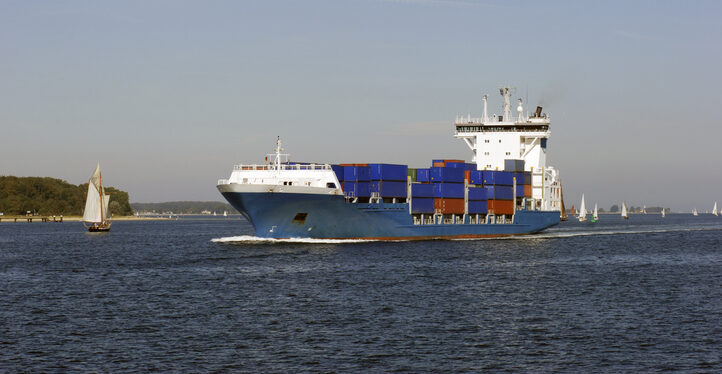
The Coastal States of the Baltic Sea and the North Sea have published an open letter to the international maritime community insisting on the protection of GNSS-based navigtion. The countries point the finger squarely at the Russian Federation for causing disruption in both critical navigation and timing services for sea vessels.
“Modern maritime transport is fundamentally built on the reliability of satellite-based navigation,” reads the letter. “For over three decades, global shipping has advanced by developing vessel operations to increasingly depend on the position, timing and navigation data provided by satellite systems. This shift has brought great efficiency but has also created a new dependency.
The letter highlights the importance of GNSS as a critical safety requirement, not only ship navigation but also precise time synchronization vital for systems such as the Global Maritime Distress and Safety System (GMDSS).
Risks to the Automatic Identification System
Another GNSS service, the Automatic Identification System (AIS), plays a key role in traffic coordination, situational awareness and emergency response. “Spoofing or falsifying AIS data undermines maritime safety and security, increases the risk of accidents, and severely hampers rescue operations,” the letter states.
“We are now facing new emerging safety situations due to growing GNSS interference in European waters, particularly in the Baltic Sea region. These disturbances, originating from the Russian Federation, degrade the safety of international shipping. All vessels are at risk.”
The countries ask for cooperation developing alternative terrestrial radionavigation systems as a GNSS backup. They also want vessels crews properly trained to operate safely during navigation system outages.
“Maintaining trust in maritime navigation requires more than technology – it demands responsibility, transparency, and decisive action,” the letter states. “We must ensure that our seas remain safe, including when systems fail or face disturbances.”
Shipborne Measurements Near the Kaliningrad Border
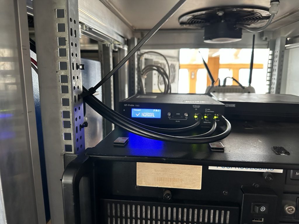
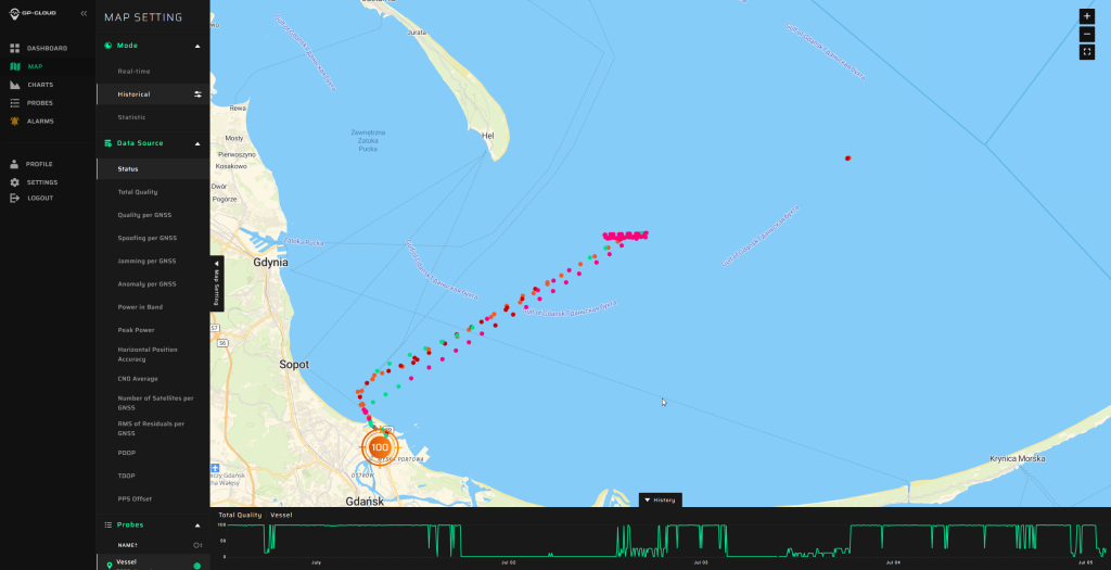
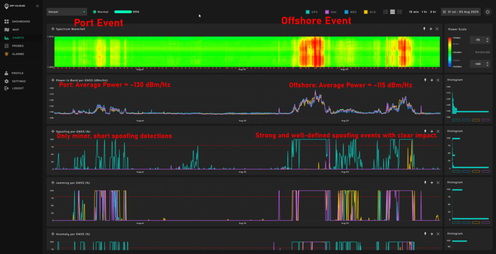
A major new report by GPSPATRON gathered data between June 23 and Oct. 14, aboard a vessel routinely leaving the Port of Gdańsk and performing extended maneuvers in open water.
The vessel conducted multiple offshore measurement campaigns, resulting in a shipborne dataset that provides a far more accurate representation of the true GNSS environment experienced by maritime operators in the Gulf of Gdańsk. It also reveals a level of interference complexity and intensity not visible in a previous coastal study.
In the present phase of research, the GPSPatron team moved beyond land-based monitoring and installed itsGP-Probe TGE2 interference sensor directly on board a research vessel. The ship operated throughout the southern Baltic Sea, including regular approaches toward the maritime boundary of the Kaliningrad region.
By placing the sensor on a moving platform rather than a coastal location, they were able to record GNSS interference exactly as it affects real vessels — capturing signal conditions that cannot be observed from shore due to differences in radio horizon, antenna orientation, multipath environment, and proximity to potential interference sources.
The GPSPATRON probe TGE2 instaslled within the vessel’s equipment. (Photo: GPSPATRON)
Transition from classical jamming to combined spoofing-jamming interference
In contrast to the previous six-month coastal study, where all recorded GNSS interference consisted exclusively of multi-constellation jamming, the current shipborne campaign reveals a fundamentally different interference landscape.
All major events now present a dual-layer structure composed of:
GPS L1 spoofing, generating forged satellite-like signals, and
Simultaneous jamming of GLONASS, Galileo, and BeiDou.
This combined architecture forces GNSS receivers to rely solely on spoofed GPS signals while denying access to independent ranging sources. The practice is consistent with commonly used operational strategies: spoofing only one constellation (GPS) drastically reduces system complexity and cost, whereas spoofing all GNSS systems would require multiple parallel RF chains, SDR-based generators, algorithms for signal simulations and amplifiers.
Highest recorded levels of GNSS disruption
The most severe interference period occurred from late June through July, during which:
GNSS availability dropped to 83.5%,
4 days, 5 hours and 24 minutes of spoofing were recorded — by far the highest cumulative spoofing activity of the entire campaign.
The single most extreme incident took place between 1 and 3 July, with nearly 30 consecutive hours of spoofing within a 48-hour interval, posing a severe risk for maritime navigation.
In subsequent months the interference intensity gradually decreased, yet low-power and short-duration events continued to be observed.
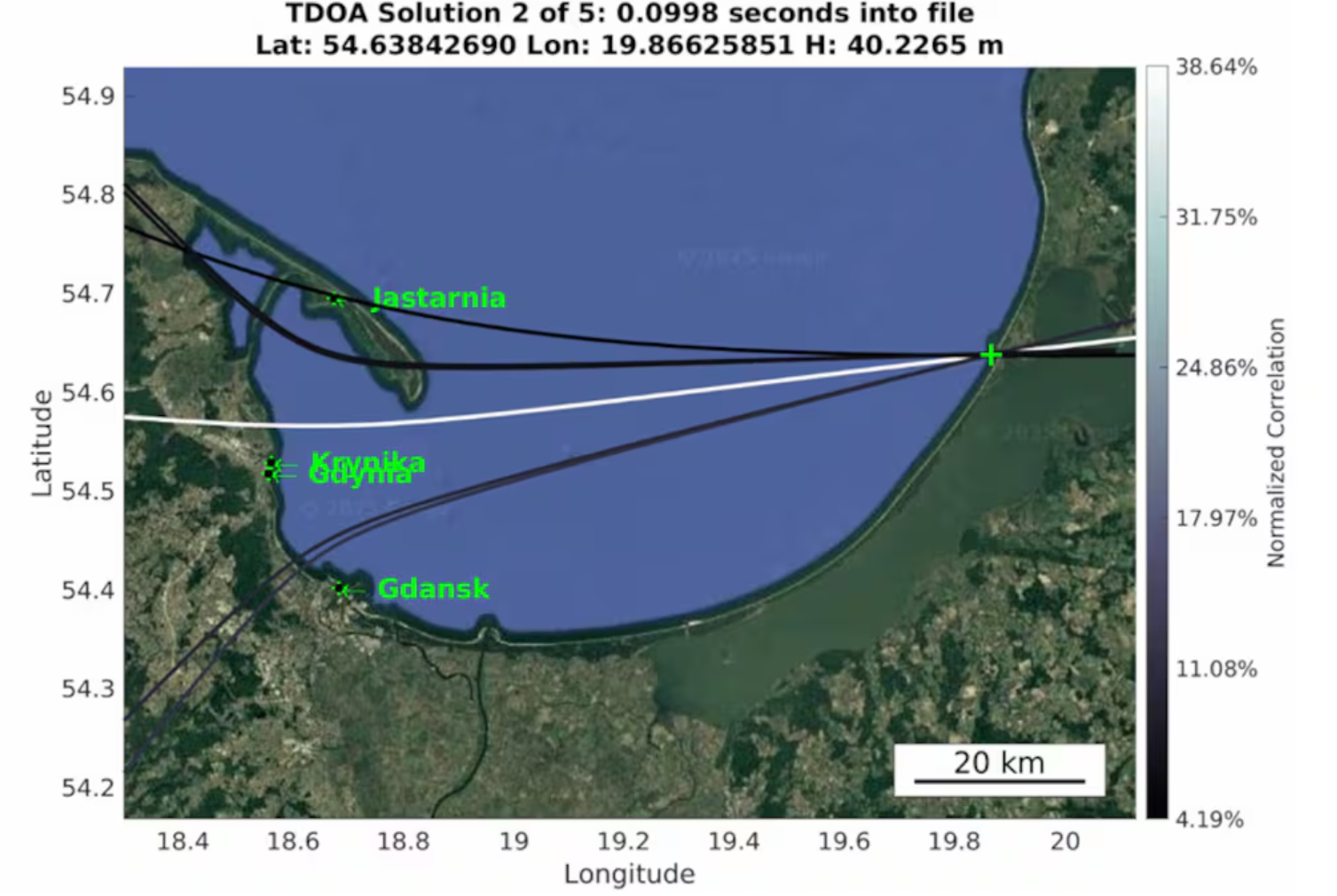
The area of the Baltic Sea the vessel patroled for GNSS interference. (Image: GPSPATRON)
A multi-emitter, synchronously operating interference network
Spectrogram analysis reveals that the interference does not originate from a single source but from four distinct, technologically different emitters operating in coordination:
The synchronous activation and termination of all four components indicate a centrally coordinated system, yet their differing spectral signatures, bandwidths, and stability levels confirm multiple spatially separated stations rather than a single unified installation.
This GNSS interference analysis shows interference intensity increases away from port. (Image: GPSPATRON)
Evolution of interference modulation techniques
A clear shift is observed compared to the previous study :
Previously, the dominant interference source consisted of a high-quality, purpose-engineered wideband signal with three clean constellation-matched components — an indication of modern, precisely designed jamming equipment.
In the current campaign, the prevailing interference is simpler wideband chirp jamming, a less advanced technique but deployed at significantly higher power levels.
The wideband analog-like component further shows pronounced parasitic frequency fluctuations, characteristic of older low-stability RF hardware.
This indicates a shift from high-precision jamming to a mixed environment of legacy high-power systems combined with newer spoofing capabilities.
Interference strongly intensifies offshore
A distinct spatial gradient was recorded:
In the Port of Gdańsk, interference appears weak or barely detectable.
As the vessel moves into open water, the same signals become up to 15 dB stronger.
The interference power consistently increases when approaching the waters facing Kaliningrad.
This pattern shows that — intentionally or not — the interference system affects maritime traffic far more than coastal infrastructure, with the operational impact being greatest in offshore navigational zones.
Download the full report using the form on this page.
The European Commission plans to expand its drone wall on Europe’s eastern borders because some regions said they felt left out after an initial “wall”, reports Reuters. The idea is to counter drone incursions with a network of sensors, electronic jamming systems and weapons stretching from the Baltic states to the Black Sea.
The European Drone Defence Initiative proposal is included in the commission’s Defence Readiness Roadmap 2030 issued Oct. 16. Commission President Ursula von der Leyen proposed the drone wall after 20 Russian drones entered the airspace of EU and NATO member Poland in September.
Eastern European states welcomed her proposal, but countries in southern and western Europe said it neglected drone threats in their part of the continent.
Combines airborne and ground-based GNSS interference monitoring in a single integrated system for unified situational awareness.
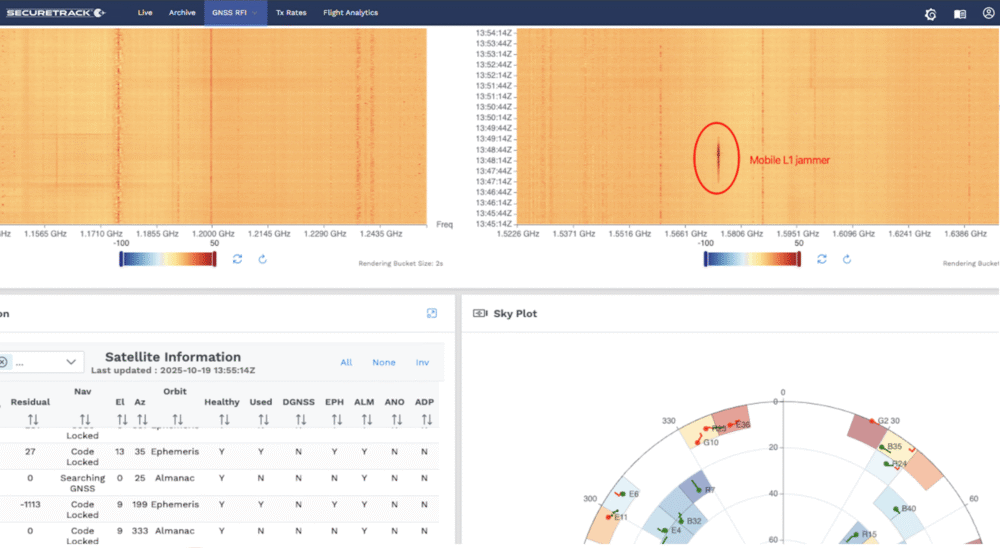
SeRo Systems, a leader in air traffic surveillance security and monitoring solutions, has introduced a new ground-monitoring capability to its SecureTrack solution, enabling unified air- and ground-based detection of GNSS interference, including jamming and spoofing. This comprehensive feature delivers real-time detection, analysis and visualization of jamming and spoofing activity across all GNSS frequency bands and constellations in a single integrated solution.
Compliant with the latest EASA and ICAO monitoring recommendations, it also offers data archival and analytics capabilities for detailed reporting. The company started rolling out this feature to users in Eastern Europe and the Baltics in mid-October.
Designed for use by Air Navigation Service Providers (ANSPs), airport operators, spectrum regulators and other government agencies, this capability uses a dedicated and controlled deployment of SeRo’s GRX receivers to display continuous, high-resolution power spectral density data (spectrogram) covering an RF band over 318 MHz wide.
Through advanced spectrum visualization and data aggregation, users gain valuable insights into the spectral fingerprint, enabling them to identify when interference occurs, which frequencies are affected, and distinguish between unintentional interference and targeted attacks.
“With this release, our customers get the highest level of protection a single system can provide,” said Matthias Schäfer, CEO of SeRo Systems. “Until now, authorities had to rely on fragmented data from different systems to monitor air and ground operations. SecureTrack now provides a unified view of live and historical GNSS interference activity in an easy-to-use interface for faster incident detection and improved system integrity. This offers an intuitive and efficient way to visualize complex RF spectrum and signal data collected by our sensors in areas that are critical to GNSS operations. It’s the perfect solution for ANSPs, airport operators, and spectrum regulators who need comprehensive situational awareness in a single integrated tool.”
With the system’s new continuous ground monitoring functions, users can view live spectrum activity or perform historical analysis over customizable time ranges. Data is displayed on intuitive waterfall and line charts that show signal amplitude over time, with color-coded intensity scales that make jamming and spoofing events immediately visible.
Its upcoming automatic alerting feature will provide real-time warnings of potential jamming or spoofing incidents by detecting unexpected positioning, navigation and timing (PNT) signals as well as anomalous spectrum activity.
The integrated Sky Plot offers additional insight into satellite positioning and antenna performance, helping users optimize installation geometry and, in the event of spoofing, understand which satellites and constellations are affected.
The Estonian news portal Delfi reports that a covert Russian military installation in the Królewiec region, just east of Poland’s border, is believed to be responsible for GPS interference affecting the Baltic states and the Gulf of Finland.
According to confidential sources, the facility’s primary mission is to monitor satellites and NATO communications, with the goal of undermining allied intelligence operations. Documents obtained by Delfi indicate that the base, located in Pioniersk, is part of Russia’s “Tobol” electronic warfare network.
The Tobol system is described as a network of surveillance, defense and command sites designed both to shield Russian satellite communications and navigation systems from NATO attacks and to disrupt NATO intelligence. The Królewiec facility, which focuses on satellite monitoring, was officially established in 2009 by the Russian Ministry of Defence. Similar installations are located across Russia, including near Moscow, Penza, Cheboksary and in Ulan-Ude, Siberia.
The Finnish newspaper Ilta-Sanomat, reports that Russia has been developing navigation jamming technology since the 1980s, initially as a counter to GPS-guided weapons. Those capabilities have since expanded in response to Western military equipment supplied to Ukraine.
Since the start of Russia’s full-scale invasion of Ukraine in 2022, incidents of GPS interference have increased in countries bordering Russia. Aviation and maritime navigation have been particularly affected, with pilots and ship crews reporting inaccurate or lost positioning data.
Radio waves emanating from secretive facilities run by Russia’s military are the culprit behind GNSS jamming in the Baltic Sea, according to Defense News.
The news outlet reports that Polish researchers collected jamming and spoofing information on incidents covering the Gdansk airport, shipping lanes, and the airspaces of Estonia and Finland. The interference has been recorded almost daily since Russia’s full-scale invasion of Ukraine in February 2022, resulting in flight cancellations, airport closures and commercial ships steering off track.
In March, eight European countries, including the Baltic states, Finland, Poland, France, the Netherlands and Ukraine, lodged a complaint with the UN about the practice. Several UN agencies have also taken up the issue, including the International Maritime Organization, the civil aviation authority ICAO and the International Telecommunications Union.
Russia, itself a Baltic Sea country, has not responded to the charges of interference. Likely origin spots include Kaliningrad, which is between Poland and Lithuania, and the St. Petersburg area. Both regions are known to have a heavy Russian military presence, including divisions specialized in electronic warfare.
Russia’s war with Ukraine continues to affect GNSS signal availability in the Baltic Sea, reports LRT News. Aircraft and ships near the Lithuanian seaport of Klaipėda are losing signals becausse of Russia’s efforts to shield its Kaliningrad exclave from potential airstrikes, said Saulius Skvernelis, speaker of the Lithuanian parliament.
“The Russians are protecting the Kaliningrad region from potential air attacks,” Skvernelis told LRT TV. “This is not specifically intended to disrupt or harm our aircraft flying to Lithuania. It’s just that the protection zone extends beyond the Kaliningrad region’s borders, and the threat, the interference, is affecting our territory as well.”
Skvernelis warned that this problem will persist across the region as long as the Kremlin continues its war in Ukraine.
Thirteen European Union member states have called on the European Commission to respond to interference with GNSS in EU countries. In a joint letter, the countries stressed that GNSS interference cases are not random incidents but systematic and deliberate action by the Russian and Belarusian regimes aimed at destabilizing regional infrastructure, especially in the transport sector, reports LRT.
“We can appeal to all EU countries and any institution, but it won’t help as long as Russia uses this kind of electronic protection for its military sites to defend itself against Ukrainian strikes,” Skvernelis said. “We must force Russia to end the war and then this problem will simply go away.”
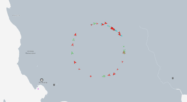
Russian jamming of GPS signals is suspected to be the cause behind a new “Bermuda Triangle” of navigation confusion in the eastern Baltic Sea.
In the Gulf of Finland, ships are disappearing from radar and Russian fighter jets are traveling through NATO airspace, according to Danwatch, a Danish news outlet.
Ship monitoring service MarineTraffic shows the position of ships in completely different places than their actual positions, currently on land east of coastal city Primorsk, Russia.
Experts say that not only is GPS being disrupted, but hackers are also manipulating navigation data. They blame Russia for its hybrid activities and attacks, which it carries out both from its mainland territory and from the Kaliningrad enclave, located between Poland and Lithuania.
Screenshot of MarineTraffic taken June 4, 2025, shows ships traveling in a circle on land, well east of the Baltic Sea.
Romania also has issues with Russian jamming and spoofing activities. The website Defense Romania quotes Gen. Gheorghiță Vlad, chief of the Romanian Defense Staff, who said jamming and spoofing has occurred on the Black Sea weekly since the start of Russia’s war with Ukraine. Also, Romanian defense forces have discovered 122 floating mines in the sea.