To assist drivers losing their navigation assistance in tunnels such as those in New York, Baltimore, Boston and Pittsburgh, app maker Waze has begun pilot projects installing electronic beacons. Each about the size of an E-ZPass, the beacons are installed within tunnels to guide the way via Bluetooth. No GPS signal in the tunnel means no directions upon emerging into daylight. That can cause a missed exit — or worse.
Waze spokesperson Meghan Kelleher said one beacon is placed every 40 feet or so to provide seamless smartphone navigation throughout the tube and to allow people to note traffic troubles on the crowdsourcing app. But even non-Waze users can benefit.
“It’s actually an open technology,” Kelleher says. “We’re making it available free of charge to other navigation services.”
Each mile of beacons costs about $300 per year. The hardware is made by Bluvision with batteries are designed to last about six years.
Waze has just switched them on in the Fort Pitt and Liberty tunnels in Pittsburgh with an eye on getting governments and other agencies to foot the bill in the rest of the world’s tunnels.
Photo: the justified sinner via Foter.com / CC BY-NC-SA
Emergency preparedness company McMurdo has launched a new family of Emergency Position Indicating Radio Beacons (EPIRBs) that will accelerate the search-and-rescue process by combining multiple frequencies — including GNSS — into a single EPIRB product.
The McMurdo SmartFind and Kannad SafePro EPIRBs are distress beacons that can support each of the four frequencies used in the search-and-rescue process: GNSS for location positioning, 406 MHz and 121.5 MHz for beacon transmission, and Automatic Identification System (AIS) for localized connectivity.
The multiple-frequency capability will ensure faster detection, superior positioning accuracy, greater signal reliability and, ultimately, accelerated rescue of people or vessels in distress, the company said.
Expanded satellite connectivity. McMurdo SmartFind and Kannad SafePro EPIRBs have a multiple GNSS satellite constellation receiver supporting Galileo (once the constellation is fully operational), GPS and GLONASS — from a single beacon. Advanced GNSS data processing results in faster detection of positioning coordinates and enhances the accuracy of the emergency location.
Most of today’s EPIRBs use 406 MHz and 121.5 MHz frequencies via satellite communication to provide location and positioning data to global search and rescue personnel who may be several hundred miles away.
The additional AIS channels on the new McMurdo SmartFind G8 AIS and Kannad SafePro AIS EPIRBs will send position signal information to standard AIS electronic equipment on nearby vessels for complementary, local tracking and rescue capabilities. This global and local rescue capability will result in quicker signal detection and faster response times.
The McMurdo SmartFind and Kannad SafePro EPIRBs are part of McMurdo’s comprehensive search and rescue ecosystem. As the world’s provider of an end-to-end search and rescue ecosystem — including distress beacons, satellite ground stations, mission control and rescue coordination systems, and rescue response products — McMurdo builds, integrates and tests products as part of a live search and rescue system. This ensures greater cohesion between distress signal transmission and reception so that beacon owners can feel confident that their signals will get to search and rescue authorities quickly.
MEOSAR compatibility. The McMurdo SmartFind and Kannad SafePro EPIRBs are designed to be fully compatible with MEOSAR, the next generation of the Cospas-Sarsat international search-and-rescue satellite system that has helped to save over 40,000 lives since 1982. MEOSAR will increase the speed and accuracy of beacon signal detection and location with new MEOSAR ground network infrastructure and additional MEOSAR satellites.
When fully deployed, a MEOSAR-compatible beacon can be located with an accuracy of location within 100 meters (328 feet), 95 percent of the time — and within five minutes of distress signal activation, all without reliance on GNSS.
McMurdo manufactures approximately 50 percent of the world’s MEOSAR infrastructure and is also leading the design of additional MEOSAR-capable beacons under the European Union’s Horizon 2020 Research and Innovation Program’s HELIOS project.
“McMurdo’s new EPIRB announcement is a major step towards achieving a unified search-and-rescue vision,” said Bruce Reid, CEO of the International Maritime Rescue Federation. “The convergence of products and systems whether AIS and 406 MHz or maritime domain awareness and search and rescue, respectively, will require a comprehensive understanding of the entire search and rescue ecosystem. I look forward to seeing more McMurdo solutions and innovations that will shape the search and rescue industry for years to come.”
The McMurdo SmartFind and Kannad SafePro distress beacons support beacon transmission, GNSS for location positioning, and AIS for localized connectivity.
Harxon has released a utility beacon antenna — HX-CS7615A — to professionally solve marine satellite positioning challenges.
The HX-CS7615A supports GPS L1/L2, GLONASS L1/L2 BDS B1/B2/B3 and beacon frequencies (282.6 to 326 KHz), which greatly overcomes the defects of long-distance transmission limits, the company said. In addition, combining wide frequencies in one antenna makes the new device more cost effective.
Inside, a multipath rejection board significantly eliminates measurement error, Harxon said. The phase center of the antenna remains constant as the azimuth and elevation angle of the satellites change.
The HX-CS7615A Harxon marine antenna.
The HX-CS7615A is designed with high gain and wide beam width. It is test approved — even in some severe blocking situations, its reception remains stable.
A specialized antenna made for rugged environments, the HX-CS7615A beacon antenna is sealed against water and dust, is salt and fog resistant, and operates in extreme weather conditions.
Wirepas and u-blox have partnered on an advanced decentralized radio communications solution, the NINA-B1 module, for industrial Internet of Things (IoT) applications. The goal of the partnership is to make large scale, decentralized industrial IoT networks easy to deploy for the companies’ customers.
The small NINA-B1, which the companies say is comparable to advanced mesh technology, is a stand-alone Bluetooth low energy module with the latest power performance. It can be used for applications such as healthcare, connected buildings, manufacturing and telematics. The module has been certified for a range of countries world-wide, according to the companies.
“The NINA-B1, in combination with the Wirepas Connectivity software, enables short time to market for easy-to-install, large scale, decentralized industrial IoT applications in segments such as lighting, sensor, asset tracking and beacons,” says Hakan Svegerud, head of product strategy, short range radio, at u-blox.
“We believe that technology should never be the starting point; instead, we should concentrate on business and application needs,” says Wirepas CEO Teppo Hemiä. “As needs evolve over time, so should the technology. Wirepas and u-blox share this core value and that is what makes us stronger together.”
Extraordinary though satellite navigation may be, GPS and other satellite-based constellations are limited when there is not a line-of-sight or near-line-of-sight path to at least three (and preferably more) satellites. These systems also do not provide sufficiently accurate and reliable altitude information for most applications, especially indoors. Finally, power consumption is an issue for user equipment.
It has been easy to overlook these limitations as the enormous benefits of GNSS have become pervasive, but the increasing demand especially for indoor geolocation now requires a robust solution designed for the indoors and urban canyons. Support for Terrestrial Beacon System (TBS) location technologies was incorporated in Release 13 of the Third Generation Partnership Project (3GPP). These technologies are complementary to GNSS, and provide a comprehensive solution to these limitations.
One of the TBS in development is the Metropolitan Beacon System (MBS) implementation by NextNav, which is the subject of this article. NextNav is deploying the first MBS network in the United States, using spectrum in the 920–928 MHz band, on licenses that cover about 98 percent of the U.S. urban population.
3GPP is the standards development organization for cellular wireless specifications, and is in part responsible for the popularization of GPS through its standardization in the 3GPP Release ’98 specifications. Release ’98 enabled wireless operators to adopt GPS and bring their economies of scale to GPS positioning.
Release 13 support has similar potential for MBS, enabling support for MBS in any Release 13-compliant LTE network throughout the world. As with the original standardization of GPS in 1999, incorporation of MBS in this release was driven primarily by the need for wireless carriers to provide accurate indoor geolocation for E911 calls.
MBS complements GPS by providing precise geolocation and timing indoors, in urban canyons, and other locations where GPS signals are either unreliable or unavailable. MBS receivers work seamlessly with GPS so they are as transparent to the user as satellite-based systems. MBS can provide floor-level altitude and navigation in indoor environments.
Typical mall experience: green dots show NextNav computed positions relative to ground truth (red line).
How it works
MBS transmitters are similar in many respects to GPS satellites that are deployed terrestrially. Unlike communications systems, MBS is deployed with a view toward minimizing dilution of precision (DOP) so that the signals available at any indoor or outdoor location will meet the unique requirements for accurate geolocation. DOP is an indicator of the three-dimensional positioning accuracy of a radio positioning system’s signals as they are “viewed” by a receiver.
GPS signals are typically 30 dB below the thermal noise floor at the Earth’s surface, and thus GPS receivers require a significant amount of processing resources for acquisition and tracking. Acquisition time can be quite long, up to 12 minutes in the absence of almanac and ephemeris information. Modern commercial implementations with some assistance information is typically closer to 30 seconds.
Mall store accuracy tests depicting indoor tracking performance in suburban mall environment. Dots show MBS-drive information, with no additional data from inertial or other sensors.
Throughout this time the receiver is running at full bore, drawing a considerable amount of current, the bane of any battery-operated device. MBS mitigates these problems because the 30-Watt radiated power of each terrestrially located transmitter combined with a satellite-like link budget provides greater received signal-to-noise ratio.
The result is an acquisition time without assistance information of 6 seconds or less, and 1 second if assistance information is available. The ease of acquiring and tracking MBS signals has significant implications for power draw and power management strategies.
Metropolitan beacon rooftop transmitter.
Although deploying a wireless network of any kind is a complex endeavor, MBS benefits from the ability to cover an area using fewer beacons, thanks to its relatively high RF output power (but much lower than cellular signals) and robust processing gain.
The transmitters typically share space with existing cellular systems on towers and building rooftops and are compact. The antenna is typically a 5-foot, vertically mounted, omnidirectional element.
The system provides for redundancy at both the transmitter and network levels, and the signals are encrypted for security. Like GPS, location can be calculated by the user’s device.
Baseband Change. MBS was designed to be like another constellation on a multi-constellation GNSS processor, and primarily constitutes a firmware change to modern baseband designs. The primary receiver changes are related to the analog components (accommodation for a different frequency band and higher dynamic range).
Enabling MBS in a smartphone requires a few inexpensive passive components and slight modifications to the antenna. From an RF perspective, NextNav’s MBS operating frequency is sandwiched between bands currently used by wireless carriers, so few if any changes to a standard FR lineup is required.
Tackling cellular first
Most of the billions of mobile phones shipped every year incorporate GPS receivers. Because GPS does not work reliably inside a building, however, mobile devices must fall back to ad hoc positioning methods based on communications infrastructure. This has become increasingly important because mobile wireless devices are used predominately indoors at least 70 percent of the time, according to a study by J. D. Power and Associates. This makes reliable indoor geolocation essential for consumer, commercial and public safety interests.
The MBS architecture was designed to integrate into the GPS ecosystem and integrate organically within modern mobile devices, without the need for separate chips or elaborate reengineering.
The additional benefit of determining altitude along with horizontal position is also significant. Indoors, context is determined as much by the vertical as the horizontal — for example, in a multi-level shopping mall. In emergency-response scenarios, critical seconds or minutes can be shaved off of response time if the floor in which an emergency is occurring can be reliably determined.
Control-plane architecture (LTE) for NextNav E2E.
Power and the IoT. The Internet of Things offers substantial productivity gains. Nevertheless, there have been limitations to the rapid adoption of certain IoT technologies. Among these is a fierce battle among competing low-power wireless communication standards. Lower power operations are the key for many IoT implementations, and location is one area where power savings, especially for wide-area location, are critical.
While MBS is generally designed to complement GPS, in IoT operations it has the potential to replace GPS in some cases due to power savings available from the system. Due to its terrestrial nature, the MBS signal is much stronger than GPS, enabling significant power savings. Many applications are expected to be enabled by such a system, whether for very long-life applications with intermittent position reporting to always-on location (that is, persistent tracking). Location capabilities on wearable devices are also very desirable, but because of power constraints, provision of location through GPS has been difficult to realize.
The general benefits of a terrestrial constellation also apply to non-power-limited applications, especially in urban environments and those where altitude is a critical feature. Driverless cars and unmanned aerial systems, for example, rely on GPS but also need precise 3D location accuracy.
Vertical accuracy performance of mass-market devices.Another example of vertical accuracy performance of mass-market devices.
Applications in 5G small cells
The fifth generation of carrier wireless, 5G represents another potentially significant application of MBS technology. Achieving 5G’s ambitious goals — standards are expected to be complete by 2019 — will require a massive infrastructure increase, including small base stations, or femtocells, that must be time-synchronized to avoid interfering with each other. A large percentage of these are expected to be deployed indoors.
This means wireless carriers, neutral hosts and other infrastructure operators will need to bring timing synchronization signals inside. This typically requires GPS receivers to be placed on rooftops with the received signal fed to multiple indoor locations by running cables throughout the facility.
To an operator in a metropolitan area with hundreds or even thousands of indoor small cells, this represents a large investment in capital equipment and limits customer-based installation. MBS can provide a timing signal that can be received indoors through the use of a modified multi-constellation GNSS chipset, a low-cost and convenient alternative.
Beyond cellular
The enablement of MBS in 3GPP has drawn attention from those seeking geolocation for a range of other devices. EF Johnson Technologies, a provider of radios and other equipment for public safety applications, demonstrated the integration of MBS in its Viking P25 (Project 25) radios. As P25 radios are the standard for mission-critical voice in the public safety community, the ability to carry MBS information could be a key feature for first responders.
Elder care, monitoring family members, security guards, assets, and hospitality employees: any application that experiences service limitations due to indoor lack of availability is a candidate to augment service with MBS service, or, if power is a very serious issue, simply rely on MBS alone.
Summary
MBS complements GNSS systems by providing indoor coverage, altitude positioning and lower power consumption. By leveraging the existing GNSS ecosystem, low-cost, high-volume receivers can be adopted and service become seamless among satellite and terrestrial systems.
Other indoor PNT technologies
The 2013 CSRIC Trials administered by the FCC also tested technologies from Qualcomm, Polaris Wireless and True Position.
GPS World plans to publish articles about these and other alternative technologies in upcoming issues.
Let’s look through the other end of the telescope this month. The satellites are nattering along, lining up in orderly fashion at the rocket pad, extending their solar arms smoothly in space once they arrive on orbit. The constellations accrue and new signals inch closer to maturity.
The only blips on the horizon come from Ligado’s terrestrial impulse and a looming gap in GPS ground control. Just possibly, the latter might coincide with activation of the full European constellation and Galileo could come to the rescue of suitably equipped users who hunger for greater accuracy. This has been Galileo’s raison d’etre for two decades now, and it may actually be on the cusp of coming true.
At any rate, back to the telescope’s other end. What might that be? Facebook.
“When you think back to the beginning of online advertising, this is what advertisers have been waiting for.” That is Facebook’s director of monetization product marketing — an actual job title, and a powerful one in time to come.
All this — what advertisers have been waiting for — is made possible by GPS. Soon, by all GNSS. And by your smartphone.
From a GNSS Design & Test point of view, this means we are about to see some real money come available for constellations. Fast-multiplying applications of position, navigation and timing data have always shaped GNSS evolution, to some degree. Making this latest development different by a degree of magnitude is its potential to alter the way GNSS policy is shaped and the way GNSS funding is provided.
Facebook will soon roll out a new Store Visits metric for business clients: location data and purchases correlated to Facebook ad performance. Partnerships with point-of-sale systems like Square and Marketo will “prove” (let’s use that word loosely for now) who bought what after seeing Facebook ads.
The way the company tells it, “While people use mobile in 45 percent of all shopping journeys, more than 90% of sales still happen in brick-and-mortar businesses.”
Even if you don’t buy something, Facebook will know that you — assuming, and this is a big jump, that you are a Facebook user — visited a store by aligning GPS, beacon, Wi-Fi and other radio-frequency signals and cell-tower locations with brick-and-mortar coordinates. You may not be a Facebook user, but I’ll bet one of your loved ones is.
With the new feature, instead of having to (gasp!) leave Facebook to visit an unfamiliar website for a store locator, users can view the address, hours, phone number and estimated travel time without exiting the social network.
I know people who rarely or never leave Facebook. Do you? This is a plus for them.
Facebook, one of the new corporate mega-giants, duels with Google, Apple and Microsoft over various pieces of digital turf. One of the most hotly contested treasures — the Holy Grail, in marketing execs’ terms — is the capture and use of user data. It is getting more than a little bit creepy.
To date, the even-bigger giant that is advertising has used metrics such as ad views and clicks to measure effectiveness: how much an ad actually inspires purchase or response to other calls to action. I know this because I use these metrics, or someone in my organization does. Such metrics are now deemed “flimsy” by the standards of aligning GPS, beacon, Wi-Fi data and so on as outlined above.
Facebook is not alone in exploring the fertile ground. Google recently launched ads that show maps of nearby locations, and the others surely do not lag far behind. For the moment, these massive integrators aggregate and anonymize the data to protect privacy, but that’s not to guarantee they would always do so. Currently, there’s no specific opt-out other than turning off location services for the app on the user’s device, which people might be reluctant to do if it degrades other app functionality.
Let’s shield our eyes from the dark side for the moment, and consider what this means for GNSS.
We, you and I, those of us in the PNT industry, have known for some time how integral to critical infrastructure GPS is and GNSS soon will be. But the vast public does not. And lawmakers, bless their little hearts, largely do not either. That will change when the desperate craving of large companies to reach billions of buyers enters the PNT arena.
We can envision mega-marketing bolstered by alliance with the transportation industry, both ground and air, as driverless vehicles and drones become more commonplace. With powerful lobbying interests behind it, GPS might finally get some respect, and other systems around the world with it. Modernization might proceed more smoothly and quickly, without funding hiccups and capability gaps. That’s the bright side of all this.
It reminds me of nothing so much as an old rock’n’roll song. In “Top of the Pops,” the Kinks sang:
Now my agent called me on the telephone He said, son your record’s just got to number 1 And you know what this means?
A huge network of iBeacon (Apple)and Eddystone (Google) devices has emerged in China, consisting of 110,000 units run and managed by Sensoro.
The network spans 25 movie theatres, 16 airports, 39 high-end retail stores, 40 major tourist destinations, 200 universities, 260 high-speed trains, 1,500 Pizza Huts and 2,100 Chow Tai Fook (CTF) jewelry stores, among other locations.
Sensoro was founded in July 2013 through the Microsoft Ventures Accelerator program for startups. Its goal is to construct a data network that integrates intelligent sensors (in this case, Bluetooth) and the mobile Internet.
During the 2015 Chinese New Year in February, traffic at beacon-outfitted locations reached the hundreds of millions, according to a Sensoro blog. CTF’s use of the iBeacons generated 11 million dollars in revenue with a coupon conversion rate as high as 63 percent, far surpassing expectations, according to CTF’s 2015 earnings report. CTF has since deployed beacons in all 2,100 of its mainland China retail stores.
Data gathered by Sensoro will allow retailers to target customers with increasing accuracy the longer the network is in use.
Navigation using High-Frequency Ground Beacons and Ionosphere Model Corrections, by Yoav Baumgarten and Mark L. Psiaki, Cornell University.
A new navigation concept relies on passive one-way ranging using pseudorange measurements of high-frequency (HF) beacon signals reflected off the ionosphere.
This is being developed as a possible alternative to GNSS positioning and timing services, with benefits in costs and system redundancy. The HF signals are transmitted from ground-based beacons, traveling from known locations to the unknown user equipment (UE) location along ray paths that reflect off the Earth and the ionosphere. If a set of beacon signals reaches the UE receiver with sufficient geometric diversity, then the three-dimensional position and the clock offset of the receiver can be determined.
Presented at ION GNSS+ 2015.
Inertial Sensors
Dynamic Stochastic Modeling of Inertial Sensors for INS/GNSS Navigation, by M. Wis, Deimos Space, Spain; Ismael Colomina, GeoNumerics, Spain.
Researchers performed a series of experiments with a low-cost inertial device rigidly attached to a navigation-grade reference IMU and found a direct relationship between the low-cost IMU errors and the high-order dynamics. Preliminary results suggest an approach of low-cost sensor modeling that might help reduce some of the errors inherent to the dynamics applied to the sensors.
Presented at ION GNSS+ 2015.
GNSS-INS Integration
Quasi-Tightly-Coupled GNSS-INS Integration with a GNSS Kalman Filter, by Bruno Scherzinger, Applanix Corporation, Canada.
This method, intended for integration of an existing GNSS navigation engine into a GNSS-INS closed-loop configuration with little/no modification of the navigation engine, uses a range measurement model matrix typically used to compute dilutions of precision (DOP) to identify the observable subspace in the time-space frame generated by the available satellites and project the loosely coupled INS-GNSS Kalman filter position measurement into this subspace.
Aruba, a Hewlett Packard Enterprise company, has introduced a cloud-based beacon management solution designed for multivendor Wi-Fi networks and beacon analytics. Aruba also expanded its app developer partner program for the Meridian Mobile App Platform to accelerate innovation of location-based mobile apps.
Since its launch in November 2014, Aruba Mobile Engagement, powered by Aruba Beacons and the Meridian Mobile App platform, has improved customer satisfaction in such diverse organizations as Levi’s Stadium and Orlando International Airport, Aruba said in the news release. Aruba Mobile Engagement directly interacts with customers through their mobile devices based on the customers’ in-venue location and personalized preferences.
The new Aruba Sensor is designed to dramatically reduce IT overhead and make it easy to manage all beacons from a single location. Aruba estimates approximately 48 hours of time savings in a 1,000-beacon deployment during a single maintenance window.
The new enterprise-grade Internet of Things Aruba Sensor combines a small, Wi-Fi client and Bluetooth low energy radio to remotely manage beacons across existing multi-vendor Wi-Fi networks from a central location. For IT departments, this means easier and significantly more cost-efficient management and monitoring of beacon data including battery life, power settings and software updates, Aruba said.
Orlando International Airport (MCO), which hosts nearly 38 million travelers annually, implemented Aruba’s Mobile Engagement solution in late 2014 and has since seen more than 26,000 downloads of its MCO mobile app.
“Since so many travelers now rely on mobile apps, the accuracy and reliability of the information we’re delivering is paramount,” said John Newsome, director of information technology for the Greater Orlando Airport Authority. ” Today, to ensure this accuracy, our IT staff must monitor the beacons manually which is burdensome for such an extensive deployment. Using the new Aruba Sensors, however, we’ll be able to manage our beacons remotely, saving valuable time and IT resources.”
Reasons Cited Include Privacy, Lack of Retail Support
Kevin Dennehy
Google Here, a proposed beacon-based location service operating within Google Maps, was reportedly cancelled due to a concern by Alphabet CEO Larry Page’s that it would be too invasive by the users of his mapping service. When the location industry has such a dominant player pull out of a nascent, and potentially lucrative, proximity service, does it mean that consumers will now have to wait for a full-scale rollout? Google will remain a major player with its Google Maps app, but where does it go from there?
Citing privacy issues and lack of retail partners for support, Google scraped its Google Here location service that would have used the company’s Maps technology to send notifications to users when they entered a specific location.
In a recent Fortune article, Alphabet CEO Larry Page said the company killed the project because it was too invasive to consumers, and the company was uncertain whether retail partners could have helped to roll out the service. Besides being in conflict with an existing location Here name (such as the former Nokia, and now German consortium, mapping service), the service included partnerships with retailers — and would have been available to more than 350 million Android users earlier this year.
Google makes money off of advertising through its Maps app, but the Fortune article said that the proposed Here location service would have made it even more valuable to advertisers.
So what does the location industry make of one of the largest players not rolling out a location service? To at least one analyst, it’s a “so what” report considering Google in July rolled out a new agnostic beacon service called Eddystone. “Somewhat curiously, the company appears to be moving forward with location-based advertising under the guise of the Eddystone project, so beacons and their use in location-based advertising seem still of interest — just not beacons combined with messaging that might make Google Maps an uncontrollable nag about shopping opportunities,” said Mike Dobson, Telemapics president.
Eddystone, a new format for Bluetooth Low Energy beacons, works with Google’s Android operating system along with Apple’s iOS and other platforms that connect through BLE.
Overall, Dobson believes that Google is approaching middle-age in terms of corporate development. “It is both developing a conscience about how its services really operate, as well as imposing economic constraints limiting how much the company is willing to spend to determine whether a potential market might be a big hit,” he said. “More specifically, it is my opinion that Google is slowly reining in the spending on new innovations for Google Maps, as well as the expenses associated with supporting the lakes in the data reservoir associated with their mapping product. Google may have finally realized that maintaining spatial data is expensive and a cost that is never going to decrease.”
Dobson also said that the Google Here program was going to be an expensive proposition. “My understanding of the Google Here program was that Google would provide the beacons and infrastructure and control delivery of the service through Google Maps. That’s a lot of beacons and associated support — in other words, more money,” he said. “Conversely, Eddystone appears to offer a standardized, industry-supported approach that is beneficial for Google and companies interested in testing the concept.”
Dobson said the name “Here” could have caused problems for Google. “Two other issues crossed my mind when I heard the news of the cancellation. First, who at Google forgot trademark law and thought they could combine the name of the well-known mapping company Here with Google?” he said. “Second, if I owned an application as successful as Google Maps is on mobile phones, I sure would not want to push my users to consider switching to a less-invasive mapping app. You know, that Larry Page guy sure seems to know his Alphabet.”
Big Competitors Getting into Beacons, with Huge Market Expected
Recent Allied Business Intelligence reports indicate that BLE beacon shipments will exceed 400 million units by 2020. While optimistic, and only five years away, ABI said that pure beacon shipment revenues will break $1 billion this year.
Google’s July entry into the location-beacon space is significant, if not surprising, to heat up the location market. However, competition is fierce as Apple, Facebook and Twitter now have dedicated BLE resources.
The location-beacon market is heating up as Gimbal, the Qualcomm spin-off company, installed approximately 1,300 BLE beacons in areas at South by Southwest. Gimbal said it was making its technology available to enable any BLE device to act as a dedicated location beacon.
Google plans to improve its own products and services through the Eddystone beacon technology, according to a company blog. Earlier this year, the company launched beacon-based transit notifications in Portland that enable users to get faster access to schedules for specific locations.
With rise in commercial location-based beacon technology comes a cross-over movement in public safety markets. TeleCommunication Systems, which bought Loctronix in July, is developing the indoor public safety and emergency market, along with Longmont, Colo.-based Intrado.
As detailed in last month’s Wireless LBS Insider column, beacons and Wi-Fi seem to be the lead technologies in use for emergency indoor location. Intrado installed 65 Apple iBeacons at the Washington Convention Center to showcase its developing indoor positioning technology at the APCO trade show.
It’s not all about beacons in this proximity/contextual location market. The analytical data derived from the beacon information will grow into a huge market. As we reported this summer, a new location analytics product is hitting the market in a more and more crowded indoor-positioning field.
Such companies as Cloud4Wi, with its Fogsense product, is tailored to retail outlets, coffee shops, restaurant chains and shopping malls with presence analytics and location-based services.
The device, which contains Broadcom’s WICED chip, features BLE technology in the new version in (the fourth quarter), said Elena Briola, Cloud4Wi’s chief marketing officer. The new BLE version will enable Apple iBeacon and location-aware mobile applications, the company said.
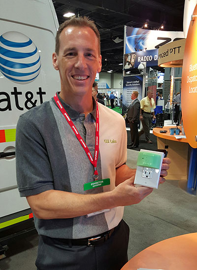
TCS’ Matt Vincent poses with public safety gear that includes Taoglas Storm Antenna at APCO.
It is refreshing to see nascent technology such as indoor location being used to enable accurate emergency services response. That’s what’s going on right now as beacons, Wi-Fi and other technology that works inside, where GPS doesn’t work, is being tested nationwide by companies hoping for government adoption. With new FCC regulations that are finally trying to keep up with commercial location products, it may be a reality soon. What really drove location into wireless handsets was the 1990s FCC regulations — will they now drive indoor positioning?
GSI Labs’ John Martin holds indoor beacon at APCO.
WASHINGTON — The same technology that allows consumers to find products indoors will allow emergency personnel to locate people in trouble in the coming years, said officials at the Association of Public-Safety Communications Officials (APCO) annual meeting here, held Aug. 16-19.
Companies are using existing commercial technologies, also used by retailers to determine customer preferences, to provide indoor location in combination with the National Emergency Address Database. This provides public-safety answering points, or PSAPs, accurate addresses and positions to dispatch emergency services to allow first responders to find people on specific floors and in rooms, not huge areas.
Beacons and Wi-Fi seem to be the lead technologies in use for emergency indoor location. Longmont, Colo.-based Intrado installed 65 Apple iBeacons at the Washington Convention Center to showcase its developing indoor positioning technology.
“Old 9-1-1 technology was just a dot on the map. Now people are saying, ‘how can Starbucks can find me, but 9-1-1 can’t?’” said John Snapp, Intrado senior technical officer.
Another company, TeleCommunication Systems, is getting into the indoor public safety market with its LocatE9-1-1 product that leverages the company’s indoor location engine, or ILE. The ILE connects to multiple databases that can be used during a 9-1-1 call to determine what location information is available for the wireless device.
“Deep inside buildings, location technology often fails us. Sometimes emergency workers have to rely on verbal information [from people at the scene],” said Tim Lorello, TCS senior vice president and chief marketing officer. “We are a location aggregator. However, we do know location won’t be deployed everywhere, but there are multiple technologies tied to Wi-Fi hotspots, barometric pressure and Bluetooth.”
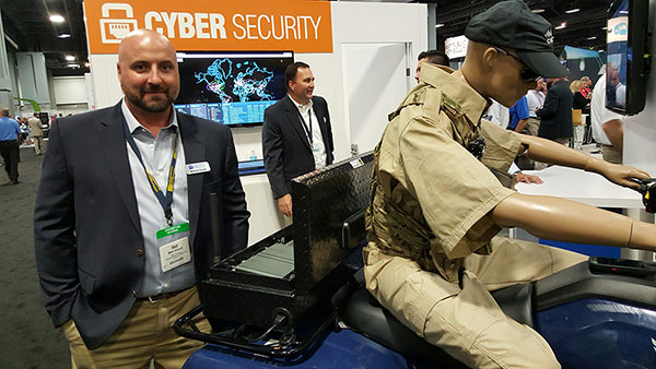
In addition to government agencies, wireless carriers are taking notice of the indoor positioning capabilities for public safety. At APCO, GSI Labs, a 20-year-old business, was in the AT&T booth displaying its codeBlue-911 beacon system. “We think that for bigger venues such as warehouses and stores, this is a great public safety tool. The [Bluetooth Low Energy] beacons have about 20-to-50-foot accuracy, depending on the battery,” said GSI Labs’ John Martin. “A security company is looking at using the beacons to monitor employees during the night.”
OnStar booth features wrecked car to portray emergency messaging capabilities at APCO.
FCC Still at Forefront of Location Accuracy Requirements
In an address at the conference, FCC Chairman Tom Wheeler said that the agency has taken steps to increase the reliability of the nation’s 9-1-1 system. “Uber can pinpoint [a potential customer]. We won’t tolerate 9-1-1 failures,” said Wheeler, who also called for a national maps database.
Some people newer to the location industry don’t remember it was the enhanced 9-1-1 FCC rules that drove the installation of GPS into cell phones in the mid-1990s. In several presentations at APCO, it was noted that more than 80 percent of all emergency calls are made with a wireless device, not landline.
The FCC announced new rules this year that require wireless operators to provide dispatchable location within 50 meters with these new deadlines and conditions: 40 percent of all wireless 9-1-1 calls within 2 years; 50 percent within 3 years; 70 percent within 5 years; and 80 percent within 6 years.
If anyone doesn’t think the FCC is the 800-pound regulatory gorilla for location, then they have missed the LightSquared GPS signal interference saga. According to published reports, LightSquared has hired Reed Hundt, former FCC chairman, as an attorney representing the company.
LightSquared, which is trying to emerge from bankruptcy, has been seeking FCC approval to transfer its spectrum licenses to its new entity. The company is trying to see if the GPS interference issues can be resolved.
In other APCO news, Time Machines rolled out its TM 2000A timing device that costs $499.95. The big deal about the timing device is the price — which has many of the same features that competitors offer for more than $5,000, said Doug Ehlers, Mindshare by CSS president, a sister company of Time Machines, who also said the company is expanding its distribution in Europe.
Gimbal Partners with Do It Outdoors Media
While emergency networks are getting big, the commercial networks are continuing to make inroads with advertising agencies and partners. Location and proximity-based marketing company Gimbal recently partnered with Do It Outdoors Media in a deal that will use Gimbal’s beacon technology.
Gimbal said that Do It Outdoors Media, which is the largest national mobile billboard and field marketing company, will create a smartphone campaign that provides proximity-based consumer offers to opt-in users.
Beacons will be placed in Do It Outdoors Media’s mobile billboard units, which are owned and operated by the company. In addition, there will be product placement on Segways, jet packs, brand ambassador teams and other marketing sites.
Gimbal says that when a consumer enters into a beacon zone, which is effective from 50 meters away, content will be delivered through a push notification within an advertiser’s or a third-party mobile app.
In other location news:
While a small trade show for a focused group of government communication professionals, APCO drew 5,700 attendees, with 282 exhibitors. Conference organizers said it was the highest attended show in seven years.
An updated version of the former GPS-Wireless conference will take place Dec. 2-3 at the Crowne Plaza San Francisco Airport Hotel. The conference, Location IoT, will focus on new markets for M2M and the Internet of Things. Topics will include indoor location markets, connected vehicles and many others. Two hosted networking receptions are included. Contact me, Kevin Dennehy, at kdennehy @g psworld.com for more information.
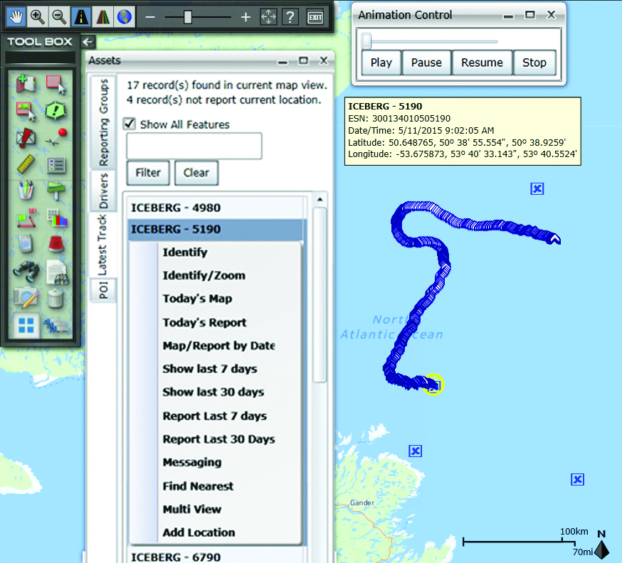
Drifting tabular icebergs viewed from the Amundsen. (Photo courtesy of Greg McCullough, University of Manitoba)
A Canadian expedition team used GeoDecisions’ GeoILS platform to help track icebergs during a voyage to better understand how icebergs drift. An intelligent location server using the Esri ArcGIS platform, GeoILS enables users to monitor and locate assets and facilitate quick and coordinated responses.
GeoDecisions, an information technology company specializing in geospatial solutions, partnered with Solara Remote Data Delivery Incorporated, Canada’s Carleton University and Esri during the project.
The FT2000IB Solara tracker. (Photo by Tom Tessier)
Led by University of Manitoba Scientist David Barber, the crew of Canadian Coast Guard icebreaker Amundsen sailed off the coast of Newfoundland and Labrador to research ice hazard mitigation, the effects of climate change, and polar region technology requirements. GeoILS location intelligence helped crew members visualize, analyze, and leverage project-pertinent data.
“During the expedition, researchers and scientists used GeoILS to assess drifting through sensor monitors attached to the icebergs,” said Brian Smith, vice president of commercial solutions with GeoDecisions. “In addition to reporting and notifications, GeoILS provided the project team with maps that were tailored by selecting desired iceberg information and the geographic area of interest based on user-defined criteria.”
GeoDecisions’ data portal was used with Iridium Solara tracking devices during the iceberg research project. Two icebergs were outfitted with FT2000IB Solara trackers, explained Derek Mueller, assistant professor and physical geography program supervisor with Carleton University.
THE GROUND control point and beacon. (Photo by Derek Mueller)
For each iceberg, two beacons were attached for redundancy and to determine the iceberg’s rotation. Holes were drilled and stakes inserted, then GeoDecisions Platform Tracks Icebergs the trackers attached to the stakes.
The trackers were also used as ground control points for photogrammetry, specifically the structure from motion ranging imaging technique.
“GeoILS and the satellite tracking beacons worked very well during this project,” Mueller said. “Thanks to our partners’ efforts, we now have a great new suite of tools for examining our data.”
“We are excited to provide tools to scientists who are gaining critical insights into the behavior of icebergs and global climate change,” said Tom Tessier, president of Solara Remote Data Delivery Incorporated.
The last tracker stopped transmitting on June 13. “The others ended earlier, likely because the iceberg rolled or broke up,” Mueller said.