China’s BeiDou navigation industry in 2025 achieved a total output value of 1.33 trillion yuan (US$195 billion), according to a report released Monday by the GNSS and Location Based Services (LBS) Association of China, or GLAC, reports CGTN.
The BeiDou industry includes remote sensing and geographic information systems (GIS), mobile communications and indoor positioning. The satellite navigation sector generated 629 billion yuan (US$92 billion) in 2025, up 9.24% year on year, according to the report.
China has established a complete BeiDou industrial chain and supply chain, covering chips, modules, antennas, terminals, system integration and application services, , according to the report. Domestic capabilities are becoming increasingly self-reliant, with the cumulative shipments of BeiDou-compatible chips and modules reaching hundreds of millions, supporting a secure and robust industry supply chain.
Domestic sales of BeiDou-enabled terminals exceeded 410 million units in 2025, with more than 2.2 billion BeiDou-capable devices in use across the country.
Internationally, BeiDou services and related products have been exported to more than 140 countries and regions.
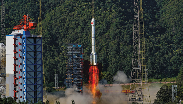
Successful launch of the 59th and 60th BDS satellites on Sept. 19, 2024. (Photo: International Cooperation Center of China Satellite Navigation Office)
Upholding the principles of “superior construction, excellent management, and substantial development,” the BeiDou Navigation Satellite System (BDS) implements multifaceted strategies to ensure uninterrupted and stable system operations and services, with its backup satellites launched into orbit as per the scheduled plan in 2024. Concurrently, research on next-generation BDS technology upgrades and related technological trials for integration with low-Earth orbit (LEO) positioning, navigation and timing (PNT) systems are vigorously promoted, further enhancing international collaboration and propelling the continuous advancement of BDS in the new era.
1. System operation and services
All figures provided by the author.
BDS currently consists of 45 operational satellites in orbit, delivering services through 15 BDS-2 and 30 BDS-3 satellites. Since May 2023, five BDS-3 backup satellites have been launched to bolster system resilience.
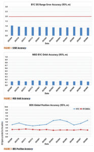
According to the monitoring data from the International GNSS Monitoring and Assessment System (iGMAS) and the International GNSS Service (IGS) in 2024, BDS achieves a service availability of 100% and exhibits a single satellite signal continuity of 99.991% per hour, with signal-in-space accuracy surpassing 0.9 meters (95%), broadcast ephemeris accuracy surpassing 0.2 m (95%), single frequency three-dimensional positioning accuracy of the B1C signal better than 6 m (95%, global average), and the B1C/B2a dual-frequency three-dimensional positioning accuracy superior to 3 m (95%). The timing accuracy is noted to be better than 10 ns (95%). The performance of the BDS PNT service has consistently met all performance requirements.
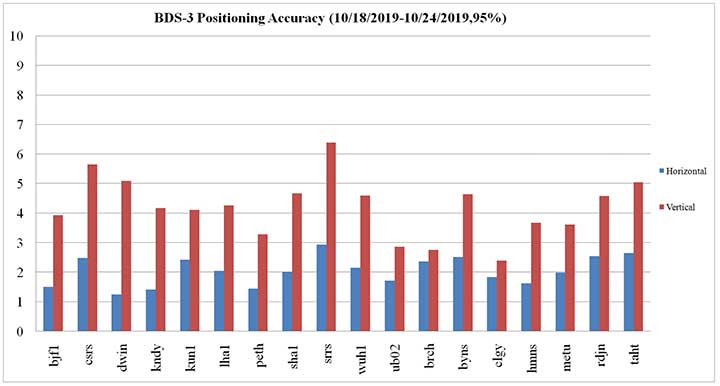
Figure 1 illustrates the spatial signal accuracy of the BDS B1C signal. Figure 2 presents the broadcast orbit accuracy of the BDS B1C signal. Figure 3 showcases BDS’ global positioning accuracy for both single-frequency and dual-frequency.
Through the BeiDou Satellite-Based Augmentation System B1C (BDSBAS-B1C) and the BeiDou Satellite-Based Augmentation System B2a (BDSBAS-B2a) signals, BDS offers single-frequency BDSBAS service that meets APV-I requirements and a dual-frequency multi-constellation service that meets CAT-I requirements for China and surrounding regions. The ionospheric grid model has been persistently refined to enhance the performance of the satellite-based augmentation services at the peripheries. Evaluation results reveal that the BDSBAS service attains a single-frequency positioning accuracy of 1.29 m (95%) horizontally and 1.99 m (95%) vertically, and a dual-frequency positioning accuracy of 0.77 meters (95%) horizontally and 1.41 m (95%) vertically.
BDS disseminates precise orbit and clock difference corrections and inter-code biases via the precise point positioning (PPP)-B2b signal, providing PPP services to China and surrounding areas. Evaluation results indicate that the BDS-only precise point positioning accuracy is 0.16 m (95%) horizontally and 0.22 m (95%) vertically, with a convergence time of less than 20 minutes.
In 2024, building upon its PNT services, BDS actively offers diversified specialized services, including regional short message communication, global short messaging, and international search and rescue. The number of user terminals for regional short message communications continues to grow. Based on inter-satellite links, global short messaging services can provide users with global random-access capabilities. These services have been applied in projects such as the Einstein Probe mission, the SVOM satellite in collaboration with France, and gravitational wave detection satellites, achieving instant return of global detection data. While six medium-Earth orbit (MEO) satellites are equipped with international maritime search and rescue payloads, the BDS return link enables transmission with a communication delay of less than 12 seconds, and a success rate of 96.82%, suitable for distress alert feedback, disaster information broadcasting and other multi-application scenarios.
The stable BDS operation ensures the consistent and rapid improvement of application industries and the expansion of application scenarios. In 2023, the total output value of China’s satellite navigation and location-based service industries reached more than RMB 530 billion, marking a growth of more than 7% compared to 2022.
2. System construction and development
In May 2023, a backup geostationary orbit (GEO) satellite was launched, followed by two additional MEO backup satellites launched in December 2023, featuring upgraded global short message communication capacity and enhanced intelligent payload technologies. These backup satellites have successfully completed in-orbit testing and are now ready to provide services as needed. In September 2024, another pair of MEO backup satellites, equipped with innovative atomic clocks and a new type of inter-satellite links, were deployed. These backup satellites improve system reliability and service performance and facilitate experimental validation for next-generation satellite technology upgrades.
To continuously enhance system service performance, BDS has developed precision and stability enhancement plans for both the ground control system and the in-orbit satellite support system. Efforts include intensifying satellite-based and ground-based multi-source data fusion analysis, conducting regular assessments of constellation and ground system statuses, and improving fault automatic diagnosis, response efficiency, and intelligence capacity.
China is actively promoting the integrated development and experimental validation of BDS and LEO satellite navigation augmentation systems. Leveraging several test satellites within the under-construction LEO constellation, experiments including GNSS+LEO FPPP have been conducted. Results demonstrate that GNSS orbit determination accuracy is better than 5 cm (1σ), and clock error determination accuracy is superior to 0.15 nss (1σ). With signal enhancement from two to three LEO satellites, PPP positioning accuracy reaches 0.3 m with a convergence time at the minute level, thereby enhancing high-precision service performance and reducing PPP convergence time.
In May 2023, China successfully launched the first BDS-3 GEO backup satellite. (Photo: International Cooperation Center of China Satellite Navigation Office)
3. International coordination and cooperation
China has been deeply involved in international satellite navigation. Since 2023, China has actively participated in a series of events under the United Nations framework, including the ICG-17 and the United Nations Workshop on the Application of Global Navigation Satellite Systems, contributing to the global advancement of satellite navigation. China has engaged in deep collaboration with system providers from the United States, Russia and the European Union to facilitate compatibility and interoperability, covering navigation signal structures, time systems, coordinate frameworks, test and assessment. Meanwhile, discussions are held with regional navigation satellite systems and emerging systems on topics of mutual interest, such as high-precision services and emergency alert services. In 2024, the BDS timing service was officially included in the Time Bulletin by the Bureau International des Poids et Mesures (BIPM), signifying international recognition of the ability to provide precise and reliable standard time services globally.
China continues to expand its international partnership with BDS. In recent years, events including the BDS/GNSS Global Partner Forum, the China-Africa BDS Cooperation Forums, the China-Arab States BDS Cooperation Forums, the China-Central Asia BDS Cooperation Forums, the International Training Workshop on BDS Technologies and Applications in the Belt and Road Countries and Regions and the International Summit on BDS Applications have been held to share the benefits of BDS/GNSS applications globally.
BDS will continue to uphold the vision of “a first-class navigation satellite system developed by China and dedicated to the world.” It will make every effort to ensure the stable operation, steady upgrades, and advancements of the system, as well as in-depth research in technologies such as low-orbit PNT and lunar PNT, furthering the commercialization, industrialization, and internationalization of BDS applications
ComNav Technology Ltd. is providing GNSS technology to Africa for projects in land mapping, continuously operating reference station (CORS) construction, precision agriculture and other fields, according to a Feb. 11 article in People’s Daily, the largest newspaper in China.
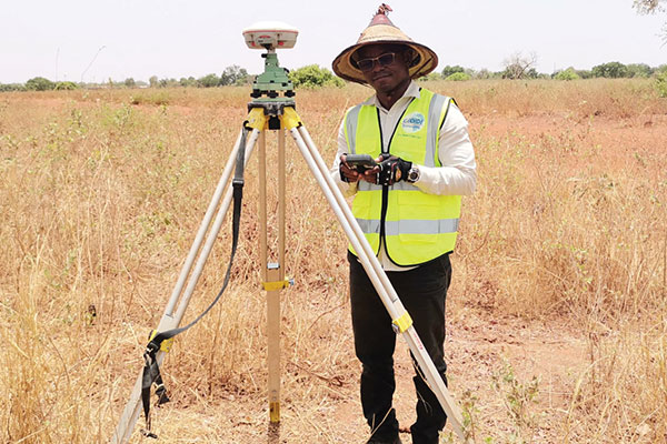
Every day, thousands of users in Africa are using GNSS products, the newspaper stated, highlighting specifically the use of China’s BeiDou satellite navigation system. For instance, CORS using ComNav GNSS/BeiDou receivers have been built in 11 sub-Saharan African countries, including Kenya and Uganda.
Uganda. To meet the demand for high-precision GNSS, the government of Uganda purchased ComNav’s real-time kinematic (RTK) receivers to build its own CORS. Thirty stations have been built so far, creating the most advanced CORS network in East Africa. Its high-precision spatial and temporal information supports land mapping, mining, vehicle management and meteorological monitoring, among other industries.
In 2015, Mulindwa David, chairman of the Uganda Surveying Association, and others visited the Shanghai headquarters of ComNav to learn about its high-precision products and technologies. After training, David and others mastered basic RTK operation and learned simple maintenance.
David used to carry heavy optical equipment every day, but now he only needs to hold a BeiDou receiver to process the relevant data, which has greatly improved his work efficiency and accuracy. “It took at least three days to survey a dozen kilometers of road with optical equipment,” he said. “With BeiDou high-precision receivers, only 10 hours is enough.”
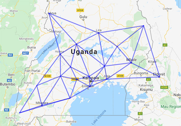
The Uganda CORS network. (Image: ComNav)
Burkina Faso. In response to the COVID-19 outbreak, the Burkina Faso government decided to build a hospital for infectious diseases. In April 2021, it used ComNav GNSS high-precision technology to provide survey data for the hospital’s construction. The land security and topographic surveying tasks were completed in six days, half the time scheduled, said Augustin Bamouni, secretary-general of the country’s national surveying association.
A surveyor in Burkina-Faso surveys the site of a new hospital for infectious diseases. (Photo: ComNav)
Tunisia. The China-Arab BeiDou/GNSS Center is located in the Ghazara Science Park in northern Tunis, the capital of Tunisia. Inaugurated in 2018, it is China’s first overseas BeiDou center, providing satellite navigation training, test evaluation and technical research for African and Arab countries. On average, the center receives real-time data from more than 12 BeiDou satellites at once.
The center will help Tunisia and other African countries train professionals in GNSS technology to support development of the digital economy, according to Amiri Khalil, state secretary in charge of scientific research at Tunisia’s Ministry of Higher Education.
China-Arab BeiDou/GNSS Center is in Tunis, Tunisia. (Photo: ComNav)
China-Africa Forum. The first China-Africa BeiDou System Cooperation Forum was held in November 2021 in Beijing to encourage cooperation between China and Africa and promote use of BeiDou. Four cases from ComNav Technology were described in the forum’s document citing application scenarios of BeiDou in Africa.
ComNav Technology has deepened its cooperation with Africa since China’s Belt and Road Initiative began in 2013. Besides providing products and technologies, ComNav arranged employees to go abroad to provide technical support, traveling to Cameroon, Nigeria, Mali, Zambia, and other African countries. Despite the pandemic, ComNav continues to provide professional service and training both in person and remotely.
The first International Summit on BeiDou Navigation Satellite System (BDS) Applications took place Sept. 16 in Changsha, in central China’s Hunan Province. (Photo/Xinhua)
An enhanced version of the BeiDou short message service was showcased at the First International Summit on BeiDou Navigation Satellite System (BDS) Applications held in Changsha, in central China’s Hunan Province, on Sept. 16, reports China.org.bn.
The short message service enables two-way communication on mobile phones in areas not covered by ordinary mobile communication signals or when base stations are damaged, the website reports. This service would prove useful in the event of an earthquake or other emergencies, as well as offshore fishing.
“Short message service needed a larger satellite terminal such as maritime satellite phone,” said Li Jingyuan, director of the BeiDou short message team at National University of Defense Technology (NUDT). “But the enhanced version’s low-power-consumption feature enables mobile phones to send emergency messages through BeiDou satellites, even without ground mobile communication signals. The information transmission rate of the enhanced version has increased 10 times, which means pictures and voice messages can be sent out quickly.”
At the summit, NUDT, the government of Hunan, and China Electronics Corporation signed an industrial cooperation agreement to further expand short message service to low orbit satellite users. The short-message service could play a role in global satellite internet of things, international life rescue, global emergency communication and other industrial applications, the website reports.
Yang Changfeng, chief architect, BeiDou Navigation Satellite System, speaks at an international event. (Photo: BDS)
On July 31, 2020, BDS-3, the global version of the BeiDou Navigation Satellite System (BDS), was formally commissioned, marking the completion of its three-step development process. BDS enters a new era of global services. With the principle of “serving the world and benefiting mankind,” BDS provides seven types of services to users worldwide, including positioning, navigation and timing (PNT) services, a global short-message communication (GSMC) service, a regional short-message communication (RSMC) service, an international search-and-rescue (SAR) service, the BeiDou satellite-based augmentation system (BDSBAS), the BDS/GNSS ground-based augmentation system (BDGAS), and the precise point positioning (PPP) service. BDS has been continuously making contributions to improving GNSS capabilities and promoting the development of GNSS applications and technologies.
In 2020, as BDS construction was successfully completed, BDS has made fruitful achievements in application development and internationalization.
System Construction
Space Constellation Deployment. From March to June 2020, two BDS-3 GEO satellites were launched, while the in-orbit tests of two IGSO satellites, two GEO satellites, and two MEO satellites were completed. As the result, the global system constellation was successfully deployed.
By the end of October 2020, 45 in-orbit operational BDS satellites provide services to global users, including 15 BDS-2 satellites and 30 BDS-3 satellites.
Ground System Development. More than 40 new ground stations have been built, tested and commissioned. The BDS ground system is operating stably, supporting daily BDS operations.
Basic Service Enhancement
Generally speaking, the accuracy of the BDS signal-in-space is better than 0.5 m, BDS global positioning accuracy is better than 10 m, BDS velocity measurement accuracy is better than 0.2 m/s, and BDS timing accuracy is better than 20 ns. In the Asia-Pacific region, BDS positioning accuracy is better than 5 m, the velocity measurement accuracy is better than 0.1m/s, and timing accuracy is better than 10 ns.
In the key service area, there are 30 BDS-3 satellites and 15 BDS-2 satellites that jointly provide the services using B1I and B3I signals. The actual average measured positioning accuracies are about 1.48 m horizontally and 2.99 m vertically (95% confidence), which are improvements of about 30% and 5% respectively as opposed to solely relying on the BDS-2 system.
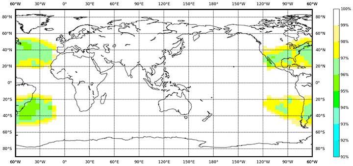
Globally, with the B1I, B3I, B1C and B2a signals, BDS-3 offers service availability of 100% (PDOP ≤6,). The actual measured positioning accuracies are about 1.54 m horizontally and 2.65 m vertically (95% confidence).
Featured Services Benefit Users
Presently, the BDS PPP service covers China and its surrounding areas. By broadcasting the high-precision orbit and satellite clock error corrections through the B2b signal, the high-precision positioning service is provided, while initial testing measurements show that the positioning accuracies are about 0.18 m horizontally and 0.26 m vertically (95% confidence).
BDSBAS was developed in accordance with International Civil Aviation Organization (ICAO) standards to provide SBAS services with superior accuracy and integrity, enabling aircraft approach with vertical guidance of class I (APV-I). The BDSBAS services cover China and its surrounding areas, and the SBAS data, following ICAO standards are broadcast by the three BDS GEO satellites. In particular, the single frequency SBAS service is being provided through the BDSBAS-B1C signal. At the moment, the civil aviation certification process of the BDSBAS SF service is being prepared. The BDSBAS-B2a signal will provide the Dual Frequency Multiple Constellation (DFMC) SBAS service. BDS has been actively participating in the development process of the DFMC standards and carrying out the verification of the draft DFMC SBAS Standard and Recommended Practices.
BDGAS consists of 155 framework reference stations and nearly 2,200 regional stations in China. The system carries out high-precision applications in many fields, such as surveying and mapping, land resources, earthquake monitoring, transportation and meteorology. Its basic services include real-time positioning at the meter, decimeter and centimeter levels, as well as precise post-processing positioning at the millimeter level.
Being developed in accordance with Cospas-Sarsat standards, the BDS MEO-SAR service provides the detection probability of the international search-and-rescue service of better than 99%, with the characteristic return link capability. In July, a joint test was carried out using the BDS MEO-SAR satellites with the Cospas-Sarsat ground station in Maryland, U.S., and the relevant technical documents and the equipment admittance testing reports were formally submitted to Cospas-Sarsat, which provides Chinese contributions to the international MEO-SAR family.
RSMC provides service to China and its surrounding areas through three GEO satellites. Its communication capability is greatly improved compared to BDS-2. With service capacity of 12 million times per hour, the transmitting power of user terminals is reduced to 1-3 W and the single message capacity reaches 1,000 Chinese characters. The construction of the RSMC service platform has been completed to promote the organic integration of short message and mobile communication services, and to further exert the advantages of the BDS featured services.
GSMC provides global services through 14 MEO satellites with single message capacity of 40 Chinese characters.
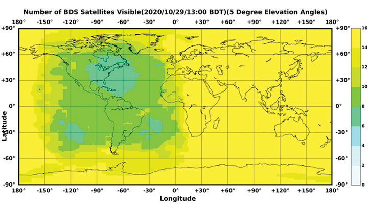
Figure 1. The number of visible BDS satellites as of BDT 13:00, Oct. 29, 2020. The number of visible satellites at Asia-Pacific Region is greater than 20. (Source: www.csno-tarc.cn)
Integrated Applications
As the system construction accelerates, BDS is also making great efforts to strengthen the development of BDS fundamental products and promote large-scale applications in various fields. The integrated applications and innovative development adopt the “BDS+” and “+BDS” models to improve quality and efficiency as well as to stimulate a healthy and fast-growing GNSS industry.
Fundamental Products. At present, the fundamental BDS products have been used in areas such as mass-market applications, where the performance has reached or is close to the world-class level. Progress has been made in the research and development of multi-system baseband-RF integrated high-precision chips. The 28 nm chips have been mass-produced, and the 22 nm chips are about to be mass-produced. As a result, the function and performance of the chips will reach a new level. The BDS navigation chips, modules, high-precision boards and antennas have been exported to more than 120 countries and regions, serving millions of users worldwide.
Industrial Applications. BDS has been widely used in various fields, including communication and transportation, public security, agriculture, forestry, animal husbandry and fishery, hydrological monitoring, meteorological forecasting, time synchronization, power dispatching, and disaster prevention and mitigation. Significant economic and social benefits have been generated.
In the field of transportation, in the first three quarters of 2020, more than 7 million road vehicles were using BDS. The number of postal and express delivery vehicles using BDS reached 314,000, and the number of ships is about 1,369. In general aviation, 300 planes are using BDS.
In agriculture, BDS-based automatic steering systems are on more than 45,000 pieces of agricultural machinery and equipment, saving 50% of the labor cost. BDS-based agricultural machinery operation supervision platforms are serving 10 million units of agricultural machinery equipment, greatly improving management and operational efficiency.
In forestry, the BDS positioning and short message communication services are widely used in forest fire prevention, natural forest protection, forest inspection, pest control and so on.
In the fishery field, BDS provides fishery managers and fishing vessels with ship position monitoring, emergency rescue, information dissemination, vessel management and other services. BDS terminals have been installed on more than 70,000 fishing boats and law enforcement vessels in China. More than 10,000 people have been saved.
For disaster prevention and mitigation, a three-level platform covering the national ministries and the provinces was built to offer six-tier application services, deploying more than 45,000 BDS terminals.
BDS plays an important role in the emergency response to major disasters such as flooding in South China and forest fire in Southwest China this year. BDS is accelerating entry into new infrastructural construction, and is deeply integrated with new technologies such as next-generation communication, blockchain, the internet of things, artificial intelligence, and more. New modes, formats and markets for BDS applications are constantly emerging.
Mass-Market Applications. BDS-based navigation and positioning services have been adopted by various enterprises in the fields of e-commerce, smart mobile terminals, location-based services, the sharing economy and people’s livelihood, profoundly changing people’s production and lifestyles. Just like water and electricity, BDS provides public services that are easily accessible and available on demand. In smartphone applications, domestic and international mainstream chip manufacturers have released communication-navigation integrated chips compatible with BDS. More than 90% of mobile-phone companies applying for access to China’s domestic network support BDS positioning. Smartphones from Huawei, MI, Apple, VIVO, OPPS and other big brands in China are BDS-enabled.
BDS Standards. The updating and upgrading of the BDS standard system is progressing smoothly, with Version 2.0 to be released soon. The BDS application standard systems will be published in electric, railway and other industries. The revision of the national BDS standards is advancing steadily. Four national standards were issued in early 2019, and 28 national standards will be released by the end of 2020. Forty-two standards related to the BDS program have been issued in three batches, while 58 new standards are being formulated.
The work related to BDS intellectual properties is being carried out, and various innovation entities continue to improve BDS’ intellectual property creation, utilization and protection capabilities. Statistics shows that Chinese GNSS-related patent applications reached 12,170 in 2019 and 9,411 by the end of October, with an average growth rate of 21.7% in the past three years.
International Cooperation
Bilateral Cooperation. BDS continues to carry out bilateral cooperation with other GNSS to promote compatibility, interoperability and joint applications. Under the China-U.S. civil GNSS cooperation platform, working groups have been set up to continuously engage in cooperation and exchanges in areas such as compatibility and interoperability, augmentation systems and aviation applications, civil service provisions, etc. China and the Russian Federation held their seventh bilateral meeting in October, and have been pushing forward landmark demonstration projects such as joint ground station set-up, cross-border transportation and precision agriculture. China and the European Union are carrying out coordination, exchanges and cooperation under the framework of the China-EU space cooperation dialogue.
Multilateral Cooperation. The BDS team participates in meetings of the International Committee on Global Navigation Systems (ICG), and continuously promotes discussions on relevant topics. The experience fighting COVID-19 using BDS/GNSS, as well as BDS applications in pandemic prevention and control, are being shared with the international GNSS community. During the ninth ministerial meeting of the China-Arab States Cooperation Forum held in July, video conferences promoted the deepening of China-Arab satellite navigation cooperation.
International BDS Applications. With the export of BDS high-precision products, BDS is widely used in different regions and fields, such as land registration, precision agriculture, warehouse logistics in ASEAN countries, construction in Western Asia, airport timing and plying the seas in South Asia, power plant inspections in Eastern Europe, and land surveys in African countries. BDS high-precision products are exported to more than 120 countries and regions. BDGAS technologies and products are systematically exported, serving more than 100 million users worldwide.
International Standards. BDS has been adopted by many international organizations including the ICAO, the International Maritime Organization, Cospas-Sarsat and mobile communication. A number of international standards supporting BDS have been released. In March, the International Electrotechnical Commission (IEC) officially issued the first international standard for BDS vessel receiving equipment inspection (IEC 61108-5), which provides the basis for global classification societies to carry out type certification of BDS equipment on vessels. In July, the first batch of 3GPP standards supporting the BDS B1C signal was officially released. The series of standards will support BDS signals in Assisted GNSS (A-GNSS) of 5G communication. By year’s end, the Radio Technical Commission for Maritime Services (RTCM) 10403.X standard, which fully supports BDS, will be officially released, marking an important milestone in the creation of a general data format standard for BDS receivers.
Adhering to the development concept of “the Chinese BDS, the World’s BDS and the First Class BDS,” BDS development vigorously carries forward the Beidou spirit in the new era — independent innovation, open integration, unity and pursuit of excellence. By 2035, a more ubiquitous, integrated and comprehensive national PNT system with a spatial-temporal information service infrastructure covering space, sky, Earth and sea, and offering unified high precision, high intelligence, high security and high efficiency, will be built. It will provide core support for future intelligent and unmanned development; continuously promote system upgrading; integrate new technologies such as new generation communication and low orbit augmentation; strive to develop high-quality capabilities such as quantum navigation, full-source navigation, and micro PNT; and build a spatial-time information service infrastructure covering space, sky, Earth and sea, with high precision, high intelligence, high security and high efficiency.
Yang Changfeng, Chief Architect, BeiDou Navigation Satellite System. (Photo: BeiDou)
By Yang Changfeng Chief Architect, BeiDou Navigation Satellite System
As one of the core Global Navigation Satellite Systems (GNSS) providers, the BeiDou Navigation Satellite System (“BDS”) has been developed steadily following a three-step strategy. BDS has been providing global services since the end of 2018. By around 2020, the BDS-3 system will be entirely completed to provide global users with free, open and high-quality navigation, positioning, timing, short message communication and other services. A more ubiquitous, integrated and intelligent positioning, navigation, timing system will be built before 2035.
In 2019, BDS has progressed with regard to aspects of system construction, integrated applications and international development.
System Construction
Accelerating Satellite Deployment. From January to November 2019, three BDS-3 satellites in inclined geosynchronous satellite orbit (IGSO) and four satellites in medium Earth orbit (MEO) were launched, and one IGSO satellite has completed in-orbit tests, to further improve the global system constellation.
The last two MEO satellites are planned to be launched by the end of 2019, marking the completion of the BDS core global constellation deployment. By June 2020, another two GEO satellites will be launched, and the full deployment of the BDS-3 system will be completed.
Ground System Construction. In 2019, 12 new ground operation and control stations (including one uplink station and 11 class-II monitoring stations) have been built, to complete the satellite-ground joint debug and integration tests, and the overall operation of the system is stable.
By the end of October 2019, 34 BDS satellites are operating in orbit to provide services to global users, including 15 BDS-2 satellites and 19 BDS-3 satellites.
Improving Service Performance
Key Service Areas. In May 2019, the last BDS-2 backup satellite was launched to further improve the performance in the key service areas of the BDS-2 system. As the BDS-3 satellites go into operation, the accuracy and availability of the BDS B1I and B3I signals, in the BDS-2service area, has been improved by about 30% and 5% respectively, compared with that of solely relying on the BDS-2 system.
Global Service Areas. The BDS B1I and B3I service areas have been expanded from the Asia Pacific region to the world, and the accuracy and availability have been further improved. With the condition of PDOP ≤6, the availability is better than 99% in most regions all over the world (in parts of the United States, better than 97%). In the global area, the mean value of the actual measured positioning accuracy is about 3.6m horizontally and 6.6m vertically, velocity measurement accuracy is about 0.05m/s, and timing accuracy is about 9.8 nanoseconds (95% confidence). So far, the BDS-3 new signals, B1C and B2a, have possessed service capacity worldwide. The system availability is better than 87%, in the condition of PDOP ≤ 6. The mean value of the actual measured positioning accuracy is about 2.4m horizontally and 4.3m vertically, velocity measurement accuracy is about 0.06m/s and timing accuracy is about 19.9 nanoseconds (95% confidence).
Building of the Featured Capacity. The BDS/GNSS ground based augmentation system has been providing basic services. It consists of 155 framework reference stations and nearly 2,200 regional stations in China. The system has carried out high-precision applications in many fields, such as surveying and mapping, land resources, earthquake, transportation and meteorology. Its basic services include real-time positioning at the meter, decimeter and centimeter level, as well as precise post-processing positioning at the millimeter level.
The BeiDou Satellite-Based Augmentation System (BDSBAS) is being developed in accordance with International Civil Aviation Organization (ICAO) standards to provide navigation services with superior accuracy and integrity. In 2019, the first GEO satellite with the BDSBAS payload has been tested in orbit and the satellite is in good condition.
Integrated Applications
As the system construction accelerates, BDS is also making great efforts to strengthen the development of the fundamental products and applications in various fields. The integrated applications adopt the “BDS+” model to stimulate the growth of satellite navigation industry.
Fundamental Products. At present, the fundamental BDS products have been used in such areas as mass market applications, of which the performance has reached or is close-to the world-class level. The development of full-frequency integrated high-precision chips is near its completion, and the performance of the BDS chips will improve further. By the end of 2019, BDS navigation chips, modules and antennas have been exported to more than 100 countries and regions. In 2018, the domestic output value was more than RMB 300 billion (US$43 billion), in which the BDS contribution exceeds 80%.
Industrial Applications. BDS has been widely used in various fields — communication and transportation, public security, agriculture, forestry, animal husbandry and fishery, hydrological monitoring, meteorological forecast, time synchronization, power dispatching, disaster prevention and mitigation — generating significant economic and social benefits. In the field of transportation, by September 2019, more than 6.47 million road operating vehicles and 42,300 postal and express delivery vehicles in China are using BDS, and the world’s largest dynamic supervision system of operating vehicles has been formed, which effectively improved management efficiency and road transportation safety.
In agriculture, a BDS-based automatic driving system has been equipped on more than 20,000 sets of agricultural machinery and equipment, saving 50% of the labor cost. The BDS-based agricultural machinery operation supervision platform and the IoT platform has been serving 10 million units of agricultural machinery equipment, greatly improving management and operational efficiency.
In disaster prevention and mitigation, a tri-level platform covering the national ministry, the provinces, and cities and counties has been built to offer six-tier application services, with more than 45,000 terminals using BDS. The BDS/GNSS high-precision technologies have been applied in the field of geological disaster monitoring, while the landslides in Gansu province have been successfully forecast repeatedly, with time accuracy at the second level and deformation accuracy at the millimeter level.
Mass Market Applications. The BDS-based navigation and positioning services have been adopted by various enterprises in the fields of e-commerce, smart mobile terminal manufacture, location-based services (LBS), the sharing economy and the mass market, thereby changing people’s production and life style profoundly. Mainstream manufacturers in China and around the world have introduced BDS-compatible chips that integrate communication and navigation functions.
According to Chinese market statistics, in the third quarter of 2019, 151 types of mobile phones applying for license have positioning functions, among which 110 models support BDS. Using BDS/GNSS ground based augmentation stations, the spatial-temporal services including centimeter-level positioning, millimeter-level perception and nanometer-level timing services can be provided, while the accelerated positioning services cover 220 countries and regions with more than 390 million global users.
International Development
Bilateral Cooperation. BDS continues to carry out bilateral cooperation with other navigation satellite systems, to promote compatibility and joint applications. China and the United States have set up joint working groups in areas such as compatibility and interoperability, augmentation systems and civil services to continuously develop cooperation and exchanges.
China and the EU set up a technical working group on the compatibility and interoperability between the BDS and Galileo systems to carry out coordination, exchanges and cooperation, under the framework of the China-EU space cooperation dialogue and the International Telecommunications Union (ITU). The agreement between the Government of the People’s Republic of China and the Government of the Russian Federation on Cooperation in the Field of the Use of BeiDou and GLONASS for Peaceful Purposes has come into effect.
In August 2019, China and the Russian Federation held their sixth bilateral meeting in Kazan, Russia, signed the site survey certificate of GNSS monitoring stations, and achieved many cooperation results. In addition, the bilateral cooperation with Iraq, Tunisia and Saudi Arabia has also been steadily promoted.
Multilateral Cooperation. During the 62nd session of the Committee on the Peaceful Uses of Outer Space (COPUOS) in June 2019, an exhibition on ancient Chinese navigation technologies was held at the Vienna International Center with the theme “From Compass to BeiDou,” which vividly demonstrated China’s brilliant achievements in timing, mapping, cartography and navigation science and technology. In April and October, 2019, the second China-Arab States BDS Cooperation Forum and China-Central Asia BDS cooperation forum were held in Tunis and Nanning, China, respectively, to promote the BDS to serve the Arab region and Central Asian countries.
The BDS Overseas Applications Were Steadily Promoted. With BDS high-precision products being exported, BDS has been widely used in different regions and fields, such as land registration, precision agriculture, warehouse logistics in ASEAN countries, construction in Western Asia, airport timing and piling at seas in South Asia, electric power inspection in Eastern Europe, and land survey in African countries. As BDS-3 system continues to improve construction, it will provide quality services for more people in a wider area.
Ratification of BDS by International Standards. BDS has made a clear schedule to be ratified by the ICAO standards in 2020. It has formulated 26 standards in the field of international mobile communication based on the BDS B1I signal, and other standards based on the B1C and B2a signals are being developed. A receiver positioning result output protocol (NMEA0183) and a receiver data exchange format (RINEX 3.04) supporting BDS are to be released. Technical parameters and index information of BDS search and rescue (SAR) payloads are included in relevant COSPAS-SARSAT documents, and the development and in-orbit test of the first batch of SAR payload has been completed. The first BDS standard in the International Electrotechnical Commission (IEC) has been developed and approved and is expected to be released in June 2020.
Future Plans
After BDS achieves global service capabilities by 2020, it will further improve global navigation, positioning, timing and regional short-message communication services, and finalize global short-message communication, international search and rescue, satellite-based augmentation, precise point positioning, and other service capabilities. China’s BDS will contribute Chinese solutions to the world, and give full play of its role, with a renewed attitude, stronger capabilities and better services, to serve the world and benefit humankind.
China’s super-thin rubidium atomic clock, which is just 17 millimeters thick, has been put into mass production, according to Xinhua News Agency.
The clock, developed in 2018 by a research institute under the China Aerospace Science and Industry Corp. Ltd, (CASIC) is the key to the positioning and timing accuracy of BeiDou navigation satellites.
In 2015, Chinese scientists developed a rubidium clock that is tiny enough to fit in the palm of your hand but was almost 40 millimeters thick. The new clock, with a length of 76 millimeters and width of 76 millimeters, is only 17 millimeters thick.
Compared with the previous generation, the new clock is smaller in size but performs better. It adopts a plug-in design, making it easy to insert and remove on circuit board. With stronger resistance to high temperatures, it can work at 70 degrees Celsius (158 degrees Fahrenheit).
In addition, it has a taming function, enabling the clock to be automatically recognized and tamed by the pulse per second (PPS) signal provided by navigation satellite systems, improving the accuracy of local frequency.
The clock can be used in fields such as aviation, aerospace and telecommunications. According to its developers, the ultra-accurate clock will have a broader market prospect in the future.
Atomic clocks are the most accurate time and frequency standards. They use vibrations of atoms to measure time. Due to its small size, low cost and high reliability, rubidium clock is the most widely produced atomic clock.
A large number of self-developed rubidium and hydrogen atomic clocks have been carried by satellites that provide accurate positioning for China’s BeiDou Navigation Satellite System.
The atomic clocks are the workhorses that send synchronized signals so sat-nav receivers can triangulate their position on Earth.
China began to construct the BDS in the 1990s. The system started serving China with its BDS-1 satellites in 2000 and started serving the Asia-Pacific region with its BDS-2 satellites in 2012. China will complete the BDS global network by 2020.
A Chinese cargo ship, the Rongda Changsha, equipped with receivers downloading signals from the BeiDou Navigation Satellite System (BDS), arrived at Brunei, on the north coast of the island of Borneo in Southeast Asia, in February after embarking from Luojing Port in Shanghai. This marks the first public successful application of BeiDou terminal products in the South China Sea and unveils China’s ambition to promote BeiDou products in the international marketplace.
The Shanghai-Brunei trip was a trial for not only examining BeiDou-3’s capacity, but for learning the users’ experience and needs. The data collected from the trip has been analyzed and applied for updating and prioritizing the marine navigation system, according to China Aerospace Science and Technology Corporation (CASC), manufacturer of the Beidou receivers on the ship.
It is anticipated that more services will soon arrive, with Internet and voice calls facilitated by the messaging aspect of BDS, for further exploring industrial application scenarios and — importantly for government support of its GNSS — protecting Chinese outbound and inbound routes. The South China Sea is one of the world’s busiest waterways, and oil imports to China from the Middle East are a key strategic component of this traffic activity.
BDS now covers more than 50 countries and more than 3 billion people. BDS-related products have gained access to the markets of more than 70 countries and regions, more than 30 of which are along the (land-based) Belt and (maritime) Road, in line with the Belt and Road Initiative. Through joint applications with other compatible navigation satellite systems, BDS provides global users with diversified choices for better application experience.
“Chinese security interests encompass not only China itself and nearby areas, but also the sea lanes that enable the import of raw materials and export of finished goods,” wrote Scott Pace in GPS World, December 2010. “In recent years, China has shown an increasing interest in ‘maritime domain awareness,’ in which satellite navigation is used for monitoring the transit of ships in the Indian Ocean (for example, oil from the Middle East) and the South China Sea (minerals from Australia, fishing zones). Satellite navigation is a dual-use, commercial and military, interest for China, and this may have prompted support for the more advanced, independent GNSS that would become Beidou-2 or Compass.”
Pace was chosen by the White House to serve as executive secretary of the National Space Council in July 2017. Pace is also director of the Space Policy Institute and Professor of Practice of International Affairs at George Washington University. He serves as a special counselor to the National Space-Based Positioning, Navigation and Timing (PNT) Advisory Board.
China successfully sent twin BeiDou navigation satellites into space on Aug. 25, aboard a single carrier rocket, according to news reports. The satellites are numbers 35 and 36 in the BeiDou navigation constellation.
China launched two more BeiDou satellites on Aug. 25. (Photo: CCTV)
China successfully sent twin BeiDou navigation satellites into space on Aug. 25, aboard a single carrier rocket, according to news reports. The satellites are numbers 35 and 36 in the BeiDou navigation constellation.
Only a few weeks ago, China launched another pair of BeiDou-3 navigation satellites.
The Long March-3B carrier rocket lifted off from Xichang Satellite Launch Center in Southwest China’s Sichuan Province at 7:52 a.m. local time.
This was China’s 23rd orbital launch this year, surpassing the national record of 22 launches set in 2016. China Aerospace Science and Technology Corporation (CASC), the main contractor for the space program, is planning on 35 launches this year.
China launched two more BeiDou satellites on Aug. 25. (Photo: CCTV via Weibo)
The first overseas center for China’s BeiDou Navigation Satellite System (BDS) was inaugurated in Tunis, Tunisia, on April 10, according to the Xinhua News Agency.
The China-Arab States BDS/GNSS Center was established as a pilot project between China and the Tunisia-based Arab Information and Communication Technology Organization (AICTO), an Arab governmental organization under the Arab League, to promote the global application of BeiDou, said Ran Chengqi, director of the China Satellite Navigation Office.
“The center could serve as both a window to showcase the BDS, and a platform for promoting international exchanges and cooperation,” Ran said.
Mohamed Ben Amor, secretary general of AICTO, hailed the center as a unique technology project for the Arab region and the entire world. AICTO will “intensify its cooperation with China in the field of satellite navigation to boost technological advance and economic development in the region,” Amor said.
The BeiDou pilot project will help train satellite navigation scientists and develop digital economy in Arab countries, according to Khalil Amiri, Tunisia’s secretary of state for scientific research. “We are working closely with China to effectively access and develop win-win database services via BeiDou and other satellites for various uses,” Amiri said.
Ran (left front) and Amor shake hands during the inauguration ceremony of the China-Arab States BDS/GNSS Center in Tunis. (Photo: Xinhua)
China launched twin BeiDou-3 navigation satellites into space on Jan. 12 as part of efforts to enable its BeiDou system to provide navigation and positioning services to countries along the Belt and Road by the end of 2018, reports XinhuaNet.
China’s Belt and Road Initiative aims to create the world’s largest platform for economic cooperation.
The pair of satellites was launched at 7:18 a.m. local time aboard a Long March-3B carrier rocket from Xichang Satellite Launch Center in southwest China’s Sichuan Province. The twin satellites are coded the 26th and 27th satellites in the BeiDou Navigation Satellite System.
This is the first launch of the BeiDou satellites in 2018, which will see intensive launches throughout the year.
The twin satellites are coded MEO-7 and MEO-8, the 26th and 27th satellites in the BeiDou Navigation Satellite System.