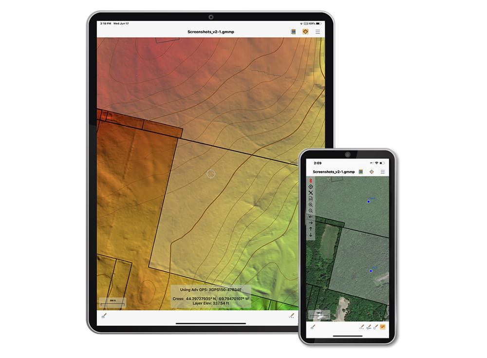
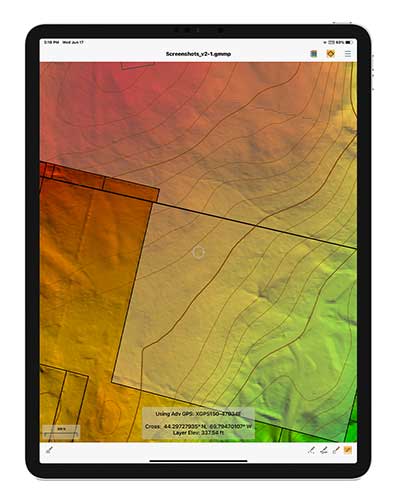
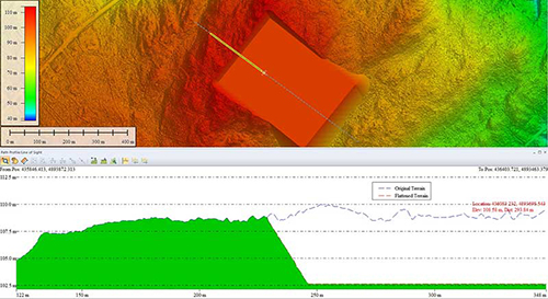
The Global Mapper Mobile Pro Module has always included the ability to connect to external GPS devices, but version 2.3 expands this to include support for any GNSS device that uses TCP/IP communication. Additionally, this mobile update provides Global Mapper analysis tools for volume calculation and viewshed for terrain data.
The mobile application of Global Mapper allows users to take the desktop functionality and existing data into the field for easy and accurate data collection and light processing. Since 2016, Global Mapper Mobile has been a user-friendly tool for capturing field data with portable iOS and Android mobile devices.
Version 2.3, available in both the free and Pro versions, adds many updates and improvements to the application, including the option to record and save voice memos to vector features and add multiple field-captured images to a feature. Autosave now prevents the loss of changes made to a map.
“Expanding user functionality in the field was the main focus of this release. Users of the base version of the application can utilize voice memos and the ability to save multiple photos to features for a more complete recording of field data,“ said Jeffrey Hatzel, Global Mapper Mobile product manager. “The Pro Module adds TCP/IP communication for external GNSS devices, expanding the list of compatible third-party devices. The addition of tools for volume calculation, viewshed analysis, and expanded projection support allows for even more workflows to be completed within the app.”
Blue Marble Geographics has released version 22.1 of Global Mapper, a GIS application that provides both novice and experienced geospatial professionals with a comprehensive array of spatial data processing tools.
Globe Mapper provides access to a variety of data formats and includes numerous spatial analysis tools at a genuinely affordable price.
The version 22.1 release includes enhancements to the software’s 3D Viewer including, a new Save 3D Views function and 3D View navigation tools to target the camera on specific features and lock the pivot axis around a feature of interest.
The data graphing and charting feature has been updated with support for creating graphs from multiple layers, and several new spatial operations functions have been added, including Union and Difference. As with previous releases, numerous new data formats are now supported including, support for exporting to COG (Cloud-Optimized GeoTiff) format and importing of IFC (Buildings) and GeoSLAM files.
“Every release of Global Mapper demonstrates Blue Marble’s commitment to continually expanding our software,” said Patrick Cunningham, Blue Marble President and CEO. “Version 22.1 includes countless improvements throughout the software but especially in 3D visualization and analysis, reflecting the rapidly increasing importance of 3D mapping.”
Blue Marble Application Specialists will be conducting a live webinar on Global Mapper v22.1 on March 3. During the hour-long presentation, scheduled to begin at 10 a.m. (U.S. Eastern Time), attendees will see the latest tools in action and will have the opportunity to ask questions about the new functionality. Registration is required.
A roundup of recent products in the GNSS and inertial positioning industry from the September 2020 issue of GPS World magazine.
OEM
Inertial sensors
Includes four models
Photo: SGB Systems
The third-generation Ellipse series has a 64-bit architecture, allowing high-precision signal processing. All of the INS/GNSS devices now embed a dual-frequency, quad-constellation GNSS receiver for centimetric position and higher orientation accuracy. The Ellipse-A is a motion sensor; Ellipse-E provides navigation with an external GNSS receiver; Ellipse-N is a single-antenna RTK GNSS/INS; and Ellipse-D is a dual-antenna RTK GNSS/INS. With its new 64-bit architecture, the third-generation Ellipse series enables the use of high-precision algorithms and technology used in high-end inertial systems such as rejection filters and FIR filtering.
The PNT-6220 Assured Reference combines low-Earth-orbit (LEO) signals, GNSS, terrestrial, wireline and atomic clock services in one small solution for critical infrastructure applications. The PNT-6220 seamlessly combines concurrent L1, L2, L3 and L5 GNSS reception with a LEO-based Satellite Time and Location (STL) timing receiver. It also includes terrestrial receivers and PTP/IEEE-1588 edge grandmaster and PTP/IEEE-1588-slave capability. It provides assured PNT for critical infrastructure applications such as those described in the directives of Presidential Executive Order 13905. It can serve as a timing reference for 5G equipment, an ePRTC-capable reference, or a high-performance disciplined reference that supports PTP/IEEE-1588, STL, RF distribution and multi-frequency GNSS capability. The PNT-6220 can automatically select the most optimal UTC reference input and switch over among its numerous reference inputs if one or more are jammed or spoofed, as well as average several references for additional stability and accuracy.
Jackson Labs Technologies, jackson-labs.com
GNSS Receiver
Integrates correction service
Photo: Septentrio
The AsteRx-m2 Sx OEM board provides a GPS/GNSS receiver with always-on sub-decimeter accuracy without the need for additional correction service subscriptions. GNSS corrections are automatically streamed to the receiver. The integration enables plug-and-play positioning with high accuracy available out of the box. The AsteRx-m2 Sx is an efficient positioning solution for small robots, aerial drones and automation applications. Advanced anti-jamming technology AIM+ ensures robust and reliable operation in challenging environments, even in the presence of RF interference.
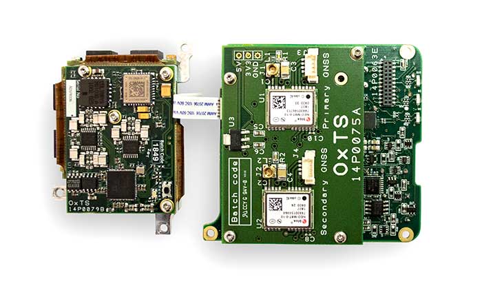
The xOEM v3 inertial navigation system includes the architecture from the company’s IP65-encased xNAV v3 as well as a full range of software interfaces, providing integrators maximum configuration flexibility, real-time monitoring, post-processing and analysis. Software interfaces can be customized using the OxTS NAVsuite. Plugins can be created using the company’s NAVsdk, allowing the xOEM v3’s software to be easily packaged and included as part of a product.The high-grade MEMS inertial sensors and real-time kinematic (RTK)-capable GNSS receiver within the xOEM v3 board set deliver high performance capabilities. The board set provides 0.1° heading accuracy, 0.05° pitch/roll accuracy and 2 cm global position accuracy. The board set is compact at 150 grams, which enables manufacturers to seamlessly integrate and build a high-performance INS into their products, such as commercial mapping applications on land and in the air. Its light weight means more payload capacity for other critical components. An add-on lidar georeferencing software package is also available with a sophisticated boresight calibration tool.
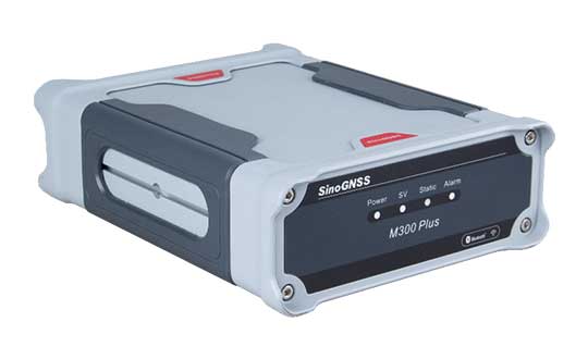
The M300 Plus GNSS receiver is designed to supplement the company’s M300 Pro, which is aimed at clients who need a more economical version for their CORS networks. The M300 Plus is also designed for monitoring projects and other applications. By using a powerful, adaptive detecting and canceling technology, the M300 Plus provides enhanced anti-jamming capability, which is critical for a reference station providing reliable GNSS data. Its built-in web server provides remote control of receiver configuration, status, firmware update and data download. It uses a 4G module as an internet backup, enhancing the stability of data connections.
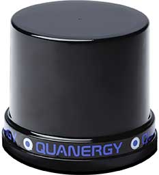
The MQ-8 family — 3D lidar sensors and perception software — are part of Quanergy’s Flow Management platform. Designed with a new smart beam configuration, the MQ-8 solution delivers up to 140 meters of continuous tracking range, enabling up to 15,000 m2 of coverage with a single sensor. It is suitable for flow management applications such as security, smart city, social distancing and smart space industries.
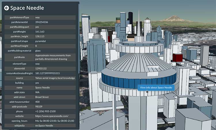
Cesium OSM Buildings expands the company’s suite of Global Base Layers including worldwide terrain, aerial imagery and streetmaps already available. With the new layer, 3D buildings can be visualized, styled and analyzed in an efficient and interoperable manner using 3D Tiles, the open standard developed by Cesium to stream massive 3D geospatial datasets. The layer gives geospatial developers urban context to 3D applications. The buildings are created for efficient visualization and are streamable to any device with 3D Tiles.Cesium OSM Buildings are derived from OpenStreetMap. Buildings are also regularly updated, firmly clamped to terrain, and individually selectable and styleable.
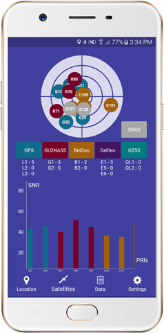
Version 2.1 of Global Mapper Mobile provides updates to both the free and Pro versions. The iOS and Android applications are designed for viewing and collecting GIS data, and provide situational awareness and location intelligence for remote mapping projects. A complement to the desktop version, the mobile app can display all supported vector, raster and elevation data formats. The release improves vector feature styling, terrain layer support and layer transparency setting. In the Pro version, it introduces advanced GPS support, allowing users to connect to external, high-accuracy Bluetooth GPS devices from vendors such as Eos Positioning and Bad Elf. It also allows access to detailed information including the satellite constellation, precise location information and the raw NMEA stream.
The AiRXOS Enterprise Energy Solution provides digital compliance, situational awareness of airspace and assets, inspection, emergency response/disaster recovery capabilities, analytics and asset performance tools in a connected platform. It runs on AiRXOS’ Air Mobility Platform — a secure, cloud-based, extensible platform that enables integration of an energy organization’s current applications and other UAS service suppliers. It brings all UAS lifecycle operations into one view, including infrastructure inspection, asset and crew management, and emergency operations after a natural disaster.
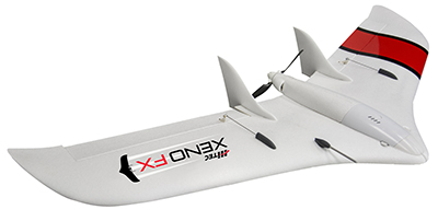
The Xeno FX is a fixed-wing platform optimized for efficient and cost-effective area survey and monitoring missions. Users can program the flight plan before launch to ensure thorough coverage of a target region. The fixed-wing design allows for efficient cruise and maximum time aloft. The Safe Launch protective feature means the propeller starts spinning only after the airframe has been safely hand launched. A quick-change modular payload system allows users to reconfigure their data-acquisition hardware for multiple missions. Constructed of Multiplex’s resilient Elapor foam, the folding wings make for compact storage and easy transport.
Blue Marble Geographics has released version 2.1 of its mobile mapping application Global Mapper Mobile, with updates to both the free and Pro versions.
Global Mapper Mobile is an iOS and Android application for viewing and collecting GIS data. It utilizes the GPS capabilities of mobile devices to provide situational awareness and locational intelligence for remote mapping projects.
A complement to the desktop version of Global Mapper, the mobile edition can display all of the supported vector, raster, and elevation data formats and offers a powerful and efficient data collection tool. The latest release includes improvements to its vector feature styling, terrain layer support, and layer transparency setting.
For advanced field mapping functionality, the latest release of the optional Pro version (available for purchase) introduces advanced GPS support. This allows users to connect to external, high-accuracy Bluetooth GPS devices from vendors such as Bad Elf and EOS, among others, directly from Global Mapper Mobile, allowing users to access detailed information including the current satellite constellation, precise location information and the raw NMEA stream.
“Global Mapper Mobile v2.1 brings exciting new functionality to the application, much of which was highly driven by user requests and feedback,” said Jeffrey Hatzel, senior application specialist at Blue Marble Geographics.
Blue Marble’s GIS software is used by hundreds of thousands of satisfied customers throughout the world who need affordable, user-friendly, yet powerful GIS solutions. Users come from a wide range of industries including software, oil and gas, mining, civil engineering, surveying, and technology companies, as well as government departments and academic institutions.
Visit the website to learn more and download Global Mapper Mobile v.2.1.
Blue Marble Geographics has released a new version of the Global Mapper software development kit (SDK), providing software engineers with the means to embed the latest geospatial technology into their custom applications.
Blue Marble’s GIS software has been used by GIS professionals for 25 years. Users come from all industries including software, oil and gas, mining, civil engineering, surveying and technology companies, as well as government departments and academic institutions.
Global Mapper’s GIS application is capable of displaying, converting and analyzing virtually any type of geospatial data. The Global Mapper SDK and accompanying Lidar Module SDK provide software developers with a toolkit for accessing much of this functionality from within an existing or custom-built application.
The SDK also enables the creation of custom toolbars and extensions to enhance the data processing and analysis functionality of the standard version of Global Mapper. This capability allows in-house developers to create a unique version of the application to meet their specific needs or for software companies to build custom products for commercial distribution.
Highlights of the latest version of the SDK include:
A new function to allow querying of elevation from a specific list of elevation layers
Significant speed improvements when working with vector data with attributes
Faster viewshed calculation on computers with multiple cores
Support for downloading vector features from Esri RESTful data sources
S-52 point symbols for S-57 and S-63 marine chart files
Updated SHIFT_LAYER script command to support shifting in the Z (elevation) direction.
Support for several new formats including, OpenFlight and HEC-RAS raster and vector files
The supplementary Lidar Module SDK now offers:
The ability to select points based on their proximity to other lidar points and/or line features
A new option to update the return number/count when deleting multi-return points
“Global Mapper’s reputation as a powerful geospatial data processing and analysis application is well known throughout the world and software engineers are increasingly integrating these tools into a wide variety of development projects,” said Patrick Cunningham, Blue Marble president. “The Global Mapper SDK is unrivaled in its ease of deployment, data format support, affordability, and in its adaptability, allowing it to meet the ever-changing needs of today’s geospatial software development sector.”
A roundup of recent products in the GNSS and inertial positioning industry from the April 2019 issue of GPS World magazine.
OEM
GNSS receiver
With embedded 9-DOF IMU
Photo: Rokubun
The Argonaut GNSS receiver is able to provide geo-location with real-time accuracy of 2 meters and off-line accuracy better than 0.4 meters using Argonaut PaaS. This is possible because GNSS raw measurements, together with inertial measurement unit (IMU) nine-degrees-of-freedom (9-DOF) measurements, are stored for offline GNSS processing (PPK, RTK, DGNSS). Argonaut will also register external events such as camera triggers within microsecond resolution and decimetric geo-location accuracy. The embedded IMU allows for an increased rate of navigation fixes as well as robust solutions in scenarios with impaired GNSS availability. Rokubun, rokubun.cat
Galileo AltBOC addition
Plus atmospheric corrections
Photo: Skydel Solutions
SDX GNSS simulator update version 19.1 adds Galileo AltBOC signal generation, new atmospheric errors, SBAS improvements and SV antenna patterns. SDX users licensed with the Galileo E5 signal will be able to generate 8 Phase Shift Keying (8-PSK) constant envelope AltBOC after upgrading to SDX 19.1. Version 19.1 also adds a new error type to all SDX users: atmospheric delays. These errors can be compensated for with the SBAS option installed. Skydel Solutions, skydelsolutions.com
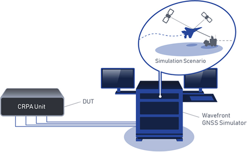
Wavefront simulator
Added to software-defined platform
Photo: Skydel Solutions
The BroadSim Wavefront Simulator is a new addition to Skydel’s software-defined platform. The BroadSim Wavefront further extends the capabilities achieved by BroadSim Anechoic, incorporating support for controlled radiation pattern antenna (CRPA) and multi-element receiver testing. Powered by Skydel SDX, the simulator’s features include phase-coherent simulation, real-time automated phase calibration, scalability from 4 to 16 elements, and advanced jamming and spoofing scenarios. Talen-X, www.talen-x.com
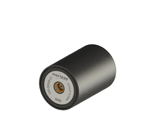
GNSS antenna
For high-precision and autonomous applications
Photo: Maxtena
The M7HCT-A-SMA is a high-accuracy, multi-frequency active quadrifilar helix GNSS antenna designed for high-precision and autonomous multi-frequency applications. The design offers concurrent GNSS reception on L1 (GPS, GLONASS, Galileo, Beidou) and L2 (GPS L2C, Galileo E5B and GLONASS L3OC) in a rugged, compact and ultra lightweight form factor. The antenna is designed for GIS, RTK and other high-accuracy GNSS applications such as the drone and automotive markets. Helicore technology provides exceptional pattern control, polarization purity and high efficiency in a 25-gram form factor. The antenna offers up to 30-dB gain for GNSS applications in one radome housing with a single SMA connector. Maxtena, maxtena.com
Portable simulation
Solution for field-test requirements
Photo: CAST Navigation
The CAST-1000 duplicates GPS RF signals and uses dual-frequency signal generation technology. This allows for duplicate testing in the laboratory or the field and real-time or configured control. The CAST-1000 is mobile and portable, which makes it the ideal solution for field test requirements. Producing GPS and GLONASS signals with up to 12 satellites in view, the CAST-1000 simulates signals for satellites of P code on L1 and L2 and C/A code on L1. The GPS RF signal is dual-frequency and has a 12-channel configuration for any combination of visible space vehicles. The system is highly programmable — operators can choose from an array of vehicle types and replicate dynamic motion for all kinds of vehicles, from terrestrial to aquatic, airborne to space-based. By utilizing 6-DOF dynamic profile data collected in the field and through profile configuration, a trajectory can be created. The CAST-1000 also features a performance evaluation module, allowing for comparisons between raw and filtered data. CAST Navigation, www.castnav.com
Survey & Mapping
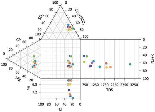
Graphing software
New plotting features
Photo: Golden Software
Version 14 of the Grapher scientific graphing package offers new plotting and customizing functionality based on user feedback. The Grapher software gives users deeper insights into their data by providing them with 80 flexible and easy-to-use 2D and 3D graphing tools for plotting, analyzing and displaying scientific data sets. The package is used extensively by scientists and engineers in oil & gas operations, hydrologic/geochemical studies, environmental consulting, mineral exploration and academic research. New or upgraded features include Enhanced Plotting (the ability to plot data in rows and columns, perform one-button Durov class plots, and easily generate multi-plot reports); and Improved Bar Charts (bar charts are more versatile, offering variable bar widths and differentiated fill colors for negative and positive). Golden Software, www.goldensoftware.com
GIS software update
New lidar functionality
Photo: Blue Marble Geographics
Global Mapper version 20.1 offers new and updated geospatial tools, as well as performance improvements throughout the application. Enhancements to version 20.1 include a new zooming function in the path profile window, a digitizer tool for automatically closing gaps between features and, for lidar module users, a point proximity query function. Blue Marble Geographics, www.bluemarblegeo.com
Survey application
For the geospatial industry
Photo: Global GNSS
The GNSS Surveyor mobile application provides location information and quality position data in real time with sub-meter to centimeter accuracy. It connects to any external GNSS receiver via Bluetooth. Features include a one-touch configured command to communicate directly with the GNSS Bluetooth device; location information and quality of the position data in real time with centimeter accuracy; GPS data such as position, height, satellites and velocity; and constellation information for GPS, GLONASS, Galileo, BeiDou, QZSS and SBAS satellites. It also includes a direct IP feature for real-time kinematic (RTK) corrections data. An internal NTRIP client loads RTCM data from the internet. Location information is collected as latitude and longitude, altitude, speed or pace, bearing and UTC time. GNSS precision includes global coverage, centimeter-level accuracy, fast time to first fix, multi-constellation and multi-band, and highest security. Navigation uses include ground robotics navigation, lane-level navigation, heavy machine navigation, industrial navigation and tracking, and commercial UAV. Global GNSS, globalgnss.com
Indoor mapping
Slam technology removes point cloud artifacts
Photo: NavVis
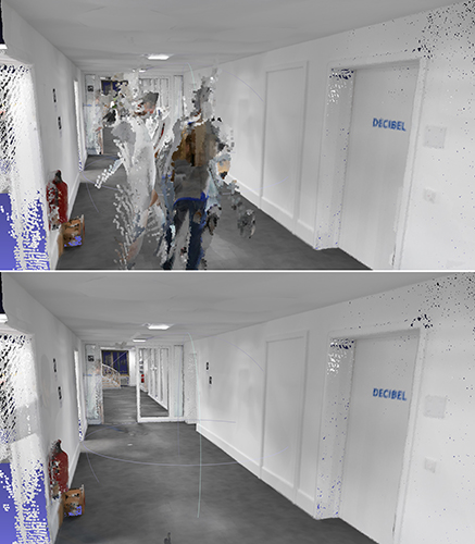
The SLAM-based NavVis M6 Indoor Mobile Mapping System (IMMS) now automatically detects and removes point cloud artifacts, including moving objects in static scenes. The latest IMMS release removes artifacts from point clouds during the post-processing of scan data (see before and after image above). Fringe points and dynamic objects are two common types of point cloud artifacts that affect all 3D laser scanning devices. The NavVis M6 IMMS uses laser scanners to capture a high volume of measurement points of an environment. With the latest software update, the algorithms applied during the post-processing of scan data uses the multiple observations to detect whether measurement points actually exist in the physical space. If it is determined that the point does not exist and is instead resulting from the laser beam hitting an edge or an object moving through the space, this point is automatically removed. The result is a much cleaner, crisper point cloud that requires less clean-up time in point-cloud editing software and that is easier to use for applications such as BIM modeling. NavVis, www.navvis.com
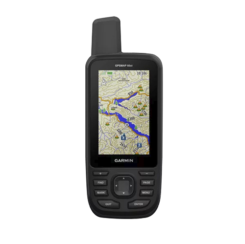
Mobile & UAV
Adventure handhelds
Larger display, improved access to Satellite imagery
Photo: Garmin
Garmin has updated two premium adventure-oriented handhelds, the GPSMAP 66s and the GPSMAP 66st, with expanded wireless connectivity, direct-to-device access to BirdsEye satellite imagery, weather forecasting and a larger 3-inch sunlight-readable color display. The GPSMAP 66st offers preloaded topographic maps for U.S. and Canada, with detail of coastlines, rivers, summits, terrain contours and geographical points. Connectivity to the new Garmin Explore app and the BirdsEye Satellite Imagery (no annual subscription) bring high-resolution photo-realistic route views. Weather updates come via Bluetooth to a compatible mobile device. The Explore app includes features for outdoor navigation, trip planning, mapping and data sharing. Features include multi-GNSS satellite support and altimeter, barometer and compass sensor capabilities; 16 hours of battery life in full GPS mode; LED flashlight and SOS beacon; built to military standards for thermal, shock and water performance (MIL-STD-810G); RINEX data logging that enables sub-meter accuracy of GPS position after post processing. Garmin, garmin.com
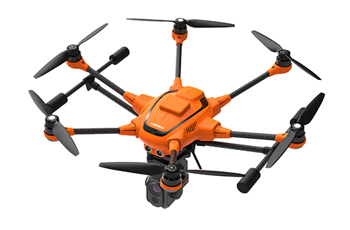
RTK Hexacopter
Integrated GNSS improves accuracy
Photo: Yuneec International
The H520 hexacopter is now available with a real-time kinematic (RTK) system. The fully integrated RTK satellite navigation enables extremely accurate recurring images and faster 3D mapping. It also makes automated inspection flights easier and more precise. The H520 RTK is suitable for commercial applications that require maximum precision. By using RTK technology, the H520 can now fly much closer to objects for inspection because the UAV positions itself precisely in the centimeter range (1 cm + ppm horizontal / 1.5 cm + ppm vertical) rather than in the meter range, which is standard for the H520. Yuneec International, us.yuneec.com
Web-based data service
Enables sharing of UAV data sets
MAGNET Collage Web is a web-based service enabling the sharing and collaboration of UAV and scanning data sets. Version 1.3 allows operators to work with more types of data with greater flexibility, including the ability to import BIM models, as well as CAD and GIS data. It can be used to overlay as-built laser scans and design data to visualize proposed changes and detect construction issues. The software supports OBJ, FBX and 3DS formats. The upgrade also includes new direct publishing functionality for CAD and GIS data files through the browser. Topcon, topconpositioning.com
Administered by the National Geospatial-Intelligence Agency (NGA), the mission of IGAPP is to streamline the deployment of commercial mobile apps to government personnel by bridging the gap between traditional government contracting procedures and non-traditional businesses.
Blue Marble’s GIS software is used by hundreds of thousands of mapping professionals throughout the world who need affordable, user-friendly, yet powerful GIS solutions. Users come from a wide range of industries including software, oil and gas, mining, civil engineering, surveying and technology companies, as well as government departments and academic institutions.
Available on both iOS and Android platforms, Global Mapper Mobile enables remote access to mission-critical geospatial datasets in an easy-to-use application. Used in conjunction with the desktop version of the software, Global Mapper Mobile supports hundreds of GIS data formats — both raster and vector — and offers simple, form-based field data collection and geotagged photo capture.
To address the specific needs of the geospatial intelligence (GEOINT) community, the IGAPP version of Global Mapper Mobile includes streaming access to online data services and the ability to store downloaded tiles for remote offline use.
“IGAPP provides mission-relevant, cyber secure mobile apps to warfighters, aviators, mariners and first-responders,” according to John Holcomb, IGAPP program manager at Engility, the NGS’s broker for putting commercial applications into the GEOINT App Store. “The program provides commercial vendors with a rapid, cost effective, path to sell their products. We are thrilled to add the Global Mapper Mobile the store and look forward to getting into the hands of DoD users.”
“Over the years, the GEOINT community has strongly supported our products and has provided valuable feedback that has helped ensure the functionality of our software is addressing the needs of geo-intelligence,” stated Patrick Cunningham, Blue Marble President. “We are delighted that Global Mapper Mobile is now available through IGAPP and that more and more field personnel now have easy access to this valuable app.”
Global Mapper v.20.1 offers a new zoom tool in the path profile view. (Photo: Blue Marble Geographics)
Blue Marble Geographics has released Global Mapper v.20.1, the latest version of its GIS software. According to the company, version 20.1 offers a wealth of new and updated geospatial tools, as well as performance improvements throughout the application.
Enhancements to version 20.1 include a new zooming function in the path profile window, a digitizer tool for automatically closing gaps between features and, for lidar module users, a point proximity query function.
Global Mapper’s path profile tool, which is used to create a cutaway view of a terrain layer or point cloud, now offers a simple way to zoom in the view for a close-in perspective of a specific area, the company said. It also now includes a new legend display that differentiates each individual layer when multiple overlapping surfaces are displayed.
The software’s digitizer now includes a simple tool for eliminating slivers or overlapping areas from adjacent features, ensuring the topological integrity of the data. In addition, users can now use an added option that allows the establishment of a default projection, with every imported layer automatically reprojected to adhere to this system.
Finally, version 20.1 release offers new and upgraded functionality in the lidar module. The module now features a proximity search function that highlights points of a particular classification within a certain distance of other point types or line features.
“The release of version 20.1 of Global Mapper provides a perfect illustration of Blue Marble’s unique, user-focused development philosophy,” said Blue Marble’s President Patrick Cunningham. “Each of the major new features and functions, including the new Path Profile tools and lidar proximity querying, is directly attributable to specific requests from our customers. We encourage all Global Mapper users to continue this line of communication to ensure that the software is meeting everyone’s needs.”
Blue Marble Geographics has launched its 2019 Geographic Calculator, which features a universal copy and paste function, a new angular unit conversion tool, support for NADCON 5.0 and updated seismic survey conversion functionality.
According to Blue Marble, the foundation of the Geographic Calculator’s geodetic data processing functionality is the embedded GeoCalc datasource, which is continually revised and improved with updates through the online GeoCalc Geodetic Registry. The datasource included in the 2019 release mirrors the most current EPSG database definitions.
The calculator’s copy and paste function can be used to quickly capture data for use in a third-party application or to insert new coordinate values in an existing job. The latest version also includes a new tool for accurately converting between various angular units and offers expanded seismic survey conversion capability with improved P1/11 format support and additional SEG-Y format handling for coordinate scalar values, the company added.
The 2019 Geographic Calculator also includes support for NADCON 5.0 from the National Geodetic Survey, providing 3D coordinate transformations within the National Spatial Reference System, as well as several new projection methods.
The calculator also boasts a refreshed interface with new icons and graphic elements for various jobs and tools, as well as optimized architecture for the Windows 10 environment.
“With the imminent approach of the North American Terrestrial Reference Frame in 2022 the need for highly accurate geodetic tools has become more important than ever,” said Patrick Cunningham, president at Blue Marble. “Geographic Calculator continues to lead the way in this field and as is evident in release of the 2019 edition, we are continually raising the bar by providing ever more powerful tools combined with the world’s most expansive geodetic database.”
Blue Marble Geographics is a mapping software company based in Hallowell, Maine. The company offers a number of GIS software solutions, including data conversion, software development kits, low cost GIS, educational resources, 3D analysis, coordinate transformation and GPS.
Version 20 of the Global Mapper Software Development Kit (SDK) is now available, along with the accompanying Lidar Module SDK. Mirroring the most important capabilities of the desktop version of the software, the powerful developer’s toolkit provides software engineers with the means to embed the latest geospatial technology into their custom applications, according to software maker Blue Marble Geographics.
An elevation contour image in Global Mapper SDK. (Screenshot: Blue Marble)
Among the highlights of the version 20 release are dramatically improved vector data performance in both the 2D and 3D environments, updated 3D mesh rendering with colors now displayed in the 2D view, and faster display and export of online tiled datasets, the company said.
For more than 25 years, Blue Marble’s affordable, user-friendly GIS software has been meeting the needs of users in industries including software, oil and gas, mining, civil engineering, surveying and technology companies, as well as government departments and academic institutions.
The Global Mapper GIS application can display, convert and analyze virtually any type of geospatial data. The Global Mapper SDK and Lidar Module SDK provide software developers with a toolkit for accessing much of this functionality from within an existing or custom-built application.
The SDK also enables the creation of custom toolbars and extensions to enhance the data processing and analysis functionality of the standard version of Global Mapper. This capability allows in-house developers to create a unique version of the application to meet their specific needs or for software companies to build custom products for commercial distribution.
The functional highlights of the latest version of the SDK effectively illustrate the continued evolution of 3D GIS technology and Blue Marble’s commitment to providing a superior data processing engine for managing, visualizing and analyzing increasingly large 3D datasets. Such is the case with the improvements that have been made to the display performance of vector files with faster rendering in both 2D and 3D Views.
The display of 3D meshes or models, such as those created in Global Mapper’s Pixels-to-Points tool, has been improved with the photo-realistic colors now displayed in the top-down view. Online data processing has also seen improvements with significant speed increases when loading and exporting tiled data sources.
Additional upgrades to the SDK functionality include improved box resampling of color images, especially those with palettes; several new supported formats, including Cyclone PTX and Autodesk Recap (RCP and RCS) point clouds; new projections and datums, including GDA2020 (Australia) and TUREF (Turkey); and support for Intermap’s online NextMap worldwide elevation dataset.
For users of the Global Mapper Lidar Module, the version 20 SDK release also introduces a wealth of new and updated functionality. Point clouds can now be thinned, from both a 2D and 3D perspective, reducing file size and improving efficiency; a gridded layer can now be created from the classification values associated with lidar points; and a new scripting option has been added to apply colors to a point cloud from underlying imagery.
“The Global Mapper SDK has become one of the most important components of Blue Marble’s suite of geospatial products,” stated Patrick Cunningham, Blue Marble President. “Motivated by the rapid emergence of the desktop software as a major player in the GIS industry, developers are increasingly turning to the corresponding SDK to leverage the software’s powerful geoprocessing tools in a wide variety of third party applications. The improved data handling capability of the version 20 release demonstrates our commitment to providing tools that work efficiently with even the largest datasets.”
Blue Marble Geographics added NEXTMap worldwide elevation data — which includes Intermap’s newest generation of NEXTMap One — as an online streaming service within Global Mapper.
According to Blue Marble, NEXTMap One, developed by Intermap Technologies, offers both digital terrain model (DTM) and digital surface model (DSM) datasets at one-meter resolution for detailed analysis. With an active NEXTMap subscription, Global Mapper users can quickly and easily render these 3D datasets for an area of interest and make sure of the software’s extensive terrain and 3D analysis capabilities for contour generation, viewshed analysis, volume calculation and more, the company added.
The addition of NEXTMap elevation data as an online service complements Blue Marble’s 3D functionality. By offering immediate, on-demand access to the latest DSM and DTM datasets, geospatial professionals throughout the world can now efficiently conduct high-quality terrain analysis procedures without the need for locally collected data, Blue Marble said.
NEXTMap elevation data is available to Global Mapper users as a global dataset at one- to 10-meter spatial resolution. The DSM version contains both natural and man-made features, and the DTM is a clean bare earth model.
“Global Mapper users throughout the world often ask us about the availability of high-quality elevation data for their location and the inclusion of NEXTMap meets their needs perfectly,” said Patrick Cunningham, president at Blue Marble. “This data effectively expands the reach of Global Mapper by providing the opportunity for more and more uses to utilize the software’s 3D analysis functionality.”