Chronos Technology Ltd., a UK-based resilient synchronization and timing company, has transitioned to employee ownership through the Chronos Technology Employee Ownership Trust (EOT) Ltd.
Charles Curry who established Chronos Technology in September 1986 and was co-owner alongside his wife, Angela Curry, had been deliberating succession planning and their exit from the business. Various options such as a third-party sale or a management buyout were considered but quickly dismissed.
“I am aware of business owners who had exited through third-party sales and had not enjoyed the experience of working under new management for the agreed handover period,” Curry said. “New owners generally change the dynamic of the business, often introducing new staff and work practice without giving opportunity to existing staff and process, and we did not want this for Chronos.”
“Over the years we have established a work ethic that puts the customer first,” Curry continued. “The EOT protects the loyal Chronos family and ensures the customer-facing continuity of the business and, most importantly, safeguards jobs. Going forward, in the hands of the employees, the company will benefit from increased customer engagement and the commitment to a team approach to steer the business on the next phase of its journey.”
Chronos Technology specializes in resilient synchronization and timing systems, smart technologies, GNSS and cybersecurity solutions for critical national infrastructure, with industry experience gathered over 35 years in specialist technologies such as GNSS, PTP, NTP and SyncE.
The company provides GPS coverage solutions in hangars, manufacturing areas and underground, as well as smart technology solutions and GNSS jamming detection and location solutions for law enforcement. Customers include telecom, finance, energy, data centers, broadcast, aerospace, defence and security, enterprise/IT, emergency services, transport and manufacturing.
GNSS Underground Coverage for Tunnels, Stations, Car Parks, Bus Stations and Airports in the U.K.
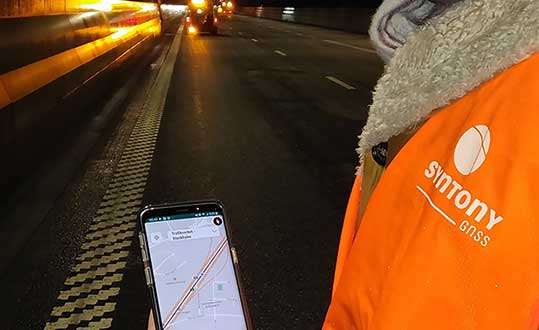
Syntony GNSS and Chronos Technology have formed a partnership to deliver underground GNSS positioning, navigation and timing (PNT) solutions for critical infrastructure applications in the United Kingdom.
Syntony GNSS is a leader and expert in the design and manufacture of GNSS systems, and Chronos Technology is a resilient GNSS system integrator.
GNSS coverage has become fundamental to many services from emergency services to asset tracking for example. Yet when entering an underground area such as a metro/subway, tunnel, car park, airport, or bus station for example, the GNSS signal is lost.
Syntony’s SubWAVE solution expands the GNSS coverage to underground areas, enabling the localization of any equipment with a standard GNSS chipset. Examples include standard smartphones and the TETRA Emergency Services Network handset used for security and services. Security and services applications include locating emergency calls, keeping track of staff, locating faults in tunnels, managing assets, locating trains and providing guidance.
A Syntony team member in a Swedish road tunnel during SubWAVE testing shows the positioning in an underground environment on a smartphone. (Photo: Syntony GNSS)
By emitting a perfect emulation of the “real” GNSS signal, SubWAVE offers underground operators, their staff, emergency services and the general public the benefit of full GNSS coverage in all underground areas for both operational and safety reasons.
One fundamental aspect is the user only needs a standard GNSS receiver (a smartphone or TETRA radio) — no new handsets, receivers or apps are required. The system operates by broadcasting synthetic location specific GNSS signals through existing or new leaky feeder cables in the tunnels.
Accuracy levels vary with leaky feeder and system complexity options; however, 2-meter accuracy is possible with a standard smartphone. The system is widely installed in the Stockholm metro and is in active trials throughout Europe and America.
“We are pleased to form a partnership with GNSS specialists Chronos,” said Joel Korsakissok, president of Syntony GNSS. “Their knowledge and experience, together with their dedicated installation, commissioning and support teams complement our sophisticated solutions.”
“Since its first general availability, one of the well-known shortcomings of the GPS system was lack of indoor or underground coverage,” said Charles Curry, managing director with Chronos. “Many have tried to solve this with various technologies over the years. Syntony’s innovative technology offers underground GNSS coverage for PNT applications. We are very excited by the possibilities and pleased to be partnering with them to offer their solution for critical infrastructure applications in the UK.”
In addition, Chronos will also supply Syntony’s sophisticated GNSS simulators used in the aerospace and defence industries for product testing.
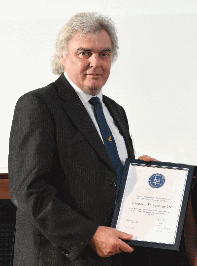
Charles Curry, founder of Chronos Technology, with the RIN award. (Photo: Chronos)
Chronos Technology has been recognized by the Royal Institute of Navigation (RIN) with its 2018 Duke of Edinburgh’s Navigation Award for Outstanding Technical Achievement in “recognition of technical excellence and authority in satellite navigation and timing vulnerabilities and mitigations.”
Charles Curry, founder and managing director of Chronos Technology, accepted the award at the RIN Annual General Meeting held June 10 in London.
Chronos has worked with the RIN and others since 2008 to raise awareness of GNSS vulnerabilities, and in collaboration with the University of Bath has developed a family of GNSS interference detection products.
Chronos first started researching this phenomenon with the University of Bath in the Innovate U.K. project GAARDIAN in 2008, closely followed by the SENTINEL and AJR projects. The projects have focused on detecting and locating commercial off-the-shelf jammers mostly sourced from Chinese websites.
The first success was seizing the so called “Girvan Jammer” in 2011, when a jammer was recovered from a commercial van driver through collaboration with the serious and organized crime group of the local police.
This exercise took about two weeks from initial detection to recovery of the jammer and should be compared to the six months it took U.S. enforcement agencies to identify the so called “Newark Jammer.”
SENTINEL sensors were originally rolled out in 2010 continue to provide real evidence of jamming at various locations around the U.K. The project assists police work by collating jamming events by day and time of day using a cloud-based portal.
The GPS interference detection portfolio includes low-cost, handheld GNSS interference detectors with features such as data logging and direction finding capabilities to precisely pinpoint a jammer.
The latest product to emerge is known as “JammerCam,” and is the first GPS jamming detector in the world to be able to take photographs of a moving vehicle, which is carrying a GPS jammer. This is now in trials with various local police forces and is photographing vehicles with jammers on a daily basis, providing real-time actionable intelligence to the law enforcement officers’ smartphones identifying vehicle type, color and number plate.
Early trials with this research are leading to the seizing of at least one jammer per week by U.K. law enforcement agencies.
Chronos has demonstrated the ability to work with universities and potential users to develop new, affordable products to meet a genuine need. Customers include U.K. and international law enforcement agencies and military users.
“This is a very prestigious award, as a look at the previous winners will attest,” said John Pottle, director of the Royal Institute of Navigation. “Chronos is very well respected and has continued to innovate, achieving global influence from their U.K. base. Many congratulations to all at Chronos for this well-deserved recognition.”
Curry was awarded Fellowship of the Royal Institute of Navigation in 2016 in recognition of his significant and continuing contribution to the practical aspects of time measurement and dissemination, including research into GNSS vulnerabilities and the use of eLoran for precise time.
“Chronos is honored to be the recipient of the RIN’s 2018 Duke of Edinburgh’s Navigation Award for Outstanding Technical Achievement,” Curry said. “We could not have done this without our close association with the University of Bath, in particular Dr. Robert Watson and Professor Cathryn Mitchell and their colleagues in the Electrical & Electronic Faculty.
Over the years, this association has enabled Chronos to undertake research and bring to the market GPS jamming detection products which have been thoroughly field tested at locations such as Sennybridge in the Brecon Beacons, and other international jamming trials in Norway and the U.S.
“In particular, Chronos was the only British company to be invited to JamX17 in Idaho Falls, U.S., by the U.S. Department of Homeland Security to showcase the detectors’ technology,” Curry said.
Intelligent vehicles and smart devices could gain more accurate location awareness by fusing GNSS and Wi-Fi signals. A test for this is the focus of an Innovate UK project led by Spirent Communications and involving the Warwick Manufacturing Group (WMG) at the University of Warwick.
The £694k Enhanced Assured Location Simulator Leveraging Wi-Fi and GNSS Sensor Fusion (ELWAG) project will seek to develop and test the pioneering hybrid Wi-Fi and GNSS location system in a cost-effective, repeatable and safe environment so that manufacturers can verify its performance.
International Manufacturing Centre at WMG. (Photo: WMG)
Researchers at WMG, led by Matthew Higgins, will play a significant role in the project. They will take physical layer measurements of both Wi-Fi and GNSS signals in autonomous vehicle scenarios in and around the University of Warwick campus and the local urban road network.
The measurements will then assist in Spirent’s development of an RF propagation model that will overlay RF effects on its Wi-Fi Access Point simulator.
WMG researchers will then perform RF validation and verification activities around the developed model, to provide a level of assurance on its performance.
“The safety and functional assurance of future autonomous vehicles will be one of the many critical paths to large consumer adoption,” said Higgins, who is an associate professor in the intelligent vehicles group at WMG. “Through this project, we will contribute towards providing innovative solutions to the challenges of using sensor fusion in this testing context.”
“This is a highly technical project, which will require a holistic understanding of the signal propagation characteristics between satellites, infrastructure and vehicles. The results will impact future autonomous testing methodologies,” said Erik Kampert, senior research fellow at WMG.
The ELWAG project will run for 18 months, and also involves Chronos Technology.
Project background. Many devices currently rely on a singular location technology (typically GPS), which is one type of the wider eco system of GNSS. These systems, whilst becoming more capable, still suffer at times from the user’s environment — typically in urban areas where buildings and other cityscape features interfere with the signal.
The urban environment is, however, where most users need to know their location to the highest level of accuracy, due to increasing population or device density. Wi-Fi signals exist almost universally within dense urban areas, so there is a possibility of fusing these signals with the GNSS signals to identify one’s location very accurately.
“Currently Wi-Fi access point plus GNSS simulation can only be achieved in an ad hoc manner and does not allow for the testing of moving vehicles, multipath effects, insertion of data errors, spoofing and above all controlled, repeatable testing,” said Mark Holbrow, director of engineering and product development at Spirent’s positioning business unit.
“In the autonomous vehicle sector location accuracy can vary by up to 5 meters, which is unacceptable from a safety perspective. Bringing that accuracy down to 30 centimeters through sensor fusion will have substantial implications for autonomous navigation.”
Self-aware smart devices. The need for smart devices to have a highly accurate self-awareness of their own location, and the location of other smart devices around is becoming increasingly important.
In applications such as autonomous vehicles and transport systems, accurate location awareness is an obvious operational requirement for their safe operation in and around other vehicles, pedestrians or infrastructure.
In the personal devices space, smartwatches, phones and health monitoring and exercise aids are all striving to be able to make a judgment of the user’s state based upon location.
In the emergency and security services space, knowing the location of people and objects is also increasingly important as to target response capabilities effectively.
It happened in the blink of an eye. Less than a blink. Far less, actually. Slightly more than one one-thousandth of an eye blink, according to calculations. In that amount of time, one of your eyelashes traverses 10 micrometers on its journey toward your lower eyelid.
And yet it was long enough to throw computers and communications systems around the world out of whack, generate thousands of alarms, and pull engineers from their beds at 2 a.m.
One occurrence might have been enough to do all that. I’m not sure. But it kept happening over and over again. Thus the alarms, the out-of-whackness, the sleep deprivation. At least it did not generate massive financial trading sell-offs, blow holes in national security, or shut down Facebook, Instagram and Snapchat. For that, we may be thankful.
But it might have.
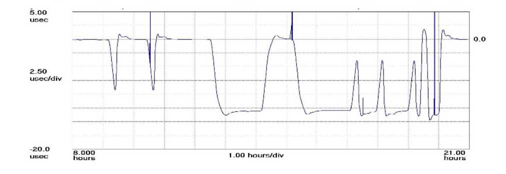
The plot shows how the anomaly event impacted one GPS timing receiver during the day. (Click to enlarge | Chart: Chronos Technology)
“On 26 January at 12:49 a.m. MST, the 2nd Space Operations Squadron at the 50th Space Wing, Schriever Air Force Base, Colo., verified users were experiencing GPS timing issues. Further investigation revealed an issue in the Global Positioning System ground software which only affected the time on legacy L-band signals. This change occurred when the oldest vehicle, SVN 23, was removed from the constellation. While the core navigation systems were working normally, the coordinated universal time timing signal was off by 13 microseconds which exceeded the design specifications. The issue was resolved at 6:10 a.m. MST, however global users may have experienced GPS timing issues for several hours.” (This excerpt from an U.S. Air Force communiqué appears in a brief news account.)
“The Joint Space Operations Center at Vandenberg AFB has not received any reports of issues with GPS-aided munitions, and has determined that the timing error is not attributable to any type of outside interference such as jamming or spoofing. Operator procedures were modified to preclude a repeat of this issue until the ground system software is corrected.”
Companies and their time-servers around the world were subsequently hit by up to 12 hours of system warnings after 15 GPS satellites broadcast the wrong time, according to Chronos, a UK-based time-monitoring firm.
Telecommunications companies constitute only a small part of industry users who rely on the highly precise accuracy of time measurements — supplied by GPS — to control data flow through their networks. Global financial networks and trading markets similarly depend on GPS, as do electrical power grids and many other sectors of critical national infrastructure. These companies and networks invest significantly in highly sophisticated equipment to monitor said timing accuracy as conveyed by GPS signals. Because billions, make that trillions — or actually even more — are riding on it.
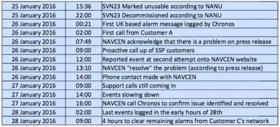
A week after the eye blinks, Chronos Technology released a white paper describing the ensuing fallout for its clients, who are timing equipment users in more than 50 countries around the world. Table 1 from the white paper reports the experience of a few during the event. One company registered nearly 2,500 alarms from its timing equipment during the outage.
Click to enlarge. (Table: Chronos Technology)
At one point during the crisis, according to the white paper, “it appeared that the GPS error had cleared and the Chronos SSP Manager was able to force the units out of holdover. However the scale of the problem escalated as these sites went back into holdover along with dozens of other sites suffering GPS-based timing issues. It was apparent at this point that there was something amiss with the GPS constellation itself.”
Later on, the report states, “This event linked to SVN23 has been one of the most significant service affecting issues for GPS timing users and sits alongside the April 1st 2014 GLONASS outage in scale — however its impact on global timing services is much more extreme.”
Ominously, “Chronos is aware of other more catastrophic impacts to networks and non-telecom applications which were not under supply and support contracts.”
As Loran Is Our Savior. At least one timing-reliant company was not disturbed by the problems, because it was testing an alternative timing service provided by enhanced Loran (eLoran) signals.
Unfortunately for them — and for the rest of us — eLoran has a very uncertain future. In fact, they were lucky to have an eLoran signal at all on January 26, because it was supposed to have been turned off on December 31. Somebody must have forgotten to tell the operators at the Anthorn giant antenna field in Cumbria to go home.
France, Norway, and the United Kingdom, three countries that had been keeping eLoran alive, officially abandoned the effort at the end of last year, reportedly because of lack of leadership from the United States.
The U.S. government decommissioned all its Loran stations a few years ago, even going to the extent of blowing some of them up (perhaps to prevent them from falling into the hands of subversives). Despite a recent reinvigorated interest in enhanced Loran technology, it may be too little, too late.
Whoa, Nellie. The first recorded use of the term “back-up technology” occurred in 1892, when farmers were urged not to prematurely abandon their mules in favor of John Froehlich’s new gasoline tractor.
Dan Albone on his prototype Ivel Agricultural motor. (Image: North Bedfordshire Gazette, 1903)
That admonition, however prudent, has since passed from view. But the concept remains sound. It has surfaced many, many times in GPS World magazine. Certainly not the first incidence, but the farthest back that I can retrieve via search on our website, came in 2007 from Defense contributing editor Don Jewell. “Why do we need a backup? Here is a classic case in point.” He describes a Joint Navigation Conference briefing on a surprise jamming incident that had occurred in January of that year.
In 2009, we reported on an Independent Assessment Team (IAT) report that “unanimously recommends that the U.S. government complete the eLoran upgrade and commit to eLoran as the national backup to GPS for 20 years.” The report was written in 2007, but quashed by the Department of Transportation and Department of Homeland Security (DHS) Executive Committees that commissioned it. Its public release came only after an extensive Freedom Of Information Act (FOIA) battle.
The U.S. government proceeded, despite its paid experts’ recommendations, to blow up those old Loran stations. The current renewed interest and the Wildwood experiment are worthy — more than worthy. Can they prevail? Can they survive blind reliance on a single string of vulnerable technology?
Indubitably, the critical role of GPS back-up was advanced prior to 2007, I just can’t document it this morning by deadline. For the sake of argument, let’s take April 12, 2007, as our start.
We are now 3,229 days out. That’s 77,496 hours, or nearly 279 million seconds. Correct me if wrong, but that appears to make 21.5 million-million times the length of January’s GPS timing error. Surely sufficient to blink a few times, scratch one’s head, and wonder.