ICAO Secretary-General Juan Carlos Salazar told delegates at the 2026 World Overflight Risk Conference in Vallarta, Malta, that emerging military technologies — including long-range weapons systems, unmanned aircraft systems (UAS), GNSS radio frequency interference, and advanced air defense systems — pose growing risks to civil aviation.
“We must now reach beyond the boundaries of aviation as we have known it,” Salazar said, adding that increasingly sophisticated weaponry is creating conditions in which civilian aircraft face a heightened risk of being targeted or caught in crossfire.
While praising the aviation industry’s ability to reroute flights and maintain operations during the recent Middle East crisis, Salazar said operational flexibility alone cannot address the underlying security threats posed by weapons systems.
He commended states and airspace users for measures taken to mitigate safety and security risks during the escalation in the Middle East, noting that more than 10 states partially or fully closed their airspace, significantly disrupting international air transport.
“This commitment to resilience, adaptation, safety and security is the foundation of our industry,” he said, calling for concrete steps to prevent civil aviation facilities, airports and aircraft from being targeted.
Salazar cited ICAO Assembly Resolution A42-4 and Article 3 bis of the Chicago Convention — which prohibit the use of weapons against civilian aircraft — as the legal basis for stronger protections. He said, however, that international law alone has proven insufficient as regional conflicts intensify.
Following ICAO guidance, Salazar urged states to take three immediate actions: rapidly share threat intelligence when activities pose risks to civilian aircraft; strengthen risk assessment and timely decision-making; and improve coordination between military and civilian authorities to prevent misidentification of civilian aircraft as military targets.
ICAO is finalizing a Global Crisis Management Framework to coordinate responses when civil aviation faces threats. Salazar said the reactive framework must be paired with proactive measures to prevent attacks.
The organization is also updating its Manual Concerning Safety Measures Relating to Military Activities and its Risk Assessment Manual for Civil Aircraft Operations Over or Near Conflict Zones, with a focus on improving how authorities, airlines and air navigation service providers assess threats from malicious activity.
Recent disruptions during the Middle East crisis demonstrated both the industry’s adaptability and the economic impact of operating in an increasingly militarized airspace environment. ICAO regional contingency frameworks have supported rerouting when airspace becomes unsafe, but officials said such measures are costly and temporary, not solutions to underlying security risks.
The two-day Malta conference, which opened April 21, brought together aviation officials and security experts from multiple regions to discuss implementation of safety protocols and information-sharing mechanisms. The Safer Skies initiative also serves as a framework for those discussions.
Salazar’s remarks mark one of ICAO’s most direct acknowledgments of growing risks to civil aviation arising from conflict zones, reflecting the organization’s core mission to maintain safe and secure international air travel amid rising geopolitical tensions.
Following the conference, Salazar met with Myriam Spiteri Debono to discuss global and regional developments affecting aviation, with a focus on the role of multilateral cooperation in addressing emerging challenges, including conflict-zone risks. He also commended Malta’s aviation sector.
Salazar was accompanied by Nicolas Rallo, director of ICAO’s European and North Atlantic Regional Office.
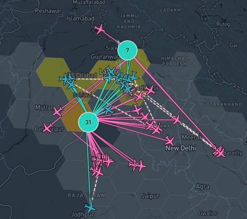
India’s Directorate General of Civil Aviation (DGCA) has issued an adendum on reporting procedures for suspected GNSS spoofing, reports news service AIN. On Nov. 10, the DGCA began requiring that all spoofing and jamming incidents be reported within 10 minutes, following an intense period of disruptions around Indira Gandhi International Airport in Delhi.
The addendum is meant to clarify exactly what pilots and operators are required to do both before and after a GNSS interference incident is suspected.
The disruptions produced false EGPWS alerts, position errors, and incorrect altitude indications, according to OpsGroup. The interference briefly drove ADS-B integrity in the Delhi terminal area to zero, affecting hundreds of aircraft and leaving controllers unable to rely on GPS-based surveillance.
The Qatar Civil Aviation Authority (QCAA) this week is hosting the Joint ICAO Europe and North Atlantic (EUR/NAT) and Middle East (MID) Workshop on GNSS Radio Frequency Interference, reports the Qatar News Agency.
The workshop is organized jointly by the ICAO EUR/NAT and MID Regional Offices and is being held in Doha, Qatar, Nov.18-20.
In the opening session, Mohamed bin Faleh Al Hajri, QCAA manager, reaffirmed Qatar’s commitment to enhancing aviation safety and efficiency through close collaboration with ICAO and regional partners.
The workshop brings together countries and stakeholders from the EUR/NAT and MID regions to address the increasing threat that GNSS radio frequency interference poses to aviation safety and efficiency. Al Hajri emphasized the importance of active participation to exchange experiences, strengthen cooperation, and build sustainable partnerships that support GNSS resilience.
He highlighted that hosting the workshop reflects joint efforts aimed at strengthening the robustness and reliability of GNSS — a core pillar in ensuring the safety and efficiency of international air navigation.
Regional dialogue
The workshop aims to:
facilitate regional dialogue on the operational impact of GNSS radio frequency interference
share experiences among participating States and stakeholders
explore measures to improve reporting mechanisms, enhance mitigation strategies, and strengthen the overall resilience of satellite-based navigation systems.
It also seeks to reinforce cooperation between the EUR/NAT and MID Regions to safeguard the infrastructure and integrity of GNSS-based navigation systems.
GNSS researchers presented hundreds of papers at the 2022 Institute of Navigation (ION) GNSS+ conference, which took place Sept. 19–23 in Denver, Colorado, and virtually. The following five papers focused on atmospheric effects on GNSS signals. The papers are available at www.ion.org/publications/browse.cfm.
Addressing Scintillation Error
Mitigating the scintillation effect at low latitude is a complex matter: several kinds of experimental data must be collected, realistic models must be developed, and, most importantly, useful real-time indices and alerts must be made available.
The authors introduce a prototype based on a patent owned by SpacEarth Technology to address scintillation error detection and mitigation, supporting precision GNSS-based services at low latitudes in any season and space weather conditions. The patent relates to a method of total electron content (TEC) and scintillation empirical forecasting, in particular short-term forecasting (seconds to minutes). The output of the method is necessary to feed mitigation algorithms aiming at improving accuracy on GNSS precise positioning techniques (RTK, NRTK, and PPP) under ionospheric harsh conditions.
The prototype is designed with a Central Elaborating Facility, which collects the data provided by a network of GNSS monitoring stations detecting scintillation events, and broadcasts foreseen scintillation parameters. Users with a rover mitigation device can apply the parameters from the central facility for scintillation error mitigation.
Vincenzo Romano, INGV and SpacEarth Technology; Claudio Cesaroni, INGV; Luca Spogli, Alessandro Fiorini, INGV and SpacEarth Technology; Marco Fermi, Gter; Lorenzo Benvenuto, Gter and University of Genoa; Tiziano Cosso, Gter; Marcin Grzesiak, SRC/PAS; Joao Francisco Galera Monico, Italo Tsuchiya, UNESP; Gabriel Oliveira, Marcos Guandalini; “Ionospheric Scintillation Mitigation at Low Latitude to Improve Navigation Quality.”
Ring of Fire GUARDIAN
Commonly, natural hazards release energy into the Earth’s atmosphere in the form of acoustic-gravity waves, which propagate up to the ionosphere. The resulting traveling ionospheric disturbances (TIDs) can be detected using GNSS signals, through the computation of the integrated total electron content (TEC) along the lines of sight between GNSS receivers and satellites. The global distribution of ground-based GNSS receivers constantly tracking multiple GNSS constellations (GPS, Galileo, GLONASS, BeiDou, and others) provides excellent spatio-temporal coverage around the world, including in areas of limited coverage by existing warning systems.
The authors present the operational GNSS-based Upper Atmospheric Real-time Disaster Information and Alert Network (GUARDIAN). Based on dual-frequency GNSS data from the Global Differential GPS (GDGPS) network of the Jet Propulsion Laboratory, the GUARDIAN architecture computes slant TEC time series in near real time.
As part of the GDGPS network, 78 stations around the Pacific ring of fire monitor the four GNSS constellations: GPS, Galileo, GLONASS and BeiDou. Cycle slips are corrected and the time series are filtered, both in real time. The resulting data stream is output live to a user-friendly public website, benefitting the general public and the scientific community.
The current GUARDIAN focuses on the Pacific region. However, the architecture can readily be extended to a worldwide coverage.
Léo Martire, S. Krishnamoorthy, L. J. Romans, B. Szilágyi, P. Vergados, A. W. Moore, A. Komjáthy, Y. E. Bar-Sever, A. B. Craddock, NASA Jet Propulsion Laboratory, California Institute of Technology; “GUARDIAN: A Near Real-Time Ionospheric Monitoring System for Natural Hazards Early Warnings.”
Civil Aviation Interference
The authors provide a survey on GNSS receiver architectures with emphasis on new carrier-tracking techniques for mitigating the adverse effect of ionospheric scintillation within the context of civil aviation. The survey is complemented by results gathered from simulations on the impact of ionospheric scintillation in conventional receiver architectures. A review on scintillation mitigation techniques is carried out, covering several “technique families,” highlighting their potential for performance improvement, as well as their shortcomings and challenges in implementation.
A semi-analytical simulation campaign is carried out for different modulations: L1, L5 for GPS, and E1, E5a for Galileo. Here, the performance of a standard receiver tracking a set of GPS and Galileo satellites affected by ionospheric scintillation is analyzed to pinpoint existing vulnerabilities to this effect.
The simulation results show that ionospheric scintillations are responsible for large variations in carrier-to-noise ratio, which in turn can be responsible for losses of lock and large phase variations, increasing phase RMSE and in some cases leading to cycle slips of the phase estimation. Thus, the adopted solution must be robust to signal power fluctuations and the occurrence of cycle slips and able to maintain phase lock.
António Negrinho, GMV-PT Pedro Boto, GMV-PT Marta Cueto, GMV-ES Mikael Mabilleau, EUSPA Claudia Paparini, EUSPA Ettore Canestri, EUSPA; “Survey on Signal Processing Techniques for GNSS Ionospheric Scintillation Mitigation.”
Tonga Eruption Data Analyzed
Extreme natural disasters, such as volcanic eruptions, can create visible pressure waves in the atmosphere and trigger observable ionospheric wave responses that can travel hundreds of kilometers in the ionosphere. The acoustic and gravity waves generated can cause ionospheric TEC perturbations and variations. The TEC determines the GNSS ionospheric delay and can cause significant positioning errors, which may affect the performance of GNSS-based applications.
The researchers processed GNSS data collected from the Hong Kong Satellite Positioning Reference Station Network to analyze the ionospheric activity and positioning performance responding to the Tonga volcanic eruption on Jan. 15, 2022. To detect and repair cycle-slip jumps, the researchers applied theTEC rate and Melbourne Wubbena Wide Lane (MWWL) linear combinations. A Savitzky-Golay low-pass filter with a 30s window was used to improve the TEC accuracy.
The team investigated the changes in TEC, Rate of TEC index (ROTI) and positioning errors in the eastward, northward and upward directions after the anomalous ionospheric propagation to Hong Kong between 11:30 and 14:30. The team found the ionospheric anomaly could generate large changes in the three parameters, with peaks up to three times the calm period. Their prompt research contributes to a better understanding of the coupling of extreme ionospheric activities and dynamics caused by volcanic eruptions.
Xiaojia Chang, Kai Guo, Zhipeng Wang, Kun Fang, Hongxia Wang, Beihang University; Hailong Chen, China Academy of Aerospace Electronics Technology; “Ionospheric Anomaly and GNSS Positioning Responses to the January 2022 Tonga Volcanic Eruption.”
Toolbox for Monitor Network
The MONITORtoolbox is a set of Python-coded software tools to perform automatized large-scale processing of data from the Monitor network of the European Space Agency (ESA). The Monitor network aims to continuously monitor ionospheric scintillation events from multiple ground stations strategically located around the globe. It accommodates a repository with a large number of GNSS measurements containing scintillation events for users to analyze scintillation data or for research purposes.
This paper shows the potential of the MONITORtoolbox for providing access to a large amount of data that otherwise, without a systematic processing, becomes practically useless. The software developed implements the means to collect data and store it in a local database for quick offline access. It detects the presence of scintillation events based on certain conditions and criteria defined by the user and identifies its properties in terms of duration, time of occurrence, intensity and satellite location. It implements the tools to compute relevant statistics, providing insights on ionospheric scintillation phenomena.
Sergi Locubiche-Serra, Alejandro Pérez-Conesa, Diego Fraile-Parra, Gonzalo Seco-Granados, José A. López-Salcedo, Universitat Autònoma de Barcelona, IEEC-CERES; Juan M. Parro-Jiménez, Raúl Orús-Pérez, ESTEC, European Space Agency; “MONITORtoolbox — Software Tool for the Analysis of Ionospheric Scintillation Data from the ESA Monitor Network.”
Project GENIE (GNSS Excluded Navigation Intelligent Enhancement) will mature and advance non-GNSS solutions as part of a long-term objective to enable assured location and navigation in commercial aerospace, helping to unlock the benefits and value of autonomy in civil aviation. The support from NATEP will enable the consortium to take a significant step toward navigation in GNSS-spoofed or -denied environments, the companies said.
“Tomorrow, as we look towards single-pilot operation and future autonomous aircraft, there will not be a pilot or air traffic controller available to mitigate these risks,” stated the companies in a press release. “GENIE has been developed to step into this role. It will be able to identify when a GPS signal has been compromised and, using a combination of techniques, provide a location position as accurate as GPS.”
“The need to provide assured, resilient navigation is a critical enabler for autonomy in the aerospace environment,” said Charles Smith, CCO at Archangel Imaging. “GENIE is a core element of this, and we are very excited to be working with NATEP to help push this technology forward. We see significant commercial exploitation opportunities as a result of this project in the UAV and broader aviation markets and are thrilled to be a part of this round of NATEP funding and support.”
Are military tests that jam and spoof GPS signals a threat to the safety of civil aviation? If not, why? If so, who should do what about it?
Bernard Gruber
“I would offer that military tests that jam and spoof signals are a risk. The U.S. military takes great care to control tests of this nature in an informed and careful way in order not to affect civil aviation. I cannot speak for military tests that are conducted by other countries. We all recognize the worldwide proliferation of small and large jammers that can negatively affect GPS performance and satellite-born transmissions. Accordingly, GPS users should remain vigilant to these potential hazards, including spoofing, and consider alternative navigation means where risks dictate.” — Bernard Gruber
What are the remaining obstacles to creating a seamless indoor/outdoor positioning and navigation system that integrates data from GNSS, inertial guidance, indoor positioning systems, and signals of opportunity?
John Fischer
“The primary use case for indoor navigation is the smartphone. We can create multi-sensor navigation systems today that operate indoors, but not at the very small size, weight, power, and cost targets needed for the personal phone market. IMUs and processors continue to improve over time, so there may be a breakthrough there, but signals of opportunity (SoOP) navigation is promising and offers resiliency through diversity. The most ubiquitous SoOP is cellular and with ultra-reliable low latency (URLL) features coming on-line for 5G in the next few releases, we may see reliable positioning from 5G in indoor environments very soon.” — John Fischer
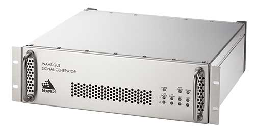
Next-generation NovAtel ground uplink station signal generators delivered for SBAS modernization
Photo: NovAtel
Hexagon/NovAtel announced that shipments of next-generation ground uplink station (GUS) signal generators have commenced in fulfillment of its contract with the United States Federal Aviation Administration (FAA) to support the FAA’s safety of life wide-area augmentation system (WAAS) navigation service.
Developed by the FAA for civil aviation, WAAS is a safety-critical navigation aid that provides integrity monitoring and differential corrections for all phases of flight. The next-generation NovAtel GUS signal generator replaces the legacy product that has operated successfully for more than 15 years and ensures continued operation for years to come.
Along with the GUS signal generator modernization, the contract includes ongoing engineering support services for the complete portfolio of NovAtel ground reference receiver products deployed by the FAA.
“We have a long-standing relationship with the FAA and worked very closely with the WAAS program team to deliver this critical next-generation technology for SBAS modernization,” stated Jonathan Auld, NovAtel Vice President of Engineering and Safety Critical Systems. “We’re very pleased to continue our commitment to support the FAA and their safety of life WAAS service.”
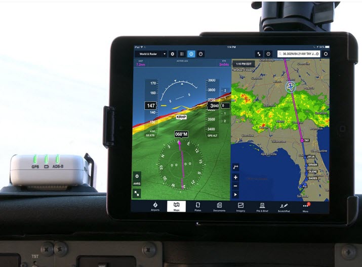
A cockpit equipped with ADS-B controls. (Photo: FAA)
Canada will be delaying the implementation dates for Phases 1 and 2 of its ADS-B Out Performance Requirements Mandate, according to a report by the Canadian Owners and Pilots Association.
ADS-B stands for Automatic Dependent Surveillance – Broadcast. Deadline for aircraft in the United States to be equipped with ADS-B Out capability is Jan. 1, 2020.
The original deadline for implementation in Canada was set for Feb. 25, 2021, for Phase 1-Class A airspace and Class E airspace above FL600, and Jan. 27, 2022 (Phase 2-Class B airspace).
Because numerous industry operators have stated they will not be able to meet those deadlines, new Phase 1 and 2 implementation dates will be set.
Transport Canada-Civil Aviation (TCCA) has also stated that some regulatory matters must be dealt with before implementation can take place.
There is no word yet on how this might affect the implementation of remaining phases — C, D and E), according to the report. Nav Canada’s performance requirements mandate document states that implementation of the different phases will be a minimum of one year apart.
ADS-B Out. ADS-B Out broadcasts information about an aircraft’s GPS location, altitude, ground speed and other data to ground stations and other aircraft once per second.
Air traffic controllers and aircraft equipped with ADS-B In can immediately receive this information.
Tbe ADS-B offers more precise tracking of aircraft compared to radar technology, which sweeps for position information every 5 to 12 seconds.
Analysis of Satellite Data Exposes Threats to Civil Aviation
The Russian Federation is growing and actively nurturing a comparative advantage in the targeted use and development of GNSS spoofing capabilities to achieve tactical and strategic objectives at home and abroad.
Cover: C4ADS
A new report titled “Above Us Only Stars: Exposing GPS Spoofing in Russia and Syria,” presents findings from a year-long investigation ending in November 2018 on an emerging subset of electronic warfare (EW) activity: the ability to mimic, or spoof, legitimate GNSS signals to manipulate PNT data.
Using publicly available data and commercial technologies, the authors detect and analyze patterns of GNSS spoofing in the Russian Federation, Crimea and Syria. They profile different use cases of current Russian state activity to trace the activity back to basing locations and systems in use.
The report is issued by C4ADS, a Washington, D.C.-based nonprofit organization dedicated to providing data-driven analysis and evidence-based reporting on global conflict and transnational security issues. Its website, c4ads.org,lists transnational organized crime, proliferation networks (rogue nations and non-state actors), threat finance and supply-chain security as areas of focus.
Pinpointing interference. Todd Humphreys, a University of Texas at Austin associate professor and head of the university’s Radionavigation Laboratory, collaborated on the research underpinning the report.
Humphreys stated that, as far as he knew, the study constitutes the first characterization of GNSS interference from space, and cited “some interesting findings:
“Using Automatic Identification System (AIS) data captured by overhead satellites, we monitored spoofing in the Black Sea, around St. Petersburg, Archangelsk, etc., and built a picture of interference activity that spans two years. All such activities occur near Russian coastal waters.
“Correlating this activity with the travel schedule of the Russian head of state, we have strong evidence that the spoofing is a protective measure used to thwart drone attacks on Vladimir Putin.
“By exploiting a software-defined GNSS receiver my lab is operating on the International Space Station, we were able to pinpoint a powerful source of interference, which we found to be coming from the northwest quadrant of a Russian-operated airbase in Syria. This explains the many reports of GNSS interference in the eastern Mediterranean during the past year.”
Global Threat. The tools and methodologies for perpetrating GNSS interference are proliferating at a rapid rate, and the frequency of such incidents around the world increases steadily. GNSS attacks, and GPS attacks specifically, now constitute an active, present, disruptive strategic threat in every theater of operation.
The C4ADS website, in announcing the report, states that “The Russian Federation has a comparative advantage in the targeted use and development of GNSS spoofing capabilities. However, the low cost, commercial availability and ease of deployment of these technologies will empower not only states, but also insurgents, terrorists and criminals in a wide range of destabilizing state-sponsored and non-state illicit networks. GNSS spoofing activities endanger everything from global navigational safety to civilian finance, logistics and communication systems.”
Examining GNSS spoofing events across the entire Russian Federation, its occupied territories and overseas military facilities, the report identifies 9,883 suspected instances across 10 locations that affected 1,311 civilian vessel navigation systems since February 2016. It demonstrates that these activities are much larger in scope, more diverse in geography, and longer in duration than any public reporting suggests to date.
C4ADS believes the Russian Federal Protective Service (FSO) operates mobile systems to support this activity. It chronicles the use of GPS spoofing in active Russian combat zones, particularly Syria, for airspace-denial purposes. This capability is scarcely reported in the public domain. C4ADS identified ongoing activity that poses significant threats to civilian airline GPS systems in the region.
The next generation of Europe’s satellite navigation overlay service, EGNOS, will combine use of GPS and Galileo signals to improve accuracy and robustness of navigation for air traffic and other uses where lives are at stake.
A contract was signed Jan. 26 at ESA’s technical centre in the Netherlands for the second generation of the European Geostationary Navigation Overlay Service, EGNOS V3, planned to enter service in 2025.
ESA Director of Navigation Paul Verhoef signs the EGNOS V3 contract Jan. 26 with Senior Vice President of Airbus Defence and Space, Mathilde Royer Germain. (Photo: ESA)
ESA Director of Navigation Paul Verhoef signed the contract with the senior vice president of Airbus Defence and Space, Mathilde Royer Germain, in the presence of senior managers of the European Global Navigation Satellite System Agency (GSA) and of the European Commission.
This improved version of the service will take advantage of in-operation Galileo signals as well as new frequencies from an improved class of GPS satellites. Use of the L5 second frequency will improve service robustness against errors and propagation delays caused by the ionosphere, an electrically active outer layer of Earth’s atmosphere.
“This will be the first such regional satellite augmentation systems worldwide to employ dual frequency, GPS and Galileo signals,” comments Didier Flament, overseeing EGNOS development for ESA.
For aircraft with the latest avionics, EGNOS V3 will be able to guide them accurately and safely down to Category 1, a 10 m Vertical Alert Limit (also called Cat1 Autoland capability), while also providing legacy users equipped with current avionics a more robust version of the current LPV200, or 35 m vertical limit vertical guidance service.
As well as improving services for civil aviation, the plan is to introduce new services for other sectors such as maritime navigation and rail, and extend service coverage from the European continent to link up seamlessly with other interoperable augmentation systems worldwide.
EGNOS is Europe’s other satellite navigation system, next to the global Galileo system. Comparable to the US WAAS, the Wide Area Augmentation System, and other regional augmentation systems in the rest of the world, EGNOS is an overlay system based on a network of ground stations and transponders on geostationary satellites. These stations gather data on the current accuracy of US GPS signals and embed correction data in the EGNOS signal, which is uplinked via geostationary satellites to EGNOS users.
The current EGNOS augments the accuracy of GPS signals across Europe and informs users of their current reliability level within six seconds. EGNOS belongs to a family of systems called Satellite Based Augmentation Systems (SBAS); the EGNOS V3 second generation will augment both GPS and Galileo.
Designed against global standards set by the International Civil Aviation Organisation, EGNOS began offering its Open Service for non-safety-of-life uses in October 2009. In March 2011 its Safety-of-Life Service became available for aircraft navigation.
Dozens of European airports are today employing EGNOS for vertical guidance approaches, as an economic alternative to ground-based infrastructure, like Instrument Landing Systems. It is estimated that that around 110 000 aircrafts worldwide are today equipped and using SBAS systems.
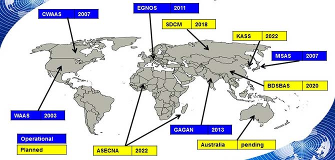
The development of satellite-based augmentation systems around the world is being coordinated in particular by the international SBAS Interoperability Working Group, which last week held its 33rd meeting at ESA’s centre in Madrid, chaired by ESA and the US Federal Avigation Authority, joined by current or planned service providers from Africa, Australia, Canada, China, India, Japan, Russia and South Korea.
Initiated by ESA in cooperation with the EU and Eurocontrol, the EGNOS Exploitation phase is managed by GSA and funded by the EU. ESA manages the EGNOS development under a working arrangement signed between GSA and ESA.
EGNOS V3 will offer improved and secure Civil Aviation Safety of Life services for the next decade over Europe. The program will ensure a full continuity of service and will be the first operational SBAS using both GPS and Galileo.
Airbus has been selected by the European Space Agency (ESA) as the prime contractor to develop EGNOS V3, the next generation of the European Satellite Based Augmentation System (SBAS) planned to provide the civil aviation community with advanced safety-of-life services and new services to maritime and land users.
Developed by ESA on behalf of the European Commission and the European GNSS Agency (GSA), EGNOS V3 (European Geostationary Navigation Overlay Service) will provide augmented operational safety-of-life services over Europe that improve the accuracy and availability of user positioning services from existing GNSS (Galileo and GPS).
EGNOS also provides crucial integrity messages to EGNOS users with alerts within a few seconds in case of system degradation, consolidating EGNOS’ position as one of the leading edge GNSS systems in the future.
Besides improved safety-of-life services, EGNOS V3 will improve robustness against increasing security risk, in particular cyber-security risks.
EGNOS V3 will ensure a full continuity of service for the next decade and will be the first operational SBAS implementing the dual-frequency and multi-constellation world standard, with both GPS and Galileo, replacing EGNOS V2 which has been in operation since 2011.
“This programme is strategic for Airbus to strengthen our position in the Navigation field. The signature of this contract is the result of more than 5 years of intense team work and investment,” said Nicolas Chamussy, head of Space Systems at Airbus. “With our consortium, we bring a large pool of resources and experience in Europe covering the successful development of critical and secure ground segment. I am confident that we will make EGNOS V3 a success story.”
As prime contractor, Airbus will be leading a consortium with partners from France, Germany, Spain and Switzerland. Airbus will be responsible for the development, integration, deployment and preparation of EGNOS V3 operations, the overall performance of the system and the Central Processing Facility, which is the heart of the real-time navigation algorithms.
During the 6.5-year contract, around 100 people and 20 subcontractors will work on delivering the EGNOS V3 system. In 2023, the single-frequency version will be available to replace the current operational version and, 18 months later, the final version in dual frequency will be delivered.
EGNOS is composed of a large network of about 50 ground stations deployed over Europe, Africa and North America, two master control centers near Rome and Madrid, and a System Operation Support Centre in Toulouse. EGNOS will also use geostationary satellite navigation payloads.
Spirent Communications plc is offering a solution that enables the civil aviation industry to evaluate the growing threat of GNSS interference, jamming and spoofing.
The new GSS200D Interference Detector was developed as part of Spirent’s partnership with Nottingham Scientific Limited.
Spirent’s GSS200D interference detector.
As skies and airports become more congested, there is increasing pressure on airports to be safely accessible at all times — which cannot be achieved by relying solely on non-precision approaches with high minimums or on today’s expensive and rigid ground-based infrastructure such as ILS (Instrument Landing Systems).
Ground-Based Augmentation System (GBAS) and instrument approach procedures based on Satellite Based Augmentation Systems (SBAS), such as Localizer Performance with Vertical Guidance (LPV) and Required Navigation Performance (RNP), provide Air Traffic Management with flexible, cost-effective alternatives while providing equivalent operational performance.
For example, the European Geostationary Navigation Overlay Service (EGNOS) launched the LPV-200 service in Europe that enables aircraft approaches without the need for visual contact with the ground until a height of only 200ft. above the runway.
With this service, accessibility, sustainability, efficiency and safety of the landing are greatly improved, especially in bad weather conditions.
Spirent’s new GSS200D solution monitors the radio bands used by EGNOS, as well as other GNSS augmentation systems such as the Wide Area Augmentation System (WAAS) or the GPS Aided Geo Augmented Navigation system (GAGAN), to ensure awareness of interference that could compromise positioning information.
Since local interference near the runway in the GNSS bands could degrade position accuracy or lead to a total loss of the navigation service, it is critical to continuously monitor and understand the RF environment and level of interference around airports.
The GSS200D collects quantitative data on interference allowing assessment of the risks, so that robust mitigation plans can be created. The new Spirent solution has been trialed at a number of European airports, and has collected numerous interference signatures from both unintentional man-made interference and intentional jamming.
“As more airports begin to use GNSS-based instrument approach procedures, they need to know what could be affecting their GNSS signals,” said Martin Foulger, general manager of Spirent’s positioning business. “With this latest solution we can detect interference in the key radio bands, based on levels defined by the United Nations International Civil Aviation Organization and European Organisation for Civil Aviation Equipment. This enables the aviation industry to gain a much better understanding of the electronic environment, helping to avoid dangerous situations going forward.”
For more information on Spirent’s GNSS testing solutions, visit the website. To learn how to test receivers of GPS, Galileo and other GNSS, download Spirent’s latest eBook.