Rx Networks TruePoint.io global precise point positioning (PPP) correction service now provides quad-constellation support.
More mobile devices are integrating multi-constellation GNSS chipsets for better positioning. With quad-constellation expanded multi-constellation support, Rx Networks TruePoint.io global precise point positioning (PPP) correction service unlocks that accuracy, providing global PPP corrections for every major GNSS constellation those chips can track.
TruePoint.io global PPP originally delivered GPS and GLONASS corrections. Now, it also provides corrections for Galileo and BeiDou. Mass-market multi-constellation GNSS chipsets can now augment all their satellite measurements with accuracy and fully leverage their positioning capabilities with quad-constellation support.
Consumer devices now have the potential to achieve 50-cm position accuracy when using Rx Networks services for any of the four GNSS constellations. Other internet of things (IoT) and infrastructure applications that do not require real-time positioning can realize 10-cm accuracy in a variety of environments.
Multi-constellation correction capability ushers in new possibilities and use cases for the connected receiver, according to Rx Networks.
TruePoint.io remains ubiquitous and as flexible as possible to GNSS chipsets using industry standard formats, and is also receptive to custom integration services for unique usage scenarios. By offering PPP and other high accuracy services in a variety of data standards, TruePoint.io empowers telecom providers with a straightforward approach to integrating high- accuracy services that provide more value to their client devices, and propels the development of exciting new use cases.
“With this new expansion of TruePoint.io, applications already serviced by Rx Networks can accelerate their market growth objectives with better accuracy and precision using constellations ideal for target regions,” said Vincent Chen, product manager of Truepoint.io. “Being able to deliver global PPP corrections for GPS, GLONASS, Galileo and BeiDou also sets the stage for the addition of more constellations like QZSS. Stay tuned.”
MediaTek’s Dimensity 700 5G smartphone chipset is a system on chip (SoC) designed to bring advanced 5G capabilities and experiences to the mass market.
The Dimensity 700 joins MediaTek’s Dimensity family of 5G chips, which is designed to give device makers a suite of options for 5G smartphone models. The chips range from flagship and premium to mid-range and mass market devices to make 5G more accessible for consumers everywhere.
GNSS signals received include GPS L1CA and L5, BeiDou B1I and B2, GLONASS L1OF, Galileo E1 and E5, QZSS L1C and L5, and NavIC.
“With our expanded Dimensity portfolio, we’re bringing the latest 5G capabilities to every smartphone tier so more people can enjoy 5G experiences,” said JC Hsu, corporate vice president and general manager of MediaTek’s Wireless Communications business unit. “The Dimensity 700 has an impressive mix of 5G connectivity features, advanced camera capabilities like night-shot enhancements, and multiple voice assistant support, all in a super power-efficient design.”
Advanced connectivity features include 5G carrier aggregation (2CC 5G-CA) and 5G dual-SIM dual-standby (DSDS), giving users access to the fastest speeds and 5G-exclusive Voice over New Radio (VoNR) services from either connection, the company said.
On the processing power side, the chip integrates two Arm Cortex-A76 big cores in its octa-core CPU and operates at up to 2.2GHz.
MediaTek’s Dimensity 5G family of chips are designed for 5G devices across all tiers, and with the Dimensity 700 5G devices will now be accessible to even more consumers.
For full specifications and further details on MediaTek’s Dimensity 700 series and 5G portfolio are on the MediaTek website.
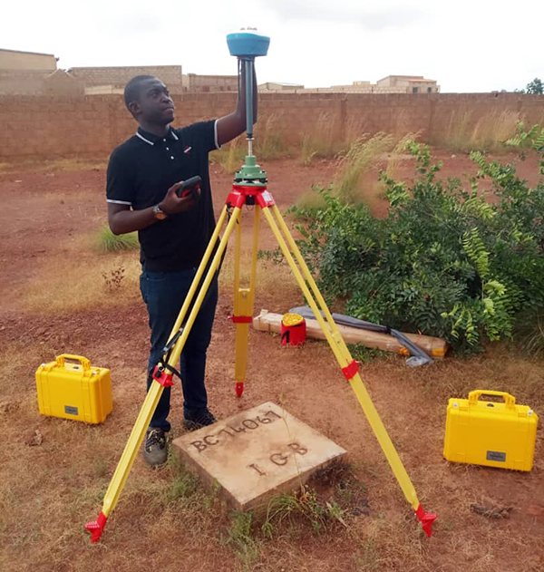
M10 receiver platform can track four GNSS constellations, even in challenging environments
Photo: u-blox
U-blox’s new M10 GNSS platform is designed for ultra-low-power high-performance positioning applications such as sport watches and asset trackers.
The M10 positioning platform can track up to four GNSS constellations at once to deliver positioning data even in challenging environments such as deep urban canyons. The receiver’s Super-S technology helps distinguish positioning signals from background noise to capture positioning data even when satellite signals are weak.
Its high RF sensitivity also enables it to work well with small antennas, making it suitable for compact product designs. In sport watches, for instance, u-blox M10 guarantees highly dynamic positioning accuracy during a run in cities, woods or under an open sky, while preserving battery life.
Low power consumption. The u-blox M10 is designed to consume 12mW in continuous tracking mode, five times less than the power consumed by previous u-blox meter-level GNSS technology, making it beneficial for battery-powered applications.
U-blox M10’s enhanced RF sensitivity also cuts the time it takes for the platform to achieve a first position fix when initialized, further reducing systemic power consumption. And switching to the improved Super-E mode can extend battery life even more.
This new GNSS platform will be supported by AssistNow, u-blox’s assisted GNSS service, to accelerate positioning and improve accuracy. Depending on the required level of assistance, the service is available free of charge or for a recurring fee.
Jamming detection. The u-blox M10 platform benefits from u-blox’s experience in building robust GNSS receivers, incorporating proven techniques for detecting spoofed signals through the analysis of raw GNSS data, jamming-detection strategies, and embedded filters to mitigate the effects of in-band RF interference.
“U-blox can be proud of over 20 years of experience with GNSS technology, and with u-blox M10 we are setting a new benchmark in ultra-low power high performance positioning applications,” said Bernd Heidtmann, product manager, Product Center Positioning, u-blox. “We have increased concurrent reception of satellite signals by a GNSS platform from three to four constellations and improved the power consumption level five-fold compared to previous generations while shrinking the chip size by 35 percent.”
Garmin International Inc., a unit of Garmin Ltd., has chosen SiTime’s micro-electromechanical system (MEMS) timing solutions for several of Garmin’s automotive, aviation, marine, fitness and outdoor products.
“Garmin makes products that are engineered on the inside for life on the outside,” said Patrick Desbois, Garmin executive vice president of operations. “Our innovation focuses on developing technologies that enable our customers to enrich their experiences as they pursue their passions. SiTime’s MEMS timing solutions help extend battery life across several of our product lines.”
SiTime timing solutions are the heartbeat of customers’ electronic systems. With the deployment of 5G, internet of things (IoT) and automotive electronics in challenging outdoor environments, manufacturers will need timing solutions that enable environmental robustness and solve difficult challenges, such as power, size, and reliability. With the proliferation of electronic devices, the timing market is expected to grow to $10.1 billion by 2024.
“Garmin creates products for active people,” said Piyush Sevalia, executive vice president of marketing at SiTime. “Precise time is at the heart of every GPS receiver and impacts the speed of signal acquisition as well as position accuracy.
“Garmin’s outdoor products encounter many environmental stresses such as shock, vibration, rapid temperature changes and extreme temperatures. SiTime’s MEMS timing solutions are engineered to provide the highest level of robustness to such stressors and provide a powerful value-add to Garmin’s high-performing, robust and reliable products.”
Quectel Wireless Solutions is collaborating with Microsoft and Qualcomm Technologies to integrate its new LPWA module BG95 with Microsoft’s Azure Device SDK.
The integration will provide direct and secure connections to Azure IoT Hub and provide full support for Azure device management capabilities.
Targeting global markets, the BG95 module is a cost-optimized, highly-integrated variant supporting integrated GNSS, Cat M1, Cat NB2 and EGPRS (also called EDGE). The module complies with 3GPP Release 14 and delivers improved capabilities in power consumption, data rates and hardware-based security.
The BG95 cellular module is based on the Qualcomm 9205 LTE modem, to be integrated with Microsoft’s Azure Device software development kit (SDK). As a result, customers can connect their BG95 devices to the Microsoft Azure cloud where they can build, manage and deploy internet of things (IoT) solutions at scale, significantly accelerating time to market.
By integrating RAM/flash, an ARM Cortex A7 processor supporting ThreadX, the BG95 is engineered to reduce power consumption significantly in idle mode.
By doing this, the BG95 has the potential to support decade-plus battery life, which is critical for IoT devices serving long life spans, such as asset trackers, smart meters, smart city sensors, home security and wearable trackers.
Additionally, Azure IoT is built for security. It simplifies the complexity of IoT security solutions with built-in protection at each stage of deployment (including cloud services and devices) and minimizes security weaknesses wherever they exist. Leveraging Azure IoT security features, Quectel BG95 will offer IoT devices end-to-end security capability in order to prevent potential risks.
“We’re excited for the Azure edge device ecosystem to continue to grow. Our partnership with Quectel and Qualcomm Technologies will deliver what our customers need — bringing together ultra-low power cellular modules and Azure to drive their digital transformation,” said Roanne Sones, corporate vice president at Microsoft.
“The BG95 module is the first Qualcomm 9205 platform to support IoT Plug and Play, accelerating LPWAN solution deployments like smart meters and asset trackers that connect seamlessly to our IoT Central offering,” Sones said.
“With its cutting-edge performance and power-saving capabilities, the Qualcomm 9205 LTE Modem is the gold standard for multimode IoT modules looking to offer NB-IoT, Cat-M1, GPRS, and GNSS connectivity,” said Jeffery Torrance, vice president, business development, Qualcomm Technologies, Inc. “We are proud to continue our long-standing collaboration with Quectel to jointly drive the IoT forward.”
“We are happy that the BG95-M3 has been verified on Microsoft Azure IoT Plug and Play. This validates our ability to jumpstart customers’ IoT projects with pre-tested modules and operating system combinations. Leveraging our close relationship with Microsoft and Qualcomm Technologies, we will jointly provide more integral ‘Device-Cloud’ solutions to customers,” said Doron Zhang, Chief Operation Officer, Quectel. “As one of the first wave Azure IoT PnP partners, Quectel has worked with Microsoft on LTE Mobile Broadband (MBB) modules, which have been widely adopted by top laptop OEMs. In the future, we will extend the partnership to more fields, such as Artificial Intelligence (AI) and Intelligent Edge, in order to help the Microsoft partner ecosystem connect their devices even more intelligently.”
In the second part of our receiver feature, top receiver manufacturers discuss what’s on the horizon for GNSS receivers: recent and upcoming innovations, combating spoofing and jamming, fusing GNSS with other sensors, and the impact of increasing accuracy both for professional surveyors and consumers.
In January, we featured responses from NovAtel, Trimble, Unicore, Topcon, Hemisphere GNSS, CNC Navigation and Septentrio to questions about their recent and upcoming innovations in the design and manufacturing of GNSS receivers. We continue in this issue with responses to the same questions from Javad GNSS, Swift Navigation, Eos Positioning Systems, Tersus GNSS, TeleOrbit, Allystar Technology and NTLab.
All GNSS receiver manufacturers agree that spoofing and intentional and unintentional jamming are serious challenges. Their approaches to dealing with these challenges differ, however, as they rely on different combinations of technologies on both their receivers (such as monitoring cycle slips and using analog-to-digital converters, correlators and notch filters) and their antennas (such as using array antennas), as well as the new Galileo authentication service.
Photo: Tersus GNSS
Many receiver manufacturers now routinely use optical, inertial and other sensors — which continue to drop in price and increase in performance — to supplement GNSS signals where they are degraded or denied, especially in the automotive market.
Carrier phase positioning and correction services are increasingly improving the accuracy of survey stations and reducing their price. Meanwhile, submeter accuracy is spreading beyond surveying to other industries. Performance in challenging conditions also continues to improve, thanks largely to the increase in the number of GNSS constellations, available satellites and frequencies. (For a review of recent developments in antennas, see our companion article here.)
On the consumer side, the introduction of multi-frequency GNSS receiver chips, the increased use of correction services, and, in a few countries, the deployment of thousands of additional base stations will continue to increase the location accuracy of cell phones and other consumer devices, enabling new applications. However, in these devices size and cost limitations make antenna performance particularly challenging. (See Part 1 here.)
Javad GNSS
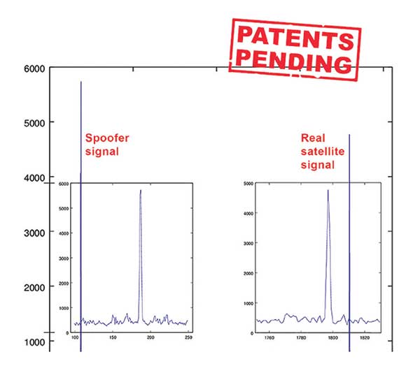
Jamming and Spoofing. “We protect you against jammers and spoofers like no one else can,” said Javad Ashjaee, founder and CEO of Javad GNSS. “We use multiple techniques to detect spoofers, the most important being the use of digital signal processing to detect more than one peak. First, with 864 channels and about 130,000 Quick Acquisition Channels in our Triumph chip, we have resources to assign more than one channel to each satellite to find all signals that are transmitted with that GNSS PRN code. If we detect more than one reasonable and consistent correlation peak for any PRN code, we know that we are being spoofed and can then identify the spoofer signals and ignore the wrong peak.”
An example of two peaks. (Chart: Javad GNSS)
Ashjaee described additional techniques:
The J-Shield filter blocks out-of-band interference.
Sixteen 255th-order FIR anti-jam digital filters protect against static in-band interference, and 16 adaptive 80th-order digital filters protect against dynamic interference.
Javad products measure the level of interference as a percentage of in-band noise above normal.
The Triumph chip has a powerful spectrum analyzer. Each spectrum shows the power and the shape of the interfering signals and jammers. This is more powerful and more efficient than using a commercial spectrum analyzer to evaluate the environment.
The chip also keeps a record of Automatic Gain Control, which is another indicator of external signals. A change in AGC can indicate interference.
Deviation of SNR from the expected value is another important indicator of interference.
“Usually there are over 100 signals available at any given time, and we need only four good signals to compute position. It is extremely unlikely that we can be spoofed without our knowledge.” Ashjaee concluded. “We will immediately recognize and take corrective actions.”
Jamming and spoofing protection is available on all Javad GNSS receivers and OEM boards. Read more about Javad GNSS’s jamming and spoofing protection in the December 2019 issue.
Sensor Fusion. “To support users in environments where GNSS RTK solutions are difficult or impossible to obtain,” Ashjaee said, “Javad GNSS has invented the J-Mate, which is a remotely controlled robotic EDM device and digital camera. GNSS RTK and optical can be seamlessly integrated using the J-Mate as the seventh RTK engine. Just set up a Triumph-3 on top of a J-Mate and a Triumph LS on top of a zebra rod, making the former pair the RTK base station and the latter pair the RTK rover.” Read more about Javad GNSS’s RTK and Optical United solution in the November 2019 issue.
Swift Navigation
Jamming and Spoofing. “Receivers have become more robust to intentional jamming by mimicking the jammers’ behavior to cancel it,” said Alex Pun, staff product manager for Swift. “Nevertheless, advanced jamming and spoofing mitigation often imply array antennas. A real evolution lies in considering these threats only in terms of the availability of the GNSS sensor, now part of a complete multi-sensor positioning engine such as Starling.”
Sensor Fusion. IMUs, visual sensors and GNSS will aid each other in different types of environments and scenarios, explained Pun. “Sensors are becoming more affordable, and their performance increases with each new generation. Sensor fusion will be the glue that will bind them to provide a precise positioning solution.”
Surveying. The combined use of carrier-phase positioning and correction services, such as Swift’s Skylark, will greatly improve accuracy and reduce the cost of survey stations, because they make their accuracy less dependent on the intrinsic performance of the receiver and the antenna, Pun said. “A global service eliminates the need for an individual base station.”
Consumer Devices. “The introduction of dual-frequency GNSS receivers from chip manufacturers will help improve positioning in cell phones and other consumer devices,” Pun said. “These chips, coupled with a widely available correction service such as Skylark, will greatly improve their performance accuracy to sub-meter levels.”
Other Challenges. Performance stability of the antenna and its characterization will become the main challenge to exploiting the new GNSS ASICs (application-specific integrated circuits) and correction services at their highest level of performance, Pun said. “A positioning engine can exploit this information to accelerate the convergence to the high-accuracy solution, and then improve its availability.”
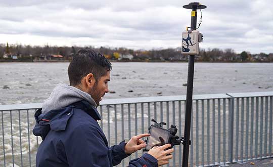
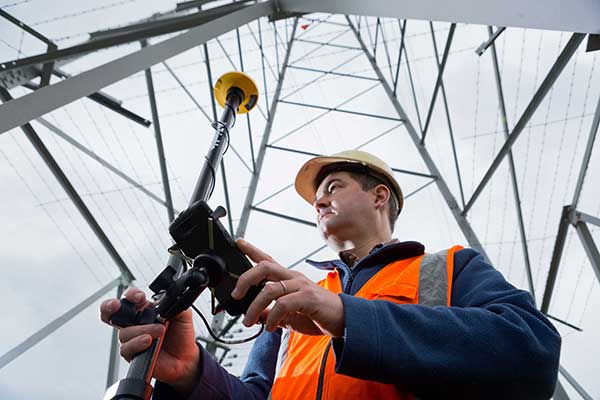
Eos Positioning Systems
A surveyor uses the Arrow Gold receiver to map assets in Terrebonne, Quebec, Canada. (Photo: Eos Positioning)
“The past three years have seen considerable innovations and trends in the GNSS industry,” said Jean-Yves Lauture, CTO of Eos Positioning. “Receivers are becoming increasingly affordable and the adoption of higher-accuracy (submeter, centimeter) positioning by other industries, outside of conventional surveying, is growing. Considering the now four usable GNSS constellations and the aggressive launches of Galileo and BeiDou satellites, the number of available satellites and the list of frequencies they use has considerably increased.
“Although accuracy itself is not really improving, performance is — particularly in tougher conditions. It’s not uncommon for customers to use 30 to 35 satellites out of more than 40 in view using an Arrow Series GNSS receiver. The numbers are even higher in the Pacific regions, thanks to geostationary BeiDou satellites. This is, by far, more than double the number of satellites available with just GPS and GLONASS.”
Consumer Devices. “It will be challenging for smartphones and consumer devices to achieve survey-grade accuracy in the next few years. They face certain limitations. For instance, there is a cost and physical size associated with using a high-end GNSS antenna with a minimum of ground plane to achieve these levels of accuracy.
The Arrow Gold RTK GNSS receiver. (Photo: Eos Positioning)
“Also, it is unlikely that the manufacturers of consumer devices will invest in developing the advanced algorithms needed for a high level of constant accuracy and performance. In order to fit into a smartphone, consumer-grade GNSS chipset manufacturers must drop the use of many available signals and frequencies to keep both size and power consumption to a minimum.”
Allystar Technology
Photo: Allystar
Jamming and Spoofing. The GNSS chip in Allystar’s TAU1301 module supports eight adaptive notch filters to reduce the effects of GNSS jamming, explained Shi-Xian Yang, senior principal engineer in the company’s Baseband Algorithm Department. “It significantly improves the performance of GNSS tracking measurements, even in the presence of strong and fast-varying jamming signals.”
Sensor Fusion. The TAU1310 integrates a six-axis micro-electromechanical system (MEMS) gyro, which makes its affordable for the mass market, Yang said.
The Lenovo Z6. (Photo: Lenovo)
Consumer Devices. In its Z6 smartphone, Lenovo has taken advantage of the great improvement in multipath mitigation provided by the L5 signal’s higher chip rate and the output of high quality raw data via the TAU1302’s HD8040 GNSS chipset to improve the accuracy experience in the consumer market, Yang explained. Additionally, he pointed out, cell phones and other consumer devices now enable developers to access the raw sensor data from such sensors as accelerometers and barometers to input into their fusion algorithms.
Other Challenges. In the future, the TAU1310 could also support the L6 signal for PPP-RTK application.
NTLab
NTLab anti-jamming GNSS receiver. (Photo: NTLab)
Jamming and Spoofing. The problem of jamming and spoofing worries customers, according to Konstantin Yuriev, lead GNSS engineer at NTLab. The combination of anti-jam and anti-spoofing is in greater demand because the anti-jam feature alone is becoming insufficient. Yuriev cited the European Union’s new requirements for the European Railway Traffic Management System (ERTMS), which makes anti-spoofing mandatory.
The key issue today is “the solution to the problem of reducing the size and cost of anti-jam receivers, so that they become available to consumers on the civilian market. The key technology for this will be increasing the degree of integration of the component base, first creating a chipset for solving anti-jamming and anti-spoofing tasks, and then moving on to a single-chip solution. We have created a chipset and are ready to start work on the further integration into a single chip.”
Sensor Fusion. The traditional task of integrating data from a GPS antenna and a MEMS sensor has been solved, Yuriev said, with many such solutions on the market. One task is to track the antenna’s tilt. “The antenna, GNSS receiver, and MEMS sensors should be located very closely to each other — if possible, on a single small board,” Yuriev said. “Here, again, the solution is to increase the degree of integration, up to placing the baseband processor on the same chip with the digital CMOS circuitry of the MEMS sensor.” Another application of MEMS is serving as the core of an inertial navigation system (INS), providing an auxiliary subsystem for detecting the presence of spoofing. “This is more of an algorithmic task,” Yuriev said, “because traditional coupling using recursive filters is not enough. It is necessary to ensure the independence of the INS subsystem from the GNSS solution, or their intelligent mutual cross-control.”
Surveying. A major part of the cost of a survey-grade device, Yuriev pointed out, is for additional services, know-how, and other added values. There is market demand for a business model in which device price could go down while maintaining the main values for the customer. “This could be achieved if end-users tightly cooperate with hardware manufacturers, skipping third-party integrators. Alternatively, multiple third parties could compete, keeping the cost of the software low. One of the technical solutions for this is to provide software application programming interfaces (APIs) that will allow multiple third parties to offer application-level software for the same hardware. We call it the ‘open platform’ approach. One of our products implements this strategy.”
Other Challenges. Despite some skeptics, Yuriev argued, new GNSS systems have been successful. “A good example is IRNSS (NavIC), with India’s population of 1.3 billion forming a potential market. Moreover, according to our studies, good coverage is provided not only in India’s territory. We are working on creating an economically affordable solution with support for the NavIC S-band. A new chip-scale packaged RFIC (radio-frequency integrated circuit) should minimize the size, consumption, and price of NavIC-oriented modules, while maintaining all the advantages of the S-band signal in areas close to the equator. This is our solution to the problem.”
TeleOrbit
GOOSE platform. (Photo: Fraunhofer IIS)
GNSS Receiver Development Platform. The company’s GOOSE platform is a field-programmable gate array (FPGA)-based GNSS receiver, developed by Fraunhofer IIS, making it flexible in processing new or proprietary signals, according to Katrin Dietmayer, software development engineer at Fraunhofer IIS. “It comprises 60 hardware channels in real time and provides an open software interface for customer applications,” she explained.
Jamming and Spoofing. “It grants deep access to the hardware interface, down to, for example, the correlation values. Additionally, anti-jamming functions (such as notch-filter or pulse-blanker) can be added and anti-spoofing algorithms are already implemented. Thanks to the open architecture, our customers can also implement these or other algorithms.”
Sensor Fusion. Vector tracking in real time is already implemented on code base. Deep coupling with INS/IMU multi-sensor fusion — for example, with an odometer, ultra wideband or 5G — are possible and under development, Dietmayer said.
Surveying.TeleOrbit provides GNSS-RTK using RTKLIB. “The implemented Open GNSS Receiver Protocol (OGRP) is fully documented with a parsing tool using CONVBIN from RTKLIB as RINEX converter,” Dietmayer explained.
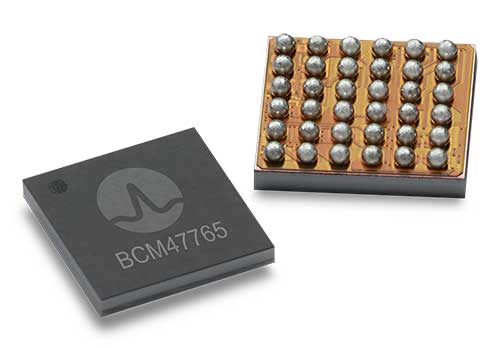
Consumer Devices. GOOSE is also used as the reference receiver in the ESA project Receiver Technologies for Future Mass Market (RT4FMM) devices. The project validates state-of-the-art dual-frequency mass-market receivers based on Broadcom BCM47755 and u-blox F9 and compares their performance against GOOSE E5AltBOC processing.
Other Challenges. GOOSE already processes the new Galileo OS-NMA (Open Service – Navigation Messages Authentication), while implementing the new Galileo High Accuracy Service (HAS) is on the roadmap. “The combination of these new features will result in a robust and reliable high-accuracy position,” Dietmayer said. “For system testing, the intermediate frequency signals can be recorded, processed and replayed with the platform.”
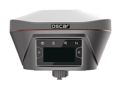
Tersus GNSS
The Oscar. (Photo: Tersus GNSS)
Jamming and Spoofing. Xiaohua Wen, founder and CEO, said his company has done much research and testing on jamming and spoofing. “We already implemented a high dynamic analog-to-digital converter to overcome jamming. To mitigate spoofing, we think that internet of things (IoT) devices can leverage cloud services. Alternatively, the new Galileo authentication service may serve the same function.”
Sensor Fusion.Tersus GNSS makes an INS product, and its Oscar receiver contains an inertial measurement unit (IMU). “The sensor fusion hub is a very hot topic in the automobile industry,” Wen said. “We are quickly adapting our Oscar and INS product line for the creation of high definition maps and for indoor navigation. We think it’s still the major pain point for a crowded country such as China.”
Surveying. As has been the case in many other industries, Wen said, the widespread adoption of GNSS technology and the increase in the number of players in the field has led to a drop in prices. “Tersus’ David and Oscar models are low cost but still perform well compared with Tier 1 players for professional survey machines using our own OEM GNSS board,” he said.
Consumer Devices. The fact that a few vendors are providing dual-frequency chipsets in smartphones opens the door for consumer-grade sub-decimeter applications, Wen said. “But we think the antenna could be a big challenge for the small devices.”
Other Challenges. “Mobile carriers are building thousands of base stations,” Wen said. “For example, Softbank in Japan completed 3,300 stations this year. China Mobile just issued a bid for a phase one project for 4,400 stations. We think mobile phone innovations for the new high-accuracy application may have some impacts in the coming years. We have been actively looking at some new GIS (geographic information systems) applications based on our in-house Nuwa platform.”
Top receiver manufacturers discuss what’s on the horizon for GNSS receivers. The companies reveal recent and upcoming innovations, how to combat spoofing and jamming, fusing GNSS with other sensors, and the impact of increasing accuracy both for professional surveyors and consumers.
With regard to jamming and spoofing, the preferred approach is a combination of monitoring, detection and filtering. However, shielding, the use of IMUs and other third-party sensors, and advances in processing algorithms also help mitigate interference. In a few years, hopefully, encrypted or “watermarked” signals will substantially reduce this problem.
IMUs and other sensors are now routinely integrated with GNSS receivers, with their outputs fused. This trend is largely propelled on the demand side by the needs of the emerging market for autonomous vehicles and on the supply side by smaller, cheaper and more accurate IMUs and lidar scanners. Meanwhile, developments in algorithms have improved the modeling of errors to correct for the inherent tendency of IMUs to drift. Additionally, digital cameras, lidar and other industry-specific sensors are increasingly common, especially for collision avoidance in human-machine interactions.
In surveying, the use of all constellations and frequencies, as they become available, is an industry trend. Costs will continue to drop as the growth in the adoption of GNSS solutions enables manufacturers to take greater advantage of economies of scale. Precise point positioning (PPP), which benefits greatly from the growth in GNSS constellations, is now giving real-time kinematic (RTK) positioning a run for its money. Available applications enable Android mobile devices to achieve centimeter accuracy, while innovations continue in core positioning algorithms.
In the world of mobile consumer devices, dual-frequency, multi-constellation GNSS chipsets are increasingly prevalent. As increased accuracy fuels expectations for even higher accuracy, precision positioning may become the norm in the consumer space, and new applications for these devices may emerge. Already, crowdsourcing the monitoring of both GNSS signals and interference helps improve accuracy for everyone, in a positive feedback loop.
Other notable trends include the introduction and expansion of 5G data networks, the increased use of satellite-based correction services, and continued efforts to develop precise positioning for indoor areas. (See part 2 of this feature here.)
Topcon
Jamming and Spoofing. “We continue to develop and deploy patented technology to detect spoofing,” said Alok Srivastava, director, product management. “We already have cutting edge GNSS antenna technology to provide stellar support for interference rejection and filtering.” All Topcon end products have this advanced antenna and filtering technology.
Sensor Fusion. “Topcon has been using inertial systems for decades for a variety of positioning applications — such as machine control, mobile mapping, and agriculture,” said Srivastava. “In recent years, advancements in IMU technology have progressed to where the size and cost of these sensors are at levels to be utilized at a larger scale. For example, the recently released Topcon HiPer VR takes advantage of inertial technology to improve productivity in real time with our Topcon Integrated Leveling Technology (TILT), which compensates for mis-leveled field measurements out of plumb by as much as 15 degrees.”
Surveying. Topcon continues to invest in its core positioning algorithms to innovate such features as quartz lock loop, advanced multi-engine platform, and VHD heading technology into its positioning engines, Srivastava said. “We also produce solutions such as our Millimeter GPS and Hybrid Positioning innovations, which are designed around improving accuracy, higher reliability, and greater flexibility by converging positioning technologies.”
Consumer Devices. “GNSS in consumer devices and other commercial systems is used to aid other positioning sensors,” Srivastava said. “So, it may not be in the best of interest to offer that level of accuracy from GNSS alone.”
Other Challenges. Precise indoor positioning is a requirement of the vertical construction industry. “Topcon’s combined optical instrument takes a unique approach to solve that problem by integrating a compact laser scanner with a fully featured robotic total station,” Srivastava said.
Photo: CHC Navigation
CHC Navigation
Jamming and Spoofing.CHCNav is currently taking a twofold approach to GNSS interference, said François Martin, vice general manager, International Division. “As a GNSS system integrator, we focus our design around strong electromagnetic shielding and sealed isolation chambers.” Additionally, he pointed out, the advanced filtering of GNSS signals and an antenna patch produce optimal interference mitigation.
Sensor Fusion. Integrating interference-free, high-dynamic IMUs instead of MEMS has brought the full benefits of tilt compensation to users, Martin said. The latest development in algorithms dramatically obviated the need for the annoying process of initializing GNSS IMU receivers and boosted the availability of GNSS RTK in demanding environments.
Surveying. The fast adoption of GNSS solutions by large user segments has reduced costs by enabling a sizable manufacturing economy of scale, Martin pointed out. “Tighter combination of embedded technologies such as GNSS and connectivity modules are sustaining that cost reduction process.”
Consumer Devices. “The emergence of dual frequency multi-constellation GNSS chipsets supports the development of untapped user segments, but the position accuracy repeatability remains an issue,” Martin said. “The integration of GNSS chipset and high-performance helical antennas, as precision add-on modules, onto rugged Android cell phone and tablets is creating a prosumer-grade centimeter to decimeter accuracy answering to a wide range of mobile workforce applications.”
Other Challenges. A growing number of positioning and navigation applications require the fusion of technologies to increase productivity, Martin said. “The integration of advanced tightly integrated positioning algorithms, scanners, IMUs, HDR cameras, IoT and cloud-based connected solutions are a clear trend.” However, their adoption by a large user base remains limited by their current price point.
Photo: Septentrio
Septentrio
Jamming and Spoofing. “Recent developments in receiver-antenna combinations maximize the benefits of anti-jamming techniques,” said Gustavo Lopez, market access manager. Third party sensors, such as IMUs, also help mitigate interference, he pointed out. “Septentrio’s advanced receiver technology such as AIM+, a standard feature on all the company’s products, bring not only real time monitoring but also jamming/spoofing mitigation. Galileo and GPS have clear roadmaps bringing signal authentication in order to avoid spoofing.”
Sensor Fusion. Smaller IMUs with higher grade performance now on the market are enabling new use cases in autonomous applications, said Lopez. Other important elements are a new generation of compact high-performance sensors and the growing importance of multi-sensor technology “to provide even higher levels of positioning integrity.” He cited Septentrio’s AsteRx-i family of products as an example of GNSS/INS integrated solutions.
Surveying. As an example of Septentrio’s survey-specific products, which “continuously benefit from advanced developments being rolled out in our platform,” Lopez cited the Altus NR3.
Consumer Devices. The increasing positioning accuracy of cell phones, Lopez pointed out, “has spurred innovations such as PPP and the use of mobile phone measurements,” as well as “other purposes, such as interference detection and crowdsourcing.”
Other Challenges. “Sensor fusion is a key element in positioning and orientation,” Lopez said. “Easy integration is a key element in this trend. Also, integrity in error reporting and positioning will be required as well as reliable raw measurements which can be integrated with other sensors. This drives the requirement for receivers capable of running customer proprietary software. Another important element will also be the possibility of running positioning algorithms on a third-party processor.”
Photo: Hemisphere GNSS
Hemisphere GNSS
Jamming and Spoofing. “Hemisphere’s new Lyra II ASIC platform used in our Phantom and Vega series positioning and heading boards,” said Miles Ware, director of marketing, “introduces new technology and filtering methods to identify and mitigate known and unknown interference sources that typically have an adverse effect on GNSS performance.”
Sensor Fusion. “Advancements in IMU integration and sensor fusion,” Ware said, “will continue to be a key focus for Hemisphere to support the growth and adoption of the expanding autonomous vehicle and application marketplace. The positioning and heading technology offered in our Vega 28 will be a core component for autonomous marine, machine control, and agriculture solutions for new and emerging markets.”
Surveying. “Access to modern and future signals like BeiDou Phase III, ALTBOC and BS-ACEBOC significantly enhance GNSS accuracy, especially in challenging environments where satellite visibility is compromised by the topography and or the structures present,” Ware pointed out. “Survey solutions that can not only track but also use all the available GNSS measurements in their RTK solution will have a substantial advantage in the market.”
Consumer Devices. “As mobile phones and consumer devices continue to adopt hardware designs that can access the latest GNSS signals,” Ware said, “the opportunities for solutions where high precision measurement engines can be hosted within mobile devices opens up a new realm of solutions that can leverage the high accuracy positioning performance found in Hemisphere technology and products. We see this as a very exciting and emerging area.”
Other Challenges. Ware pointed to “leveraging GNSS technology to further support environmentally friendly transportation solutions and sustainable agriculture,” for which GNSS continues to be an integral component.
Photo: Unicore
Unicore Communications
Sensor Fusion. “We are implementing GNSS with different level IMUs, including low-cost and high-end, targeting automotive, intelligent driving, and robot application scenarios,” said Gao Jingbo, marketing director. “The algorithm can also integrate with the already-existing sensors on the platform, such as IMUs, cameras and odometers. The solution can be done on the GNSS side, with high information synchronization accuracy, or processed on the platform.”
Surveying. Products with Unicore boards inside can provide centimeter- to millimeter-level positioning accuracy, said Jingbo. “Unicore’s high-precision boards and modules can track all frequencies of all satellite systems. The UGypsophila RTK technology can make the most of the observation data of all frequencies in all systems even without the observations of the base station in the RTK solution, thus greatly improving the usability, reliability and accuracy of RTK.” The company is now also working to reduce the dimensions and cost of its products, Jingbo pointed out. “With Unicore’s single GNSS SoC on board, the UB4B0M and UM4B0 modules are making affordable high-end high precision surveying possible.”
Consumer Devices. Algorithms and hardware are ready now to implement PPP+RTK in cell phones, Jingbo said, and this increase in positioning accuracy will enable many more applications. “We have rich experience in high precision GNSS, but the antenna might be a challenge. Our new generation 22 nm GNSS SoC features low power consumption and support of sensor fusion. Additionally, true point technology by Rx-Networks (also a BDStar company) can provide sub-meter data service, which also enables users to access centimeter-level accuracy location data through their mobile phones and wearable technologies, without increasing the demand for processing power.”
Photo: Trimble
Trimble
Jamming and Spoofing. “Trimble’s latest GNSS receivers leverage our seventh-generation Maxwell technology, which implements hardware- and software-based techniques to detect and mitigate spoofing,” said Stuart Riley, vice president, GNSS Technology. “In addition, Trimble continues to improve the robustness of our GNSS receivers with advances in processing algorithms and hardware enhancements such as the integration of inertial technology.”
Sensor Fusion. “For many years, IMUs have been widely used in Trimble agriculture and Applanix products,” Riley said. “Over the past few years, we’ve created a new line of lower-cost inertially integrated board-level GNSS receivers. We have also integrated inertial components into survey and construction products, including tilt compensation in the Trimble R10, R12 and SPS986 receivers. Trimble also combines its GNSS solutions with optical, laser, lidar and other sensors.”
Surveying. Trimble’s GNSS products, Riley pointed out, range from GIS handhelds to high-performance mobile mapping systems.
Consumer Devices. “The Trimble Catalyst system uses Android-based smartphones or tablets to run an application that includes a software-defined GNSS receiver,” Riley said. “The recently introduced SiteVision system builds on this ecosystem and integrates Google’s ARCore platform with precision GNSS to provide an augmented reality solution for a variety of professional applications.”
Other Challenges. To address signal masking and multipath, Trimble has “continued to improve performance in difficult environments with products such as the Trimble R12 receiver, which provides sophisticated multipath mitigation and an advanced precision processing engine.” Riley said, “Trimble’s RTX Correction Services, delivered via satellite, enable users to achieve RTK speed and accuracy nearly anywhere on the planet without the need for local reference stations.”
Photo: NovAtel
NovAtel
Jamming and Spoofing. “The RF environment is at best crowded and at worst hostile,” said Sandy Kennedy, vice president of innovation, Hexagon’s Positioning Intelligence division. “The NovAtel OEM7 generation of receivers was launched in 2016, with interference detection and mitigation as key features on every variant. Protecting authenticity, availability, and precision for multifrequency measurements is the challenge going forward — in all segments of the system: constellation management and SIS, antenna, receiver design and processing in FW/SW.”
Sensor Fusion. In the last three years, Kennedy pointed out, IMU manufacturers have made significant improvements in the performance offered in smaller, cheaper IMUs. “At the same time, new methods to improve error modelling (to control positioning errors) have been added to the NovAtel SPAN product line, especially in SPAN Land profile. Extended GNSS outages are easily handled now.”
Surveying. “PPP has become a strong competitor to RTK, as convergence times have decreased, and this will continue in service offerings like Terrastar-X from NovAtel,” Kennedy said.
Consumer Devices. The devices, Kennedy said, offer “the tantalizing promise of quality measurements from a common utility device with huge computing horsepower and data connectivity built in! It’s fun to watch, and we shall see if accuracy is truly addictive enough to fuel development for general use of precision positioning.”
Other Challenges. “In the past 20 years, users have moved from awe and wonder that centimeter-level positioning is possible — to utter contempt when it is not,” Kennedy said. “This will continue, with an added requirement of integrity and functional safety. Continuously available positioning within a usable protection level is a requirement for autonomous vehicles.”
BCM4776 chip utilizes 30 new L5 signals to deliver higher navigational accuracy and yield
Photo: Broadcom
Broadcom introduced in 2017 the first mass-market implementation of dual frequency: BCM4775. This chip makes use not only of the classic L1 frequency broadcast by every satellite, but also of the more advanced L5 signal broadcast by a subset of the satellites.
The use of this enhanced L5 signal improves the accuracy of GNSS in an urban scenario, as it mitigates the main source of error: the reflections in the nearby buildings, also known as multipath. It also improves GNSS in an open-sky scenario, allowing submeter accuracy, a previously unmet performance bar in smartphones until now. Ever since, the BCM4775 has been adopted in flagship smartphones, smartwatches and fitness devices.
Given the unabated need for better precision and accuracy, Broadcom has introduced its second-generation dual-frequency GNSS solution — the BCM4776.
The new chip is capable of using the new BeiDou-3 constellation’s B2a signals (the Chinese indicator for L5). It will be able to track 30 new L5 signals (60 percent more) with a significant impact on accuracy. End users will experience much higher reliability of the submeter accuracy inherent to dual-frequency L1-L5.
Image: Broadcom
Second generation dual-frequency GNSS will be used for innovative lane-level driving navigation instructions, allowing driving applications to know which highway lane the vehicle is in. Expect instructions like “move one lane to the right so you don’t miss your next highway exit” or “move one lane to the left to take the pool lane and save 10 minutes.”
The estimated number of Galileo-enabled smartphones in use has reached one billion. This significant milestone has been achieved in the week when the European GNSS Agency (GSA), responsible for operation of the Galileo programme, celebrates its 15th anniversary.
The company BQ pioneered Galileo use in smartphones with its Aquaris X5 Plus in July 2016. Since then, market uptake of Galileo-enabled smartphones has been rapid as other manufacturers were quick to embrace the opportunities that Galileo offers.
Global annual GNSS receiver shipments are forecast to grow from 1.8 billion units in 2019 to 2.7 billion units in 2029.
Currently, 156 Galileo-enabled smartphone models available on the market. The “1 billion users” milestone is based on the number of smartphones using Galileo sold across the world. The actual number of Galileo users around the world is much larger. You can track which devices, including smartphones, are Galileo-enabled on the UseGalileo.eu site.
Today, 95% of companies that produce smartphone chips for satellite navigation make chips that enable Galileo. According to figures in the latest GSA GNSS Market Report, which is to be published soon, global annual GNSS receiver shipments are forecast to grow continuously across the next decade, from 1.8 billion units in 2019 to 2.7 billion units in 2029. Most of these shipments are for receivers costing less than €5, and 90% of receivers in this price segment are used in smartphones and wearables.
The number of Galileo-enabled smartphones in use has soared to 1 billion in just 3 years. (Image: GSA)
“Galileo is now providing high quality timing and navigation services to 1 billion smartphone users globally,” said Elżbieta Bieńkowska, commissioner for Internal Market, Industry, Entrepreneurship and SMEs. “This has been made possible by a truly European effort to build the most accurate navigation system in the world, with the support and dedication of the GSA. I am confident that our space industry will continue to thrive with more work, ideas and investment under the new EU Space Programme.”
“One billion smartphone users is a significant milestone and a major achievement for the Galileo programme and for the GSA,” said GSA Executive Director Carlo des Dorides. “The GSA has worked tirelessly to build bridges with research and industry and create a strong community of service providers who trust Galileo and understand the technological innovation opportunities it brings.
“Chipset and receiver manufacturers in particular have been quick to leverage Galileo’s outstanding performance,” des Dorides said. “These manufacturers believed in Galileo from the beginning, when Galileo was still an idea, and invested in the technology. It is thanks to them and the unique blend of expertise and knowledge of the GSA team that we are now celebrating 1 billion Galileo-enabled smartphones.”
The U.S. Federal Communications Commission (FCC) granted in part the European Commission’s request for a waiver of the commission’s rules so that non-federal devices in the United States may access specific Galileo signals. While private users were free to use the European GNSS, with this ruling entities such as telecommunications companies can now also use Galileo.
With today’s action, consumers and industry in the United States will now be permitted to access the E1 and E5 Galileo signals to augment GPS.
Since the debut of the first consumer handheld GPS device in 1989, consumers and industry in the United States have relied on the U.S. GPS to support satellite-based positioning, navigation, and timing (PNT) services that are integral to everyday applications ranging from driving directions to precision farming.
The order, approved Nov. 15, finds that Galileo is uniquely situated as a foreign GNSS system with respect to the U.S. GPS, since the two systems are interoperable and radiofrequency compatible pursuant to the 2004 European Union/United States Galileo-GPS Agreement.
Specifically, the order permits access to two of the Galileo system’s satellite signals — the E1 signal that is transmitted in the 1559-1591 MHz portion of the 1559-1610 MHz Radionavigation-Satellite Service (RNSS) frequency band, and the E5 signal that is transmitted in the 1164-1219 MHz portion of the 1164-1215 MHz and 1215-1240 MHz RNSS bands. These are the same RNSS bands in which the U.S. GPS satellite signals operate.
The order does not grant access to the Galileo E6 signal, which is transmitted over the 1260-1300 MHz frequency band, since this band is not allocated for RNSS in the United States or used by the U.S. GPS to provide PNT services.
The commission noted that granting access to the Galileo E6 signal could constrain U.S. spectrum management in the future in spectrum above 1300 MHz, where potential allocation changes are under consideration.
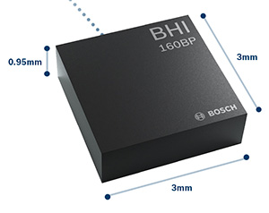
The BHI160BP position tracking smart sensor. (Photo: Bosch Sensortec)
Bosch Sensortec has released the BHI160BP, a position tracking smart sensor that uses integrated inertial sensors to improve GPS location tracking.
Bosch will exhibit the new sensor at Electronica Munich, Nov. 13-16.
When used with a GPS or GNSS module, the BHI160BP enables users to take full advantage of pedestrian position tracking with up to 80 percent saving in system power consumption compared with a typical GNSS-only solution, without compromising on accuracy, the company said.
Users benefit from greatly extended battery life and longer charging intervals for wearable applications such as smartwatches and fitness trackers as well as mobile devices such as smartphones.
The new position tracking approach is set to enable a new class of compact devices with even smaller batteries, Bosch claimed.
The BHI160BP tracks a person’s position by intelligently applying an inertial-sensor-based algorithm for pedestrian dead reckoning. To maintain accuracy, it calculates the user’s relative location based on data collected from the inertial sensors and then recalibrates itself every few minutes to obtain the absolute position provided by the GNSS/GPS module. This means that the GNSS/GPS module can be kept in sleep mode for most of the time, which drastically reduces a device’s power consumption and extends its operating time.
“Pedestrian position tracking is a crucial application for mobile applications; unfortunately, GPS modules can rapidly drain a device’s battery capacity — especially when the battery is as small as in wearable devices,” said Stefan Finkbeiner, CEO of Bosch Sensortec. “Our new position tracking smart sensor solves this problem and enables users to navigate reliably while extending the operation of GPS tracking in their devices from several hours up to several days.”
With the BHI160BP, a device can maintain solid accuracy even when the GNSS signal is blocked or weak, such as near tall buildings or indoors, the company added. This ensures accurate pedestrian navigation at all times, even in shielded indoor areas such as subways, Bosch said.
The BHI160BP is a new member of Bosch Sensortec’s BHI160 family and adds application-specific functionality for position tracking. It provides a ready-to-use solution that can be quickly and easily integrated into a system design without requiring an update to a new GNSS module, thereby significantly cutting time to market, Bosch said.
While the current configuration is optimized for use with GNSS receivers (such as GPS), the BHI160BP can also support most of the common global localization technologies. According to the company, the BHI160BP can handle gesture recognition and 3D orientation, with 3D calculations performed by the sensor itself rather than by an application processor.
The new BHI160BP draws 1.3 mA in active operation mode and integrates the company’s Fuser Core microcontroller and a six-axis inertial measurement unit. The BHI160BP offers a variety of customized virtual sensors, such as a calibrated accelerometer, orientation and wake-up gesture, within a single device. It BHI160BP can be extended by connecting additional physical sensors, such as a magnetometer, over a secondary interface.
The new BHI160BP comes in a compact 3 x 3 x 0.95 mm³ LGA-package and is pin-to-pin compatible with the BHI160. It will be available via distribution in December.
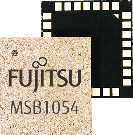
Fujitsu has introduced a low-power multi-GNSS module for consumer devices and asset tracking. (Graphic: Fujitsu)
The MSB1054 multi-receiver module requires no external components and has built-in Flash memory, meeting needs of smartwatches, fitness trackers, logistics and navigation.
Fujitsu Electronics Europe (FEEU) is expanding its ultra-low power portfolio to include a multi-receiver GNSS module: the MSB1054. The ability to receive signals from several satellite systems significantly reduces the time to first fix, providing for faster and more accurate positioning, the company said.
Photo: Fujitsu
Besides the GNSS device itself, the MSB1054 provides a built-in RF-front end (SAW filter, low-noise amplifier) as well as a temperature compensated crystal oscillator (TCXO), so with the exception of an antenna no external component is required.
Furthermore, Fujitsu’s GNSS module is equipped with a built-in Flash memory for quick “hot start” to save the navigation data and further optimize performance.
With its dimensions of 5.8×6.2×1 millimeters and 3.4 mA current in low-power mode (such as for tracking), the MSB1054 is designed for a variety of applications such as smartwatches, fitness trackers and asset tracking, and can navigate indoors or outdoors, the company added.