A free 12-day online course on GNSS will be offered by the Indian Institute of Remote Sensing (IIRS), part of the Indian Space Research Organization (ISRO).
“Overview of Global Navigation Satellite System” (Course-ID: 107) will be held Sept. 19-30. The course is designed to help with the urgent demand for trained manpower in remote sensing, geographic information systems (GIS), GNSS and associated geospatial technologies. The course will introduce GPS and GNSS, receivers, processing methods, errors and accuracy.
The course will cover the following topics:
GPS receivers, processing methods, errors and accuracy
satellite-based augmentation systems and GPS-aided and GEO-augmented navigation (GAGAN)
GPS signal characteristics and data formats (broadcast and precise ephemeris)
Indian Regional Navigation Satellite System (IRNSS)
DGPS demonstration
advanced GNSS processing
development of satellite navigation technology, TRANSIT, TSKLON, GNSS (GPS, GLONASS, Galileo and BeiDou), principles of GNSS, segments and applications
satellite navigation.
The course is open to undergraduate and postgraduate students; technical or scientific staff of central or state government; and faculty or researchers at university or institutions.
Course study materials — lecture slides, recorded video lectures, open-source software and handouts of demonstrations — will be made available through the IIRS learning management system E-CLASS.
GNSS Winter School 2021 is planned for Feb. 22-26 in Islamabad, Pakistan. The Institute of Space Technology is hosting the event, in collaboration with the Space Education Research Lab of the National Center of GIS and Space Applications.
GNSS Winter School will be held on the institute’s campus; however, in case of severe circumstances (such as COVID-19), it will take place virtually online either partially or entirely.
GNSS Winter School will focus on GNSS positioning, coordinate and time reference systems, satellite orbit and position determination, signals, receivers, and specialized areas of inertial and integrated navigation systems.
A special session is planned on GNSS applications and opportunities in the current GNSS market.
The school is intended for engineers, researchers and students working in aeronautics and astronautics; guidance, navigation and controls; satellite or radio navigation; inertial and integrated navigation systems; space systems; constellation designs; interplanetary navigation; remote sensing; geoinformation science; and similar allied areas.
“Diverse teams bring diverse ideas to the table, and that’s the best way to progress.”
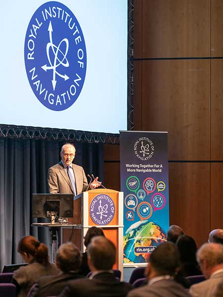
So said Professor Sheila Rowan, the UK government’s chief scientific advisor to Scotland, opening the Royal Institute of Navigation’s 2019 International Navigation Conference. Professor Rowan’s comments set the scene perfectly. Success in navigation is no longer about just getting a fix, or even an accurate fix. To succeed as a system or application provider, diversity and collaboration are key, whether it be multiple disciplines and the skills that go with them, or a mix of ages, beliefs and backgrounds. So, what were some key messages to emerge from four days of working together?
John Pottle opens the 2019 International Navigation Conference sponsored by the Royal Institute of Navigation (RIN). (Photo: RIN)
More practical help for non-experts wanting to improve resilience in positioning, navigation and timing (PNT) is needed. The top request from delegates at the pre-conference short course was for more detailed and specific information on threats to PNT. Of particular interest were how to measure the impacts and test the merits of various mitigation approaches. In other words: how to assess risk? How to decide what steps to take?
User acceptance and regulatory/legal structures for driverless vehicles are greater challenges than the positioning and communications technology. In the UK and across Europe, projects are under way to evaluate good practices for so-called “beyond line of sight” drone flights. For driverless cars, while huge strides have been taken to enable secure and resilient absolute and relative positioning, much remains to be done. Practical issues were highlighted, such as over-cautious vehicles and a tendency for driverless cars to make occupants feel more travel sick. So work needs to be done to avoid a stressfully slow and sickly experience.
Skills and knowledge are changing — and education/training needs to, too. A major developed-world problem is that the experts with experience who have seen generation after generation of technology evolution are now in their later careers or retired. Because of the wealth of knowledge vested in these individuals — we can all think of some, I’m sure — organizations have tended to over-rely on them. A key theme of the conference closing plenary was that the community wants to do more to collaborate — that word again — to define training needs and figure out how to deliver the skills that are needed today and tomorrow.
The next couple of years bring fewer, bigger navigation conferences in Europe. The European Navigation Conference (ENC) 2020 takes place in Dresden, May 11–14, organized by the German Institute of Navigation, DGON. ENC2021 will be combined with the triennial global congress of the International Association of Institutes of Navigation (IAIN), Nov. 15–18, 2021, in Edinburgh, organized by the Royal Institute of Navigation.
Please save the dates — joining these events is rewarding and stimulating as we work together toward a more navigable world.
John Pottle is director of the Royal Institute of Navigation.
NavtechGPS is offering the following multi-day training sessions on GNSS/GPS technology in New Orleans this December. Both courses will take place at the InterContinental New Orleans Hotel.
Take this 4-day course to gain a comprehensive understanding of GPS/GNSS system concepts, design and operation, including information on GPS signal processing by the receiver; techniques by which GPS obtains position, velocity and time and a brief introduction to differential GPS (DGPS) and Kalman filtering.
Expanded to a full five full days based on attendee requests, this course on GPS-aided navigation will thoroughly immerse you in the fundamental concepts and practical implementations of the various types of Kalman filters that optimally fuse GPS receiver measurements with a strapdown inertial navigation solution. The course includes the fundamentals of inertial navigation, inertial instrument technologies, technology surveys and trends, integration architectures, practical Kalman filter design techniques, case studies, and illustrative demonstrations using MATLAB.
Five fulls days allow for a fuller and detailed development of the design of an aided navigation system, combined with a detailed discussion of the use of lower quality IMUs, and advanced filtering techniques.
GeoLearn, a company focused on serving the geospatial industry with video-based online learning and continuing education credits, has added nine courses on geodesy topics by retired NGS Chief Geodetic Surveyor and GPS World contributor David Doyle.
Doyle is a contributing editor for survey to GPS World’s monthly Survey Scene newsletter. His first column appeared in May.
GeoLearn’s new introductory geodesy courses carry approval for professional development hours (PDHs) from the ABET-accredited geospatial program at Texas A&M University-Corpus Christi.
“I’ve been addressing groups of surveyors and other professionals who use NGS data. In these courses, I take those decades of interaction and try to anticipate and address the most common problems they’ve encountered and most of the questions they would ask,” Doyle said.
Doyle’s first eight courses are offered as a series, though students can pick and choose. The first is an introductory stage-setting course on geodetic fundamentals for those who have been hesitant to delve into any geodesy-related topic. It is an excellent primer for a broad spectrum of geospatial professionals and technicians in fields such as land surveying, engineering and technical GIS applications. The rest of the series includes two on classical horizontal datums and contemporary horizontal datums and two on vertical datums. He includes an additional course on future datums and another on coordinate systems.
Doyle’s ninth course uncovers the “secret sauce” to understanding and using NGS data sheets. It helps novices and experienced alike to understand all the clues and guideposts embedded in such sheets. He includes a discussion of how to understand the accuracy (horizontal and vertical) of various marks based on the metadata provided right in the data sheet. Also included is information on how to access photographs of the marks and how you can update the information using a simple program that you can download from the NGS website.
“Dave was of phenomenal service to geospatial professionals when he was with NGS,” said Joe Paiva, CEO of GeoLearn. “We are proud to be the only 24/7 education source that delivers Dave’s quality, video-based education on these needed topics.”
GEOINT 2015 attendees have the opportunity to sign up for the GEOINT Foreword pre-conference session, earn Continuing Education Units in 80+ hours of training, be among the first to take Universal GEOINT Certification exams, and much more. The United States Geospatial Intelligence Foundation (USGIF) has once again expanded its dedicated professional development offerings at the GEOINT 2015 Symposium, to be held June 22-25 at the Walter E. Washington Convention Center in Washington, D.C.
GEOINT Foreword
GEOINT 2015 kicks off with GEOINT Foreword, a pre-symposium science and technology-focused day designed to highlight advances in GEOINT tradecraft and innovation. In addition to a keynote speaker, lightning talks, and networking breaks, GEOINT Foreword will host 14 panel sessions on topics such as: utilizing commercial space and SmallSat assets; data science acquisition models; modeling and simulation; open-source apps; interoperability; and more. GEOINT Foreword requires separate registration.
Training & Education
The GEOINT 2015 agenda offers more than 80 hours of training and education sessions, which have more than doubled since last year’s Symposium. Two-hour training and education sessions will be conducted in both the morning and afternoon June 23-25. Session topics include crisis mapping, full-motion video, LiDAR, game engines, spatial literacy, GEOINT 101, commercial electro-optical imagery, point cloud technology, cognitive computing, and more. To participate in training, attendees must add desired sessions to their GEOINT 2015 registration. Training and education sessions are accredited by the International Association for Continuing Education and Training. Attendees will receive 0.2 Continuing Education Units per session courtesy of USGIF Member Riverside Research.
Universal GEOINT Certification
This fall, USGIF will launch its Universal GEOINT Certification.Each of the three exams required to achieve the certification will require beta testers. Pilot versions of the GIS and remote sensing exams will be administered at GEOINT 2015. Qualified symposium attendees will have the opportunity to take one or both exams for free to count toward their Universal GEOINT Certification. Attendees can add pilot exams to their GEOINT 2015 registration or email [email protected] to learn more.
Family Day
The GEOINT Symposium will for the first time feature a family day June 25 from 12:30 to 3 p.m. Attendees are invited to bring their families to explore the exhibit hall and participate in fun, interactive activities. USGIF’s Young Professionals Group will host a ScavenGeo Dash in the exhibit hall from 1-3 p.m. The dash is an educational scavenger hunt offering families a unique opportunity to learn about the GEOINT Community through an exciting competition. To sign up for the ScavenGeo Dash, email [email protected] and include the names and ages of your team members. Teams should not exceed six members.
To learn more about these educational offerings, view the full symposium agenda, or to register for GEOINT 2015, visit geoint2015.com.
GeoLearn is offering seven new GNSS courses taught by Bill Henning, a professional land surveyor who was instrumental in developing RTK guidelines for surveyors at the National Geodetic Survey (NGS). With GeoLearn, he expands on the basics of positioning with RTK and adds a special three-course series on heighting with GNSS.
Henning’s four courses on RTK dissect how GNSS works, covering the physics and surveying implications of what affects the signals from space, benefits and costs of single base versus real-time networks, and best field methods to maximize a surveyor’s effectiveness with RTK. His heighting series (three courses) covers the interrelationships between gravity and heights, use of the NGS hybrid geoid model and height modernization procedures, and use of the NGS 58 and 59 guidelines and real-time precision.
Instructor Bill Henning
“I’ve tried to incorporate the very latest in the science and practical knowledge that many have developed at NGS in collaboration with public and private partners on the subject of effective RTK use and heighting with GNSS,” Henning said.
“We were so pleased when Bill agreed to teach this series of courses,” said Joe Paiva, CEO of GeoLearn. “Bill is a national treasure to surveyors and we are pleased to be able to extend his legacy to the public beyond his tenure with NGS.”
With GeoLearn’s abilities, MSPS can provide more options to its members who seek continuing education opportunities. By accessing the online learning portal through the MSPS website, professional land surveyors and their staff can improve or refresh their knowledge base of land-surveying practices relevant to Missouri.
According to GeoLearn, the online interface is easy to use, affordable, and provides a tool to inventory all course work taken through GeoLearn for easily tracking continuing education credits earned. This is a modern way to get a quality service and course content that is specifically addressed to Missouri-licensed land surveyors. The coursework is available with no delay once a person is signed up for the presentation they select. There is also the convenience of being able to enter the portal and get continuing education credits anytime, at any place.
“We’re happy to partner with MSPS in providing online training,” said GeoLearn CEO Joe Paiva. “We’ve already collaborated with them, Seiler and Mo DOT in producing a free course for the public, on how to use the Missouri DOT Real Time (GPS) Network; many users, not just surveyors, have questions about the network, how they can access it and use it.” In addition, MSPS has launched two Missouri-specific courses on survey minimum standards, presented by J. Michael Flowers, PLS.
The Missouri Society of Professional Surveyors is the premier professional association in Missouri for those engaged in the practice of land surveying. Its purposes include representing the interests of, and to be the primary voice for, the surveying profession in the state; elevating the standards of practice for land surveying in the state for the benefit the public; supporting the general public and offices of public records by encouraging the delivery of superior land surveying services that upgrade land records; sponsoring legislation and educational programs beneficial to the public and land surveyors; and striving to improve the professional recognition of the profession by the public and other related professions.
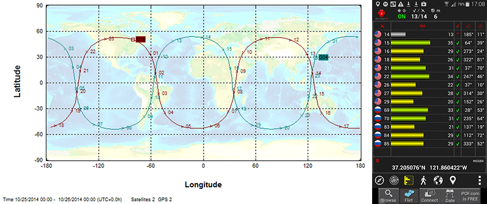
In this course assignment, the map predicts the satellite paths, and the app is what students use to observe them.
Final results are not yet in, but early indicators presage that Monday’s inaugural webinar with two Stanford professors will be the largest GNSS public event ever staged. Enrollment surpassed 20,000 some time ago, and the free subscription rolls are still open. It’s massive!
Per Enge, professor of engineering at Stanford University, where he directs the Stanford Center for Position Navigation and Time, and Frank van Diggelen, vice president of technology at Broadcom Corporation and a consulting professor at Stanford University, are teaching the massively open online course (MOOC) on GPS this fall. The six-week course began October 13 and lasts through November 24, but it’s not too late to enroll.
The course focuses on GPS basics with the use of smartphones.“This is the first ever MOOC on GPS/GNSS,” said van Diggelen. “It will be carried by Coursera.”
GPS: An Introduction to Satellite Navigation, with an interactive Worldwide Laboratory using Smartphones
Explore the fundamentals of the Global Positioning System (GPS) and how it works by conducting “backyard” laboratory experiments on your own mobile device. Learn the basics of satellite navigation and witness the power of a network with planet-wide coverage. Gain a deeper understanding of GPS and its role in our lives, while interacting with a worldwide community of learners and backyard scientists.
“Online learning, especially with MOOCs, is about to revolutionize teaching, and Stanford is in the vanguard,” van Diggelen added. “We’ve been teaching this course for several years at Stanford, and so this seems a very natural extension. We’re both excited by the possibility of reaching students all over the world, and by being part of the revolution.”
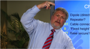
He provided some sample questions from set of short quiz exercises that will form part of the course.
What is the repeat period of the apparent orbit from a fixed point on earth, of a GLONASS satellite with orbit period 8/17 of a sidereal day?
What is 27 W in dBm?
Why is the bandwidth of the GPS C/A code signal one million cycles/second when it only sends data at 50 bits/second?
How precise are the GPS pseudo-range measurements?
Why is the fundamental GPS measurement called a pseudo-range?
There are even lab sessions. Participants will use their own smartphones or tablets.
A sample lab assignment: Predict which of the two GPS satellites, PRN 20 and PRN 32 will pass closest overhead at your location. Go outside at that time and verify that the GPS in your smartphone can acquire and track this satellite. Post the results on the course site, and watch who saw the satellite before you, and who sees it next.
“The class as a whole will follow these satellites around the world, as they tie us together in a global laboratory,” van Diggelen concluded, “using online apps that make the worldwide labs work.”
Frank van Diggelen
Frank van Diggelen is vice president of technology at Broadcom Corporation, a consulting professor at Stanford University, and inventor of coarse-time GNSS navigation, co-inventor of Long Term Orbits for A-GNSS, and author of A-GPS: Assisted GPS, GNSS, and SBAS. He is also a frequent contributor to GPS World.
Per Enge
Per Enge designs navigation systems that are safe and secure. He has worked on such systems for maritime and air applications. Two of these navigation systems have been deployed worldwide. He received his B.S.E.E. from the University of Massachusetts, and his M.S.E.E. and Ph.D. from the University of Illinois. Today, he is the Vance and Arlene Coffman Professor of Engineering at Stanford University, where he directs the Stanford Center for Position Navigation and Time. He was awarded the GPS World 2013 Leadership Award in the Signals category.
GeoLearn, a start-up devoted to servicing the geospatial industry with online learning and continuing education credits, has launched its website and training portal with an initial catalog of 22 one-hour-long courses taught by industry-leading faculty members. Course topics available at launch include “Unmanned Aerial Vehicles (UAV’s),” “ALTA/ACSM Land Title Surveys,” and “National Flood Plain Insurance.”
“We want to provide quality professional development to satisfy continuing education requirements that also enables you to deliver services to your clients from a higher quality knowledge base,” said GeoLearn Principal Joe Paiva. “You often have to get continuing education to satisfy licensing requirements; at GeoLearn you will also leave enriched — a plus for any geospatial organization.” While catering to professionals, GeoLearn will begin to build up courses suitable for technicians as well, including a series that supports those pursuing Certified Survey Technician (CST) status.
GeoLearn faculty members are nationally recognized experts in the geospatial field. Initial faculty include Gary Kent of the Schneider Corporation, Wendy Lathrop of Cadastral Consulting and GeoLearn Principal Joseph Paiva. More courses will come soon from other notable professionals in the geospatial industry.
“A key motivation to start GeoLearn has been the desire to significantly improve the learning experience for busy professionals and technicians,” said GeoLearn Principal Bob Morris. “With limited time availability and the growing cost of travel associated with more traditional methods of securing continuing education credits, we hope to provide an attractive option using of state-of-the-art multi-media through our online training portal.”
GeoLearn has invested in a multi-camera video production studio optimized for online learning, and hired Emmy Award-winning marketing and video expert Peter Barrett to head up those efforts.
 A free 12-day online course on GNSS will be offered by the Indian Institute of Remote Sensing (IIRS), part of the Indian Space Research Organization (ISRO).