Galileo satellites 13 and 14 have begun transmitting navigation signals as fully operational members of the constellation.
The pair were launched from Europe’s Spaceport in French Guiana on May 24.
After launch and maneuvers to reach their final orbital altitude, their navigation and search-and-rescue payloads were methodically switched on and checked out. Their performance was assessed in relation to the rest of Galileo system.
Europe’s 13th and 14th Galileo satellites being encapsulated inside their launcher fairing. (Photo: ESA)
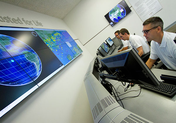
This lengthy test phase saw the satellites being run from the second Galileo Control Centre in Oberpfaffenhofen, Germany, while their payloads’ output was assessed from the European Space Agency’s (ESA’s) Redu centre in Belgium, equipped for the tests with specialized antennas for receiving and uplinking signals.
The test campaign measured the accuracy and stability of the satellites’ atomic clocks — essential for the timing precision to within a billionth of a second as the basis of satellite navigation — as well as assessing the quality of the navigation signals.
Oberpfaffenhofen and Redu were linked for the entire campaign, allowing the team to compare Galileo signals with satellite telemetry in near-real time, according to ESA.
These two satellites were visible in the sky above Redu for a limited time each day, ranging from three to nine hours, so tests were scheduled accordingly.
Now that in-orbit testing is completed, the satellites are transmitting working navigation signals and are ready to relay any Cospas–Sarsat distress calls to emergency services.
The next four satellites, launched together on Nov. 17, are beginning the same in-orbit testing activity, with the aim of joining the network next spring.
Jeremie Godet, Galileo Implementation Head of Sector, European Commission (left); Fiammetta Diani, deputy head of Market Development, European GNSS Agency.
By Jérémie Godet and Fiammetta Diani
The Galileo programme is currently in its deployment phase, which is due for completion in 2020. Following declaration of initial services in 2016, an exploitation phase will start and aim at delivering a fully operational system by the end of 2020. The deployment and the exploitation are entirely financed through the budget of the European Union, while two non-EU members, Norway and Switzerland, contribute through international agreements.
The aim of the Galileo programme is to establish and operate the first global satellite navigation system under the control of the European Union, thus contributing, amongst other things, to the strategic autonomy of the Union. This is the first time that the EU has developed, owned and been responsible for such a large-scale infrastructure.
While independence is the main political objective, ensuring compatibility and interoperability with other existing and future systems is also critical. Indeed, frequency compatibility has been achieved with GPS, IRNSS, QZSS and COMPASS with a range of coordinations achieved in the last two years under the framework of the International Telecommunication Union (ITU). A wider international agreement was previously reached in 2004 between the U.S and the EU, achieving the compatibility and interoperability of their respective systems and resulting in a common modulation for both systems’ state-of-the-art open signals. A positive outcome of this for all GNSS users is that similar signals have been adopted by other global or regional systems, in particular the MBOC modulation jointly defined by the U.S. and the EU (Galileo, GPS, COMPASS, QZSS), the ALTBOC modulation adopted by COMPASS and a common signal in E6 adopted by QZSS.
The Galileo programme will provide unique services, functionalities and performance levels that have never, or not yet, been provided by other satellites navigation providers.
What Will Users Get, and When?
These services, defined in consultation with user communities and EU Member States, will be offered by the system:
An Open Service (OS): With positioning accurate to around 1 meter using up to three different frequencies (E5a, E5b and L1), free of charge to the user and providing positioning and synchronization information intended mainly for high-volume satellite navigation applications;
A Public Regulated Service (PRS): Restricted to government-authorized users, for sensitive applications which require a high level of service continuity. It will use strong encrypted signals. This service is intended for security-related use for the EU Member States, the European Council, the European Commission, the European External Action Service and duly authorized Union agencies. It may be accessed by non-EU states and international organizations subject to bilateral agreements.
A contribution to the Search and Rescue Service (SAR) of the COSPAS-SARSAT system: Galileo’s worldwide search-and-rescue service will help to forward distress signals to a rescue coordination center by detecting emergency signals from beacons and relaying messages to them in near real time.
A contribution to integrity monitoring services by means of Galileo OS signals, in cooperation with other satellite navigation systems, aimed at users of safety-of-life applications in compliance with international standards;
A Commercial Service (CS): Encrypted for authentication purposes and offering very high accuracy to the sub-decimeter level, it will target applications for professional or commercial use owing to improved performance and data with greater added value than that obtained through the open service.
As of 2016, Galileo will progressively offer initial services for the open service, search-and-rescue service and the public regulated service. Those initial services will be gradually improved, and the other two services will be gradually implemented, with the aim of reaching full operational capability by end 2020.
The performance improvements of the services expected between 2016 and 2020 are linked to completion of the constellation deployment. In 2018, this will reach 24 satellites, the number required to achieve Galileo’s positioning performance targets, and the completed constellation with up to 30 satellites will be in place by the end of 2020 to provide the necessary spares to ensure performance commitments.
On top of this, a number of additional capabilities are planned to be added to the core services, including:
An improvement of the OS nav message with full backward compatibility to enhance both the time-to-first-fix and the ability to perform signal acquisition and tracking for users in lower visibility conditions (INAV improvement);
An authentication of the OS navigation message allowing users to verify that a certain number of broadcast parameters are the actual Galileo data — aimed at applications requiring trusted position and timing information for commercial purposes;
An improvement of the PRS;
A new functionality within SAR that provides, via the navigation message, a Return Link Message to distress beacons acknowledging that a rescue center has received their distress signal.
Constellation Status
The current Galileo constellation is composed of two different families of satellites: the In-Orbit-Validation (IOV) satellites procured before 2010 and the Full-Operational-Capability (FOC) satellites procured after 2010. Since the last Galileo launch on Sept. 10, there are four IOV satellites and six FOC satellites in orbit. The FOC satellites have improved capabilities regarding signal transmission compared to the IOV satellites, despite a similar mass and size. The FOC satellites carry a SAR payload; two IOV satellites have this capability. While this initial deployment faced a number of difficulties, these are now well behind us.
Sixteen more FOC satellites are being built. The next launch of two FOC satellites is scheduled for Dec. 17, and four more launches (three Ariane 5 and one Soyuz) are foreseen from 2016 to mid-2018. This implies four to six satellites launched per year, and this is judged perfectly realistic as demonstrated already in 2015.
An additional series of satellites will be procured in 2016 for deployment starting in late 2019/early 2020.
Preparing to Use and Benefit
The ultimate objective of the Galileo program is for its signals to be translated into valuable and reliable services for users across the globe. Europe aims to generate the return on investments in terms of public benefits for citizens and businesses, and for this reason the users are at center of the program.
This is the focus of the European GNSS Agency (GSA), which is in constant dialog with user communities via a wide range of activities.
For example, cooperation with chipset and receiver manufacturers aims to ensure that all products are Galileo-ready. This process involved a successful testing campaign done in cooperation with ESA and the EC’s Joint Research Centre (JRC). Equally important is to work closely with large user communities, such as road, maritime and rail, to support them in updating their systems so that they are ready to use Galileo. This is accomplished by dedicated market and technical support, via cost-benefit analyses, testing campaigns, initiation of standards and certification processes, user satisfaction surveys and more. These actions are part of tailored adoption roadmaps built with each user community. Periodic user fora are also organised to get feedback on current services and collect ideas for the evolution of the European GNSS systems.
EU R&D programmes, such as Horizon 2020 for the development of Galileo applications as well as the recently launched Fundamental Elements program that focuses on funding European GNSS chipset and receiver technologies, are essential tools for preparing users and supporting EU competitiveness in the downstream sector.
The GSA leverages these EU R&D programmes as a tool for adoption with large user communities and receiver manufacturers fully involved. The projects are managed by experienced staff specialised in different markets and application areas. In the case of PRS, the core user equipment technology is being designed and tested. This work is already paying off; today, a growing number of receivers available on the global market are Galileo-enabled, while almost 70 percent of the models have EGNOS.
Among others, Europe’s ST Microelectronics in the automotive sector, and the U.S.’s Broadcom and the Taiwanese Mediatek in smartphones, have already announced their Galileo-ready chipsets. Many other chipset manufacturers are ready and tested for Galileo. It is expected that, with recent successful launches and the deployment schedule, most of them will bring their Galileo products to market in 2016.
Galileo on the Horizon
Despite its particularly challenging complexity, involving extensive technical and security requirements, Galileo deployment is now progressing well and services will be provided starting in 2016, to reach their full operational capability in 2020. One early benefit of interoperability with GPS is that even before the Galileo constellation is completed, the number of L5/E5a signals in space will allow meaningful use of that frequency for the first time. Galileo will deliver real advances in precision, availability, coverage and additional features unprecedented in any other satellite navigation systems to date: while GPS is today’s de facto standard, Galileo is aiming to be the world’s second GNSS reference system by 2020.
Governance Set-up
The European Commission (EC) has overall programme supervision and budget responsibilities. The EC delegates system design and infrastructure procurement to the European Space Agency (ESA) and service preparation, delivery and operations to the European GNSS Agency (GSA). ESA is one of founders of the Galileo system and has been responsible for the development phase, co-financed by the Member States of ESA and the EU. ESA is the procurement agent of core infrastructure and in charge of the overall system integration since 2007.
The GSA’s role will grow considerably in the exploitation phase as it becomes the day-to-day interface with ESA in several areas, including infrastructure roll-out and maintenance. The GSA will procure main operations of the system from 2017 and will operate key services facilities such as the Galileo Security Monitoring Centre in France and the UK, the European GNSS Service Centre in Spain, and the Galileo Reference Centre in the Netherlands. The GSA also supports the enabling of receivers and chipsets for Galileo use and the development of applications in downstream segments, in close cooperation with the major user communities.
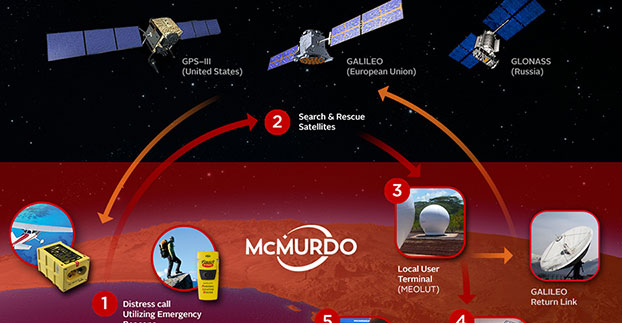
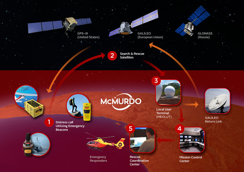
In a typical Cospas-Sarsat search and rescue process, a distress beacon signal is sent via satellite to a local user terminal. A mission control center validates the emergency and sends critical information to rescue coordination centers. MEOSAR, the next-generation version of Cospas-Sarsat, will provide several unique features including a return link service function to acknowledge receipt of the distress signal.
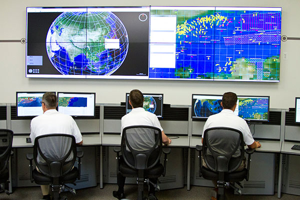
McMurdo has introduced PRISMA MCCNet, a new software solution with several new features to improve the Cospas-Sarsat satellite-aided search and rescue process, and for use in the future MEOSAR system. The software, which is part of McMurdo’s suite of PRISMA (Preparation, Response, Identification, Surveillance, Management, Acceleration) software solutions, provides mission control center (MCC) operators with critical tools to better identify, locate and manage distress situations.
In a typical Cospas-Sarsat search and rescue scenario, a distress signal from an emergency beacon is sent via satellite to a fixed ground receiving station or local user terminal. The nearby MCC confirms the emergency, analyzes location data and provides this information to the various rescue coordination centers for the actual rescue operation. PRISMA MCC’s improved functionality includes built-in system redundancy, unified communications and automated reporting to improve the MCC operation and streamline the search and rescue process.
The international Cospas-Sarsat satellite system is best known for detecting and locating emergency beacons activated by aircraft, ships and backcountry hikers in distress and has been credited with saving 37,000 lives since 1982. The system includes satellites in low-altitude Earth orbit (LEO) and geostationary Earth orbit (GEO). The future Cospas-Sarsat system will include medium-altitude Earth orbit (MEO), which will form the MEOSAR system. Satellites in the MEOSAR system include GPS, Galileo and GLONASS satellites, which are incorporating search and rescue payloads.
“PRISMA MCCNet provides Mission Control Center operators with a powerful, comprehensive and reliable software tool that provides the most accurate data and most up-to-date information to expedite the search and rescue process,” said Jacob Blankenship, search and rescue business manager for McMurdo. “With several advanced features and innovative functions based on our years of experience working with the leading search and rescue authorities around the world, the end result will be faster decision making and, ultimately, more lives saved.”
McMurdo’s PRISMA MCCNet software will help improve a Cospas-Sarsat satellite-aided search and rescue system that has helped to save 37,000 lives since 1982.
PRISMA MCCNet provides significant improvements in several key areas to enhance mission control center operations including:
High Availability with Support for Automatic Failover — PRISMA MCCNet includes new automatic failover and built-in redundancy features to maximize availability and uptime of the search and rescue system.
Unified Inbox and Communications — Easy to use and organize, PRISMA MCCNet’s Unified Inbox displays all actionable events that require operator interactions including beacon alerts, narrative messages, or system level alarms on a single screen. This information, which traditionally required the use of multiple screens, can be sent easily and reliably to rescue authorities via multiple communications protocols and redundant link transmission.
Advanced Monitoring and Reporting — PRISMA MCCNet’s built-in automatic diagnostic and analytical tools continuously detect, trace, and report malfunctioning components and processes. Quality Management System (QMS) analysis tools provide real-time tracking of system performance.
Client-Server Architecture — Unlike traditional MCC systems, PRISMA MCCNet is based on a secure and scalable client-server architecture allowing multiple MCC workstations to access consistent data and information from a centralized or distributed server configuration.
Commissionable LEOSAR/GEOSAR/MEOSAR MCC — PRISMA MCCNet was developed in close association with Cospas-Sarsat, National Oceanic and Atmospheric Administration (NOAA), NASA and other search and rescue authorities. This ensures a seamless commission/certification process for LEOSAR/GEOSAR/MEOSAR MCCs.
McMurdo’s PRISMA MCCNet software streamlines mission control center operations with features including built-in system redundancy, a unified inbox and advanced monitoring tools.
“The launch of PRISMA MCCNet is yet another milestone in McMurdo’s journey to become the global leader in emergency readiness and response,” said Jean-Yves Courtois, McMurdo CEO. “It provides a solid foundation upon which we can build a world-class, integrated ecosystem of products, technologies and services for preventing emergencies, protecting assets and saving lives.”
McMurdo provides the world’s only complete, end-to-end emergency readiness and response solution including distress beacons, search and rescue satellite infrastructure, mission control and rescue coordination centers and maritime domain awareness solutions including coastal surveillance and vessel monitoring systems. The world’s leading search and rescue authorities in the U.S. (NOAA and NASA), Australia (Australia Maritime Safety Authority), New Zealand (Maritime New Zealand), Cyprus, South Africa, Argentina and other countries use McMurdo search and rescue systems.
The Canadian government will begin providing search-and-rescue repeaters for the U.S. Air Force’s GPS III satellites, reports Space News. The repeaters provided by Canada’s Medium Earth Orbit Search and Rescue (MEOSAR) satellite project will significantly reduce the time it takes to locate a distress signal.
Canada’s Department of National Defence will begin negotiations with the U.S. Air Force to install 24 repeaters on GPS III satellites, starting with the 11th GPS III satellite. Canada’s MEOSAR satellite project includes construction of three ground stations, to be built by 2020.
The MEOSAR satellite payload is being developed for GPS III satellites.
The Canadian government first announced the MEOSAR project in 2013, awarding Com Dev International of Cambridge, Ontario, an initial contract worth 4.7 million Canadian dollars for research and design work on the repeaters. Despite completion of that phase, Canada’s Department of National Defence put the project on hold, possibly for budgetary reasons.
A contract award for the MEOSAR repeaters is now expected to be announced next year.
A MEOSAR repeater will be able to detect signals from emergency beacons and retransmit the signals to receiver stations on the ground. The emergency messages can then be sent to appropriate authorities so that people in danger can be quickly located and rescued.
MEOSAR will provide a more capable system than COSPAS-SARSAT, an international satellite-based search and rescue distress alert detection system established by Canada, France, the former Soviet Union and the United States in 1979. It is credited with saving more than 33,000 lives since its inception. MEOSAR will reduce the time it takes to detect and locate a distress signal from an hour to around five minutes.
Com Dev began the development of its MEOSAR technology in 2008 under a cost-shared research and development project with the Canadian Space Agency. Canada’s National Search and Rescue Secretariat also later provided additional R&D support.
The search and rescue transponders were originally destined for Galileo, according to Space News, but stalled because Canada lacked a defense certificate to be able to supply the Galileo program.
McMurdo has opened an Emergency Readiness and Response Experience Center at its Washington, D.C., location. The center will showcase the latest innovations and technology developments for search and rescue (SAR) in an immersive experience with real-time demonstrations of the entire SAR process — from distress beacon activation to satellite-based location detection to emergency response coordination.
The facility will feature a working MEOSAR (Medium Earth Orbit Search and Rescue) satellite-based search and rescue system, the next-generation version of the current Cospas-Sarsat satellite system that has saved more than 37,000 lives since 1982. When fully deployed in the next 3 to 5 years, MEOSAR will greatly improve the existing SAR process with global coverage, near instantaneous distress beacon detection and a unique Return Link Service feature that acknowledges distress signal receipt. MEOSAR’s advanced technologies will be able to accurately detect and locate a distress beacon signal almost instantaneously instead of taking up to 30 minutes today.
Visitors to the center will gain an understanding of the different search and rescue technologies by taking part in various search and rescue scenarios. Participants will also have the opportunity to sit at the controls of mission control center and rescue coordination center systems, similar to the McMurdo solutions used around the world by NASA, National Oceanic and Atmospheric Administration (NOAA), Australia Maritime Safety Authority (AMSA), Maritime New Zealand (MNZ) and other SAR authorities.
“This cutting-edge Experience Center allows us to demonstrate the incredible advancements being made in search and rescue all in a single location,” said Jean-Yves Courtois, CEO of McMurdo. “Our decades of experience in pioneering the latest SAR advancements, our leadership position as the only company that provides an end-to-end SAR ecosystem and our ongoing commitment to saving lives put us in the unique position to showcase these emergency readiness and response solutions for our customers, our partners and the industry.”
Guests will also see SAR-enhanced applications such as fleet management, coastal surveillance and innovative partner solutions for aviation, fishing, maritime, military and other industries. Classroom training and other educational sessions led by industry experts and SAR specialists will take place at the new center.
“The McMurdo Experience Center is unique in its ability to make the entire search and rescue process come to life, which we haven’t seen done before in a centralized setting,” said Bruce Reid, CEO, International Maritime Rescue Federation (IMRF). “We at the IMRF are delighted to be working with McMurdo on a variety of SAR training, education and awareness activities. Access to this location as a true center of excellence for the search and rescue sector can only enhance this activity.”
Personalized, custom tours of the McMurdo Experience Center for customers, partners and press can be reserved.
McMurdo products and services are used by some of the biggest names in the world including Airbus, Boeing, British Airways, Embraer, Southwest and United Airlines as well as the British Royal Navy, U.S. Coast Guard and numerous global search and rescue authorities. McMurdo was instrumental in the high-profile rescue of Clipper Round the World Race Sailor Andrew Taylor and was recently named as the official safety beacon partner of the hit reality series Deadliest Catch.
One of the Honeywell Global Tracking ESA installations.
Honeywell’s Global Tracking solution has passed the final acceptance test for use on the European Space Agency’s (ESA) Galileo search and rescue program by demonstrating dramatically reduced emergency response times, Honeywell said.
Honeywell Global Tracking, part of Honeywell’s Scanning and Mobility business, is working in partnership with the Aerospace & Defense division of Capgemini, the prime contractor for the Galileo search and rescue program, to deliver a high-precision positioning system that is fully compatible with the international standard, which is known as the Cospas-Sarsat standard. Tests using the Honeywell system have proven that the time from beacon transmission to detection and processing has been reduced from several hours to a few minutes — often the difference between life and death in an emergency situation.
The international Cospas-Sarsat program is a satellite-based search and rescue distress alert detection and information distribution system, best known for detecting and locating emergency beacons activated by aircraft, ships and remotely located people in distress. Honeywell’s satellite tracking technology, which detects faint alerts sent by emergency beacons around the world using a combination of Doppler curves, noise reduction, and advanced signal processing, quickly calculates the exact location of the beacon and sends the results to the relevant Mission Control Centers in the region.
“Our Medium Earth Orbit-based search and rescue solution will lead to faster recovery missions and improved international search and rescue operations, and we’re pleased to partner with the European Space Agency to help execute on this important, life-saving system,” said David Sharratt, general manager, Honeywell Global Tracking. “With decades of experience developing this technology, Honeywell Global Tracking is the global leader of search and rescue solutions.”
“Up until now, Cospas-Sarsat has relied on satellites in low and high orbits, but medium orbits with satellites such as Galileo are better for search and rescue purposes; they combine a wide field of view with strong Doppler shift, making it more likely a distress signal is pinpointed promptly and accurately,” said Fermin Alvarez, ground station and fielding engineer with ESA. “Together with Honeywell, we are encouraged to see Galileo performing so strongly, thereby solidifying our ability to support precise and speedy search and rescue efforts.”
The first GLONASS-K2 spacecraft will be launched into orbit in 2018, said Nicholas Testoyedov, the CEO of Information Satellite Systems Reshetnev, as reported by the Assotsiatsiya GLONASS/GNSS Forum.
“In 2018, we are preparing to launch the first satellite of the series GLONASS-K2,” Testoyedov said. “This satellite has advanced features. In the development of the navigation functions, new code division signals will be emitted, so it will provide more accurate positioning for users and more accurate tethering in those systems where important accurate time reference is required, such as in computer systems, connected devices, and so on.”
Testoyedov added that the GLONASS-K2 satellite will have equipment installed that makes it compatible with the international search and rescue system Cospas–Sarsat.
Budget Cuts. The budget of the GLONASS federal target program (FTP) for 2015 will be cut by more than 5 billion rubles, according to Russian news reports. After spending cuts, the budget for the current year will amount to 42.5 billion rubles, a cut of more than 10 percent, which is the average size of cuts for the entire “Space activities of Russia for 2013-2020” budget group.
McMurdo Group, maker of end-to-end search and rescue solutions, has received formal certification from the U.S. Federal Aviation Administration (FAA) and European Aviation Safety Agency (EASA) for its Kannad Integra ARINC 429 Navigation Interface.
Based on the ARINC 429 GPS communications standard for most commercial aircraft, the interface, when used with the Kannad Integra Emergency Locator Transmitter (ELT), provides dual GPS redundancy that can result in aircraft being found much faster compared to standard ELTs in event of an emergency. The solution has already been selected by aircraft manufacturers including Pilatus, Embraer and Airbus Helicopters.
Traditional ELTs rely on an aircraft’s external antenna and GPS equipment, which is subject to failure in the event of an emergency. The Kannad Integra ELT, however, can operate independently of the aircraft to provide key positioning data through its built-in internal antenna and embedded GPS receiver. The Integra ARINC 429 navigation interface stores the latest known position of the aircraft based on the aircraft navigation system data. This data is then used by the built-in Integra GPS for better location accuracy and a higher chance of rescue.
The Kannad Integra ELT and Integra ARINC 429 Navigation Interface are suitable for commercial aircraft, helicopters, business jets and airlines. Once activated, the Integra ELT transmits a distress signal to alert international rescue services to the emergency location via the global Cospas-Sarsat Search and Rescue satellite system, which has helped to save more than 37,000 lives since 1982.
“McMurdo’s Kannad products have been chosen by the world’s leading aircraft manufacturers and airlines for their quality, reliability and innovation,” said Christian Belleux, head of McMurdo’s Kannad Aviation Business Unit. “This new ARINC 429 interface is yet another example of how we are helping to shape the present and the future of aviation safety.”
A new emergency locator transmitter for aviation has received Cospas-Sarsat and FAA approvals and is now available for sale. The ELT 1000 by ACR Electronics, Inc., is designed with multiple installation configurations to reduce overall installation cost, the company said.
The electronics maximize frequency stability and power while incorporating a new, built-in GPS navigational interface, the company said. Including GPS data in the emergency transmission allows search-and-rescue personnel to know the location within 100 meters in less than a minute. Designed to accommodate multiple installation configurations, the new ELT 1000 is a quick retrofit for obsolete 121.5 MHz ELTs.
“We are very excited to announce this new ELT to the general aviation market. This is the first new ELT from the Artex family in many years and the first we have designed and certified at ACR. We feel we are bringing an ELT that offers excellent value, along with the highest quality workmanship available to the market,” said Gerald Angeli, president and general manager.
Built under the exacting standards of AS9100C quality certification, the ELT 1000 exceeds all government and regulatory standards including the latest FAA guidelines with its new robust stainless steel mounting strap.
ELT 1000 features and specifications:
Quick and easy retrofit for general aviation aircraft
Single antenna output for emergency transmission on both 406 MHz (Cospas-Sarsat) and 121.5 MHz frequencies (local Search & Rescue)
Enhanced positional accuracy with a built-in GPS interface that does not require aircraft power
Encoded digital message broadcasts aircraft identification/registration and owner/emergency contact details
New stainless steel mounting strap for increased stability that complies with the most current FAA guidelines
Simple self-testing from the cockpit. When combined with 406Test.com, the self-test will provide SMS/e-mail confirmation within seconds that the ELT signal reached the satellites successfully
New hermetically sealed G-Switch for increased reliability.
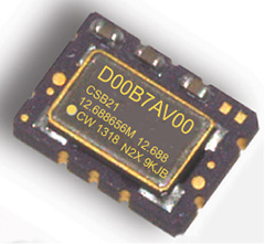
COSPAS-SARSAT beacons are battery operated emergency distress transmitters for locating ships or persons when time is critical for survival. The new Connor-Winfield series CSBxx Series are Surface Mount, 5x7mm, 3.3V, LVCMOS or Clipped Sinewave Temperature Compensated Crystal Oscillators (TCXO) designed to be emergency beacon frequency references requiring tight ± 0.2 ppm frequency stability and frequency slope control of only ±0.7 ppb/min.
The low power dissipation of 6mW allows it to power-up immediately with an accurate frequency. Class 1 devices operate over –40°C to 55°C and Class 2 devices operate–20°C to 55°C. Standard frequencies are 10.0, 12.688375, 12.688575, 12.688656, 12.68875, 16.367, and 20.0 MHz. To save time during the beacon certification process, temperature test data is available from a special on-line URL for each serialized TCXO.
Features:
3.3 Vdc Operation
Frequency Stability: ± 0.20 ppm
Mean Slope = ±0.7 ppb/min
Temperature Ranges Available:
Class I -40 to 55°C , Class II -20 to 55°C
LVCMOS or Clipped Sinewave Output
Ceramic Surface Mount Package
Tape and Reel Packaging
RoHS Compliant / Pb Free
Each unit is serialized and data is available on-line
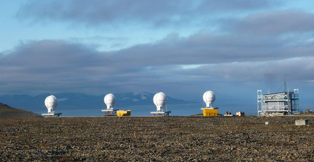
Svalbard station on Spitsbergen in the Norwegian Arctic.
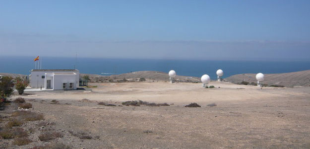
The European Space Agency’s completion of a pair of dedicated ground stations at opposite ends of Europe has enabled Galileo satellites in orbit to participate in global testing of the Cospas–Sarsat search and rescue system.The Maspalomas station, at the southern end of the largest island of the Canary Islands, at the southern fringe of European waters, was activated in June. And this last month has seen the Svalbard site on Spitsbergen in the Norwegian Arctic come on line — the two sites can already communicate and will soon be performing joint tests.
This speedy progress has enabled the participation of the latest two Galileo satellites in an international demonstration and evaluation program — a worldwide test campaign for a new expansion of the world’s oldest and largest satellite-based rescue system, Cospas–Sarsat.
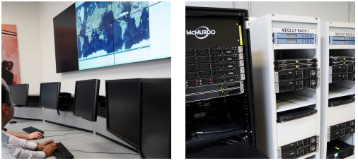
The Maspalomas station in the Canary Island has an ESA-built Maspalomas Medium-Earth Orbit Local User Terminal (MEOLUT).
Founded by Canada, France, Russia and the U.S., Cospas–Sarsat has assisted in the rescue of tens of thousands of souls in its three decades of service. Distress signals from across the globe are detected by satellites, then swiftly relayed to the nearest search and rescue (SAR) authorities.
Now the program is introducing a new medium-orbit SAR system to improve coverage and response times, with the Galileo satellites in the vanguard of this major expansion.
Supporting search and rescue is a separate function to Galileo’s main task of providing global navigation and timing services, but no less important.
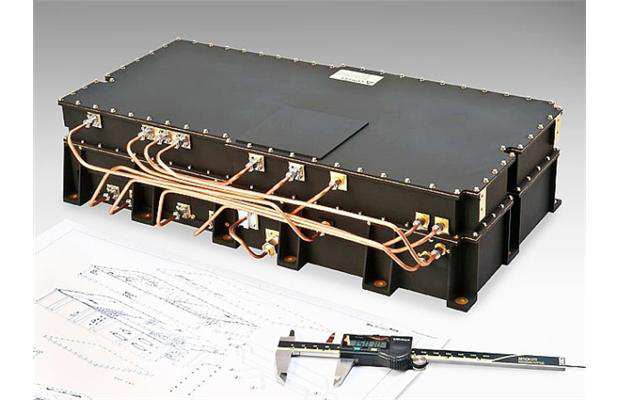
The second pair of Europe’s Galileo satellites — launched together on 12 October last year — are the first of the constellation to host SAR payloads. These can pick up UHF signals from emergency beacons aboard ships, aircraft or carried by individuals, which are then relayed to ground stations. There, the source is pinpointed and automatically passed on to a control center, which then routes it to local authorities for rescue.
“The Galileo satellites, tested in combination with the same SAR payloads on Russian Glonass satellites as well as compatible repeaters on a pair of US GPS satellites, showed an ability to pinpoint simulated emergency beacons down to an accuracy of 2-5 km in a matter of minutes,” explained ESA’s Galileo SAR engineer, Igor Stojkovic.
“Our in-orbit validation tests so far have been in line with expectation and beyond, giving us a lot of confidence in the performance of the final system, once completed.
“And using a combination of satellites is just how the upgraded system will operate in practice, in order to localise distress signals.”
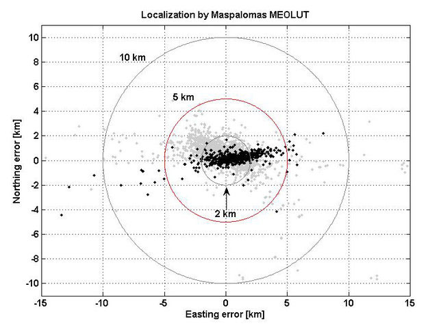
Localization test performed from the Maspalomas MEOLUT on 29-30 July 2013 as part of Galileo’s search and rescue in-orbit validation. Beacon locations obtained with four satellites are shown in black, while those using three satellites are shown in grey. More than 93% of all beacon locations, after only a single beacon burst has been received, are within the required 5 km from the actual beacon position.
The first switch-on of a Galileo search and rescue package shows it to be working well, according to the European Space Agency. Its activation begins a major expansion of the space-based Cospas–Sarsat network, which brings help to air and sea vessels in distress.
The second pair of Europe’s Galileo navigation satellites — launched together on October 12 last year — are the first of the constellation to host SAR search and rescue repeaters. These can pick up UHF signals from emergency beacons aboard ships and aircraft or carried by individuals, then pass them on to local authorities for rescue.
Galileo search and rescue repeater signal.
Once the satellites reached their 23,222 km-altitude orbits, a rigorous test campaign began. The turn of the SAR repeater aboard the third Galileo satellite came on January 17.
“At this stage, our main objective is to check the repeater has not been damaged by launch,” explained ESA’s Galileo SAR engineer Igor Stojkovic. “The first day was a matter of turning the repeater on and checking its temperature and power profiles were as predicted. The following day involved sending a signal to the repeater using the UHF antenna at ESA’s Redu Centre in Belgium, then picking up the reply from our L-band antenna.”
Redu’s antenna is 20 meters in diameter, so the shape of the relayed signal was captured in great detail, out of all proportion to surrounding noise.
“We can precisely measure its power, the time the relay took and so on,” added Igor.
More detailed system testing will follow, to completely prove this new type of SAR payload in orbit.
Cospas–Sarsat system.
The international system has been in use for more than three decades, saving some 31,000 lives. Cospas is a Russian acronym for “Space System for the Search of Vessels in Distress,” with Cospas standing for “Search and Rescue Satellite-Aided Tracking.” Ground stations — known as Local User Terminals — pinpoint the source of distress calls using signals relayed by participating satellites, then alert local authorities.
The GPS satellites will also provide a medium-Earth-orbit Sarsat capability and testing is underway. All nine Block IIR satellites carry experimental payloads and all IIF satellites are scheduled to. See “The Distress Alerting Satellite System” for more details.