Tag: COTS

  • Emcore’s EN-300 FOG IMU in high-rate production

    Emcore’s EN-300 FOG IMU in high-rate production

    EN-300 Precision Fiber Optic IMU/INS (Photo: Emcore)
    EN-300 Precision Fiber Optic IMU/INS (Photo: Emcore)

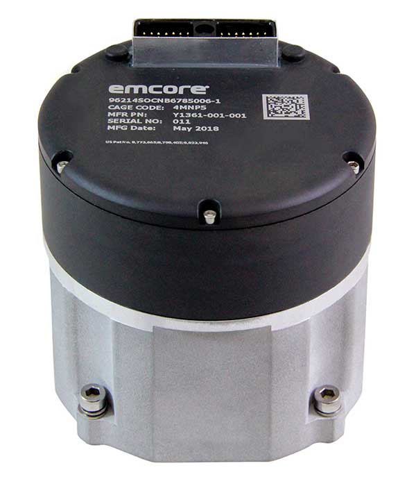
    Emcore Corp.’s EN-300 FOG (fiber optic gyro) inertial measurement unit (IMU) is now in high-rate production and is broadly available for purchase with 12-week lead times. The EN-300 was announced in April.

    Based in Alhambra, California, Emcore providees advanced mixed-signal products that serve the aerospace, defense and broadband communications markets.

    Emcore’s EN-300 offers up to 10 times the bias performance of legacy systems in a form, fit and function compatible package, the company said. This improved performance makes the EN-300 suitable for GPS-denied navigation, precise targeting and line-of-sight stabilization requirements for unmanned aerial vehicles as well as other demanding applications.

    Emcore has successfully completed a comprehensive Design Verification Testing (DVT) regimen over tough environmental conditions and has provided numerous proof-of-technology IMUs globally to defense contractor primes and aerospace customers seeking to upgrade their platforms and systems. Emcore is now expanding production of the EN-300 with strict manufacturing process and quality controls in place to enhance on-time delivery and specification compliance.

    “Given the strong market interest and demand, we are extremely pleased to announce the production ramp-up and broad availability for purchase of the EN-300,” said David Hoyh, Emcore’s director of sales & marketing for navigation products. “Emcore’s vertical integration creates unique capabilities that enable us to deliver the higher level of performance demanded by the market, coupled with greater precision and lower cost to further benefit our customers.”

    According to Emcore, the EN-300 precision FOG IMU is a three-axis, closed-loop design using the Company’s proprietary, solid-state FOG transceiver with advanced integrated optics, offering improved reliability and lower cost than legacy IMUs. It can be ordered with performance options tailored to specific customer requirements.

    The COTS (commercial off-the-shelf) EN-300-3 model achieves bias in-run stability as low as 0.04 degree/hr with ARW (Angle Random Walk) of 0.015 degree/rt-hr. The non-ITAR EN-300 is superior in performance to older generation such as the closed-loop LN-200 IMU or open-loop KVH 1750 series IMU units that have higher bias over temperature drift.

  • Lockheed completes COTS upgrade of ground control system

    Lockheed completes COTS upgrade of ground control system

    Lockheed Martin has completed a major upgrade to modernize the current ground control system of the U.S. Air Force’s GPS constellation.

    The Commercial Off-the-Shelf (COTS) Upgrade #2 (CUP2) project is the latest step in the Air Force’s multi-year plan to refresh technology and transform the legacy Operational Control Segment — known as the Architecture Evolution Plan (AEP) — into a modern, high-performance command and control system.

    On Oct. 15, CUP2 became fully operational and began managing the 31 GPS IIR, IIR-M and IIF satellites that make up today’s GPS constellation.

    Capt. Adam Moody, 2SOPS GPS Operations Support flight commander, and Staff Sgt. Carl Ellinger, 2 SOPS GPS mission chief, review a checklist of procedures for a transfer operation at Schriever Air Force Base. (U.S. Air Force photo/Dennis Rogers)
    Capt. Adam Moody, 2SOPS GPS Operations Support flight commander, and Staff Sgt. Carl Ellinger, 2 SOPS GPS mission chief, review a checklist of procedures for a transfer operation at Schriever Air Force Base. (U.S. Air Force photo/Dennis Rogers)

    The Air Force awarded Lockheed Martin the CUP2 project in November 2013 under its GPS Control Segment (GCS) contract, and the system is now fully deployed into the AEP’s GPS Master Control Station and the Alternate Master Control Station.

    This is the third major technology refresh of the GPS command and control system since the GCS contract began in January 2013.

    This upgrade to the existing ground control system provides the Air Force with flexibility. In May, as part of Contingency Operations (COps) under the GPS III contract, Lockheed Martin demonstrated a preliminary design to build off CUP2 and further upgrade the AEP to support next-generation GPS III satellites as they perform their positioning, navigation and timing mission. COps is a temporary gap filler prior to the entire GPS constellation’s transition onto the next-generation Operational Control System (OCX) Block 1, which is currently in development.

    “Under CUP2, Lockheed Martin and the Air Force installed modern commercial hardware and a major software upgrade that enhances the system’s ability to protect data and infrastructure from cyber threats, as well as improves its overall sustainability and operability,” said Vinny Sica, vice president and general manager of Mission Solutions for Lockheed Martin. “Continued modernization and cyber-hardening of the GPS control system is vitally important to the sustainment of navigation services for our military and all global GPS users.”

    The GPS Directorate at the U.S. Air Force Space and Missile Systems Center contracted the CUP2 upgrade. Air Force Space Command’s 2nd Space Operations Squadron (2SOPS), based at Schriever Air Force Base, Colorado, manages and operates the GPS constellation for both civil and military users.

  • Iridium launches alternative GPS PNT service

    Iridium Communications Inc. has introduced its Satellite Time and Location (STL) service, an alternative or complement to traditional indoor and outdoor location-based technologies, and declared it ready for use. STL’s position, navigation and timing (PNT) technology is deployed through Iridium’s 66 cross-linked, low-earth orbit satellite constellation.

    Through Iridium satellites and in GNSS receivers, STL technology can work to verify GPS, GLONASS, Galileo and other navigation services, and also can serve as an alternative for those services when GPS signals are degraded or unavailable. STL also can provide an alternative source of time when testing GPS signals.

    Iridium is working with Satelles, a division of iKare Corporation, as its primary technology partner. Satelles enables Iridium’s paging channels to reach small, low-cost receivers in nearly any environment, the company says in a news release.

    “We think STL can help solve an important and growing problem for governments and businesses, and serve as a platform for continued innovation,” says Matt Desch, chief executive officer at Iridium. “With STL, we are introducing a global capability that is already in space, technologically ready for use and is independent of any particular location technology. The team at Satelles has been able to leverage the unique capabilities that our network offers to create a solution that can ultimately be integrated into almost any kind of platform, including other Iridium machine-to-machine devices, heavy machinery, automobiles and even the power grid, to name a few. Once implemented, STL could revolutionize the way the world’s largest, global companies and governments operate and manage cyber security.”

    In a chipset about the size of a postage stamp, the technology can be embedded into many devices. STL’s signal strength may make spoofing GPS systems more difficult, the company says. STL transmits its signals through Iridium’s satellite constellation to deliver a unique code to each position on the ground that can be independently authenticated, which allows operation or access only if the user is in the location expected.

    “Commercial users are now able to use STL to deliver trustworthy timing solutions for critical infrastructure, such as LTE networks, transactional data centers and the power grid,” says Greg Gutt, president and chief technology officer of Satelles. “Military and government users can also acquire these commercial off-the-shelf solutions for the Department of Defense and other government applications. In addition to enhancing the security and resiliency of GPS, STL technology can be embedded into servers anywhere in the world to geo-fence data and applications, providing trusted time and location data as an independent factor for end-point authentication.”

    The STL solution has been successfully demonstrated across multiple sectors, including military, academia and commercial applications. The technology is available today and will be supported by Iridium NEXT, the Iridium’s next-generation global satellite constellation, which is scheduled for completion by late 2017, the company says.

  • Esri Releases Nighttime Flow Analysis Solution for Water Loss

    NightTimeFlowImage2
    A view of Esri’s Nighttime Flow Analysis shows a sub-district metered area outside Naperville, Illinois. The viewer helps decision makers compare flow in expected and actual gallons per minute to help identify leaks.

    Esri has released its Nighttime Flow Analysis solution. The COTS (commercial off-the-shelf) configuration of Esri’s ArcGIS platform helps water utilities identify areas with underground leaks and other sources of non-revenue water loss.

    “This solution really highlights how ArcGIS can be used in a holistic workflow at a utility,” said Michael Miller, Esri solutions manager. “Utilities can quickly show a return on investment from managing an accurate asset database.”

    Esri says the return on investment from Nighttime Flow Analysis comes from utilities finding and fixing underground leaks and other sources of water loss that could go undetected, sometimes for months.

    “Over the long term, Nighttime Flow Analysis improves the utility’s operations and capital planning through narrowing down the areas of high water loss,” Miller said. “This can cut repairs from months to weeks or even days, and it can even prevent service disasters.”

    Nighttime Flow Analysis works by using an optimal time to analyze for leaks, which typically at night when household water consumption is significantly low. At the lowest point, the observed GPM from the area is entered into the solution. By comparing this observation to the expected flow, the utility can iterate through different Sub-DMA configurations without creating permanent DMA’s to determine potential nonrevenue water loss, or water that flows somewhere but isn’t reaching a meter.

    Learn more about Esri’s ArcGIS for Water Utilities here.