The National Map Corps has updated the recognition badges that it awards for participation in its crowdsourcing mapping project. Volunteer “citizen scientists” who collect manmade structure data such as police stations, schools, hospitals and cemeteries, to provide more precise spatial data for the USGS web-based mapping products can earn points and virtual badges.
Due to continuous project growth and popularity, TNMCorps has added more badge levels and revised the current awards. More than 160,000 points have been edited or verified to date.
The project started in 2012, and since that time, the increasing number of volunteers have verified, edited, deleted and created more than 160,000 structures points. In appreciation for the efforts of these “free” mappers, those who reach certain milestones are celebrated in the form of virtual badges.
The newly designed badges showcase the same classic surveying tools and aerial data collection methods, but have been colorfully updated and highlight a variety of amazing landscapes across the United States.
A second set of badges based on aerial data collection was introduced a year ago as some extra-energetic volunteers quickly surpassed the first set of badge levels. Currently, 11 possible badges can be earned beginning with the Order of the Surveyor’s Chain (25 points) and ending with the Squadron of Biplane Spectators (6000 + points).
As volunteer map editors attain each level, a congratulatory email is sent to the awardee with a description of the badge and encouragement to achieve the next level. With permission, volunteer accomplishments are highlighted on TNMCorps Recognition page, and The National Map Twitter (#TNMCorps).
Mapillary, a community-based mapping photo app, is partnering with Esri to help governments and businesses see their cities evolve in real-time through the ArcGIS platform integration.
Mapillary creates detailed maps that go beyond street view by instantly stitching together hundreds of thousands of crowd-sourced photos, giving cities the ability to gain insights immediately rather than weeks or months later. The ArcGIS integration provides governments and cities with a tool to help them manage inventory and city assets, monitor repairs, inspect pavement quality, assess sites for public transportation projects, and more.
With ArcGIS support, Mapillary users will be able to:
Navigate photos in a web-based viewer
Load any ArcGIS data layer or base map
Use Mapillary street-level photos to edit and update their data
sensewhere’s crowdsourcing technology enables precise location information, with no additional infrastructure, in areas where there is no or inaccurate GPS satellite data such as indoors or in tight urban areas.
Tencent Holdings Ltd., a provider of Internet services in China, has completed a strategic investment in sensewhere Ltd., a provider of indoor location solutions based in Scotland. Tencent has also secured a license to use sensewhere indoor positioning software as part of its Tencent Map Location software development kit (SDK) that is available to numerous users across Tencent mobile platforms and mobile services of Tencent affiliate companies.
The investment will help sensewhere develop potential partnerships in China’s mobile Internet space, deliver its mobile advertising service, fuel expansion of the company and its indoor location solutions. As part of the arrangements, sensewhere will be Tencent’s preferred vendor for location-based advertising services in China.
“This investment by Tencent will be significant for the company and is an endorsement of our technology, strategy and ability to deliver low cost, highly scalable and highly accurate Universal indoor positioning,” said sensewhere CEO Rob Palfreyman. “I am thrilled with the collaboration, and having Tencent as a strategic investor will help take sensewhere to the next level and assist us growing our customer base, building new Location Based Services and investing further in R&D.”
“The investment by Tencent highlights the advantage of sensewhere’s indoor positioning technology over other solutions and further cements our position as a leading Indoor Positioning System (IPS) provider,” said sensewhere Chairman Jim Devine. “The planned roll out of multiple services to millions of users across China and contiguous territories which incorporate sensewhere’s enabling technology represents a major step forward towards our goal of providing a truly global solution for indoor positioning.”
sensewhere believes that its seamless, automatic solution for IPS and easy integration with mobile applications and devices will be the driving force behind emerging technologies, such as automatic beacon mapping, wearable technology, artificial intelligence, mobile advertising and using its live database to power next-generation location-based services.
“We believe that a superior, universal indoor positioning technology will deeply influence how people interact with each other, and significantly change how companies communicate with consumers and conduct commerce indoor across online and offline platforms,” said Julian Ma, corporate vice president of Tencent in Mobile Internet Group. “sensewhere’s unique, highly scalable approach will greatly enhance Tencent Map’s indoor positioning capabilities and enable our users to navigate indoor in a much more accurate and convenient manner.”
The video below explains sensewhere’s indoor location technology.
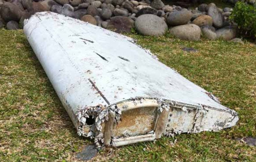
Last year, in a massive crowdsourcing effort, eight million volunteers from around the world sat at their computers and searched high-resolution satellite imagery looking for signs of Malaysia flight 370, which had left Kuala Lumpur and never arrived in Beijing. The effort was akin to putting thousands of digital helicopters into the sky above 340,000 square kilometers of ocean. The project, organized by DigitalGlobe’s Tomnod group, didn’t find evidence of the plane. More than a year later and with wreckage recently discovered, it’s a good time to do a post-mortem of the crowdsourcing effort that involved amateur GPS citizen scientists from around the world.
Tomnod provided volunteers with images of the Thailand Gulf, Andaman Sea and areas of the Indian Ocean (West of Australia), an area that had been recommended for scrutiny by AMSA, the Australian Maritime Safety Authority. The area was organized by map tiles, each one-eighth of a kilometer. The images provided to the volunteers were still photos, a snapshot in time. The search followed the core rule of crowd sourcing — redundancy, and all map tiles were reviewed by multitudes of people.
The Tomnod crowdsourcing website from 2014.
I signed up to search images, and like others, was instructed to individually tag signs of wreckage, rafts, oil spills and interesting objects. Volunteers submitted 18 million tags for further review. Some of the tags were then inspected by analysts at Tomnod, but the vast majority were analyzed by computer programs alone. Search and rescue organizations were given the results to aid their search efforts.
With advancements in object recognition, one would think it possible for the initial search to be done by computer vision algorithms. Crowdsourcing could be used to manually clarify or further refine classifications. Tomnod believes identifying objects in the ocean is difficult and best done by humans, but has used digital object recognition in a new project. “For our project of mapping Swaziland to help eliminate malaria, Tomnod uses object recognition algorithms to locate buildings,” says Caitlyn Milton of DigitalGlobe. “Our next step is having crowdsource volunteers manually draw building footprints for each individual building. We either use volunteers or deploy our algorithm to identify the roof types (metal, wood or thatch), which are correlated with Malaria rates.”
Debris from flight MH370 washed up on Réunion Island in July.
Tomnod would have needed a trifecta: the correct geographic area, visible debris and identification of the debris to yield the actual crash site. Unfortunately, even with the discovery of plane parts found last month near Réunion Island in the Indian Ocean and even with analysis of ocean currents and weather conditions, it will be difficult to ascertain if the plane crashed within the Tomnod search area.
Crowdsourcing is not new to mapping. European countries offered hefty pouches of gold in the 1500s to people who could help solve the puzzle of determining latitude for maritime navigation. The competitors were well educated — mathematicians, astronomers and watchmakers. To contribute today, all one needs is a computer, a wireless connection and free time.
Next month, I’ll be in Las Vegas at CTIA’s Super Mobility 2015 reporting on industry developments. If you have interesting news, contact me.
One of the marvels of the decade is crowdsourcing. This month I look at crowdsourcing for indoor-location positioning and report findings on GPS in smartphones that provide reliable earthquake warnings. Google has had some issues with mapping crowdsourcing, leading to the temporary suspension of Map Maker. If Google can’t block inappropriate content, it does give pause.
Next, I look at connected cars. Since this fall, four out of nearly 50 self-driving cars driving throughout California have gotten into accidents. With connected vehicles about to start popping out of dealerships, the legality of hands-free driving is belatedly being examined. And, last, INRIX has released an analytics platform that will use the massive data coming from connected vehicles.
Crowdsourcing Indoors. Crowdsourcing has worked for mapping, but what about for indoor location? Sensewhere thinks it can work. The company’s indoor positioning technology learns Wi-Fi mapping through crowdsourcing. The premise is that it gets better over time, with each user’s device adding to the Sensewhere database. For instance, Sensewhere’s ability to determine the location of an office door from the building’s lobby will improve with each trip down the corridor. Although other systems may be more accurate, Sensewhere requires no infrastructure. The company claims accuracy of 10 meters or better.
Sensewhere’s solution doesn’t require the Wi-Fi mapping labor that companies like Skyhook initially undertook. Skyhook engaged in “wardriving,” a peculiar term defined by Wikipedia as “the act of searching for Wi-Fi wireless networks by a person in a moving vehicle, using a portable computer, smartphone or personal digital assistant (PDA).” The term “wardriving” originated from “wardialing,” popularized by the 1983 film War Games in which the lead character, played by Matthew Broderick, has his computer automatically dial phone numbers in search of modems, perhaps the precursor to robocalling.
Crowdsourcing for Earthquakes? The GPS in smartphones can detect the earliest signs of a quake with at least a magnitude of 7. The challenge is to distinguish an earthquake from the usual bouncing and jarring every cell phone encounters. Scientists at the U.S. Geological Survey found that if 103 phones in a defined vicinity record the same displacement, there is an overwhelming likelihood that a quake is occurring. The amount of forewarning is very small and maybe only a few seconds, but it could be enough time for a surgeon to retract a scalpel or a person to take cover.
Is Automated Hands-Free Driving Legal? Given the batch of vehicles with automated driving about to land this year and next, you’d think that the answer would be a resounding yes. But it isn’t clear. Only one state, New York, requires drivers to have one hand on the wheel at all times. The law was enacted in 1967 without the impetus of connected vehicles. A handful of states have legalized automated driving in certain instances. It would be more practical for the federal government to step in to avoid a patchwork of regulation. The automotive industry and other boosters would argue that if automated driving isn’t specifically prohibited, it is legal. However, “drivers” of automated vehicles could find themselves ticketed by police, who could deem hands-free driving as “reckless driving.”
Tapping Big Data from Connected Vehicles. Where you go in your car and what you do in it will be used by INRIX in its new Insights analytics platform. Over the years, INRIX has transformed itself from a purveyor of traffic data to a sophisticated driving and traffic analytics player. The platform will use data from connected vehicles for urban planning, retail site selection and advertising usage, leveraging real-time GPS from a network of 250 million vehicles and devices. INRIX introduced InsightsTrips, a data-as-a-service application for understanding population movement across a metropolitan area. InsightsVolume provides information on how many vehicles typically pass a location.
Android Mascot Defacing Apple’s Logo. Not even Google is impervious to spam attacks and obscene edits. Google has temporarily disabled its crowdsourcing map editing tool, Map Maker. The tool, especially important in countries that lack detailed maps, allows maps to be updated with new geographical features and roads. In April, Google improved its spam detection system in response to escalating hacking, but the company’s efforts were not enough. One recent misdeed was the renaming of a business located near the White House to “Edwards Snow Den,” a play on Edward Snowden. However, the prank that seemed to precipitate Google taking Map Maker offline was an image of the Android mascot urinating on an Apple logo that appeared on a map.
The Android mascot could have used the crowdsourced app Sit or Squat to find a more appropriate venue. Crowdsourcing knows few boundaries.
In response to the devastating 7.8-magnitude earthquake that struck central Nepal on April 25, DigitalGlobe has made high-resolution satellite imagery of the affected areas freely available online to all groups involved in the response and recovery effort through the company’s FirstLook initiative.
The below before and after images show the destruction of the nine-storey Dharahara Tower, which was built in 1832 and was a UNESCO World Heritage site.
The Dharahara Tower in Kathmandu, in a DigitalGlobe satellite image taken in October 2014. (Image credit: DigitalGlobe)The Dharahara Tower is shown leveled following the earthquake (Image credit: DigitalGlobe).
Specifically, DigitalGlobe activated FirstLook, the subscription service that provides emergency management and humanitarian workers with fast, web-based access to pre- and post-event images of the impacted area. DigitalGlobe captured imagery of the area April 26 through heavy cloud cover with its WorldView-1, and WorldView-3 and GeoEye-1 satellites. WorldView-2 and WorldView-3 have been tasked to image the area again April 28. Pre-event imagery dating back to April 1 is also available to aid understanding and coordination for on-the-ground missions.
In addition, DigitalGlobe has activated Tomnod, the crowdsourcing platform that allows web-connected volunteers around the globe to help disaster response teams by mapping damage from this earthquake. While satellite imagery on its own is useful, greater benefit comes from extracting meaningful information that can be used by first responder and recovery agencies.
By visiting the Tomnod website, users can participate in the Nepal campaign by tagging damaged buildings, roads, and areas of major destruction to inform disaster response teams on the ground. Whether a person donates five minutes or five hours, anyone can analyze DigitalGlobe imagery to help make a difference.
Screenshot of the Tennessee Law Enforcement Facility Mapping Challenge showing the more than 440 edited points (green dots). At this scale, many dots contain more than one edited or verified structure.
Volunteer mappers continue to make contributions to ability of the U.S. Geological Survey (USGS) to provide accurate mapping information to the public. Recently, volunteers were asked to update all of the law enforcement structure points in Tennessee. The volunteers answered the call and added, verified, edited or deleted 440 points.
All of the points were quality checked by either a peer reviewer or an advanced editor, so the data was ready to go into the National Geospatial Program’s web-based The National Map at the conclusion of the USGS Mapping Challenge.
The volunteer additions and edits will be symbolized on US Topo maps during the next production cycle for Tennessee, slated for 2016.
Mapping Challenges, conducted by the National Map Corps, ask volunteers to concentrate on specific areas and structure types that need updating. They encourage volunteers to remain engaged and incentivize participation. Once a need is determined, a call to action goes out to the volunteer corps with information on the geographic location and the type of structures that need updating. Volunteers who participate can earn a series of virtual recognition badges and are recognized on social media and the Map Corps project site.
Using crowd-sourcing techniques, the National Map Corps encourages volunteers to collect manmade structures data in an effort to provide accurate and authoritative spatial map data for The National Map. Structures being updated include schools, hospitals, post offices, police stations and other important public buildings.
“At times, locating structures seems similar to solving puzzles or detective work,” commented fconely, a Challenge veteran and one of the project’s more active participants.
This year’s Mobile World Congress in Barcelona was the biggest ever, with 95,000 attendees and thousands of booths, conferences and people with sore feet walking a cavernous exhibition hall. While the Geneva Auto Show ran close to the same dates, connected vehicle companies and technology were prominently featured. What was interesting, however, was the rise of indoor positioning companies and mobile advertising agencies with interest in location.
BARCELONA — Joining the 95,000 or so Mobile World Congress attendees were about three dozen companies who are offering indoor location and location advertising services. These companies have exhibited at previous conferences, but not in the numbers this year.
At the huge Fira convention center where MWC was held March 2-5, Los Altos, Calif.-based Pole Star installed more than 600 beacons for indoor location. Visitors were able to be guided to booths and other areas through an interactive map. “Business was good in 2014, we sold 10,000 beacons. We are making money,” said Christian Carle, Pole Star CEO.
One analyst said that the big change at MWC wasn’t the number of indoor positioning companies and demos, but the maturity and breadth of the technology. “Intel announced indoor positioning capabilities in their Wi-Fi chip, and had a demo that was very impressive. Many smaller companies that in past years were showing raw technology were showing polished solutions this year, such as Quuppa, MTI and Sensewhere, said Bruce Krulwich, Grizzly Analytics president, who has authored a report identifying 150 indoor positioning companies. “I definitely see a shake-out coming up, but it won’t be one technology prevailing over another. Different technologies meet different needs in the industry, and different technologies fit different sites. There are technologies that deliver universal indoor positioning, without any infrastructure or preparation, such as Wi-Fi multilateration and sensor fusion.”
Krulwich said that there is a shake-out that’s already started because there are too many companies working on similar technologies. “Start-ups in the area that don’t have differentiating innovation, don’t have integration into retail or other back-end systems, and don’t have market penetration, are already finding themselves in a challenge. But companies with clear innovations and commercial deployments will do fine,” he said.
United Kingdom-based Sensewhere is using crowdsourcing in its indoor positioning software. The software uses radios to scan for Wi-Fi and Bluetooth to allow an IP location to reference the sources and form a location database.
“It’s what we call the universal indoor positioning versus venue specific indoor positioning, which can work anywhere — we just need a crowd of people. Our target partners are handset manufacturers, network operators, social media, social network providers, and also chipset guys as well,” said Rob Palfreyman, Sensewhere CEO. “So, there are obviously a lot of companies like Google looking at venues; there is Micello and TomTom looking at add-ins in the indoor location, which is great news, but it just needs to have a technology that can drive the blue dot on their map, and we feel that Sensewhere is the right place to provide that blue dot because of the crowdsourcing global nature of our approach.”
One company, which has developed a popular mobile game, is using its network to attract advertisers for its location-based ad platform. “We already have the infrastructure in place because of our mobile game. With our platform, we can allow advertisers to launch campaigns using our beacon signals and geofencing,” said Pedro Jahara, CEO of Brazil-based RevMob.
New location technology like the ability to track SIM cards was rolled out at MWC. W-Locate, which is partnering with Morpho in Thailand, is tracking SIM cards with its XimLoc product, which the company said is more accurate indoors than other technology.
Even such companies as Geotab, which is a strong player in the fleet market, are leveraging MWC to continue a foothold in the European market. The company displayed its IOX-CAN system that can send data from a mobile device to the MyGeotab system, which can be viewed an analyzed by fleet managers, said Maria Sotra, Geotab marketing manager.
Geotab also partnered with Telefonica in November 2014 to focus efforts in Spain, Germany and the United Kingdom, Sotra said.
At MWC, location-based advertising market is gaining traction as advertisers are seeing the benefit of locating and attracting customers. New York-based xAd said it has doubled its revenue for the second year. “We have billions of mobile ads processed and billions of ad impressions. The company is profitable,” said Dipanshu Sharma, xAd founder and CEO.
He said the company has expanded into France and Germany and added China to its global ad network.
Another company that is using location technology as a differentiator is Airpush, which had another big presence at MWC. The company’s Abstract Banners was a big draw to attendees. Location, particularly geofenced areas, have created a call to action for consumers, which is attractive to advertisers, said Cameron Peeples, Airpush vice president of marketing.
Connected Car Still Big Opportunity at MWC
Although the Geneva Auto Show was starting as the MWC was ending, there were still several big announcements by connected car companies in Barcelona. Even the well-publicized Samsung S6 and S6 Edge and HTC One M9 handset rollouts included Mirrorlink, the connected vehicle standard from the Connected Car Consortium.
In another big announcement, Audi and AT&T said that all 2016 model vehicles equipped with Audi connect will come with the carrier’s 4G LTE or 3G coverage. This increase in services is big because the auto giant just rolled out 4G AT&T service in Audi A3s last year.
AT&T selected Airbiquity to provide end-user registration and device management connected vehicle services for select customer programs. “Airbiquity will deliver these services to AT&T using our Choreo cloud-based connected vehicle services delivery platform and project management, engineering, and operations teams,” said David Jumpa, Airbiquity chief revenue officer. “This is a ‘white label’ agreement whereby AT&T will integrate Airbiquity’s service delivery capability into AT&T’s connected vehicle customer solutions.”
Another location company is making huge inroads in connected vehicle markets with its Glympse for Autos product. Glympse will be installed in select Volkswagen and Peugeot models through MirrorLink, said Bryan Trussel, company co-founder and CEO.
The app allows users to share location from their vehicle by setting the recipient and timer, and hitting send. The company has a similar app for Gogo inflight aviation networks to allow a person on the ground to know where an airplane is for picking up passengers.
In other connected car news, Accenture is providing Fiat Chrysler Automobiles the capability of in-car, Internet-based services. Starting with the new Fiat 500X, Uconnect Live services, which was co-developed by Accenture, will power an infotainment system that offers music and news services, social network access, the ability to monitor driving style and a range of diagnostic services.
Accenture also partnered with Visa for an IoT-based connected car commerce test. At MWC, the company tested a scenario where drivers could order food from the car using cellular, Bluetooth and beacon connectivity. Accenture deployed a similar system with BMW’s ConnectedDrive, which allows customers to choose services in real time for a vehicle.
Health Market Even Has Location Potential
Niche location applications are growing as Internet of Things, or IoT, markets start to grow. One company taking advantage of the mobile market is Annapolis, Md.-based TCS, which featured its VirtuMedix platform in its MWC booth.
The platform is tailored to emergency physicians as part of the growing market for video telemedicine products and mobile health, said Jay Whitehurst, TCS commercial software group president. “It’s already saving lives,” he said of the platform, which combines encryption, navigation, mapping and messaging.
While the product, now being rolled out in a North Carolina emergency medicine group, provides patients with an alternative to urgent care centers and emergency rooms, it also can be used for longer term cases such as assisted living and rehab centers, the company said.
Whitehurst said TCS has made several company acquisitions that have played a part in new product rollouts, which include the company’s Trusted Location. The application allows financial firms, online gaming companies and others to identify and prevent credit-card fraud. The application identifies and validates a device’s location worldwide.
In other Mobile World Congress news:
Spirent said its simulators have the capability to evaluate Wi-Fi Offload and Wi-Fi performance of mobile devices on its test framework. The new product allows companies to test multiple devices on a single unit to cover Wi-Fi/LTE mobility and interoperability. The testing is important in light of wireless carriers’ strategy to extend VoLTE in areas where cell coverage is limited, said Saul Einbinder, Spirent vice president, venture development.
Google Waze said its Google Mobile Service (GMS) will be available as a preinstall option on mobile devices. OEMs and carriers can preinstall the app on their handsets so consumers can use the service immediately, the company said.
Trimble’s ALK said its ALK Maps and route visualization software is now available in Europe. ALK Maps, launched in the United States in 2012, allows users to overlay routing, geocoding points, weather and other features, the company said.
Editor’s note: Dennehy is GPS World’s editor for location-based services, writing a monthly column for the LBS Insider newsletter. The views expressed are his own. He will be covering the Mobile World Congress in Barcelona for GPS World. Contact him at [email protected] with your news.
Sen. Ed Markey’s new car technology report, released earlier this month, basically says that connected vehicles can be hacked, causing danger to drivers and presenting major privacy concerns. While some critics believe Markey’s report was meant to drive media hysteria, others say it raises serious issues that the industry needs to address. In other location news, I’ll be covering the Mobile World Congress in Barcelona for GPS World. What will be the showcased location technology? Wearables? Connected vehicles? Or something new?
Kevin Dennehy
By Kevin Dennehy
A report released by Sen. Edward Markey (D-Mass.) earlier this month says that even though drivers have come to rely on new connected technologies, automakers haven’t done their part to protect them from cyber attacks or privacy invasions
First reported by CBS News’ 60 Minutes, Markey’s report, Tracking & Hacking: Security & Privacy Gaps Put American Drivers at Risk, includes information from 16 automobile manufacturers who were given questions about security and privacy. However, few of the carmakers’ answers included how vehicles may be vulnerable to hackers — and what driver information is collected.
Location industry veteran Kim Fennell, deCarta CEO, said the report should be a real concern to the industry. “But it’s more of an issue for autonomous driving and the security of the car’s electronic control system. Even today, the OnStar service, which was a pioneer in the connected car space, can remotely slow your vehicle down in the event of a theft,” he said. “This feature, if hacked, could definitely create massive problems if the proper security technologies are not implemented.”
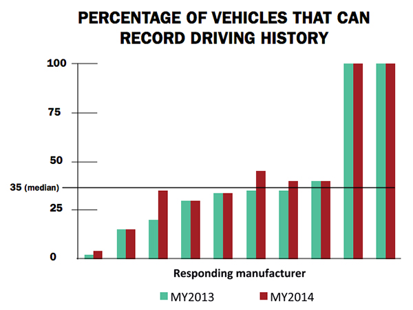
Markey’s report raised additional concerns about the use of navigation and other features that record and send location or driving history information.
Fennell said there should be a distinction between the infotainment systems in the vehicle and the on-board control systems of the car.
“We believe that there should be a strict firewall between these systems so that nothing malicious can happen that is initiated from the connected infotainment system. Any data should flow one way — from the control system of the car to the infotainment system,” he said. “This is not to say that the connected infotainment system shouldn’t be secure, it should be. In working with our OEM and Tier One partners, we have implemented strict security protocols between our servers and their apps.”
Markey’s report found that “[automakers] use personal vehicle data in various ways, often vaguely to ‘improve the customer experience’ and usually involving third parties, and retention policies — how long they store information about drivers — vary considerably among manufacturers.”
In addition, the report found that customers are often not made aware of data collection and, when they are, they often cannot opt out without disabling features, such as navigation.
Percentage of Vehicles that can record driving history
Overall, Fennell hopes that the most malicious thing that could happen in the event of a hack of an infotainment system is that a “Pandora station is changed to play nothing but Justin Bieber songs, the traffic information for your route is projected to be ridiculously long or the Yelp rating of the restaurant that you are going to is lowered down to one star.”
Ultimately though, the driver should be in control of the car and nothing in the infotainment system should affect the behavior of the vehicle, Fennell said.
In terms of driver safety, in a recent survey, deCarta found that more than two-thirds of respondents considered dashboard screens that display videos and other Internet content to be the most dangerous types of onboard information systems. Approximately 79 percent of those polled preferred “voice-activated mapping systems that allow drivers to keep their eyes on the road” as an essential safety-enhancing feature.
“There are two things that infotainment systems could do better to prevent driver distraction. First, instead of replicating the stove-piped app store environment of the smartphone, in-car infotainment services could be better integrated,” Fennell said. “If I find a destination on Yelp, I’d like to send that to my navigation system instead of typing in the address. Second, with today’s better automated speech-recognition technology and text-to-speech engines, it’s now possible to make requests of your infotainment system using natural language commands. Voicebox is doing some great things in this area.”
Fennell said that most existing systems are not connected. “But those that are, aren’t predictive enough. Your navigation/infotainment system should almost work as a concierge,” he said. “It should recognize what time it is and realize you are most likely leaving for work and offer up the best route based on traffic conditions. It should recognize that you are going to a destination in an urban area and offer the most convenient parking to your destination.”
Company Rolls out Indoor Positioning Product that Doesn’t Require Retailer Involvement
After testing and demoing the product in San Francisco last year, IndoorAtlas is rolling out a consumer app called GPSindoor, which uses smartphones to locate shoppers inside a mall. The product features product proximity advertising to allow shoppers to see where they are relative to a product for promotion marketing.
The product includes a crowdsourcing function to allow user-generated data to build indoor maps, wayfinding and other options for shopping promotions, said Wibe Wagemans, IndoorAtlas president.
“We don’t need any retailers per se. We need only the shopper and [their] smartphone,” he said. “There is no brand or retailer involvement if you use our app. Unlike Wi-Fi and Bluetooth beacons, since GPSindoor relies on a community of shoppers, it allows for higher accuracy than static maps. That gives us the confidence to take on the giants like Apple Beacons and Google Indoor Maps head on — we are completely independent of retailers and not dependent on them for our success in becoming the GPS of indoors.”
In other location news:
HERE released a new version of its mapping system for Android, saying it made significant improvements. According to the company’s blog, after more than 3 million downloads, it is shedding the “beta” label with this version. In the beta version, when users asked for a route, the app gave them three car routes. If a user wanted public transit or pedestrian routes, they had to switch to the appropriate tab. This process was slow and inconvenient for people who don’t use a car all the time, HERE said.
In its recent financial statements, Garmin indicated a growing, and profitable, segment is its wearables/fitness band product line. Mio is also expanding its wearable offerings. This should be a big topic at next months’ Mobile World Congress.
I’ll be covering the Mobile World Congress in Barcelona for GPS World. Contact me at [email protected] with your news.
The U.S. Geological Survey citizen science project, The National Map Corps, has realized remarkable response. In less than two years, the volunteer-based project has harvested more than 100,000 “points.” Hundreds of volunteer cartographers are making significant additions to the USGS ability to provide accurate mapping information to the public.
Each point represents a structure or manmade feature on a map that has been verified and updated, and then submitted to support The National Map and US Topo maps.
Using crowd-sourcing techniques, the USGS Volunteer Geographic Information project known as The National Map Corps (TNMCorps) encourages citizen volunteers to collect manmade structure data in an effort to provide accurate and authoritative spatial map data for the USGS National Geospatial Program’s web-based map products.
“I am 80 years old. I work three days a week for a golf course trapping moles and gophers,” said a prominent citizen scientist volunteer who goes by the handle Mole Trapper. “I spent 11 years volunteering for a fish and wildlife agency. When the big landslide at Oso, Washington, happened, I went on the USGS website and discovered the map corps. I worked summers while in high school for a surveyor who was very precise, and he told me an inaccurate survey is worthless. I hate inaccurate maps, so this program was just right for me. I hope my work is as accurate as it can be, but if it isn’t, I plead old age.”
Structures being updated include schools, hospitals, post offices, police stations and other important public buildings. The data being collected by volunteers becomes part of The National Map structures dataset, which is made available to users free of charge.
“I am retired from an unrelated field, but I have loved maps and travel all my life,” explained another active volunteer who goes by fconley. “When I saw that USGS was looking for volunteers, I immediately joined, first working with paper maps and quads. As digital mapping, satellite imagery, and GPS became more available I was enthralled. With the imagery now accessible, it is almost like being able to travel sitting at my desk. At times, locating structures seems similar to solving puzzles or detective work. This whole project is not only enjoyable,it makes me feel that I am making a lasting and useful contribution. I am thankful for the opportunity to be involved in this fascinating endeavor.”
Beginning as a series of pilot projects in 2011, The National Map Corps has grown state by state to include the entire U.S. By August 2013, volunteers were editing in every state in the country and the U.S. territories. To date, the number of active volunteers has grown to 930, including some participants who have collected in excess of 6,000 points.
To show appreciation of the volunteers’ efforts, The National Map Corps instituted a recognition program that awards “virtual” badges to volunteers. Each edit submitted is worth one point towards the badge level. The badges consist of a series of antique surveying instruments and images following the evolution of land survey and moving to aerial observation of the Earth’s surface, such as pigeon-mounted cameras and hot-air balloons. Additionally, volunteers are publicly acknowledged (with permission) via Twitter, Facebook and Google+.
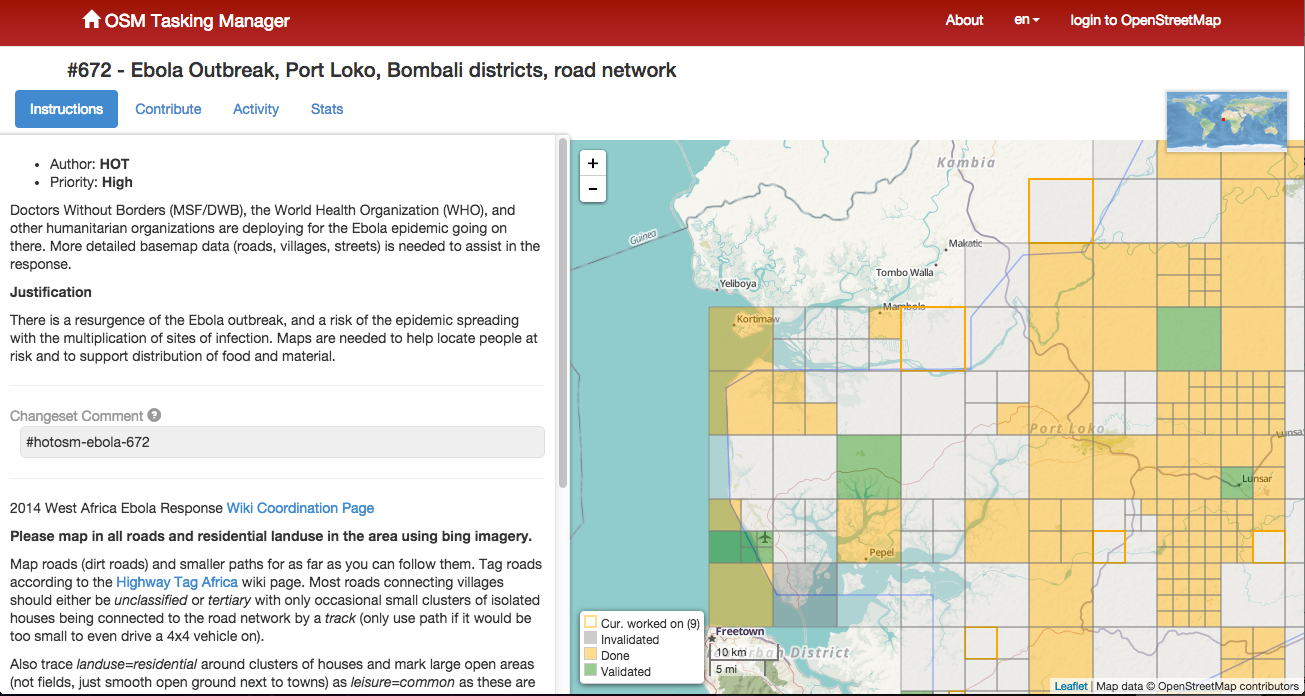
The American Red Cross Geographic Information System team is enlisting volunteers to help map areas in Africa hard hit by the ebola virus. The Red Cross is attempting to get ahead of the virus by creating detailed maps of rural towns and villages so officials can track the deadly virus as it spreads, according to ABC News. Volunteers have been drafted to study satellite imagery of homes, schools and villages.
Once the maps are detailed, they are sent to Red Cross partners, including Doctors Without Borders and the International Federation of the Red Cross and Red Crescent, which are working in the field to treat victims and stop the outbreak.
The maps are useful in a variety of ways. With better maps, epidemiologists can track where the disease is spreading, and find sick individuals in remote areas. In a specific example, the World Health Organization requested that GIS professionals look at cemeteries, a key location where infection can occur.
The volunteers have been able to fine-tune maps of remote villages which are used by relief workers trying to navigate rural roads, towns and neighborhoods. For instance, the original map for Guéckédou, Guinea, a town near the epicenter of the outbreak, showed just nine roads. After volunteers studied satellite photographs, they were able to add hundreds of roads and streams.
The project goes both ways, as people working in the remote areas send in GPS locations for villages that have never been mapped before. The maps can be vital to fight Ebola in rural areas where road signs, maps and GPS locations are scarce.
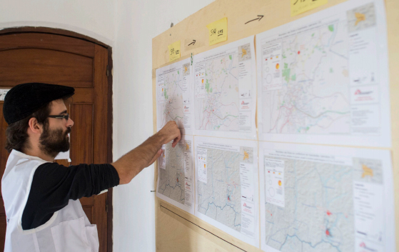
A GIS expert helps the Doctors without Borders epidemiological team respond to the ebola outbreak. Photo: American Red Cross Geographic Information System
The effort is similar to an effort by MSF-Switzerland (Doctors without Borders) in March 2014, which deployed a dedicated GIS officer to Guinea in response to the Ebola outbreak in the south of the country. During his eight-week his mission, the GIS officer produced 109 maps for this previously very poorly mapped area. The maps included basic orientation maps that showed roads, landmarks and villages but also specialized maps that visualized population density or the spread of the disease.
With the help of the newly created database and subsequently produced maps, the GIS officer was able to pinpoint the exact location of villages and identify villages that had the same name but were in different parts of the prefecture. Based on this information, MSF program staff were able to respond to the outbreak faster, in a more targeted way and with fewer resources.
Plus, the weekly mapping of confirmed and suspected Ebola cases helped translate the progression of the epidemic from technical data into an easy-to-grasp map. As a result, staff at all levels had a better understanding of the emergency.
Just like the American Red Cross is currently doing, the GIS unit crowdsourced certain mapping tasks, which resulted in a substantial number of overview maps created with the help of close to 250 online volunteers. The volunteers helped to map previously unmapped cities and roads within a few days, and at a granular level, mapping individual buildings. These overview maps then became the foundation of many maps that the GIS officer created for the outbreak response.
To learn more about that project, download a PDF report, “GIS Support for the MSF Ebola response in Guinea in 2014.”
For historical context, Esri’s ArcGIS is provides a story map that shows previous ebola outbreaks in Central Africa, 1976–2013, as well as the current outbreak. The interactive story map explores the first known contact with the disease in 1976 in the Democratic Republic of Congo and every outbreak since then, including the ongoing crises in Guinea, Liberia, Sierra Leone, and Nigeria. Users get basic statistics about each outbreak and browse reports from different agencies, all directly within the map.
Status map showing the location and density of volunteer submitted structure edits.
This April marks the one year anniversary of the transition of the USGS’s The National Map Corps (TNMCorps) from a small regional pilot project in the heart of Denver, Colorado, into a successful nationwide project. During the past year, civilian volunteers in every state have increasingly provided accurate mapping data to the National Geospatial Program’s publicly available application called The National Map.
Using crowdsourcing techniques, TNMCorps’ Volunteered Geographic Information (VGI) project engages citizen scientists to collect man-made structures data including schools, hospitals, post offices, police stations and other important public buildings.
Over the past year TNMCorps has achieved the following significant milestones:
1,422 – volunteers
42,009 – contributions (counts each person’s edit per single point)
50,696 – total number of edits (the sum of all edits made by volunteers)
50 – number of states involved
18 – number of volunteers who have earned more than 500 points
4,691 – state with largest number of edited points; Colorado
“This project has proven that we can count on volunteers to provide quality information to be included in authoritative government databases,” said Kari Craun, director of the National Geospatial Technical Operations Center. “The people that have contributed their time are performing a community service by ensuring key structures data are available publicly.”
To volunteer, go to The National Map Corpsproject site. The project is seeking anyone with access to the Internet willing to dedicate some time editing map data. Participants can earn badges and public recognition by a series of points.
While some familiarity with the area that a volunteer chooses is helpful, volunteers don’t have to live near a particular place to contribute. The tools on TNMCorps website, along with ancillary information available on the Internet, are generally sufficient to edit a distant area.