To mark the one-year anniversary of the PNT Executive Order, Orolia will host an interactive Coffee Talk webinar on March 24 to explore the latest developments in the national initiative to protect U.S. critical infrastructure from GPS/GNSS jamming, spoofing and interference.
Panelists from the U.S. Department of Homeland Security (DHS) and the National Institute of Standards and Technology (NIST), among others, will focus on key actions and priorities for 2021 and beyond, including insights and context on recently published works such as the NIST Foundational PNT Profile issued on Feb. 11, 2021, and the DHS Conformance Framework of Dec. 18, 2020.
Critical infrastructure and PNT industry panelists will also share their perspectives on practical ways to increase resiliency and key factors to consider, in view of the latest Executive Order guidance.
More information about Resilient PNT and GNSS jamming/spoofing is available in Orolia’s online resource center.
Panelists include:
Ernest Wong, Technical Manager, Science and Technology Directorate, DHS
Jim McCarthy, Senior Security Engineer, National CyberSecurity Center of Excellence, NIST
Register here for the Coffee Talk “PNT Executive Order Update: 2021 Actions and Priorities,” 11 a.m. EDT, March 24. Use the registration form to share questions or comments on what to discuss.
A new paper by two Qualcomm engineers imagines restructuring Loran technology to more easily incorporate timing signals into telecommunication systems.
The paper, titled simply “LORAN-5G,” was authored by Guttorm Opshaug and Dave Tuck. It envisions moving away from legacy pulsed signals to a more continuous wave form which would allow significantly lower power transmissions.
According to Opshaug, “Another big advantage that may not be as apparent, is the built-in orthogonality in the signal structure of OFDM. This means that a receiver would be able to detect very weak signals from distant towers at the same time as receiving signals from a very strong close tower. Such robustness towards near-far effects is critical for terrestrial navigation use.”
Another change would be a marked increase in the capacity of the Loran data channel to more than 2.6kbps. “This could open opportunities for additional service options and/or reduce latency of existing ones,” according to Tuck.
UrsaNav CEO, Charles Schue, expressed great interest in Qualcomm’s paper. UrsaNav is a long-time provider of Loran equipment and consulting. “The intersection of PNT and communications discussed in the Qualcomm paper is exactly what is needed to ensure that PNT systems evolve and stay relevant,” he said. “In fact, we build our software defined transmitter and receiver solutions to specifically include the ability to produce and use these types of signals.” A Cooperative Research and Development Agreement between UrsaNav and the Department of Homeland Security demonstrated these type of potential upgrades in 2012.
This paper is the first publicly released effort examining the use of Loran technology to support 5G telecommunications. The general concept was discussed in a 2016 paper by the Alliance for Telecommunications Industry Solutions’ (ATIS) Synchronization Committee. Based on the paper, ATIS in 2017 encouraged members of Congress to pass legislation that would become the National Timing Resilience and Security Act of 2018 (NTRSA).
There are tradeoffs. Opshaug and Tuck’s proposal would replace the legacy Loran standard signal with a new one.
“I was in the midst of developing proposals for the 3GPP standards organization when I first heard about the NTRSA,” said Opshaug. “5G seemed like exactly the kind of critical infrastructure that could benefit from a backup timing solution.”
“We wanted to bring some of the ideas used to develop 5G position and timing to Loran,” said Tuck. “Using Loran as the timing synch could enable 5G to improve overall infrastructure resilience.”
Yet, as with most things, there are tradeoffs. Opshaug and Tuck’s proposal would replace the legacy Loran standard signal with a new one. This would require redesign of receivers and some transmitters. The proposal could support denser deployments to further improve resiliency.
“The new signals seem incompatible with existing receivers and Loran networks,” according to Professor Jiwon Seo of South Korea’s Yonsei University. South Korea is upgrading its Loran-C network to the eLoran standard. The new South Korean system will be compatible with neighboring Russian and Chinese Loran systems, so users will be able to benefit from signals anywhere in East Asia. Until 2010 signals from the U.S. Loran system cooperated with these networks as part of the Far East Radionavigation Service (FERNS).
Navigation expert Logan Scott is intrigued by the proposal but observes that more work needs to be done. “This is an interesting waveform,” he said, though he had questions about the propagation channel, antennas, and possible distortion.
The authors acknowledge that much more needs to be done, including better determining timing and positioning accuracy.
Yet they and others see potential in combining the very different phenomenologies of low frequency, 100KHz Loran and 5G telecommunications which typically operate in the gigahertz range.
Opshaug and Tuck’s paper LORAN-5G can be accessed here.
The U.S. Department of Homeland Security “did exactly what was required by Congress” in issuing its report in June on positioning, navigation and timing (PNT), according to a letter sent by numerous PNT companies to the DHS.
The July 17 letter to Chad F. Wolf, acting secretary of Homeland Security, refutes a previous letter from Congressional representatives that the report contained numerous errors and failed to address many of the things Congress had required.
“We believe that some key claims made in the members’ letter of June 9 are either exaggerated, irrelevant to the report’s Congressional tasking, or simply wrong,” states the July 17 letter, which is signed by senior executives of Satelles, Orolia, Iridium, Navsys, Jackson Labs, Seven Solutions and Qulsar.
The group takes on the claims of the representatives point by point, finding them exaggerated, irrelevant or incorrect.
For instance, the letter critical of the DHS report states:
“The report focuses on the needs of ‘industry’ largely ignoring the needs and impacts on public services (including first responders), government operations, and individual citizens.”
In response, the industry representatives state:
“The focus of the report, as directed by the NDAA, is on the requirements of the owners and operators of national critical infrastructure. This includes “public services, government operations,” and its beneficiaries, “individual citizens.” To the extent that the report focuses on incentivizing the industry, it is in order for it to be able to meet these requirements.
“While the report only highlights PNT use cases from a subset of the 16 critical infrastructure sectors, their pragmatic recommendations address a range of requirements across all sectors. With respect to PNT needs for backing up GPS, DHS acknowledges the differences between and commonalities among the sectors and offers exceptional guidance for leveraging the capabilities of diverse forms of commercially available alternative PNT rather than endorsing a single, anti-competitive, government-imposed solution.”
Not just supporting players, alternative positioning, navigation and timing (PNT) systems strengthen, augment and — when needed — replace GNSS. We explore how companies are using alternative PNT, and talk with John Fischer of Orolia and Alexis Guinamard of SBG Systems about their companies’ latest developments.
Since the 1990s, GPS has provided the United States military with a substantial tactical edge. Civilian GPS applications are now deeply embedded in every aspect of our lives. The U.S. Department of Transportation recently reaffirmed that GPS’ positioning, navigation, and timing (PNT) services are critical to the safe and efficient use of the national transportation system, and a Feb. 12 presidential executive order declared that satellite-based PNT services “have become a largely invisible utility for technology and infrastructure.”
It has long been equally well known, however, that GPS is vulnerable to accidental and intentional interference (the latter known as jamming), spoofing, and degradation or denial of signals. Additionally, GPS satellites are increasingly vulnerable to damage or destruction by space debris or intentional attack. The executive order mentioned above declared it U.S. policy “to ensure that disruption or manipulation of PNT services does not undermine the reliable and efficient functioning of [the country’s] critical infrastructure.”
Protecting PNT requires not just strengthening GPS, but also developing alternative sources of PNT data and ways to integrate them into the myriad systems that currently rely on GPS.
The National Timing Resilience and Security Act of 2018 (passed by the U.S. Senate as part of that year’s Coast Guard authorization act), called for “a complement to and backup for” the GPS timing component “to ensure the availability of uncorrupted and non-degraded timing signals for military and civilian users in the event that GPS timing signals are corrupted, degraded, unreliable or otherwise unavailable.” It mandated the procurement of a wireless, terrestrial system that would provide wide-area coverage and be synchronized with UTC, resilient and extremely difficult to disrupt or degrade, able to penetrate underground and inside buildings, and capable of deployment to remote locations.
A report released on April 8 by the Department of Homeland Security (DHS), however, recommends “that responsibility for mitigating temporary GPS outages be the responsibility of the individual user and not the responsibility of the federal government.” It points out that research by one of DHS’ agencies “shows that users can mitigate short-term GPS disruptions (e.g., inability to read a GPS signal) with various strategies, ranging from using local backup capabilities to delaying operations until GPS is restored.” The report then focuses on “mitigation against long-term or permanent disruption or loss of GPS PNT capabilities.” It determines that the PNT functions in critical infrastructure “are so diverse that no single PNT system, including GPS, can fulfill all user requirements and applications” and notes that maximum resilience is found in diversity of solutions. Therefore, it recommends that the federal government “encourage adoption of multiple PNT sources [to expand] the availability of PNT services based on market drivers.”
In the interviews below, I discussed these challenges with John Fischer, vice president of Advanced R&D at Orolia, and Alexis Guinamard, chief technical officer of SBG Systems.
U.S. Department of Homeland Security’s live-sky testing evaluations influenced development of BlueSky GNSS Firewall Software Release 2.0
Microchip Technology Inc. has released a major software update for its BlueSky GNSS Firewall product, providing a higher level of resiliency against GPS vulnerabilities for systems dependent on GPS signal reception.
Such systems include critical infrastructure such as power utilities, financial services, mobile networks and transportation that rely on GPS-delivered timing to ensure ongoing operations.
Microchip’s BlueSky GNSS Firewall Software Release 2.0 performs real-time analysis to detect jamming and spoofing for protecting reception of the GPS signal and hardening response and recovery to avoid signal disruption.
Release 2.0 includes charting and advanced threshold settings of GNSS observables such as satellites-in-view, carrier-to-noise, position dispersion, phase time deviation and radio frequency (RF) power level to simplify system turn-up and deployment.
The release also includes improvements developed by Microchip as a result of participation in a 2019 industry live-sky testing event hosted by the U.S. Department of Homeland Security (DHS) Science and Technology Directorate.
Microchip’s participation in the DHS-hosted GPS Testing for Critical Infrastructure (GET-CI) events included scenarios with spoofed signals, and helped the company identify new solutions to prevent signal disruptions. As a result, Microchip developed the Release 2.0 to address operators’ evolving requirements.
As a leader in frequency and time systems, Microchip continuously innovates GPS signal reception security technologies for commercial and military operators similar to how network firewalls protect against virus threats. Updates are essential to defend against rapidly-evolving GNSS disruptions and enable critical infrastructure operators to avoid interruptions of service.
When connected to Microchip’s TimePictra management software, critical infrastructure operators can monitor and analyze GNSS signals in cities, across geographic regions, throughout a country and even globally.
Other complementary devices and software in Microchip’s suite of GPS systems and services include the TimeProvider 4100 Precise Timing Grandmaster with Gateway Clock, SyncServer 600/650 timing and frequency instrument, miniature atomic clock (MAC), Time Cesium and 5071A cesium primary frequency standard.
The U.S. Department of Homeland Security (DHS) issued a report on alternative sources of PNT on May 6. It was submitted to U.S. congressional committee leaders on April 8.
Section 1618 of the 2017 National Defense Authorization Act (NDAA) of Dec. 23, 2016, required the DHS to address the need for a GPS backup by identifying and assessing viable alternate technologies and systems.
The report is a summary and analysis of that assessment by the Homeland Security Operational Analysis Center (HSOAC) of PNT systems currently used by critical infrastructure. It also provides recommendations for the federal government’s next steps to increase the resilience of critical infrastructure to disruption of GPS services.
In the report, DHS offers the following recommendations to address the nation’s PNT requirements and backup or complementary capability gaps:
Temporary GPS disruptions: End users should be responsible for mitigating temporary GPS disruptions. For example, the Federal Aviation Administration maintains sufficient PNT capabilities to assure the continued safe operation of the national airspace, albeit at a reduced capacity, during GPS disruptions. The federal government can facilitate this mitigation for various critical infrastructure sectors, but should not be solely responsible for it.
PNT Diversity and Segmentation: The federal government should encourage adoption of multiple PNT sources, thus expanding the availability of PNT services based on market drivers. Encouraging critical infrastructure owners and operators to adopt multiple PNT systems will diffuse the risk currently concentrated in wide-area PNT services such as GPS. Federal actions should focus on facilitating the availability and adoption of PNT sources in the open market.
System Design: PNT provisioning systems, assets, and services must be designed with inherent security and resilience features. Critical infrastructure systems that use PNT services must be designed to operate through interference and to identify and respond to anomalous PNT inputs. These attributes are applicable to the PNT receivers and the systems that use them.
Pursue Innovation that Emphasizes Transition and Adoption: Incorporating PNT signal diversity into the PNT ecosystem should be pursued with an emphasis on research and development that prioritizes successful transition and adoption into existing GPS receivers, taking into account factors such as business case considerations, financial costs, technical integration, and logistical deployment.
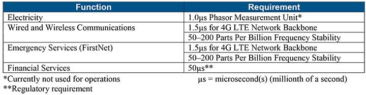
Table 1 shows timing requirements for critical infrastructure are, according to the report.
Table 1. (Image: DHS report)
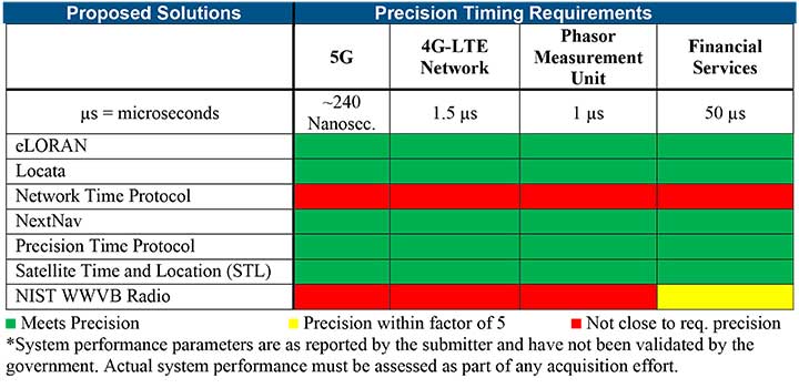
Table 2 from the report shows proposed timing solutions submitted by industry to DHS during a Request for Information (RFI) in December 2018. Systems that can meet or exceed timing requirements for critical infrastructure are indicated in green.
Table 2 (Image: DHS report)
Satelles responds
The Satelles company, which offers STL, issued a statement on the report. “This important report highlights the urgent need for GPS backup for critical applications, and it identifies and characterizes a variety of solutions that are available to meet this need today,” said Michael O’Connor, CEO of Satelles. “The report also describes the essential role of the federal government in urging industry to implement multiple technologies, without making the mistake of providing or selecting a single PNT solution.”
Continued O’Connor, “DHS goes on to define a baseline requirement for timing services accuracy for critical infrastructure. Not only does Satelles meet or exceed the precision timing specifications stated by DHS, but also our solution provides national coverage (including Alaska, Hawaii, and U.S. territories) and is commercially available now.”
Indoor location platform provides municipalities with emergency response and public safety solutions on existing Wi-Fi networks
InnerSpace, a Toronto-based company, is offering its Wi-Fi-based indoor location intelligence platform to support all levels of government. The platform analyzes patterns and movement in public spaces using existing Wi-Fi networks.
The platform is suitable for understanding the movement of people inside public spaces and can support emergency response strategies, social distancing programs and help smart cities implement effective security and public safety measures.
“In response to the global COVID-19 pandemic, we have accelerated the delivery of our public safety solution inFORCE,” said James Wu, CEO, InnerSpace. “Our platform processes RSSI [received signal strength indication] data in real time and returns the industry’s most accurate location data available today. By using public Wi-Fi access points, municipalities have a way to quickly roll out new solutions at city-wide scale.”
InnerSpace inFORCE was selected in a competitive process by the U.S. Department of Homeland Security, for its ability to use Wi-Fi to locate citizens and track emergency responders in an active shooter scenario.
The same platform can be used in a wide variety of emergency situations such as the current COVID-19 pandemic. In addition to the company’s tracking capabilities, it’s analytics dashboard gives public safety offices an unprecedented view into how people leverage public spaces.
“In times of emergency, it is reasonable to prioritize safety and public health to minimize the loss of human life,” said Cerys Goodall, president and COO, InnerSpace. “By providing municipalities with a system that can deliver line-of-sight into how people move in public spaces, we can inform response strategies, improve rescue efforts, and create an infrastructure to support better outcomes.”
InnerSpace inFORCE ingests RSSI data and returns accurate anonymous indoor locations. The information can be connected directly into emergency response communications systems, building management and security systems, or analyzed by InnerSpace to identify critical patterns and trends in people’s movements.
Titan C-UAS systems are deployed globally, protecting combat forces, civilians, and critical infrastructure. (Photo: Citadel Defense)
U.S. military, government and international customers opt for Citadel’s Titan for drone protection
Citadel Defense continues to experience rapid growth after being awarded several significant Defense and Homeland Security contracts for its C-UAS (counter unmanned aircraft systems) solutions.
Malicious drone activity, ranging from single-use hostile small unmanned aerial systems to drone swarms continue to threaten safety and national security. Over the past 18 months, Citadel has received orders for more than $17.5 million in products and services to support anti-drone initiatives around the world.
According to the company, the growth is a direct result of delivering reliable and effective force protection against individual drones and swarms for military, government and international customers over the past two years.
Citadel Defense’s automated counter drone solution uses artificial intelligence and machine learning as a reliable and scalable approach for addressing emerging threats.
To address the surge in global demand for Titan systems, Citadel has expanded its manufacturing capabilities in San Diego, California, to support production of up to 50 Titan systems a month. The company uses U.S. suppliers with more than 70% of components being sourced locally in Southern California to improve responsiveness when executing on urgent customer requests.
As new drones are released to the market, Titan systems receive new software to address the new threats. If Titan’s AI algorithms do not detect the threat right away, the company explained that it can deliver an end-to-end capability in 72 hours for most drones and less than 4 weeks for the most complex drone signals.
The use of AI, deepnets and adaptive countermeasures provide Titan with scalable force protection that can address the needs of the small unit, a large base or A mobile vehicle. The Titan system is being effectively integrated into layered solutions that combine radar, optics and kinetic countermeasures to help customers detect, identify, track, defeat and report on threat sUAS.
“Designing agility into our product development process from the beginning has allowed us to iterate in real-time alongside our customers and rapidly deploy new capabilities to improve mission outcomes,” said Christopher Williams, CEO of Citadel Defense.
As radiofrequency-based solutions become an important requirement for layered C-UAS solutions, Citadel has had its capabilities extensively evaluated by U.S. Army, Navy, Air Force, SOCOM, and DHS Test & Evaluation teams. Titan is being used to protect high-value assets in urban, rural and maritime environments.
“Designing our system to meet unpredictable mission scenarios was made possible by direct feedback from operators experiencing drone incursions on the front lines,” explained Williams. “The threat environment is always evolving which requires a product development approach that can adapt and respond. A combination of human-centered design and AI-powered technology have helped Citadel differentiate ourselves from traditional defense contractors.”
What is or would be the best policy response from Congress and/or executive branch agencies to the growing threats to GPS from jamming and interference?
Brad Parkinson
“Homeland Security has declared GPS to be an essential system to virtually all of our infrastructure. It is time to install a national system to identify and shut down interference. As part of that, all cell phones should periodically report interference to that national system and allow law enforcement to pinpoint and eliminate offenders.”
-Bradford W. Parkinson
Stanford Center for Position, Navigation and Time
Allison Brown
“On Dec. 5, 2018, the president signed into law the National GPS Timing Resilience and Security Act tasking the Secretary of Transportation with establishing a backup timing system for GPS within two years. To date, only limited technology demonstrations have been performed. Congress needs to fund the Department of Transportation to rapidly acquire and deploy a back-up timing capability, using available commercial solutions, to assure resilience within the Air Traffic Control system and other critical infrastructure to GPS jamming or spoofing.”
-Alison Brown
NAVSYS Corporation
Members of the EAB
Tony Agresta Nearmap
Miguel Amor Hexagon Positioning Intelligence
Thibault Bonnevie SBG Systems
Alison Brown NAVSYS Corporation
Ismael Colomina GeoNumerics
Clem Driscoll C.J. Driscoll & Associates
John Fischer Orolia
Ellen Hall Spirent Federal Systems
Jules McNeff Overlook Systems Technologies, Inc.
Terry Moore University of Nottingham
Bradford W. Parkinson Stanford Center for Position, Navigation and Time
Europe’s scattered monitoring of GNSS signals found almost 500,000 interference events over three years. About 59,000 were clearly intentional. European standards for resilient receivers have been published and acquisition of an interference detection network is underway.
Russia is improving its terrestrial Loran/Chayka PNT system for military use and has promised to make the upgraded service available to civilians.
China has retained its terrestrial Loran PNT system as an augmentation/backup for its BeiDou GNSS. It is also testing PNT satellites in low earth orbit (LEO) to provide more powerful and reliable signals than available from current GNSS.
In contrast to the actions of other countries, little is being done in the United States to protect civilian GPS/GNSS users.
The U.S. Department of Defense (DoD) has been very active protecting its own with GPS M-code signals and receivers. It is exploring use of LEO communications satellites and high-powered, low-frequency ground transmissions, such as Loran, to add to the GPS signals.
Yet DoD claims civilian use of GPS has limited its ability to use it as a military tool. It says it has no intention of sharing any new PNT systems with civilians.
At the same time, the 99% of GPS use in the U.S. that is non-military is arguably more important to the nation’s safety and security. GPS signals are used by every networked technology and every mode of transportation. They are so important that officials at the Department of Homeland Security have called GPS “a single point of failure for critical infrastructure.”
The U.S. military recently updated its PNT strategy, has a designated leader for its PNT efforts, and clearly defines the responsibilities of its various staffs and organizations.
Civil agency responsibilities were last updated in 2004 and are spread across more than a dozen departments, agencies, and staffs.
Most significantly, no one is in charge.
This has meant that over the past 15 years, many of the civil mandates and responsibilities to protect signals and users have gone unfulfilled. As just one example, rather than ramp up to address increases in jamming, the Federal Communications Commission has reduced its enforcement equipment and staff.
Putting someone in charge is key to reversing America’s civil PNT decline and energizing both federal and private stakeholders.
A single, empowered federal leader should be responsible, not for doing everything, but for leading and coordinating federal and other civil efforts. This would be someone to be held accountable, and to hold others accountable — an evangelist for the essentiality of these services, and their advocate at the highest levels of government.
Such a leader should be positioned outside the daily turmoil of the White House and National Security Council. They should be in the civil department with the portfolio that most depends on GPS and other PNT. The one that suffers first when GPS and other PNT are not available — the Department of Transportation (DOT).
DOT is already the federal interface with civil GPS users, and co-chairs the national PNT executive committee with DOD. A few edits to national policy and a few staff reassignments could establish a national PNT leader in DOT and make all the difference.
Regaining U.S. PNT leadership is essential to America’s future security and prosperity. We must take the first step by appointing and empowering a single federal leader to make it happen.
In a rare historic moment, Congress understood geospatial technology’s important role would be key to support the new Department of Homeland Security.
Written by Nate Smith; edited and co-written by William Tewelow, GISP
If it doesn’t kill you it makes you stronger, but therein is the rub: You first have to avoid dying. Nothing sharpens the mind like trying to survive.
On Tuesday morning, Sept. 11, 2001, the United States suffered a near mortal wound. In order to recover, there was no margin for error. Surviving depended upon getting it right. Failing to “connect the dots” again could prove fatal.
The cause, in large part, were organizational silos in the intelligence and security agencies and no structure upon which intelligence data could be shared across the silos. With terminal lucidity at failure’s dire consequences, in a rare historic moment, Congress, seldom praised for innovative thinking, understood geospatial technology’s important role and would be key for supporting the agency’s mission.
Click for an overview presentation on the GMO. (Image: DHS)
The government had to be restructured and given new tools and technologies to ensure our safety. The Department of Homeland Security (DHS) was the centerpiece of this effort bringing a number of established security focused organizations under its umbrella.
The creation of DHS was an unprecedented task in the modern era. Many of Congress’ recommendations were codified in the founding of the Geospatial Management Office (GMO) established within DHS.
Connecting the Geospatial Dots. The GMO’s mission was to create community, infrastructure, and the sharing of data and ideas ensuring future dots get connected to anticipate trends and stay ahead of adversaries avoiding another shock to our nation.
The early GMO was modestly funded and staffed with employees on short-term assignments from other agencies in borrowed office space at Federal Emergency Management Administration (FEMA) headquarters.
The first geographic information officer, Ryan Cast, developed the work plan, putting emphasis on discovering what data and opportunities already existed and identifying activities that supported and enhanced the component agencies. Integrating the agencies capabilities and optimizing their interoperability was the focus of his leadership laying a strong foundation for future GIO’s to build upon.
Weathering Hurricane Katrina
The GMO was still finding its sea legs when Hurricane Katrina struck in 2004. Since expectations were low, they did not bear the brunt of the critics. The GMO, seeing the negative attention directed towards FEMA, created innovative partnerships with National Geospatial-Intelligence Agency (NGA, which was NIMA at the time) and the United States Geographic Survey (USGS) employing their prototype technology to assist the recovery and response community, who were looking for innovations to ensure wide access to data and tools.
Before and after Hurricane Katrina: Photos taken off the coast of Bay St. Louis, Mississippi, show how the storm surge, estimated to have exceeded 20 feet in Waveland, destroyed homes and left only foundations. Trees have been denuded of all vegetation. (Photo: USGS)Before and after Hurricane Katrina:In the top image, taken in 1998, notice the Deep South Motel to the left and the apartment building to the right. The bottom image shows the same location on Aug. 31, 2005, two days after Hurricane Katrina made landfall. A small portion of the motel is only structure left standing. (Photo: USGS)
A key partnership was established between FEMA and Louisiana State University to develop a geospatial data clearinghouse, which proved to be useful to many agencies and researchers.
iCAV. One technical innovation in response to Katrina was the DHS Infrastructure Critical Asset Viewer (iCAV) interactive mapping platform branded as GIS for the Gulf.
iCAV was built on technology borrowed from NGA’s Palanterra Common Operational Picture (COP) system, repurposed for the DHS mission, providing map-based situational awareness.
From this operational experience, additional design elements were identified for improvement, including symbology on the front end and data modeling on the back end. These became central aspects of development for the GMO.
USNG. Katrina also highlighted the need for a more universally accepted referencing framework to assist field operations, planting the seeds for the development of a U.S. National Grid system (USNG).
I personally experienced the need for a USNG, having lived on the Mississippi Coast at the time. GIS in the government, especially the use of it domestically at the federal level was almost non-existent, and with all the landmarks and road signs gone, the entire coastal area was uncharted territory.
More than once I helped a lost Red Cross supply truck return to the main road.
Hurricane Harvey Hits Hard
Fast forward to Aug. 25, 2017, when there was a brief, collective sigh of relief as the full destructive force of Hurricane Harvey’s eye wall missed the highly populated areas of the Texas coast. The pause was brief. Coming into focus through rainfall observations and numerical weather models meteorologists and emergency managers understood another peril was imminent.
Harvey had lost its steering winds and would linger in the Houston area dumping over 50 inches of rain in the coming days. In Houston, there was alarm as this deluge would likely far exceed the engineered capacities of the channels and reservoirs and an epic flood was in the making. This anxiety was shared with the regional FEMA office and in the Washington, D.C. headquarters.
FEMA’s geospatial experts in D.C., having recently demonstrated their successful impact analysis approach in Louisiana, felt assured they could quickly grasp the magnitude of this event with high confidence, but were concerned about another type of flood — the flood of data and tools, as well as inquiries distracting them from their primary focus.
Partnerships, capabilities and expertise. Events such as these attract well intentioned and ambitious researchers and vendors seeking the time and attention of response leaders to share their resources and gain access to FEMA’s data. Even short conversations consume critical time.
These secondary groups often contribute valuable resources and services playing key roles in community learning and development so their outreach efforts need to be balanced.
Rather than ignoring these efforts, FEMA contacted the GMO to leverage their partnerships, capabilities and expertise to facilitate these exchanges. In one day, the GMO developed a publicly accessible portal and assigned a team of geospatial experts the responsibility to catalog and make discoverable all geospatial data related to Hurricane Harvey.
Over the following two weeks, this response became a model of transparency, innovation and collaboration, and the site is still available supporting research and providing an example for future events. The site was a great example of government getting it right, but it came at a price, and still there are two long shadows cast by towers no longer there.
Conclusion
From Greater Manhattan to Katrina’s desolation and the floods of Harvey, significant advances were on the horizon and expectations were on the rise for the GMO. In Part 2, we will explore this growth and see how these lessons and the efforts of many led to the current state of geospatial preparedness and capability in the DHS’ geospatial shop.
Geospatial Management Office, established by Intelligence Reform and Terrorism Prevention Act of 2004 Title VII, Subtitle B, Section 8201, Homeland Security Geospatial Information – Implemented through DHS Management Directive 4030, 11/12/2004.
Guest author Nate Smith is an independent consultant who has worked for over 25 years advancing the adoption of geospatial technology to disaster management, humanitarian response and natural disaster risk reduction.
The Federal Aviation Administration (FAA) has issued additional drone flight restrictions over U.S. federal prisons, military bases and Pearl Harbor, effective Feb. 26.
At the request of its federal security partners, the FAA is using its existing authority under Title 14 of the Code of Federal Regulations (14 CFR) § 99.7 — “Special Security Instructions” — to address concerns about drone operations over national security sensitive facilities by establishing temporary unmanned aircraft system (UAS) specific flight restrictions.
Information on the FAA Notice to Airmen (NOTAM), which defines these restrictions, and all of the currently covered locations, can be found at the FAA’s UAS Data Display System, which provides an interactive map, downloadable geospatial data, and other important details.
A link to the restrictions is also included in the FAA’s B4UFLY mobile app.
Additional, broader information regarding flying drones in the National Airspace System, including frequently asked questions, is available on the FAA’s UAS website.
In cooperation with Department of Justice (DOJ) and Department of Defense (DOD), the FAA is establishing additional restrictions on drone flights up to 400 feet within the lateral boundaries of the following federal facilities:
Federal Correctional Institution Allenwood Medium in Allenwood, PA
Federal Correctional Institution Beaumont Medium in Beaumont, TX
Federal Correctional Institution Butner Medium I in Butner, NC
Federal Correctional Institution Butner Medium II in Butner, NC
Federal Correctional Institution Coleman Medium near Sumterville, FL
Federal Correctional Institution Florence in Florence, CO
Federal Correctional Institution Forrest City Medium in Forrest City, AR
Federal Correctional Institution Hazelton near Bruceton Mills, WV
Federal Correctional Institution Lompoc in Lompoc, CA
Federal Correctional Institution Oakdale I in Oakdale, LA
Federal Correctional Institution Oakdale II in Oakdale, LA
Federal Correctional Institution Petersburg near Hopewell, VA
Federal Correctional Institution Pollock in Pollock, LA
Federal Correctional Institution Terre Haute in Terre Haute, IN
Federal Correctional Institution Tucson in Tucson, AZ
Federal Correctional Institution Victorville Medium I in Victorville, CA
Federal Correctional Institution Victorville Medium II in Victorville, CA
Federal Correctional Institution Yazoo City Medium in Yazoo City, MS
Federal Detention Center Honolulu in Honolulu, HI
Federal Detention Center Houston in Houston, TX
Federal Detention Center Miami in Miami, FL
Federal Detention Center Philadelphia in Philadelphia, PA
Federal Detention Center SeaTac near Seattle, WA
Federal Medical Center Carswell near Fort Worth, TX
Federal Medical Center Fort Worth in Fort Worth, TX
Federal Medical Center Rochester in Rochester, MN
Metropolitan Correctional Center Chicago in Chicago, IL
Metropolitan Correctional Center New York in New York City, NY
Metropolitan Correctional Center San Diego in San Diego, CA
Medical Center for Federal Prisoners Springfield in Springfield, MO
Metropolitan Detention Center Brooklyn in Brooklyn, NY
Metropolitan Detention Center Guaynabo in Guaynabo, PR
Metropolitan Detention Center Los Angeles in Los Angeles, CA
Fort Detrick in Frederick, MD
Fort Gordon near Augusta, GA
Fort Lee near Richmond, VA
Holston Army Ammunition Plant near Kingsport, TN
McAlester Army Ammunition Plant in McAlester, OK
Radford Army Ammunition Plant in Radford, VA
Joint Base McGuire near Trenton, NJ
Pearl Harbor Naval Defense Sea Area in Honolulu, HI
These changes, which have been highlighted by FAA NOTAM FDC [9/2586], are pending until they become effective on Feb. 26. Note that there are only a few exceptions that permit drone flights within these restrictions, and they must be coordinated with the individual facility or the FAA.
Operators who violate the flight restrictions may be subject to enforcement action, including potential civil penalties and criminal charges.
The FAA is continuing to consider additional requests by eligible federal security agencies for UAS-specific flight restrictions using the agency’s § 99.7 authority as they are received. Additional changes to these restrictions will be announced by the FAA as appropriate.

 To mark the one-year anniversary of the PNT Executive Order, Orolia will host an interactive Coffee Talk webinar on March 24 to explore the latest developments in the national initiative to protect U.S. critical infrastructure from GPS/GNSS jamming, spoofing and interference.