The Department of Homeland Security’s Science and Technology Directorate has released a new tool designed to help protect critical infrastructure that relies on GNSS: The GNSS Test Vector Suite and Distribution Methodology.
The GNSS Test Vector Suite and Distribution Methodology, now available on GitHub, is designed to help infrastructure operators assess and improve the resilience of their positioning, navigation and timing (PNT) systems. These systems are essential for sectors such as energy, transportation and telecommunications, and are vulnerable to disruptions from natural events, technical failures or cyber threats.
The tool suite provides standardized test scenarios and simulated data, allowing users to evaluate how their equipment responds to challenges such as signal interference or spoofing. By generating and converting simulated data into signals that mimic real-world GNSS systems, the tool enables independent testing of devices and systems for conformity to resilience standards.
“Accurate and precise Positioning, Navigation, and Timing information is vital to the nation’s critical infrastructure and is the backbone of the many services we depend on daily, from keeping our lights on to ensuring planes land safely,” said Julie Brewer, DHS acting under secretary for science and technology. “This new toolset gives people responsible for safeguarding these systems a way to independently test and strengthen them, ensuring our nation’s infrastructure is more secure against potential disruptions.”
The release of the GNSS Test Vector Suite supports Executive Order 13905, which seeks to protect essential PNT services across critical industries.
The Department of Homeland Security (DHS) Science and Technology Directorate (S&T) has announced plans for a new testing program to evaluate how well GPS systems perform against spoofing and disruption exploits.
DHS S&T’s 2024 GPS Testing for Critical Infrastructure (GET-CI) event is scheduled for Fall 2024. It will allow critical infrastructure owners and operators (CI O&O) and GPS equipment manufacturers to identify any weaknesses in their equipment.
“Accurate and precise positioning, navigation and timing (PNT) information is vital to the nation’s critical infrastructure,” said Dimitri Kusnezov, DHS under secretary for science and technology. “The GET-CI test series are part of the S&T PNT Program’s collaborative efforts designed to help industry partners test and evaluate their technologies to become more resilient against PNT disruptions.”
Typical commercial testing and data collection occurs in a closed environment. This DHS S&T test will provide an “opportunity for CI O&O and manufacturers of commercial GPS receivers used in critical infrastructure to perform equipment evaluations in a rarely available live-sky spoofing and jamming environment,” said DHS.
The testing event also aims to create a live-sky GPS environment primarily for fixed infrastructure applications but will also support some ground-based mobile applications, according to DHS.
DHS is calling on commercial, academic and civil society organizations to submit applications by October 20, 2023, to participate in the testing event next year.
For submission instructions and further information, see the Request for Information for Participation (RFIP) announcement on SAM.gov.
NASA-JPL prototype of POINTER base units on a first responder vehicle. The magneto-quasistatic fields they generate can be detected through walls, where legacy indoor positioning technologies fail. (Image: Jet Propulsion Laboratory)
A tragedy in 1999 spurred development of an entirely new type of positioning and location technology. “This project started with the Worchester, Massachusetts, warehouse fire,” said William Stout, program manager for the Department of Homeland Security (DHS) Science and Technology Directorate (S&T). “Six firefighters went in to clear an abandoned warehouse that was on fire to make sure there wasn’t anybody in there, and they got trapped. The team couldn’t find them because they had no idea where they were, and they ended up perishing.
That is what got DHS started with developing a first responder location tracking technology, Stout said.
“Over the years from that point on, we investigated many different technologies. My predecessor referred to most of these as ‘cocktail solutions’ because they would try to merge different types of technologies — for example, GPS and inertial — but none of these panned out.”
Enter Magnetoquasistatics Research
This lack of progress changed in 2012 when they connected with Darmindra Arumugam, group supervisor, senior research technologist and program manager at NASA’s Jet Propulsion Laboratory (JPL). Caltech manages JPL for NASA. In a complete departure from traditional radio signal-based positioning technologies, Arumugam and his team had been researching magnetoquasistatics (M/QS). This is the foundation for the POINTER System.
The system consists of fixed or portable transmitters, for instance, a base unit and controller that can be mounted on a first responder vehicle outside of a building. The first responders carry a small receiver that the base can locate with two characteristics: the field’s strength (for ranging) and its unique pattern (for lack of a better term) for direction (receivers send position info back to the controller via ISM band LoRa). The controller registers and displays the position of each receiver.
Why Magnetic Fields?
Ranging can be done in many modes, Arumugam said, and not all are based on just the amplitude of the propagating wave. With traditional radio signal ranging, to compute a precise position, techniques mostly use multiple sources of signals, for trilateration or multilateration, as GNSS does. However, signals can be perturbed by objects in their path, or experience multipath (signals bouncing off objects), which is a pronounced challenge for indoor environments.
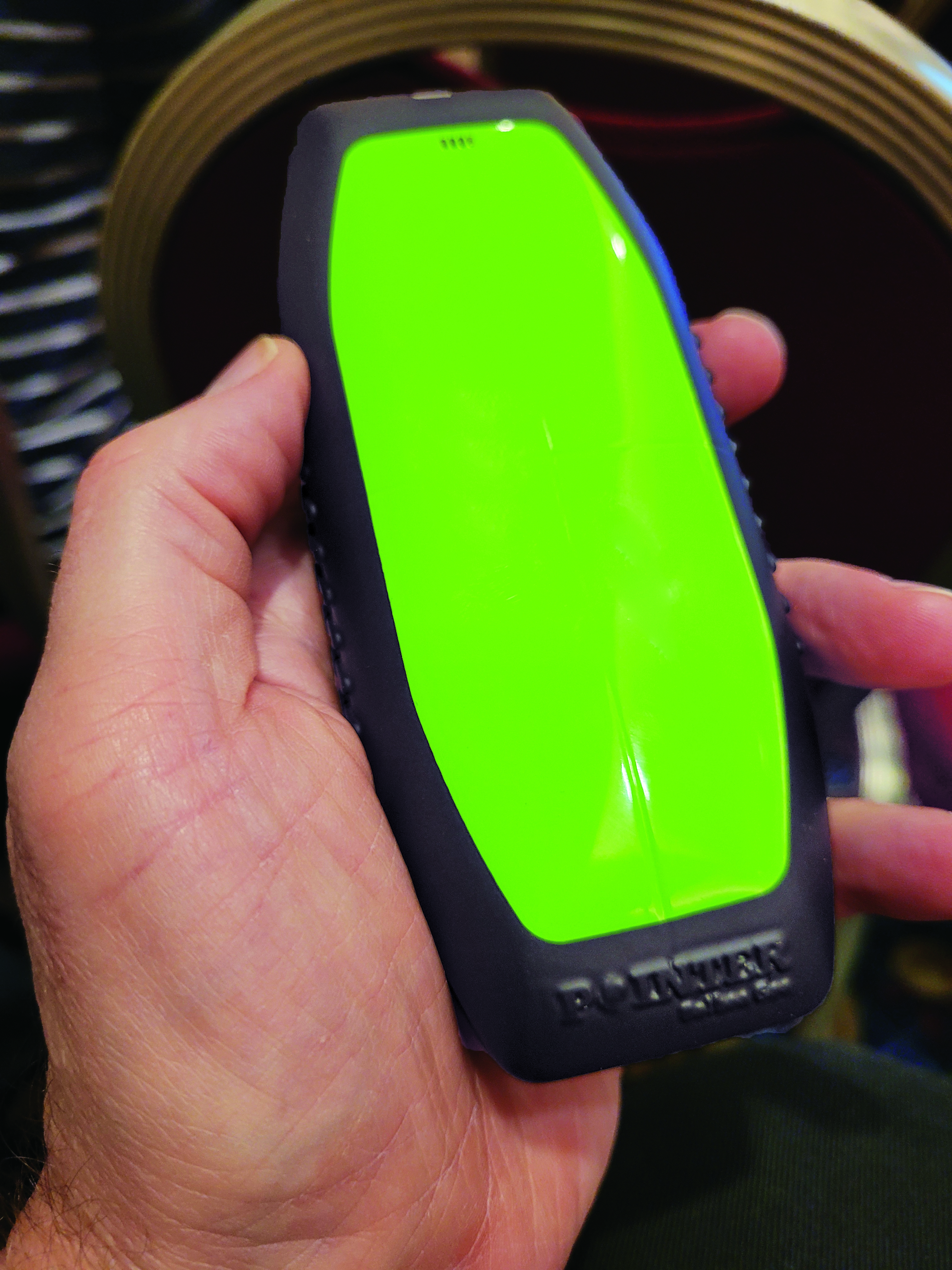
The portable POINTER receivers can be clipped by first responders to their belt, harness, or personal protective equipment, reporting their position in a building, and viewable by an incident commander on a laptop. (Image: Gavin Schrock)
POINTER does not employ radio signals in the fashion of traditional ranging solutions such as GNSS, ultra-wide band (UWB), and various beacon systems for indoor positioning. However, Arumugam said POINTER does generate a radio signal.
“The key difference is that we are detecting the field in a regime where there is no radio propagation mode. Therefore, it is more accurate to refer to this as a quasi-static field, as opposed to a radio propagating wave,” Arumugam said.
Arumugam said Earth’s magnetic field is a good example of this. “It penetrates structures very well, we can measure it 100 kilometers beneath the surface, far above the surface, inside buildings, underwater and so on,” he said. “POINTER uses the kind of the features that you see in Earth’s magnetic field — we are generating quasi-static magnetic fields.
“The term quasi-static highlights the fact that we are trying to keep the physics of the field stationary for all purposes but apply some slow time variation so that it’s really quasi-static to optimize the benefits from both,” Arumugam said. “We get the best of the behaviors of static fields in terms of penetration and non-line-of-sight capability, but also optimize for signal-to-noise by making this a quasi-static signal as opposed to a perfectly static one.”
JPL developed for DHS S&T prototypes that the two organizations tested jointly. Both transmitters and receivers employ an array of three coils, oriented at right angles for x, y and z. The resultant transmitted field carries distinct patterns from these three axes. Distance is detected from field strength, and direction is determined by detecting the pattern of the field relative to the three axes. A key strength of POINTER is that it can achieve ranging and direction from a single base station.
However, Arumugam noted that multiple bases could be beneficial for certain situations.
“The technique as originally developed requires only one transmitter. However, we find that there’s only so much you can get out of a magnetic field, and certain types of structures and materials will perturb that field, causing error.” The second transmitter is not only a backup, but it also helps reduce errors.
POINTER
Geolocation Inc. was spun out from Caltech to license and commercialize POINTER, said Joseph Boystack, executive chairman and co-founder. “We stepped in and executed an exclusive worldwide license for every field of use on this technology in late 2020 from JPL. They had established a proof of concept, and begun testing the technology in the field.”
For the initial commercial version, Balboa Geo made significant improvements over the JPL prototype system. It developed two transmitters that can be deployed on a fixed-mounted basis (buildings, vehicles, ships, etc.) or be portable housed inside a ruggedized, military specification (MIL-STD) case, with a built-in dual antenna GNSS receiver (to position and orient the transmitter).
“If you have an incident involving first responders, military or industrial applications, these remotely configured transmitters can be quickly and easily deployed,” Boystack said. “Also very important, because it only needs to depend on the field generated by the transmitter, we’re not dependent upon other large, fixed infrastructure such as satellites, towers or beacons, and can work in degraded environments where most other position, navigation and timing techniques fail.”
The self-contained receivers are only about the size of a smartphone. The orientation of the receiver is important to determine the “xyz” axis relative to the generated field, thus providing highly accurate three-dimensional position and navigation data. For instance, Balboa Geo’s receiver can be clipped to a first responder’s belt, harness, or personal protective equipment. Similarly, for fixed assets or moving assets such as warehouse systems or robotics, the orientation would be known.
The POINTER system will generate real-time data that can be easily visualized at the job site or event by the incident commander or manager on a laptop or a tablet. The data is interoperable and may be ingested in third-party software applications.
This version meets DHS STS’s original expectations, and subsequent versions will build on it. “S&T relies on experienced emergency response and preparedness professionals to guide our research and development. The First Responder Resource Group is made up of hundreds of state and local volunteers,” Stout said. “We initially looked at tracking firefighters in some of the most common scenarios: two-story house fires.”
While POINTER technology has the potential for much longer ranges and precisions, the current version, Arumugam said, certainly meets the specifications for this initial application. “The current systems can operate up to about 75 meters in range from the transmitter. So, if a transmitter is placed about 10 meters outside the building, say on the fire truck, you can penetrate up to about 65 meters inside the structure. That covers many one, two, maybe three-story structures. Position accuracies can be one meter or less. In principle, you could get to a centimeter, but that’s not required for this technology to be the lifesaver it presently needs to be.”
JPL continues research and development to extend range and increase precision to enable DHS S&T to deploy this technology to ever broader safety-of-life applications where legacy technologies fall short or are completely impractical. Balboa Geo is conducting field and lab tests for many more applications across multiple industries including energy, construction, maritime, mining, the internet of things and more.
Upgraded range of synchronization solutions now includes enhanced PNT resiliency against jamming and spoofing attacks and cyberthreats
ADVA has announced a new software release of its core and edge timing technology, to provide higher levels of positioning, navigation and timing (PNT) security and resilience to synchronization networks. The new release follows the Resilient PNT Conformance Framework issued by the U.S. Department of Homeland Security (DHS).
The upgraded series of PTP grandmaster clock solutions now enables operators to automatically harness public key infrastructure. Along with enhanced certificate management, this delivers more robust security and removes complexity, the company said.
ADVA’s core and mid-sized PTP grandmaster devices now also integrate enhanced aPNT+ technology, providing advanced jamming and spoofing detection as well as mitigation with automatic switchover in the event of cyberattacks.
The software replaces costly hardware devices previously used for PNT protection and achieves enhanced DHS Level 4 Resiliency in PNT self-survivability, the highest in the industry. The new software release also supports 100 Mbit/s over fiber for interconnectivity with optical timing channels from third-party vendors as well as support for PTP profiles for a wide range of industries.
“Today’s timing networks require greater accuracy than ever before. But mission-critical national networks need improved resilience and security as defined by the latest standards. With our trusted PNT assurance solutions, we’re providing the GNSS protection and cybersecurity that today’s operators need to meet current and future challenges,” said Gil Biran, GM of Oscilloquartz, ADVA. “From phase synchronization in critical national infrastructure to traceable timestamping in financial networks, highly precise and protected timing is key to successful operations. This upgrade sets a new standard for secure synchronization and delivers it to more networks than ever before.”
The new 11.1.1 software release features upgrades to ADVA’s comprehensive range of Oscilloquartz edge timing products, the OSA 5412/22 series, as well as its core synchronization devices, the OSA 5430/40 series. The solutions now provide multi-layered security for synchronization infrastructure through improved certification management and PKI.
As part of ADVA’s intelligent and scalable assured PNT platform, the ADVA aPNT+, the solutions also feature innovation for detection of spoofing and jamming as well as countermeasures to prevent service disruption. With PTP capabilities for new verticals, including the PTP broadcast profiles (SMPTE ST-2059-2/AES67), the new release will bring precise, reliable synchronization to many new customers.
The free resources are intended to advance the design of PNT systems and increase resilience of critical infrastructure to PNT disruptions.
The GPS Whitelist Development Guide presents a software assurance approach to addressing potential vulnerabilities and increasing reliability of GPS receivers. The guide addresses data-related requirements in the Resilient PNT Conformance Framework, which provides guidance for defining expected behaviors in resilient PNT equipment.
“We hope this guide and related resources will help industry advance towards a cybersecurity-based approach to PNT resilience,” said S&T Technical Manager Ernest Wong.
Originally released in March 2021 as open source on GitHub, the PNT Integrity Library provides users with a method to verify the integrity of the received GPS data. The update includes:
A compliance check on Interface Control Document (ICD) IS-GPS-200, which is a formal means of establishing, defining and controlling communication between the GPS space and other user systems; and
A Do-It-Yourself (DIY) Toolkit, which describes how a perspective end-user of the PNT Integrity Library can assemble a demonstrational toolkit with commercial-off-the-shelf (COTS) hardware.
“Since GPS signals can be jammed or spoofed, critical infrastructure systems should not be designed with the assumption that GPS data will always be available or will always be accurate,” said S&T Project Manager Brannan Villee. “Application of these tools will provide increased security against GPS disruptions. However, DHS also recommends a holistic defense strategy that considers the integrity of the PNT data from its reception through its use in the supported system.”
Terence James (Terry) McGurn, former GPS World Editorial Advisory Board member and long-time CIA analyst, died on Aug. 28 at the age of 84, according to an obituary in the Fairfax (Virginia) County Times.
After a long career in the CIA and U.S. government, McGurn served as a member of the GPS Independent Assessment Team and its successor, the National Space-Based Position, Navigation and Timing Advisory Board. The board provides independent advice to the National Executive Committee on GPS-related policy, planning, program management, and funding profiles in relation to the current state of national and international satellite navigation services.
McGurn also served as a member of the Independent Review Team sponsored by NASA, which bridged civil and military communities’ GPS issues. He also served on various ad hoc teams that address the criticality of satellite navigation to the nation’s military and civil infrastructure.
He was a member of the GPS World Editorial Advisory Board and was an active member of the Institute of Navigation. He served the CIA and the broader U.S. government until days before he passed away.
McGurn was born in Springfield, Massachusetts on Aug. 24, 1935. He grew up in Jersey City, New Jersey, and he graduated from St. Peter’s Preparatory School in 1953. He moved up his draft and served as a radio operator in the 3rd Armored Cavalry Regiment, and then was discharged as an SP-3 in 1956.
He earned a bachelor’s and masters’ in electrical engineering from the New Jersey Institute of Technology and was Asst. Professor of Physics at NJIT, 1960-69. He earned his doctorate in Electrical Engineering at Stevens Institute of Technology in 1969.
Terry spent his career at Central Intelligence Agency. A senior analyst and leader, he was appointed to the Senior Executive Service (originally Senior Intelligence Service) where he advised generations of policy leaders and operational leaders of the capabilities of the navigation and positioning of the U.S .and of adversaries and other nations.
At the CIA, he developed and implemented methodologies that improved the intelligence community’s ability to assess the performance of foreign weapon systems. He also initiated outreach programs to provide the agency’s unique resources to the departments of Defense, State and Transportation in support of U.S. military, political and economic objectives.
As an expert on the strategic and tactical weapons systems and navigation, guidance and control technologies deployed by potential adversaries, he was able to provide guidance to policy makers regarding the defense of the homeland and of military installations around the world. He briefed at the SECDEF and National Security Council level for decades.
He retired in 2000, the recipient of the CIA Career Intelligence Medal, and numerous Exceptional Accomplishment and Exceptional Performance Awards.
As a consultant, he continued to work with CIA and other agencies in the government, including the DOD, State, the newly established Department of Homeland Security and the Department of Transportation, providing technology and analysis for their diverse missions including security issues related to satellite and terrestrial navigation worldwide.
A long-time resident of Reston, McGurn passed away peacefully at Reston Hospital. He will be laid to rest at Arlington National Cemetery. Reminiscences, condolences and photographs will be posted on this website in the coming months. Memorial donations can be made to the Leukemia and Lymphoma Society or the Animal Welfare League of Arlington.
The U.S. Department of Homeland Security “did exactly what was required by Congress” in issuing its report in June on positioning, navigation and timing (PNT), according to a letter sent by numerous PNT companies to the DHS.
The July 17 letter to Chad F. Wolf, acting secretary of Homeland Security, refutes a previous letter from Congressional representatives that the report contained numerous errors and failed to address many of the things Congress had required.
“We believe that some key claims made in the members’ letter of June 9 are either exaggerated, irrelevant to the report’s Congressional tasking, or simply wrong,” states the July 17 letter, which is signed by senior executives of Satelles, Orolia, Iridium, Navsys, Jackson Labs, Seven Solutions and Qulsar.
The group takes on the claims of the representatives point by point, finding them exaggerated, irrelevant or incorrect.
For instance, the letter critical of the DHS report states:
“The report focuses on the needs of ‘industry’ largely ignoring the needs and impacts on public services (including first responders), government operations, and individual citizens.”
In response, the industry representatives state:
“The focus of the report, as directed by the NDAA, is on the requirements of the owners and operators of national critical infrastructure. This includes “public services, government operations,” and its beneficiaries, “individual citizens.” To the extent that the report focuses on incentivizing the industry, it is in order for it to be able to meet these requirements.
“While the report only highlights PNT use cases from a subset of the 16 critical infrastructure sectors, their pragmatic recommendations address a range of requirements across all sectors. With respect to PNT needs for backing up GPS, DHS acknowledges the differences between and commonalities among the sectors and offers exceptional guidance for leveraging the capabilities of diverse forms of commercially available alternative PNT rather than endorsing a single, anti-competitive, government-imposed solution.”
The U.S. Department of Homeland Security (DHS) Science and Technology Directorate (S&T) is hosting the 2020 GPS Equipment Testing for Critical Infrastructure (GET-CI) event. This event will take place during the summer of 2020.
The revised the due date for responses is May 8, 2020. Visit this site for more information.
S&T’s GET-CI events are a series of annual evaluation events intended for manufacturers of commercial GPS equipment used in critical infrastructure as well as critical infrastructure owners and operators.
DHS S&T recognizes the importance of accurate and precise position, navigation and timing (PNT) information to critical infrastructure and has a dedicated multi-year program to address GPS vulnerabilities in critical infrastructure, with a multi-pronged approach of conducting vulnerability and impact assessments, developing mitigations, exploring complementary timing technologies, and engaging with industry through outreach events and meetings.
Through these sustained efforts, the goal of the program is to increase the resiliency of critical infrastructure to GPS vulnerabilities in the near-term future.
Examples of measures that can be taken to enhance resiliency can be found in a DHS issued set of best practices released via ICS-CERT, titled “Improving the Operation and Development of Global Positioning System (GPS) Equipment Used by Critical Infrastructure.”
The U.S. Department of Homeland Security (DHS) has released a memorandum about a GPS rollover event coming in April 2019.
The memorandum, U.S. Owners and Operators Using GPS to Obtain Time, is intended to provide an understanding of the possible effects of the April 6, 2019, GPS Week Number Rollover on Coordinated Universal Time (UTC) derived from GPS devices.
DHS recommends that critical infrastructure and other owners and operators prepare for the rollover. They should:
investigate and understand their possible dependencies on GPS for obtaining UTC;
contact the GPS manufacturers of devices they use to obtain UTC;
understand the manufacturers’ preparedness for the ollover;
understand actions required by CI and other owners and operators to ensure proper operation through the ollover, and
ensure that the firmware of such devices is up to date.
The memorandum is sponsored by the Department of Homeland Security’s National Cybersecurity and Communications Integration Center in coordination with the Department of Homeland Security’s Science and Technology Directorate, the Department of Homeland Security’s National Protection and Programs Directorate Office of Infrastructure Protection and the National Coordination Office for Space-Based Positioning, Navigation and Timing.
GPS World discussed in-depth the previous rollover event in an Innovation column.
Two documents of interest and importance to GNSS designers and manufacturers have been published, one from the Radio Technical Commission for Maritime Services (RTCM) and one from the U.S. Department of Homeland Security (DHS).
The latter document is the subject of a news story concerning receivers used in critical infrastructure, with an emphasis on timing receivers. It provides owners, operators, researchers, designers and manufacturers with information to improve the security and resilience of PNT equipment across the spectrum of equipment development, deployment and use. It makes specific recommendations.
The first-mentioned document is a white paper issued by the RTCM. It follows here, largely verbatim. It is titled “GNSS Community Benefit from Strong International Coordination and Cooperation,” and it addresses an important issue for GNSS receiver manufacturers and others concerning use of BeiDou signals. The authors believe that early publication and dissemination of the recommendation is needed to prevent possible confusion down the line.
GNSS Community Benefit from Strong International Coordination and Cooperation
Introduction
The ephemeris broadcast by China’s BeiDou Navigation Satellites do not directly provide unique identifiers that are similar to the GPS’s “Issue of Data, Ephemeris” (IODE) and “Issue of Data, Clock” (IODC) values. Special Committee #104 (SC-104) of the Radio Technical Commission for Maritime Services (RTCM) has been working with the China Satellite Navigation Office (CSNO) to ensure that equivalent BeiDou IODE and IODC values can be generated.
This paper presents the BeiDou IODE and IODC calculation algorithms that were developed by RTCM’s SC-104 and are being shared with the GNSS community in an effort to promote consistent BeiDou IODE and IODC computational approaches within the community.
Background
Most GNSS position and timing related algorithms need to know exactly where the satellite was at the moment the signal component of interest was transmitted. The signal sent from these satellites also contain messages, which contain parameters used to calculate the position and clock errors of that satellite for a moment of interest within the validity period of those orbital parameters. Because this validity period is relatively short (e.g., +/-4 hours of the current time), the satellites are periodically broadcasting new orbital parameters. These orbital parameters are often referred to as the satellite broadcast ephemeris. Plots from the different broadcast ephemeris for the same satellite do not directly overlay each other because there are forces acting on those satellites (such as solar wind, ionospheric drag, and gravitational anomalies) that do not permit long term exact prediction of orbits and clocks.
Many differential correction services require both the correction generator system (e.g., reference station and reference networks) and the correction consumer (e.g., GNSS rover receivers) know and use the exact same orbital parameters. That is, the consumer of the corrections needs to apply those corrections using the exact same orbital parameters as those used to create the corrections. Failure to do so results in errors and biases for reasons earlier described. In such correction services, the correction message contains information enabling the consumer to uniquely identify the orbital parameters used by the generator.
Correction services need a mechanism to uniquely identify the orbit parameters used by the correction generator system. The GPS Broadcast ephemeris messages are uniquely identified for a certain period of time by what are known as the “Issue Of Data, Ephemeris” (IODE) and the “Issue of Data, Clock” (IODC). Other GNSS constellations have similar concepts, or at least other parameters that can be used for similar purposes. Unfortunately, the 2011, 2012 and 2013 BeiDou Signal-In-Space Interface Control Documents (BDS-SIS-ICD) have offered no information enabling one to develop some mechanism for such a unique identification.
In 2013 RTCM SC-104 created the BeiDou Working Group (BDS WG). Since then, the BDS WG has worked closely with the China Satellite Navigation Office (CSNO) to ensure proper inclusion of BeiDou in RTCM standards and recommendations. As part of this effort, RTCM SC-104 and the CSNO explored several avenues concerning equivalent BeiDou values of IODE and IODC. Ultimately an approach was selected by the CSNO. The selected approach stems from a ground-segment based approach which does not require a change to the BeiDou broadcast message format. However, it does then require that the users of BeiDou needing IODE and/or IODC values ensure that they employ the exact same algorithm to compute those values from the data available in the broadcast ephemeris.
In May 2016, Kendall Ferguson (RTCM SC-104 Chair), Shaowei Han (Wuhan Navigation and LBS, Ltd. and Chair of the RTCM SC-104 BDS WG), and Dr. Hui Liu (Wuhan University /Wuhan Navigation and LBS, Ltd. and co-Chair of the RTCM SC-104 BDS WG) met with the Deputy Director of the CSNO. In that meeting, the CSNO Deputy Director indicated that a soon to be release BDS-SIS-ICD would provide information that would enable calculation of equivalent BeiDou IODE and IODC values. In November 2016, the CSNO released the BDS-SIS-ICD, Version 2.1, and that ICD contains the needed information.
The language in the new BDS-SIS-ICD indicates that the normal ephemeris update (i.e., with new ephemeris parameters) will occur every hour on the hour when everything is normal. If new parameters are needed for whatever reason, they will occur on 12 minute slots within the hour. Any parameter that is changed in a broadcast ephemeris that is related to toc will result in a new toc (coincident with the 12-minute slot of the hour). Likewise, any parameter that is changed in a broadcast ephemeris that is related to toe will result in a new toe (coincident with the 12-minute slot of the hour). Whenever toc changes so will toe. There will be no repeated toc or toe values within a week.
On February 3, 2017, RTCM SC-104 formally approved algorithms for BeiDou ephemeris unique identifiers that can be computed by both message generators and message consumers. The reason for announcing this approval is to proactively prevent a wide variety of BeiDou IODE/IODC algorithms from emerging throughout the GNSS community.
These RTCM BeiDou IODE and IODC algorithms are:
BDS IODC=mod (toc / 720, 240)
BDS IODE=mod (toe / 720, 240)
The modulo 240 gives an 8-bit IODE (and an 8-bit IODC) that provides 2 days of uniqueness and which offers the smaller bit size needed for correction messages. The values from 240 to 255 thus offer some future expansion should additional cases be needed.
Unlike the relationship between the GPS IODE and GPS IODC, the BDS IODC may not be equal to the BDS IODE. The BDS IODC may be updated much more often than BDS IODE. However, whenever the BDS IODE is changed, the BDS IODC is also changed at the same time. Thus, RTCM will be using the BDS IODC as the unique ephemeris identifier in its messages.
Conclusions
Special Committee #104 (SC-104) of the Radio Technical Commission for Maritime Services (RTCM) has been working with the China Satellite Navigation Office (CSNO) seeking methods where by BeiDou equivalents of the GPS IODE and IODC might become available. The BDS-SIS-ICD, Version 2.1, released November 2016, provides information about the constellation allowing computation of IODE and IODC values from its broadcast ephemeris. In February 2017, RTCM SC-104 approved the algorithms it will use to compute unique ephemeris identifiers that will be contained in its messages, thus allowing the recipients of RTCM BeiDou related messages to identify the ephemeris used by the sender of such messages. RTCM is announcing these algorithms in an effort to prevent a variety of such algorithms from emerging and thus causing community confusion.
In early January, a new U.S. Department of Homeland Security (DHS) document appeared: “Improving the Operation and Development of Global Positioning System (GPS) Equipment Used by Critical Infrastructure.”
The document focuses on receivers used in critical infrastructure, with an emphasis on timing receivers. It provides owners, operators, researchers, designers and manufacturers with information to improve the security and resilience of PNT equipment across the spectrum of equipment development, deployment and use.
Specifically, its recommendations address:
installation and operation strategies that can be implemented for current equipment,
strategies that can result in more robust and resilient new and/or improved products based on existing technology and knowledge,
research and development that can lead to improved future capabilities.
It introduces clear definitions of different categories of threats and hazards, including the new term “data spoofing.” It recommends some creative ways to install receive antennas, such as using decoy antennas and obscuring the location of the actual antennas being used, presumably to foil some spoofing attacks. It also points out that modern GNSS receivers are computers, and need to be operated and maintained with good cyber hygiene, just like other computers.
The extensive list of recommended development strategies will challenge manufacturers while informing purchasers about the features they can seek in new equipment.
Implementing these recommendations will lead to increased competence — that is, equipment that is better able to accommodate imperfect or faulty inputs, intentional or not.
The document reflects the recognition that many reported problems or difficulties with GPS could be prevented or mitigated by improvements in GPS user equipment and how it is installed and operated. It is encouraging to see DHS taking steps to remedy this situation, and important that manufacturers of timing receivers, as well as critical infrastructure owners and operators that use timing receivers, follow through on these recommendations.
The document is posted on the website for DHS’ National Cybersecurity & Communications Integration Center, National Coordinating Center for Communications-Computer Emergency Readiness Team.


 The document focuses on receivers used in critical infrastructure, with an emphasis on timing receivers. It provides owners, operators, researchers, designers and manufacturers with information to improve the security and resilience of PNT equipment across the spectrum of equipment development, deployment and use.