Tag: direct georeferencing

  • Applanix: NOAA’s eye for hurricanes

    Applanix: NOAA’s eye for hurricanes

    Photo: NOAA
    High-resolution imagery geolocated by the sixth-generation Digital Sensor System (DSS) after Hurricane Ida. (Photo: NOAA)

    Applanix, a division of Trimble, has been working with the National Oceanographic and Atmospheric Administration (NOAA) since the early 2000s to develop their response for emergency and coastal mapping activities. We discussed this collaboration with Joe Hutton, the company’s director of inertial technology, land and airborne products.


    How has Applanix collaborated with NOAA regarding emergency response and coastal mapping?

    Early on, we worked with them to develop a solution that allowed them to get out in the field and produce high accuracy map products with minimal touching of the data. In mid-2021, we delivered the next generation of this solution, or the DSS version six, which represents the culmination of everything learned over the years about how to produce imagery for emergency response, in terms of the types of collection, the types of imagery, and how to get it into first responders’ hands as quickly as possible.

    At the heart of the system is our direct georeferencing technology. It’s a solution that allows us to assign the geographic location of every pixel of the digital imagery collected in the air. As soon as you land, you have the coordinates of every pixel, which means that you have a map that NOAA then pushes to the cloud for first responders to use in their emergency response efforts.

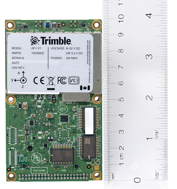
    The collaboration consisted of Applanix working with Lead’Air to manufacture the next generation system that meets NOAA’s latest requirements. That’s what we delivered in 2021. Weeks after delivery, NOAA was called to respond to the hurricanes. They flew the new system with great success and were able to use it for their response.

    What is your perspective on ground control points (GCPs) vs. direct georeferencing?

    It is impossible to place GCPs in an emergency response when you cannot get on the ground. People who say they need GCPs do not really understand direct georeferencing. We’re having this debate even after 20 years of proving this technology. The NOAA system does not use GCPs and the map products are at centimeter level accuracy.

    We use Trimble’s RTX technology, which enables centimeter-level GNSS positioning without base stations, which is important when the CORS or local RTN is unreliable due to a disaster. We have high accuracy inertial systems that get us the high accuracy orientation, so that we can go directly to ortho photos and ortho mosaics without running any triangulation or using GCPs in that process. That is a standard process these days. GCPs are only there for quality control if you want to deliver a final map product.

    Did NOAA fly the mission with its own aircraft?

    Yes, these are NOAA’s King Air or Twin Otter aircraft. The King Air aircraft is specifically outfitted for these types of emergency response and coastal mapping activities. The DSS system gets installed into the airplane and gets calibrated in terms of checking the system out for accuracy. Then it’s ready to fly the response. In the air, they collect the imagery over a flight path of interest to them. Then, it’s developed from raw imagery into JPEGs in the aircraft, and all the georeferencing data is logged with that imagery so that as soon as they land they can push a button and start to reference the JPEG imagery and push it to the cloud.

    What are the components of your system?

    What makes this system so unique is that it encompasses all the lessons learned over the years in terms of what NOAA needs to optimize for both their coastal mapping and their emergency response. It incorporates two pairs of color and near-infrared Phase One cameras that are configured in an oblique format with some overlap, forming a bowtie footprint on the ground.

    You have 100% overlap of the color with the near-infrared and it’s on a high-performance stabilized mount that keeps everything perfectly level. The mount also has a special feature that enables the operators to rotate the cameras to go into nadir mode, mostly for traditional coastal mapping that requires stereo imagery. We were able to incorporate into a single system the requirements for both emergency response—where you want large coverage and obliqueness to look for damage—and nadir for coastal mapping.

    Lead’Air built the sensor for you, on your specs, correct?

    Yes, that’s correct. We’ve worked with Lead’Air for probably 20 years on flight management system (FMS) technology. They also have an amazing capability to build stabilized mounts and hardware systems. So, we decided to work together. We contracted them to implement some of their innovative hardware in this new design for us to deliver to NOAA. We contracted them to do all the manufacturing of the design and delivery to NOAA.

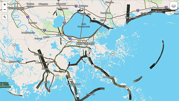
    One of the quite innovative things that they did was to develop a new flight management capability that allows NOAA to fly ad hoc along highways or rivers, looking for damage. Traditionally, for aerial imagery you have to pre-flight plan trajectories. They designed an FMS that enables a pilot to fly a road or a river looking for damage without worrying about traditional block collections as with a more traditional FMS. So that feature further increases productivity. If you look at the most recent imagery at www.storms.ngs.noaa.gov you will see that it looks like spaghetti, not like blocks. That’s because they are following the roads and the rivers looking for specific damage.

    Does the post-processing use your software?

    Yes, it uses the POSPac MMS post processing software with POSPac Trimble Post-processed CenterPoint RTX correction service, allowing us to get that centimeter-level position accuracy, anywhere in the world with just an internet connection. You don’t have to worry about having a local base station—which, of course, if you’re in an emergency response situation, might not be there anyway. So, this is a very powerful way of getting global centimeter-level accuracy in real time, without having to worry about the ground-based GNSS infrastructure, that is, the local real-time network, that’s on the ground.

    If you don’t have internet access, you can ship that data to the nearest place that does, right?

    You could, however NOAA simply flies to wherever there is access. What takes the longest is to develop the imagery from the raw format to the JPEG format, because these are such large images. Doing that in the air saves an enormous amount of time. You have these JPEG-ready images that are compressed and can go right into the georeferencing process and make it really, really fast.

    That’s a matter of computing power and smart software. What else did Lead’Air contribute?

    This very efficient, fast image development process in the aircraft.

    It sounds like it was a very integrated process between Applanix and Lead’Air. So, NOAA had the instrument mounted on their aircraft, their pilots did the flying, and then you processed the data?

    No, NOAA’s team processes all the data. We just deliver the hardware and the software. They created the workflow software to push the data to their cloud environment.

    NOAA uses this data to produce maps of the damage and highlight different situations and hazards?

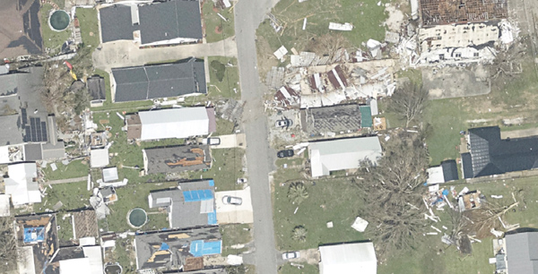
    Yeah. When these hurricanes go through, the first questions people have are “Where’s the damage? Are these roads passable? Did my house survive?” If you are doing response, you need to get teams in there. First, however, you need to know whether the roads are passable, so that you will not waste time going down a road that is not. So, the first thing they do is go up in the air and survey the main roads to push the imagery back, so that people can assess whether the roads are passable. Then they start to look for specific areas of damaged infrastructure, to triage where to put their resources. Then they ask “How do we manage disaster recovery?”

    What lessons did you learn?

    We are still learning about the power of the system, because these are Phase One 150 megapixel color cameras. It is such a powerful combination of sensors that they’re starting to look at different information they can get out of these things. They’re still learning new lessons in terms of what information can be useful for both the emergency response and the coastal mapping.

    Ultimately, we’ll go to full ortho maps in the aircraft. That’s just going to be a matter of computational power. The holy grail would be to produce an orthophoto in the aircraft and radio it down to the ground in real time. Nothing prevents you from doing that now other than computational power and bandwidth. It’s not practical yet, but it will probably get there.

    Do you have collaborations like the one with NOAA with any other major U.S. agencies?

    We’ve worked extensively with NASA over the years. For example, we have worked with them on the ice bridge project. That is where they survey ice at both poles to measure its thickness and how global warming is affecting it. They use our system on that to do the georeferencing. We also work extensively with other branches of NOAA for their shoreline mapping from their ships. We have worked with them over the years to provide the georeferencing solution for the multibeam echo sounders to produce their nautical charts.

  • Applanix joins with NOAA on hurricane assessment imagery

    Applanix joins with NOAA on hurricane assessment imagery

    Hurricane Ida assessment imagery and data are now available. Ida was a Category 4 Atlantic hurricane from Aug. 26 to Sep. 4. (Screenshot: NOAA)
    Hurricane Ida assessment imagery and data are now available. Ida was a Category 4 Atlantic hurricane from Aug. 26 to Sep. 4. (Screenshot: NOAA)

    Applanix, a Trimble Company, and the National Oceanic and Atmospheric Administration (NOAA) have collaborated to provide critical information to first responders in the wake of Hurricanes Henri and Ida.

    Applanix’s high-accuracy direct georeferencing (DG) technology enabled NOAA to quickly collect aerial mapping imagery to

    1. provide valuable disaster remediation information to first responders
    2. demonstrate the value of mapping technology in preparing for and responding to emergency situations such as hurricanes, tornadoes and other disasters.

    Within hours of Hurricanes Henri and Ida making landfall, NOAA’s National Geodetic Survey collected post-storm imagery using the latest generation Digital Sensor System (DSS). The sixth-generation DSS, designed and manufactured for Applanix by Lead’Air, is the most powerful to date, thanks to several new features introduced within the solution:

    • simultaneous full color and near-infrared image capture using high-performance Phase One iXM 100 MP NIR and 150 MP RGB cameras
    • option to fly the cameras in wide coverage oblique or traditional overhead (straight line down) mode for mapping with uninterrupted measurement
    • embedded Trimble AP60 GNSS + inertial OEM DG solution for mapping without the need for ground control or aerial triangulation
    • Applanix POSPac post-processing software featuring the Trimble post-processed CenterPoint RTX correction service (PP-RTX) for centimeter-level mapping without GNSS reference stations
    • in-air development of raw imagery to JPEG-ready files for creating map products immediately upon landing
    • Lead’Air’s X-Track flight management, which enables the system to be flown outside of planned flight lines to follow roads, rivers and coastlines.

    Applanix’s DG technology suite provides direct GNSS inertial georeferencing, meaning that all pixels in the aerial images taken by NOAA are mapped at their exact location on the ground.

    “We have worked with Applanix for nearly 20 years,” said Michael L. Aslaksen Jr., chief of the remote-sensing division, NOAA’s National Geodetic Survey. “The level of sophistication they bring to aerial imagery and mapping keeps our team at the forefront of the industry. Their customer support team is always open to new ideas, new innovations and doing whatever it takes to get the job done.”

    First responders have access to this imagery and mapping within 24 hours via the cloud (as does anyone at storms.ngs.noaa.gov) and can map detailed response plans based on highly accurate data highlighting where the greatest need lies.

    Access to this turnkey emergency response imagery is available to any federal agency, municipality, insurance company or other entity that depends on highly accurate information to plan for and recover from disasters.

  • Applanix introduces OEM solution for direct georeferencing of airborne sensor data

    Applanix introduces OEM solution for direct georeferencing of airborne sensor data

    Photo: Applanix
    Photo: Applanix

    Applanix, a Trimble company, has introduced the Trimble AP+ Air OEM solution for direct georeferencing of airborne sensor data.

    The solution enables users to accurately and efficiently produce maps and 3D models without the use of ground control points.

    The Trimble AP+ Air is a powerful solution for manned platforms, yet small enough for use on unmanned aerial vehicles (UAVs). It is also compatible with virtually any type of airborne remote sensor, including photogrammetric cameras, lidar, hyper and multispectral cameras, and synthetic aperture radar.

    Comprised of next-generation compact, low-power hardware, the Trimble AP+ Air features dual embedded survey-grade GNSS chipsets, an onboard inertial measurement unit (IMU), an external IMU, and the all-new Applanix IN-Fusion+ GNSS-aided inertial firmware. It is configurable to support the direct georeferencing accuracy demands of low-flying UAVs to high-altitude manned platforms.

    “We have taken the most advanced features of Applanix direct georeferencing and Trimble GNSS technology and packaged them into a powerful new, compact and versatile solution,” said Joe Hutton, Applanix’ director of inertial technology and airborne products. “It provides the flexibility required by systems integrators to embed a single hardware solution that can then be configured to meet the different direct georeferencing needs of a specific sensor type, whether flown on a UAV or manned aircraft. It truly is an ‘integrate once, use many times’ solution.”

    The Trimble AP+ Air is fully supported by the Applanix POSPac MMS post-processing software, which features CenterPoint RTX post-processing for centimeter-level positioning anywhere in the world without the need for base stations. These capabilities make the solution ideal for integrators to produce a highly efficient airborne mapping system.

    For lidar integrators, the Trimble AP+ Air is compatible with the POSPac MMS LiDAR QC Tools for computing boresight as well as adjusting the relative accuracy of the POSPac trajectory being used to generate the point cloud. For integration with cameras, the solution is supported by the POSPac MMS Photogrammetry Tools for computing boresight and performing camera IO quality control.

    The Trimble AP+ Air OEM solution and POSPac MMS are available through Applanix sales channels.

  • Trimble offers direct georeferencing GNSS/inertial for UAVs

    Trimble offers direct georeferencing GNSS/inertial for UAVs

    Trimble is offering three new GNSS-inertial systems for direct georeferencing on unmanned aerial vehicles (UAVs): the Trimble APX-15-EI UAV, Trimble APX-18 UAV and Trimble APX-20 UAV.

    Direct georeferencing with the systems allows the location of image elements collected by lidar and hyperspectral sensors to be accurately computed without extensive networks of ground control points, reducing costs while maintaining accuracy to produce maps.

    The APX products use state-of-the-art low noise, multi-frequency Trimble Maxwell GNSS technology, and track all current satellite signals including GPS L1/L2/L2C/L5 and GLONASS L1/L2, QZSS, BeiDou, IRNSS and Galileo, supporting SBAS, RTK and Trimble CenterPoint RTX positioning modes.

    The APX-15-EI UAV features dual inertial measurement units (IMU); one embedded onto the GNSS-inertial board that is mounted on the UAV airframe with the GNSS antenna, and one that is mounted on an external sensor contained in a gimballed mount.

    With this feature, the APX-15-EI UAV can compute two sets of orientations — the UAV airframe and the gimballed mount —  enabling automatic, precise positioning of the sensor without requiring an external interface to the gimballed mount or autopilot.

    The APX-20 GNSS-inertial board by Applanix.

    The APX-18 UAV is a single-board GNSS-inertial solution that supports two-antenna heading for the highest accuracy in low-speed multi-rotor survey applications such as building facade scanning. Measuring  10 x 6 centimeters and weighing 62 grams, the APX-18 UAV uses on-board inertial sensors calibrated with the Applanix SmartCal software compensation technology for superior performance in a small, compact form for UAVs.

    To meet the higher accuracy demands driven by the allowance of higher altitude, beyond visual line of sight (BVLOS) UAV flights and the introduction of higher resolution, larger format imaging sensors, Trimble has developed the APX-20 UAV.

    Also featuring dual IMUs for automatic gimballed mount support, the APX-20 UAV uses a new, MEMS-based lightweight external IMU with unparalleled performance. With a total weight of less than 425 grams, the APX-20 UAV provides high performance without sacrificing flight time.

    “We are very pleased to announce these new additions to our portfolio of products for Direct Georeferencing on UAVs,” said Joe Hutton, director of inertial technology and airborne products at Applanix, a Trimble Company. “We have listened to our customers and worked very hard to come up with solutions that meet their needs, both from a technical and cost perspective.”

    All APX products include the Applanix POSPac UAV post-processing software for generation of high-accuracy carrier-phase differential GNSS-inertial position and orientation for highest accuracy map products.

    POSPac UAV supports single GNSS base-station processing with automatic coordinate survey using Trimble CenterPoint RTX, multi-single base station processing, and Applanix SmartBase Virtual Reference Station processing (optional), as well as the Trimble CenterPoint RTX post-processing trajectory generation available as a subscription.