By Yury Urlichich, first deputy director general of Roscosmos State Space Corporation Sergey Karutin, designer general of GLONASS Nikolay Testoedov, director general, Information Satellite Systems JSC
Sergey Koblov, director general, Central Research Institute of Machine Building JSC
The year 2020 heralds the end of another 10-year stage of development of the Russian GLObal NAvigation Satellite System (GLONASS). Reconstruction of our orbital constellation, started in 2006, is bearing its fruit. Today, it is hard to imagine one’s daily life without the continuous artificial radio-navigation field provided to users globally by the GLONASS orbital constellation since 2011.
GLONASS signals are employed to perform a wide range of tasks, such as
Saving lives in road accidents
Air, ground and naval traffic monitoring and control
Network synchronization of mobile cellular communications
Monitoring and enabling the energy grid, road travel, agricultural equipment operation, and more.
Our orbital constellation is built upon a base of second-generation spacecraft (SC) — Glonass-M SC — that was developed in 2003 and has demonstrated outstanding operational capacity: 14 SC are already operating well beyond their expected lifetimes, and four SC celebrate their 13th birthday in orbit this year. Activities focused on improving GLONASS accuracy have not stopped for a single day.
If we go back to 2014, the SC-based ranging offset (which specialists refer as equivalent ranging deviation) was 1.4 m. We managed to achieve 0.9 m offset on Jan. 30, 2020, and during the same week the offset did not exceed 1.15 m. Furthermore, the penultimate series-produced Glonass-M SC (Cosmos-2545), which was launched on March 30, demonstrated basic service ranging accuracy of 0.38 m on a daily interval and 0.63 m accuracy on the “best week” interval.
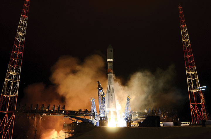
Glonass-K No. 15 was launched into orbit on Oct. 25. (Photo: Roscosmos)
It was Glonass-M SC development that enabled users around the world to gain access to the first dual-frequency navigation service, which is necessary for decreasing the effects of the ionosphere on navigation accuracy.
The third generation of GLONASS SC — Glonass-K — was successfully launched from the Plesetsk launch site on Oct. 25. This SC will provide users with a broader range of capabilities — and a more accurate and informative signal in the L3 frequency band. Further gradual rejuvenation of the GLONASS constellation will ensure the ever-improving quality of our navigation services.
Two Glonass-K2 SC are planned for the launch campaign in 2021, and all the experience accumulated during the development of third-generation GLONASS SC (Glonass-K) will be implemented in the fourth-generation SС. Glonass -K2 is a unique SC: It will provide users with five navigation signals, its accuracy will be within 0.3–0.5 m, and its assured expected lifetime will be at least 10 years.
High-Orbit Space Complex
GLONASS developers remain focused on user requirements. Recent surveys show a growing demand for high-quality navigation services in difficult conditions where the SC is visible at more than 25° above the horizon. To satisfy these needs with the implementation of new CDMA signals, development of the GLONASS High-Orbit Space Complex (HOSC) will begin in 2021. Its first SC will be launched in 2025, and complete deployment of the constellation including six SC in three or six planes will be finished by the end of 2027.
As a result, the accuracy and availability of navigation in difficult conditions will improve in the Eastern Hemisphere. But the major anticipated outcome of the HOSC implementation is assured two-fold coverage of the Northeastern segment of the globe with high-accuracy differential navigation data by GLONASS and other GNSS.
HOSC implementation will ensure 25% navigation accuracy improvement over the Eastern hemisphere. Glonass-K SC will be used as a base platform for HASC deployment due to its excellent record.
Ground Control at the Titov Main Test Space Center established a stable telemetry connection with the new satellite shortly after launch. (Photo: Roscosmos)
User Interface Harmony
One of the most important tasks for the year 2020 is harmonization of the GLONASS user interface. As we already mentioned, the signal propagation environment has a strong effect on navigation accuracy; therefore, new issues of GLONASS Interface Control Documents (ICD) are being prepared for publication.
We anticipate that GLONASS end-user accuracy improvement will be achieved through introducing additional information into reserve bits of navigation frames, including relevant parameters of an ionospheric model.
The ICD will contain operating methods with parameters of the ionospheric model and definite recommendations designed for compensation of ionospheric delays by both single-frequency and dual-frequency receivers, as well as generalized methods for compensating for tropospheric delays.
Changes in the ICD concerning FDMA and CDMA signals will ensure backward compatibility and uninterrupted operation for the existing range of user navigation equipment.
Yang Changfeng, chief architect, BeiDou Navigation Satellite System, speaks at an international event. (Photo: BDS)
On July 31, 2020, BDS-3, the global version of the BeiDou Navigation Satellite System (BDS), was formally commissioned, marking the completion of its three-step development process. BDS enters a new era of global services. With the principle of “serving the world and benefiting mankind,” BDS provides seven types of services to users worldwide, including positioning, navigation and timing (PNT) services, a global short-message communication (GSMC) service, a regional short-message communication (RSMC) service, an international search-and-rescue (SAR) service, the BeiDou satellite-based augmentation system (BDSBAS), the BDS/GNSS ground-based augmentation system (BDGAS), and the precise point positioning (PPP) service. BDS has been continuously making contributions to improving GNSS capabilities and promoting the development of GNSS applications and technologies.
In 2020, as BDS construction was successfully completed, BDS has made fruitful achievements in application development and internationalization.
System Construction
Space Constellation Deployment. From March to June 2020, two BDS-3 GEO satellites were launched, while the in-orbit tests of two IGSO satellites, two GEO satellites, and two MEO satellites were completed. As the result, the global system constellation was successfully deployed.
By the end of October 2020, 45 in-orbit operational BDS satellites provide services to global users, including 15 BDS-2 satellites and 30 BDS-3 satellites.
Ground System Development. More than 40 new ground stations have been built, tested and commissioned. The BDS ground system is operating stably, supporting daily BDS operations.
Basic Service Enhancement
Generally speaking, the accuracy of the BDS signal-in-space is better than 0.5 m, BDS global positioning accuracy is better than 10 m, BDS velocity measurement accuracy is better than 0.2 m/s, and BDS timing accuracy is better than 20 ns. In the Asia-Pacific region, BDS positioning accuracy is better than 5 m, the velocity measurement accuracy is better than 0.1m/s, and timing accuracy is better than 10 ns.
In the key service area, there are 30 BDS-3 satellites and 15 BDS-2 satellites that jointly provide the services using B1I and B3I signals. The actual average measured positioning accuracies are about 1.48 m horizontally and 2.99 m vertically (95% confidence), which are improvements of about 30% and 5% respectively as opposed to solely relying on the BDS-2 system.
Globally, with the B1I, B3I, B1C and B2a signals, BDS-3 offers service availability of 100% (PDOP ≤6,). The actual measured positioning accuracies are about 1.54 m horizontally and 2.65 m vertically (95% confidence).
Featured Services Benefit Users
Presently, the BDS PPP service covers China and its surrounding areas. By broadcasting the high-precision orbit and satellite clock error corrections through the B2b signal, the high-precision positioning service is provided, while initial testing measurements show that the positioning accuracies are about 0.18 m horizontally and 0.26 m vertically (95% confidence).
BDSBAS was developed in accordance with International Civil Aviation Organization (ICAO) standards to provide SBAS services with superior accuracy and integrity, enabling aircraft approach with vertical guidance of class I (APV-I). The BDSBAS services cover China and its surrounding areas, and the SBAS data, following ICAO standards are broadcast by the three BDS GEO satellites. In particular, the single frequency SBAS service is being provided through the BDSBAS-B1C signal. At the moment, the civil aviation certification process of the BDSBAS SF service is being prepared. The BDSBAS-B2a signal will provide the Dual Frequency Multiple Constellation (DFMC) SBAS service. BDS has been actively participating in the development process of the DFMC standards and carrying out the verification of the draft DFMC SBAS Standard and Recommended Practices.
BDGAS consists of 155 framework reference stations and nearly 2,200 regional stations in China. The system carries out high-precision applications in many fields, such as surveying and mapping, land resources, earthquake monitoring, transportation and meteorology. Its basic services include real-time positioning at the meter, decimeter and centimeter levels, as well as precise post-processing positioning at the millimeter level.
Being developed in accordance with Cospas-Sarsat standards, the BDS MEO-SAR service provides the detection probability of the international search-and-rescue service of better than 99%, with the characteristic return link capability. In July, a joint test was carried out using the BDS MEO-SAR satellites with the Cospas-Sarsat ground station in Maryland, U.S., and the relevant technical documents and the equipment admittance testing reports were formally submitted to Cospas-Sarsat, which provides Chinese contributions to the international MEO-SAR family.
RSMC provides service to China and its surrounding areas through three GEO satellites. Its communication capability is greatly improved compared to BDS-2. With service capacity of 12 million times per hour, the transmitting power of user terminals is reduced to 1-3 W and the single message capacity reaches 1,000 Chinese characters. The construction of the RSMC service platform has been completed to promote the organic integration of short message and mobile communication services, and to further exert the advantages of the BDS featured services.
GSMC provides global services through 14 MEO satellites with single message capacity of 40 Chinese characters.
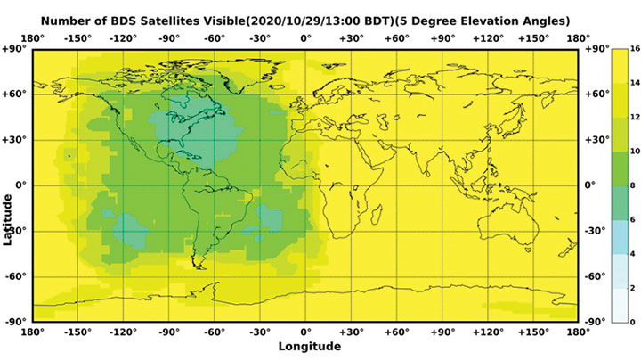
Figure 1. The number of visible BDS satellites as of BDT 13:00, Oct. 29, 2020. The number of visible satellites at Asia-Pacific Region is greater than 20. (Source: www.csno-tarc.cn)
Integrated Applications
As the system construction accelerates, BDS is also making great efforts to strengthen the development of BDS fundamental products and promote large-scale applications in various fields. The integrated applications and innovative development adopt the “BDS+” and “+BDS” models to improve quality and efficiency as well as to stimulate a healthy and fast-growing GNSS industry.
Fundamental Products. At present, the fundamental BDS products have been used in areas such as mass-market applications, where the performance has reached or is close to the world-class level. Progress has been made in the research and development of multi-system baseband-RF integrated high-precision chips. The 28 nm chips have been mass-produced, and the 22 nm chips are about to be mass-produced. As a result, the function and performance of the chips will reach a new level. The BDS navigation chips, modules, high-precision boards and antennas have been exported to more than 120 countries and regions, serving millions of users worldwide.
Industrial Applications. BDS has been widely used in various fields, including communication and transportation, public security, agriculture, forestry, animal husbandry and fishery, hydrological monitoring, meteorological forecasting, time synchronization, power dispatching, and disaster prevention and mitigation. Significant economic and social benefits have been generated.
In the field of transportation, in the first three quarters of 2020, more than 7 million road vehicles were using BDS. The number of postal and express delivery vehicles using BDS reached 314,000, and the number of ships is about 1,369. In general aviation, 300 planes are using BDS.
In agriculture, BDS-based automatic steering systems are on more than 45,000 pieces of agricultural machinery and equipment, saving 50% of the labor cost. BDS-based agricultural machinery operation supervision platforms are serving 10 million units of agricultural machinery equipment, greatly improving management and operational efficiency.
In forestry, the BDS positioning and short message communication services are widely used in forest fire prevention, natural forest protection, forest inspection, pest control and so on.
In the fishery field, BDS provides fishery managers and fishing vessels with ship position monitoring, emergency rescue, information dissemination, vessel management and other services. BDS terminals have been installed on more than 70,000 fishing boats and law enforcement vessels in China. More than 10,000 people have been saved.
For disaster prevention and mitigation, a three-level platform covering the national ministries and the provinces was built to offer six-tier application services, deploying more than 45,000 BDS terminals.
BDS plays an important role in the emergency response to major disasters such as flooding in South China and forest fire in Southwest China this year. BDS is accelerating entry into new infrastructural construction, and is deeply integrated with new technologies such as next-generation communication, blockchain, the internet of things, artificial intelligence, and more. New modes, formats and markets for BDS applications are constantly emerging.
Mass-Market Applications. BDS-based navigation and positioning services have been adopted by various enterprises in the fields of e-commerce, smart mobile terminals, location-based services, the sharing economy and people’s livelihood, profoundly changing people’s production and lifestyles. Just like water and electricity, BDS provides public services that are easily accessible and available on demand. In smartphone applications, domestic and international mainstream chip manufacturers have released communication-navigation integrated chips compatible with BDS. More than 90% of mobile-phone companies applying for access to China’s domestic network support BDS positioning. Smartphones from Huawei, MI, Apple, VIVO, OPPS and other big brands in China are BDS-enabled.
BDS Standards. The updating and upgrading of the BDS standard system is progressing smoothly, with Version 2.0 to be released soon. The BDS application standard systems will be published in electric, railway and other industries. The revision of the national BDS standards is advancing steadily. Four national standards were issued in early 2019, and 28 national standards will be released by the end of 2020. Forty-two standards related to the BDS program have been issued in three batches, while 58 new standards are being formulated.
The work related to BDS intellectual properties is being carried out, and various innovation entities continue to improve BDS’ intellectual property creation, utilization and protection capabilities. Statistics shows that Chinese GNSS-related patent applications reached 12,170 in 2019 and 9,411 by the end of October, with an average growth rate of 21.7% in the past three years.
International Cooperation
Bilateral Cooperation. BDS continues to carry out bilateral cooperation with other GNSS to promote compatibility, interoperability and joint applications. Under the China-U.S. civil GNSS cooperation platform, working groups have been set up to continuously engage in cooperation and exchanges in areas such as compatibility and interoperability, augmentation systems and aviation applications, civil service provisions, etc. China and the Russian Federation held their seventh bilateral meeting in October, and have been pushing forward landmark demonstration projects such as joint ground station set-up, cross-border transportation and precision agriculture. China and the European Union are carrying out coordination, exchanges and cooperation under the framework of the China-EU space cooperation dialogue.
Multilateral Cooperation. The BDS team participates in meetings of the International Committee on Global Navigation Systems (ICG), and continuously promotes discussions on relevant topics. The experience fighting COVID-19 using BDS/GNSS, as well as BDS applications in pandemic prevention and control, are being shared with the international GNSS community. During the ninth ministerial meeting of the China-Arab States Cooperation Forum held in July, video conferences promoted the deepening of China-Arab satellite navigation cooperation.
International BDS Applications. With the export of BDS high-precision products, BDS is widely used in different regions and fields, such as land registration, precision agriculture, warehouse logistics in ASEAN countries, construction in Western Asia, airport timing and plying the seas in South Asia, power plant inspections in Eastern Europe, and land surveys in African countries. BDS high-precision products are exported to more than 120 countries and regions. BDGAS technologies and products are systematically exported, serving more than 100 million users worldwide.
International Standards. BDS has been adopted by many international organizations including the ICAO, the International Maritime Organization, Cospas-Sarsat and mobile communication. A number of international standards supporting BDS have been released. In March, the International Electrotechnical Commission (IEC) officially issued the first international standard for BDS vessel receiving equipment inspection (IEC 61108-5), which provides the basis for global classification societies to carry out type certification of BDS equipment on vessels. In July, the first batch of 3GPP standards supporting the BDS B1C signal was officially released. The series of standards will support BDS signals in Assisted GNSS (A-GNSS) of 5G communication. By year’s end, the Radio Technical Commission for Maritime Services (RTCM) 10403.X standard, which fully supports BDS, will be officially released, marking an important milestone in the creation of a general data format standard for BDS receivers.
Adhering to the development concept of “the Chinese BDS, the World’s BDS and the First Class BDS,” BDS development vigorously carries forward the Beidou spirit in the new era — independent innovation, open integration, unity and pursuit of excellence. By 2035, a more ubiquitous, integrated and comprehensive national PNT system with a spatial-temporal information service infrastructure covering space, sky, Earth and sea, and offering unified high precision, high intelligence, high security and high efficiency, will be built. It will provide core support for future intelligent and unmanned development; continuously promote system upgrading; integrate new technologies such as new generation communication and low orbit augmentation; strive to develop high-quality capabilities such as quantum navigation, full-source navigation, and micro PNT; and build a spatial-time information service infrastructure covering space, sky, Earth and sea, with high precision, high intelligence, high security and high efficiency.
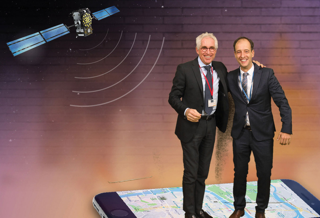
Authors Javier Benedicto (ESA), left, and Rodrigo da Costa (GSA). (Image: ESA)
Throughout 2020, the Galileo Programme under the responsibility of the European Commission, the European GNSS Agency (GSA) and the European Space Agency (ESA), has been delivering continuous and reliable global PNT and Search and Rescue (SAR) services, developed improvements to Galileo First Generation ground and space system infrastructure for increased robustness and new service capabilities, and launched a full modernization program aiming in the future at Galileo Second Generation.
The GNSS User Technology Report 2020 has just been released by GSA, providing a complete overview of the current status and trends of the GNSS worldwide market with focus on user technology and in particular European GNSS (Galileo and EGNOS) applications and services.
In addition to providing a high quality open service based on innovative signals in the E1 and E5 bands, Galileo is also the first GNSS constellation to comprise a SAR capability, including the provision of a return link to users in distress. Galileo also features unique capabilities, such as the provision of Navigation Message Authentication (OS-NMA) and of an encrypted navigation signal on E6, the Commercial Authentication Service (CAS). These functions will offer the first protection against spoofing available to civilian GNSS users.
Finally, Galileo will provide free access to a High Accuracy Service (HAS) through the use of an open data channel used to broadcast high-accuracy augmentation messages.
Performance Meeting Expectations
The Galileo constellation consists today of 22 operational spacecraft (24 satellites are available for the Search and Rescue service). Two additional satellites (GSAT0201/E18 and GSAT0202/E14) are currently under testing with regard to potential operational as auxiliary usage in the near future.
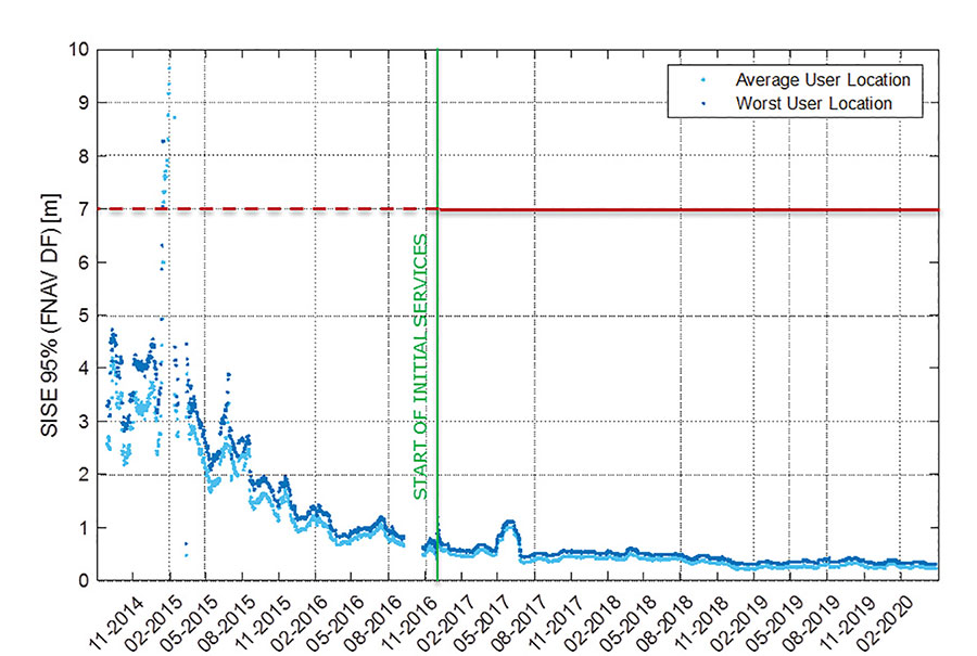
The long-term evolution of performance parameters reveals that the Galileo system is continuously improving. In particular, an excellent quality of the navigation message in terms of ranging accuracy can be observed. Since the Initial Service declaration in 2016, ranging accuracy has steadily improved reaching a level of ~25 cm (95%) by mid of 2020, see Figure 1.
FIGURE 1. F/NAV SISE as observed by user receivers (constellation average, 30 days moving average). (Image: ESA)
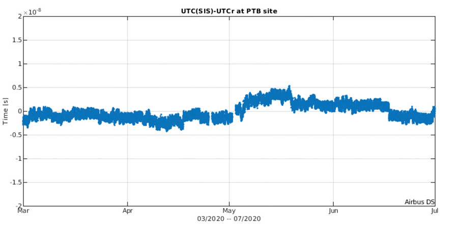
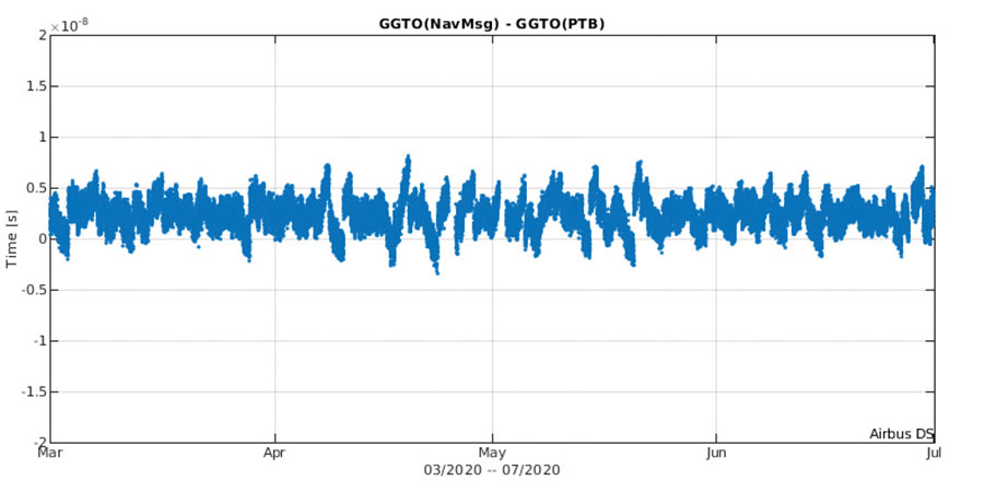
The timing accuracy benefits from the larger number of satellites in service. Figures 2 and 3 present the evolution of the UTC dissemination accuracy and GGTO accuracy performance better than 2.5 nsec and 4.2 nsec (95%) respectively, which are largely within Galileo service commitments.
Probably the most significant discriminator of Galileo versus other GNSS is its capability to broadcast multi-frequency (E1, E6, E5) signal components on all operational satellites. In the high-end and mid-range smartphone chipset market, dual frequency is becoming the norm. All large players have released dual-frequency chipsets, and the first dual-frequency chipsets targeting the budget device market are now becoming available. Dual-frequency receivers offer improved accuracy and robustness, and potential access to high-accuracy techniques. Multi-constellation is now standard for high-volume chipsets and Galileo with its multi-frequency capability is one of the largest GNSS contributors to this emerging dual-frequency PNT market.
Expanding Galileo Services Portfolio
Galileo offers the Galileo Open service (OS) for positioning and timing services, and Europe’s Search and Rescue (SAR) service contribution to COSPAS-SARSAT, equipped with its unique Return Link Message (RLM) declared operational in January 2020. Furthermore, the Galileo system is expanding its infrastructure capabilities such that, once fully operational, it will offer additional high-performance services worldwide.
Public Regulated Service (PRS) is restricted to government-authorized users for sensitive applications that require a high level of service continuity.
Open Service INAV message improvements on Galileo E1-B are under implementation, namely robust symbol level synchronization patterns, additional insertion of clock and ephemeris data with flexible outer encoding and frequent provision of shortened clock and ephemeris for improved robustness in terms of navigation data retrieval in challenging environments, in addition to facilitating a reduced time to first six (TTFF); these improvements ensure backwards compatibility with previously released OS SIS ICDs.
Open Service Navigation Message Authentication (OS-NMA) providing the free authentication of the Galileo Open Service (OS) for geolocation information through the Navigation Message (I/NAV) broadcast on the E1-B signal component.
Commercial Authentication Service (CAS), complementing the OS, providing a ranging authentication function implemented by encrypting the spreading code of the E6C (pilot) channel with a secret key. To ensure backward compatibility, CAS is based on the only civilian signal including cryptographic features (E6). When using both OS-NMA and CAS, users will benefit from data (navigation message) and range authentication, allowing PVT authentication worldwide.
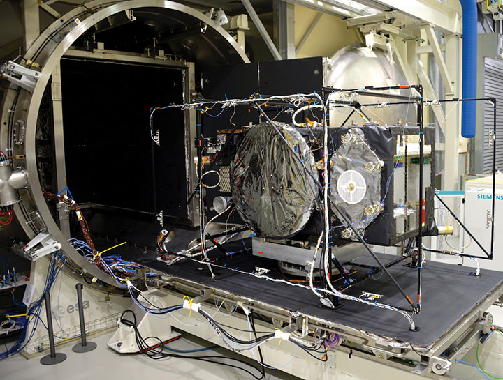
Galileo Batch 3 satellite under test at ESA’s ESTEC facility in the Netherlands. (Photo: ESA)
High Accuracy Service (HAS) complementing the OS by delivering free access high accuracy data and providing better ranging accuracy, enabling users to achieve sub-meter level positioning accuracy.
Support to Safety of Life (SoL) Services through Dual Frequency Multi-Constellation (DFMC) SBAS and supporting the provision of integrity through the concept of Horizontal Advanced Receiver Autonomous Integrity Monitoring (H-ARAIM). In this context, the Galileo Integrity Failure Mode and Effect Analysis (IFMEA) Process is implemented through measurements and review of the system design, including characterization of feared events.
Galileo Batch 3 satellite under test at ESA’s ESTEC facility in the Netherlands. (Photo: ESA)
Infrastructure Modernization
The Galileo System infrastructure is being upgraded and modernized to support the full service portfolio, provide additional robustness and resilience, ensure security and improve operations.
The Galileo Ground Segment is being upgraded implementing ground segment virtualization technologies. This modernized infrastructure will make it possible to easily accommodate technology refresh and will minimize impact to Galileo service operations, under the responsibility of Spaceopal GmbH, during future deployment activities.
Current ground segment upgrades under production by prime contractor Thales Alenia Space in France (in charge of Ground Mission Segment and Security Monitoring) are addressing the deployment of improved robustness of the navigation and precise timing solutions, the full scope of PRS service capabilities, the expansion of the sensor station and up-link ground station networks, and additional security monitoring coverage to protect Galileo ground and space assets.
Ground segment upgrades under production by prime contractor GMV in Spain are addressing the deployment of a new Ground Control Segment providing increased constellation monitoring and control capabilities up to 38 satellites, enhanced operability features, expansion of the TTC network and additional security protection capabilities.
Upgrades of the Galileo Service Facilities are underway as well, notably the evolution of the GNSS Service Center toward the integration of the OS-NMA and HAS capabilities, and the extension of the reference measurement capabilities of the Galileo Reference Centre, by the prime contractor GMV in Spain. The robustness of the SAR service operations, under the prime contractor CNES in France, is also under improvement.
The production of 12 additional Batch 3 Galileo first generation satellites is proceeding, aiming at readiness for launch from mid 2021 onward. Batch 3 satellites are comparable to the 22 FOC satellites launched previously and built by the same prime contractor OHB Systems in Germany. With Batch 3 satellites, Galileo will reach its full constellation capability, including a number of in-orbit spares.
Galileo Batch 3 satellites will be progressively launched with the new Ariane 62 launcher vehicle, the two strap-on solid booster variant of Ariane 6, currently undergoing the final stages of development led by prime contractor ArianeGroup. Meanwhile, France’s space agency CNES is preparing the Ariane 6 launch facilities at Europe’s Spaceport in French Guiana. Ariane 6 is scheduled for its first launch in 2022.
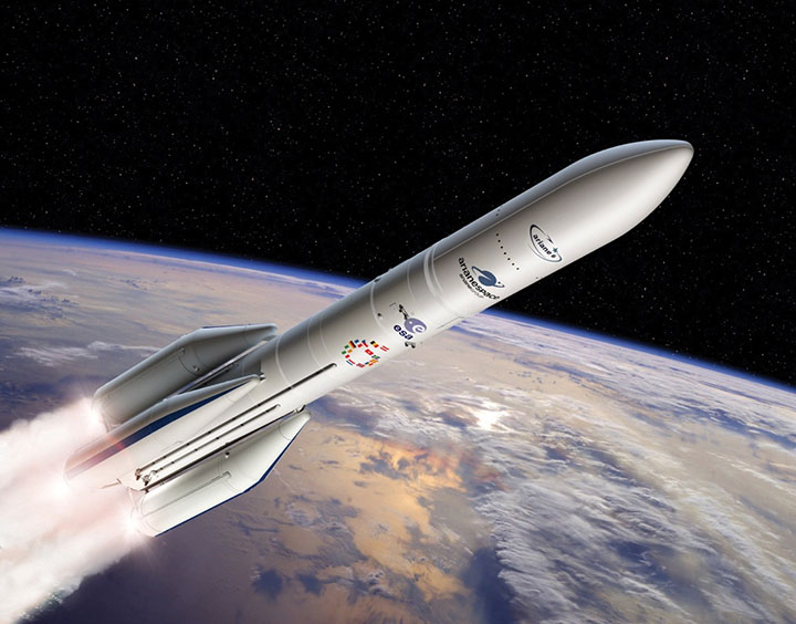
Europe’s new Ariane 6 launch vehicle. (Artist’s concept: ESA)
Toward Galileo Second Generation
The Galileo Programme is fully engaged in the process of developing Galileo 2nd Generation (G2G). Procurement activities for system, satellite and ground segment have been initiated in 2020 with the ambitious goal of starting deployment of the new infrastructure in 2024.
The design of G2G is driven by overarching principles, including backward compatibility, providing an extended portfolio of services and the quality of services, but also the absolute need to meet user demands in a timely and effective manner. The European Commission, in close consultation with EU member states, has converged onto an ambitious set of long term PNT goals for the future European GNSS infrastructures.
G2G Service Portfolio and High-Level Mission Objectives agreed with Programme Stakeholders Service include service evolutions in the areas of signals evolution for increased performance and reduced complexity and power consumption at the user receiver level, time to first-fix, accuracy, authentication and other service attributes, PRS evolutions, advanced timing services, enhanced integration with terrestrial systems (5G/6G), complementarity with external sensors (such as INS, barometer, lidar) and application environments (such as low power devices and internet of things), SAR service evolution, Emergency Warning services, Space Service Volume and Ionosphere Prediction Service.
G2G will build on advanced navigation technology developed over the past 10 years under ESA’s European GNSS Evolution Programme (EGEP) and EU’s Horizon 2020 Programme. This technological leap will allow the early introduction of novel Galileo system features:
Open service capabilities (reduce power consumption and convergence time)
High-accuracy evolution (integrity, availability)
PRS robustness and transmit power
System and SIS in-orbit flexibility, reconfiguration and time-to-market
Inter-satellite links (ranging, mission dissemination, command and control)
SAR second-generation beacons
Reduce operations and maintenance cost
Accelerate time-to-market of new services
Ground technology virtualization and modernization
Acknowledging the changing nature of user requirements, the Galileo second-generation is designed to evolve incrementally and with sufficient flexibility to provide new services or signal features, if and when required, by dynamic reconfiguration of space and ground infrastructure.