Tag: drone show

  • As GNSS disruptions rise, infiniDome moves toward mission continuity

    As GNSS disruptions rise, infiniDome moves toward mission continuity

    The rapid growth of autonomous military systems is creating a new challenge for the defense industry, working to keep equipment operating when navigation becomes unreliable.

    Across recent conflict zones and contested regions, GNSS disruption is affecting UAVs, loitering munitions, ISR platforms, maritime systems and autonomous ground vehicles.

    At the upcoming International Drone Show, infiniDome will present what it describes as an evolution of its vision.

    “InfiniDome is expanding its vision beyond GNSS protection, toward a future of mission continuity and navigation awareness in contested environments,” the company stated.

    The statement reflects a broader trend across the defense autonomy sector. While anti-jamming technologies were once treated primarily as protective add-ons, many military programs are now integrating navigation resiliency into wider autonomy architectures. The result is a growing shift in how autonomous systems are evaluated.

    Rather than focusing solely on navigation accuracy or platform performance, defense organizations are increasingly asking whether autonomous systems can maintain operational continuity under degraded or denied conditions. Industry observers note that this transition is particularly evident in the loitering munition and tactical UAV sectors, where survivability in contested environments is becoming a baseline operational requirement.

    At the same time, low-SWaP anti-jamming capabilities are becoming more common across the market, increasing pressure on companies to differentiate beyond hardware alone.
    That pressure appears to be accelerating a broader industry movement toward what some describe as “navigation awareness,” the ability not only to withstand interference, but also to understand and react to the electromagnetic environment in real time.

    International Drone Show demonstration

    The International Drone Show takes place June 3-4 in Odense, Denmark.

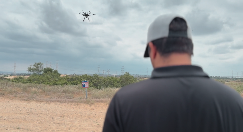
    InfiniDome is expected to demonstrate this direction during the exhibition through IroNav, developed jointly with Wonder Robotics. The demonstration will include autonomous operation streamed live from a jammed environment in Israel, showcasing navigation resilience capabilities under active interference conditions.

    The live demonstration comes as European defense programs continue increasing investments in autonomy, tactical drones, and resilient battlefield systems amid growing concerns surrounding electronic warfare and GNSS vulnerability.

  • Jammer suspected as cause of Budva drone show disaster

    Jammer suspected as cause of Budva drone show disaster

    Drones planned for a New Year’s light show in Budva, Montenegro, were deliberately shot down, according to an analysis that Croatian company Mirnovec provided news outlet Vijesti.

    Mirnovec’s owner told Vijesti the culprit used an anti-drone jammer, a gun of the type used by security forces.

    The document “GNSS RF interference analysis: Incident during a drone show,” summarizes technical findings related to a loss of GNSS navigation during the show. About 15 seconds after the launch of 600 drones from the parking lot in front of the Port Authority began, they began to return. Some drones fell into the sea and some collided with drones taking off. After 40 seconds, the operator stopped the launch. The drones fell for another 20 seconds.

    Vijesti provides details of the incident and the data gathered and reported.

  • Seen & Heard: Illegal coffee farms, Nikon camera upgrade

    Seen & Heard: Illegal coffee farms, Nikon camera upgrade

    “Seen & Heard” is a monthly feature of GPS World magazine, traveling the world to capture interesting and unusual news stories involving the GNSS/PNT industry.


    Screenshot: Global News video
    Screenshot: Global News video

    Our Spinning Globe

    A highlight of the opening ceremony at the Tokyo 2021 Olympics was a revolving globe above the Olympic stadium. The 1,824 Intel Shooting Star 3 drones formed a complex set of geometrical shapes before transitioning into the games’ emblem, and then a 3D representation of Earth. The Intel Shooting Star 3 drones are designed for entertainment purposes. Each drone weighs 340 grams, is equipped with four extremely bright LEDs, and features real-time kinematic (RTK) GPS for the increased positional accuracy needed for high-resolution animations, sharp imagery and dynamic 3D animations.


    Photo: slowmotiongli/iStock/Getty Images Plus/Getty Images
    Photo: slowmotiongli/iStock/Getty Images Plus/Getty Images

    Coffee Buzz

    Illegal coffee plantations have appeared inside Bukit Barisan Selatan National Park in Indonesia, a key habitat for the endangered Sumatran tiger and other species. Conservationist Matt Leggett noticed in satellite images the declining size of the forest, and sent a team of researchers on an undercover operation on dirt bikes with cameras and GPS receivers, reports the Aug. 11 New York Times Magazine. Leggett’s team mapped hundreds of small coffee farms and investigated the complex chain of custody, which ends with major brand names. No solution has been found, though some farmers have promised to replant the forest over the next 15 years, while others continue to clear park land.


    Hawaiian GPS station. (Photo: USGS/Jeff Freymueller)
    Hawaiian GPS station. (Photo: USGS/Jeff Freymueller)

    Now that’s heavy

    Seven scientific-grade GPS stations are joining a network of 65 that the USGS Hawaiian Volcano Observatory operates on the Hawaiian Islands. As Hawaiian volcanoes erupt and grow, they add weight to the Earth’s surface, causing the Pacific Plate to flex downward and possibly causing the shelf to splinter. Earthquakes this spring in Hawaii likely were related to weight on the underlying crust and mantle from eruptions. Collecting years of data from these stations should help scientists better understand motions of the Pacific Plate, according to researcher Jeff Freymueller, Michigan State University. The first three GPS stations were installed in May; others are being installed this summer.


    Photo: Zephyr18/iStock/Getty Images Plus/Getty Images
    Photo: Zephyr18/iStock/Getty Images Plus/Getty Images

    Camera Upgrade

    Nikon could be launching a consumer camera equipped with GNSS instead of only GPS, providing a major upgrade for the geolocation coordinates provided with photo metadata. Filings with the governments of Russia and Indonesia describe a camera dubbed N2014, which will be equipped with GNSS as well as Wi-Fi and Bluetooth. A number of Nikon CoolPix digital cameras have built-in GPS, while other cameras — Nikon D-SLRs and select Nikon 1 — can use optional accessory GPS devices.

  • U-blox positioning enables massive drone light show

    U-blox positioning enables massive drone light show

    The 10-minute-long drone show included a flying dove with a wingspan of 600 meters, visible from three kilometers away. (Photo: u-blox)
    The 10-minute-long drone show included a flying dove with a wingspan of 600 meters, visible from three kilometers away. (Photo: u-blox)

    U-blox supplied the high-accuracy technology that made it possible to fly a massive swarm of drones. The simultaneous flight of 2,198 miniature unmanned aerial vehicles (UAVs) was launched into the night sky over Saint Petersburg, Russia, on Sept. 3.

    The 10-minute-long drone show included a flying dove with a wingspan of 600 meters, visible from three kilometers away.

    Geoscan, which built and programmed the drones and ran the display, chose u-blox positioning technology for its combination of accuracy, reliability, performance and ability to access positional data from both the GLONASS and GPS satellite navigation constellations.

    The 10-centimeter-wide Geoscan Salute drones were designed for use in group flights and drone shows. The drones use u-blox NEO-M8P high-precision GNSS modules to provide the positioning data to create a fluid drone show. Salute drones return to their base stations automatically at the end of a show.

    The NEO-M8P module implements a real-time kinematic (RTK) approach that improves positional accuracy by comparing the phase of a signal being broadcast from a positioning satellite with that of the same signal that has been received and rebroadcast from a fixed base station. The accuracy gained in this way enables drones to calculate their relative positions to within millimeters, and their absolute positions to within 1 centimeter of the intended position.

    Geoscan has been producing drone displays for the past two years, starting with 40 drones flying at once. “The u-blox modules in our Geoscan Salute drones have improved our drones’ positioning accuracies to about one centimeter, and have helped reduce pre-launch preparation time,” said Semen Lapko, head of Drone Show Project, Geoscan. “Drones now move more quickly and accurately, while also operating more efficiently.”