Tag: editorial

  • Out in Front: All-Day, Everywhere for All

    We appear incompletely before you this month. A funny thing happened on the way to the presses: we discovered that we had more content than pages in which to squeeze it. “All the news that fits to print,” the motto of the New York Times, can in this instance not be ours. All the news just won’t fit!

    First to feel the axe, lamentably, was Innovation, an article on the Python receiver; you will see it in February. Also pushed to the near future is reporting on the recent Stanford PNT Symposium; it appears in the December GNSS Design & Test e-newsletter, see the website if you don’t yet subscribe. Herewith, an ultra-brief account of a presentation by Greg Turetzky, Intel. The reporters identified this paper and one on BeiDou as “harbingers of change in the industry.”

    The Turetzky paper, “Ubiquitous Location: Challenges and Opportunities of  Enabling All-day, Everywhere Location for All Mobile Platforms,” laid out the phenomenal growth of location-based services and the implications for design requirements in GNSS-wireless at the user device and silicon levels. The compound annual growth rate of GNSS devices will continue, from its current 22 percent level to a robust 9 percent for the years 2016–2022, and heading for seven billion installed units by 2022.

    From Greg Turetzky’s Ubiquitous Location paper, presented at Stanford PNT Symposium.
    From Greg Turetzky’s Ubiquitous Location paper, presented at Stanford PNT Symposium.

    Cutting to the chase, the design challenges for GNSS are to:

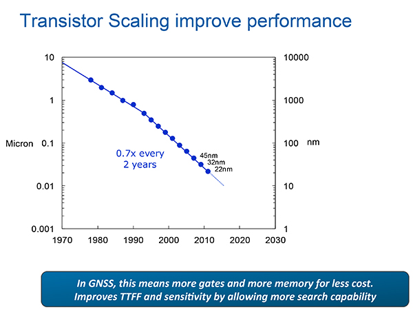
    • Take advantage of smaller geometries to achieve higher clock speeds, more memory, lower active power and smaller size, while reducing standby power from leakage;
    • Incorporate new methodologies in chip and system design; integrate multiple radios on a single die to reduce cost and size;
    • Integrate multiple radio sources into a single location solution;
    • Bring together a disparate value chain.

    The technology roadmaps embrace most modalities of positioning: GNSS, Bluetooth, Wi-Fi, cellular, and SBAS, and cross most platforms, including wearables. “We think that another, unemphasized challenge,” reporters Litton and Langenstein note, “is in the increasing density of these units with the current specifications on out-of-band emissions and the spectrum sharing and spectrum management factors in the ubiquity of the devices.”


    Tune in to our free webinar Receiver Design for the Future, with Greg Turetzky of Stanford speaking on Ubiquitous Location, scheduled for Jan. 15 (1 p.m. EST/ 10 a.m. PST/ 6 p.m. GMT). Register today!

  • Out in Front: My Heart in My Sleeve

    The next time I see Paris, I will be swinging down the boulevard in a brand new set of threads. An elegant, location-enabled set of threads that will take me by the sleeve and lead me through the City of Light.

    This wearable experiment goes by the name — of course it does — Navigate, a new line of city-specific, location-enhanced apparel. Either plug or Bluetooth the jacket (the press materials are not clear on this point) into your smartphone, download the appropriate city guide with walking tour, and start your adventure. Stash the phone in the pocket of the houndstooth jacket with red felt collar flips, no further need to look at it. Vibrations along left or right arm tell you when to turn; their frequency, intensity, and placement vary to indicate soft turn, merge, or hard turn.

    Oh, I love the colorful clothes she wears, and the way the sunlight plays upon her hair . . . I’m pickin’ up good vibrations, oom bop bop, she’s giving me excitations, oom bop bop. 

    Good, good, good, good vibrations. 

    “How we can ease the stress of navigating an unfamiliar path without interfering with the experience of discovering a new place?” asks Billie Whitehouse, design director of Wearable Experiments. “No longer do you need to hunch over a map or smartphone. Now you can experience fill-the-blank-here as a traveler rather than a tourist.” 

    Not interfering with the experience of discovering a new place: that caught my attention. In my misspent youth, I traversed the upper Amazon, the Andean highlands, and the Galapagos Islands unencumbered by a camera. To my lasting regret. I thought the device lifted to my eyes would interfere with my discovery and experience. Now I see my error. Instead of subtracting a layer of technology from my travel trunk, I should have added one. That GPS did not exist at that time, except as a gleam in young Col. Parkinson’s eye, perhaps absolves the fault in this case.

    “The skin is a vastly underutilized form of communication,” says Wear:Ex technical director Ben Moir. “Haptic vibrations are built into a full physical language, allowing the technology to communicate critical information. Technology doesn’t need to be invasive or obtrusive. It should be designed with the human at the center.”

    From signals in space to the surface of my skin. It doesn’t get much more human-centric than that. 

    Je me baladais sur l’avenue,

    Le coeur ouvert à l’inconnu.


    Also read GPS World’s December cover story on GNSS chip architecture for wearables, “The Fashion Demands of Always-On.”


  • Out in Front: Of Rats, the Mind, World Series, and Truth

    My colleague Janice Partyka wrote a provocative blog in the Wireless/LBS Insider on discovery of the brain’s inner GPS, which won three scientists a Nobel Prize for medicine. The piece struck me so forcefully in the hippocampus, locus of my location sensibility, that I was tempted to place it here verbatim. That would not justify me, however, in drawing my pay, so I add my two cents worth. Literally. Two cents worth.

    Partyka’s theme: “How does our brain understand where our body is in space, and navigate us from home to work?” She wrote that one scientist found “a type of nerve cell in the brain’s hippocampus, our short-term memory storage bin, was always activated when a rat was at a certain place in a room. As a rat ran through a maze, a particular sequence of individual neurons fired. Other nerve cells were activated when the rat was positioned elsewhere. O’Keefe concluded that these ‘place cells’ formed a map of the room. 

    “When the rats slept, the same sequences of place cells that were fired earlier in the day fired again. Researchers think that this replay helps to transfer the rat’s memory of the maze from the hippocampus into long-term storage. Place cells also attach to memories of a particular location. When sitting at a table, a person or maybe even a rat might remember a pizza that was eaten at that spot. 

    “Many decades later, the Mosers discovered another component of the brain’s positioning system. They identified ‘grid cells,’ which are thought to act like a dead-reckoning system and generate a coordinate system to allow for precise positioning and pathfinding. The grid cells create a location to put place cells and organize position locations. Rats running around an open floor (hopefully not mine), will fire neurons that map out a grid of equilateral triangles that serve as a spatial map. Grid cells can function in complete darkness, without visual cues. Together, place and grid cells make it possible to determine position and to navigate.

    “While place and grid cells were first discovered in rats, studies using brain imaging indicate that they also occur in humans.”

    As I sit here in mid-October listening to the World Series (for some deeply buried irrationality, sleeping in the Americana of my mind, I believe that baseball is better on radio than on TV), I visualize the athletes lunging and spearing and leaping about the field of play, barely having to look because they know the cells and grids of it so well. They just react to the ball and — smack! — it arrives in the first baseman’s glove. And what of the pitcher, who knows the strike zone so totally, so certainly, so inwardly, at 60 feet’s distance from his outstretched arm, that he can navigate a small spheroid precisely, on a curved path no less, to its lower left corner?

    Technology enhances our sense of location, as we in particular know so well. But technology can be fooled, perhaps more easily than the brain. Could the brain be convinced that its body was speeding towards Libya when in reality it placidly cruised northward in mid-Adriatic? Imagine how your brain would fare against the spoofer in this issue’s cover story. 

  • Out in Front: Curing Cancer

    Out in Front: Curing Cancer

    source:  global.
    Source: Cancer Research UK.

    As in, “It’s not like you’re curing cancer,” a refrain I hear sometimes when I get a bit over-inflated on GPS/GNSS and the wonders they can do in many fields of human endeavor. The intent of that remark is to remind me that on the one hand, there is technology. On the other hand, there is life, and there is death. Despite the leaps and bounds and the many alterations to life and its circumstances that technological advances have created, life — and death — still have the upper hand. And they will for the forseeable future. What’s that bumper-sticker saying? “Nature bats last.”

    At the crux of the mystery of life and its endings is the nature of cancer, one of the leading causes of the end of life. Cancer is so deadly because cancer cells are immortal. They multiply endlessly, unlike normal cells that have a limit of about 30 times multiplying-and-dividing. Cancer cells take over the host body until they have crowded out enough normal cells to kill it. The cause of death in this case is . . . immortal life.

    Some believe that the key to immortality, if not to perpetual youth, lies hidden inside the coding of cancer cells, and that in unlocking one mystery, we may succeed in unlocking two. But I’m treading on thin metaphysical ice here, so I’ll withdraw to the solid shore of what we do know, of what we know we know.

    One of these known facts is that, yes, GNSS will not cure cancer. But it can be useful in the fight. See our special coverage, which appears in the October issue.

    The first successful forays have come in the field of geographic information systems (GIS); as yet, the insights furnished by GIS are not down to the level of accuracy furnished by GPS/GNSS, but they will surely get there. And GPS itself has been employed to study the recovery rates and health issues of cancer patients, indicating further usefulness.

    It’s all part of the fabric. The solutions lie at the heart of the mystery.

  • Out in Front: 25 Years Young

    Alan Cameron
    Alan Cameron

    When I was a young man, the moment seemed like all there was, all there needed to be. Why plan? Why reflect? The days were just packed.

    Once I turned 25 — or somewhere around there — intimations dawning of my own mortality, I began to look both forward and back. It seemed like a good idea, perhaps even an important one, to draw from my own history, good and bad, and use that perspective to start building a more informed, more mapped-out future.

    That’s what the Special Section accompanying this issue is all about. So much goes on at all times — the days are just packed — and we are so busy formulating solutions to the challenge of the moment, whether that be spoofing or indoor positioning or adjacent-band use, that we have little opportunity to reflect on how far we have come. To take the long view on just where we want to go in the next 25 years.

    In that vein, we are proud to present Brad Parkinson’s vision of the future. He brought you GPS in the past. He has his sights firmly fixed on “PTA” for the future: Protect, Toughen, and Augment GNSS to assure continuous delivery of solutions. 

    Brad is uniquely qualified to lay out these prescriptions for our collective future. Having been deep in the political and technical trenches, fighting to build a revolutionary new system decades ago, and in continuous engagement ever since, he knows both the vulnerabilities and the possibilities.

    No mention of the 25-year history of this magazine would be complete, or even remotely accurate, without giving prominence to two individuals who shaped it from the beginning.  Glen Gibbons was the founding editor and held down this chair for 16 years. He literally invented GNSS journalism. His confrère from those early days is still with us: Richard Langley logged his 200th Innovation column a couple of years ago, and it remains a cornerstone of every issue. Except August and December, when he helps us compile the GNSS Constellation Almanac.

    So, back to the young man, 25 years of age, who had a head full of impressions but not much, perhaps, in the way of concrete ideas. He has turned twice that number since then, and I hesitate to state how many more. The impressions, of course, have only continued to accumulate. The ideas have started to come. Plans have formed, been left by the wayside, new plans derived, and some of them even followed. Life, it has been said, is what happens while you are busy making plans.

    Take some time to wander through the back pages of GNSS industry history in the Special Section volume that accompanies this one. Read what the GPS Directorate is doing now to make things even better. Absorb the necessary strength and vision — Dr. Parkinson’s PTA prescription — we’ll need for the future.

    And then go out and do 25 more.

  • Out in Front: The State of Our Union

    Out in Front: The State of Our Union

    JEFF FEHLBERG, winner of the drawing for a Trimble Juno T41, grand prize in the 2013 State of the Industry Survey. You, too, can be this lucky!
    JEFF FEHLBERG, winner of the drawing for a Trimble Juno T41, grand prize in the 2013 State of the Industry Survey. You, too, can be this lucky!

    Like Olympic athletes, doctors without borders, and magicians, members of the GNSS community constitute an informal international group that gathers periodically, in different centers around the world, to share knowledge and advance their craft. It is due and fitting, perhaps even necessary, that we also try to summarize or collect our views about ourselves, our field, and our future. The State of the Industry Survey is an effort to do just that.

    Last year’s Survey drew 893 responses from I lost count of how many countries; the results were published in the September issue. The questions for the 2014 Survey appear on the pages immediately following, and the online interactive Survey is now live, through the end of August. You can win cool stuff simply by answering 20 questions.

    Displayed here are last year’s top prize winners. Jeff Fehlberg, a mobile business analyst from Tritech Software Systems in Little Rock, Arkansas, garnered the rugged handheld Trimble.  

    John Zittere of Engility Corporation in Hollywood, Maryland, sent along a selfie with giftie, and a few comments: “I really do enjoy reading GPS World and I also suggest it to our new-hire engineers. Here are a few pics from our Automated Aerial Refueling tests in Niagara, New York (see below).”

    JOHN ZITTERE with his dinner ticket, the second raffle prize from the 2013 survey.
    JOHN ZITTERE with his dinner ticket, the second raffle prize from the 2013 survey.

    Also receiving gift cards for completing the 2013 Survey: Jinghui Wu of  Kensington, New South Wales, Australia; Dr. S.M.A. Rizvi from Aligarh, Uttar Pradesh, India; and Rui Barradas Pereira of GMV in Lisbon, Portugal.

    CALSPAN Lear Jet with the probe (non-functional but flight ready).
    CALSPAN Lear Jet with the probe (non-functional but flight ready).
    AAR016, view of the tanker drogue from the Lear Jet.
    AAR016, view of the tanker drogue from the Lear Jet.
  • Out in Front: Epic Fail

    Sometimes the patient has to get sick in order to get better. The eruption of a malady leads to identification of an underlying condition; appropriate treatment can then be devised to cure the body of its ills. Sound like House, M.D.?

    As a variant on this plot line, the patient can know full well what is wrong deep down inside, but refuses to acknowledge or deal with it. As in, “I’ll stop smoking when I start coughing,” or “My drinking hasn’t gotten to the problem stage . . . yet.”

    Let us examine the patient GNSS. The April signal outage, system-wide on the GLONASS constellation, lasted less than 12 hours. That was long enough to cause consternation for end users around the world, and for several voices to renew their calls for multi-constellation GNSS and alternative PNT. The interruption was also short enough that it has now vanished from most rear-view mirrors. Everything is back to normal and everyone can go about their business.

    But the patient is still unhealthy, and vulnerable.

    It is easy enough to fault the system operators, who after all are only human, and to say, “That can’t happen here. We have enough safeguards in place. And our guys and gals are just that good.” In other words, we take enough antibiotics and are generally, you know, well, healthy. As healthy as anyone else.

    We have yet to see a full-scale jamming or spoofing attack on the order of cyber-security breaches in other targeted areas that have made off with millions or billions of dollars.

    We have yet to experience a truly major-league Sun event, when global circumstances would be in dire need of PNT help just when GNSS was least helpful.

    We have yet to encounter some other unknown, unexpected event or environment that will reveal in painful detail the vulnerabilities of GNSS.

    Which are well known to us at this writing.

    This month’s cover story on a new enhanced differential Loran technique represents one arm of geospatial-medical research. Notably, it evinces little concern for GLONASS, the area where the latest malady erupted. No, the Dutch harbor pilots are concerned about over-reliance on GPS, the Gold Standard. The Gold Standard! What could possibly be wrong with the Gold Standard? After all, it’s golden.

    GPS III Misses Delivery Date. The U.S. Air Force is shopping for alternative companies to make future GPS III satellites after the first eight birds come through. Current contractor Lockheed Martin Space Systems missed a 2014 delivery date because, although it has three satellites in the production barn and a satellite test-bed vehicle that has successfully passed system tests, it has received no payload from subcontractor Exelis to put aboard same.

    Delivery of the first GPS III satellite is now expected to slip from fiscal 2014 as far as fiscal 2016. Then there’s launch to consider, which brings to mind the launch budget and schedule, annually trimmed back by Congress. Then there’s OCX, needed to operate GPS III, also struggling to stand up.

    Even once established, GPS III will share the same vulnerabilities of current GNSS.

    The doctor looks worried.

  • Out in Front: How Much Farther?

    For some years now, we have been talking about GNSS interoperability. The concept has received so much careful attention at conferences, in R&D laboratories, in international working group forums, and behind closed high-level government and military doors, that one might understandably conclude that we have talked interoperability into existence.

    Not quite. Not nearly. Not by the farthest, if measuring into the next decade constitutes far, reach of our actual, real-world grasp.

    “If you can imagine it, you can achieve it.” William Arthur Ward, a professional inspirer of the 20th century, said that.

    For nearly as many years now, we have been talking about GPS and GNSS backup. Similarly, the concept has undergone careful examination and much repeated (’til blue in the face) urging and warning and alarum-
    sounding and planning and conjecturing and running through the halls of Congress. One might understandably conclude that we have conjured backup for critical infrastructure into actual, tangible, effective existence.

    Again, not quite.

    “Everybody talks about GPS backup, but nobody does anything about it.” Mark Twain said that.

    April’s GLONASS downfall prompted distinguished industry leaders to again take up cudgels for multi-GNSS and for redundant PNT. They deserve and require our support, on all fronts, whether in the public arena, the lab, or the marketplace. But neither concept yet exists, truly and pervasively, that is to say effectively for all users.

    When will reliable, robust, consistent and continuous positioning, navigation, and timing become a reality?  Should we rely on whatever technology we currently possess until the perfect system comes available, or should we continuously upgrade at each iterative step along the way?

    We take up this topic in our June 5 webinar, “How Much Farther to the Promised Land? Purchase Decisions in the Evolving Landscape of GPS, Multi-GNSS, and Alternative PNT.”

    Four speakers will present:

    • a high-precision GNSS manufacturer,
    • a mass-market GNSS manufacturer,
    • an alternative PNT provider,
    • a design and manufacturing firm,

    followed by questions from you, our audience. Come for a glimpse into the future, and estimations of its distance and time of travel from current location.

    Among the key insights: technology changes too fast to wait until the next generation of a product to add new capabilities, when doing so risks loss of competitive edge or, worse, risks introducing a new product already obsolete. A mid-lifecycle component change can deliver both greater performance and cost savings. For details on this prior to June 5, visit the White Paper section of our website.

  • Out in Front: Europa, Europa

    Not so long ago, we occasionally speculated on the order of GNSS preference for both manufacturers and end users. GPS first, of course. Only the most radical of future visions saw anything different. But after that? GLONASS, Galileo, BeiDou — or switch them around? A case could be made for almost any sequence, by virtue of active constellation size or geometry, code structure, interoperability, government funding, or national economies.

    It was once felt that a maximum of two GNSS could be made to fit cost-beneficially on a chip destined for mass-market devices; professional OEM boards had, of course, far more leeway and budget. Then engineering ingenuity found space for three on a chip.

    A wag noted during that timeframe that in GNSS as in the Olympics, one can win gold, silver, or bronze. There is no prize for fourth place.

    Lately, however, it seems there may be room for all. Our feature article this month affirms that “the silicon manufacturer must continue the path towards the fully flexible multi-constellation mass-market receiver.”

    Nevertheless, choices will be made in design and manufacturing: different choices by different manufacturers in different regions, on different products. I now think that market size and connectivity will be the strongest drivers for selection of GNSS in product design. Constellations, at least in their order of establishment, almost don’t matter. Government mandates to use the respective national (or regional) GNSS in official or officially linked applications will add to the weight of market size.

    These government-mandated applications encompass air, rail, and maritime navigation and management, survey and construction, road tolling, and road-user charging, just to start with. With emergency calling, it’s not hard to envision such mandates extending to telecomm as well, the most plentiful in end-user devices.

    In that light, consider the words of political scientist John McCormick from his book Why Europe Matters.

    “The European Union has a population of more than half a billion. It is the wealthiest marketplace in the world, is the biggest trading power in the world, is the biggest source of (and magnet for) foreign direct investment, and has shown that it is possible to wield influence without relying on military power.”

    Even should Galileo finish fourth in the race to establish a full constellation, smart money may put Galileo on every future GNSS chip, high precision or mass market.

  • Out in Front: Who’s Been Mining My Location?

    Out in Front: Who’s Been Mining My Location?

    Conventional wisdom holds that smartphone users will tolerate diluted privacy — specifically, privacy of their own location — in return for the many advantages delivered by the location-based services on their devices. This conventional wisdom, I put it to you, has been disseminated over the years by conventional wise men, that is, those selling the services and the devices. Users themselves have not, in the full awareness of their situation, been sounded or heard from. Now murmurs bubble to the surface.

    Five researchers at Rutgers University recently published a paper, “A Field Study of Run-Time Location Access Disclosures on Android Smartphones,” based on work supported by the National Science Foundation. The paper describes how they created an application to inform users which other apps are mining their GPS location data, and then asked users how they felt about this.

    Participants took various actions to manage their privacy. These included uninstalling apps, stopping the use of some apps, reducing the time using some apps, and searching through apps’ setups to disable location accesses.

    “[They] appreciated the transparency brought by our run-time disclosure method,” the researchers state. “They wanted to continue receiving the notifications after completing the study. Most participants reported having trade-offs between location privacy and the convenience of using their apps. We observed that some participants would rather give up the convenience to protect their location privacy.”

    First, the researchers had to figure out how to provide the information to project participants; in other words, how to let them know who was watching them and tracking their movements?

    “[Although] there is no obvious way for a normal Android app to monitor whether other apps are accessing location, we discovered we could exploit the method getLastKnownLocation available in the Android Location API for this purpose.”

    Participants — those in the know, at least — described the study as “an eye opener.” In one of the most telling details, delivered in the paper’s last sentence, we find out why. The study encompassed two groups: one was shown that other apps accessed their data, and the other group was only informed of this after the project was completed. “The No Disclosure group were generally not aware of what was happening on their own phones.”

    Caveat orator.

    Steve Copley, GPS World publisher.
    Steve Copley, GPS World publisher.

    In other news, I am happy and proud to announce that former associate publisher Steve Copley is now full-on publisher of this magazine. After a year in the traces (or should that be trenches?), Steve has ably reinvigorated business aspects of the operation, cleaned house, kicked buttstock, and taken names. It is due and fitting that he now tackle further challenges.

    As I shall also, in my new role of group publisher. While continuing to do what I do, my purlieu extends more fully over geographic information systems and Earth observation, as well as new initiatives in the European market. Specifically, the new EAGER newsletter, the EuropeAn GNSS and Earth Observation Report.

  • Out in Front: Complements of the Season

    Alan Cameron
    Alan Cameron

    In the wake of last month’s Expert Advice column on eLoran — “The Low Cost of Protecting America” by Dana Goward of the Resilient Navigation and Timing Foundation —  come several positive comments and encouraging developments. Rather than rehearse all the arguments why we should care about this, I’ll repeat the one word that I heard most often in GNSS circles in 2013: jamming. Followed closely by: spoofing.

    “I have been advocating strongly for reconsideration of the government’s domestic Loran decision for the last year or so,” writes one reader positioned on Washington’s Beltway, “and specifically working within the Department of Defense (DoD) to ensure it is aware of international developments for eLoran in the UK and South Korea, and the possibilities inherent in other former Loran chains.

    “The DoD is beginning to recognize the value of eLoran as a complement to GPS, not only for international missions, but in cooperation with the departments of Transportation and Homeland Security for domestic critical infrastructure.”

    Last fall, Don Jewell’s Defense PNT newsletter on the same subject drew this reply from another well-known expert:

    “One of the key short-term actions is to prevent the decommissioned [Loran] sites from being sold off for subdivisions. These sites are a national treasure with unique properties: soil conductivity, water content, metal content, and more that are hugely important in siting low-frequency positioning systems. Those long-gone engineers of the 1940s and ’50s knew this and chose accordingly.”

    Before last month’s issue appeared but after it had gone to press, President Obama signed the National Defense Authorization Act (NDAA) for 2014.  It contained several favorable New Year’s auguries for positioners, navigators, and timers.The act evinced an acute awareness of the vulnerability of space systems to disruption. The act is also a law governing the land. Through it Congress requires the administration to, among other things, explain biennially in its “Space Protection Strategy” report exactly how, in the event space systems are disrupted, DOD and the intelligence community “plan to provide necessary national security capabilities through alternative space, airborne, or ground systems.”

    Since said administration acted early in its first term to decommission Loran-C, the congressional directive is pointed.

    The next big thing coming up on the GNSS international horizon takes place in Rotterdam, the Netherlands, April 15–17: the European Navigation Conference, ENC-GNSS 2014. It includes a track session on “eLoran and other Low-Frequency Systems,” and I’ll be there with pencil sharpened.

    Brad Parkinson will give the ENC keynote, and he is on record as one of an august group of Institute for Defense Analyses experts who unanimously recommended that the existing Loran-C be greatly updated and modernized to eLoran. We should hear more from him on this subject amid the wharves, waterways, and docks of Europe’s largest port (world’s third busiest).

    There’s barely room left to report the successful tests of Enhanced Differential Loran (eDLoran) by Dutch specialists Reelektronika: absolute accuracy of 5 meters in the North Sea and in the Rotterdam Europort harbor area.

  • Out in Front: Above All, Leadership

    Out in Front: Above All, Leadership

    GPS Summit 2002 award.
    GPS Summit 2002 award.

    Just took a stroll down memory lane, leafing through the pages of the December 2002 issue of this magazine. They contain predictive essays of that era — Directions 2003 — and a transcription of the panel discussion from the very first Leadership Dinner, then called the “GPS Summit.” I was there, running the door, riding the audio recorder, handing out bronze presenteaux (pictured here) to departing guests.

    We have carried on the tradition of that event, the brainchild of Glen Gibbons (whose December 2002 editorial headline I have repeated here) and Richard Fischer, nine times now. We carried the show, innovating as we go, from Long Beach to Fort Worth to Savannah, back to Portland and thence to Nashville. We shall convene again in Tampa next year. We’ve had spirited debates, campaigns and elections (the Satellite Party versus the Signal Party), a history of GPS origins from Brad Parkinson himself, a recognition of the pioneers from the early era who built the system from scratch, a Grand Game of GNSS negotiation and trading, horse racing, physics trivia, and this year, a spoofing simulation (see the back page of this magazine).

    Somehow amid the fun of each occasion, we managed to squeeze in a healthy dose of thought leadership. This year’s installments you will find on pages 28 to 49, including dinner remarks from the four recipients of this year’s Leadership Awards, and essays by upper-level if not the top-level executives at each of the four GNSSs.

    For added perspective, see these excerpts from the 2002 discussion high atop the Portland Hilton.

    Javad Ashjaee (then CEO and president of Javad Navigation Systems): “There is no end to the enhancement that we can do in signal processing, assuming that Intel and others will not stop giving us the tools that we need. As you see, the front line of this is microprocessors.”

    Kanwar Chadha (then founder and vice-president of marketing at SiRF Technology): “As far as the consumer is concerned, it comes down to what they are buying, and what’s the value proposition. I can tell you from personal experience, it’s not purely a technology decision.”

    Steve Moran (then director for civil space programs at Raytheon, where he still works as director, GPS mission solutions): “We manage a positioning and navigation system, rather than a positioning and timing service — and that’s a fundamental change that needs to come about in the way we look at GPS.”

    Bob Denaro (then vice-president and general manage at NavTeq): “One day soon we will have digital paper. A map with high-resolution addressable data on what looks and feels, and most importantly, costs like a sheet of paper. My position shows up as a bright spot moving along the paper as I move.”