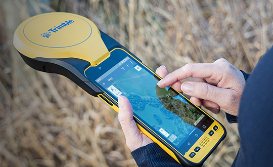
Trimble has announced a new high-performance data collector for its Mapping and Geographic Information Systems (GIS) portfolio — the Trimble TDC650 handheld. Built for GIS data collection, inspection and asset management activities, the TDC650 provides users a rugged solution with scalable high-accuracy GNSS positioning for professional field workflows.
The TDC650 is fully integrated with today’s demanding GIS data environment, powered by the Trimble Software Development Kit (SDK) that enables precision GNSS positioning for apps such as Esri ArcGIS Field Maps and Trimble TerraFlex software. The TDC650 is also a scalable solution that allows customers to choose their desired accuracy down to the centimeter-level to meet needs and budget requirements.
“This is an ideal tool for customers tasked with modernizing critical utilities including electric, gas and telecommunications networks,” said Gareth Gibson, marketing director, Trimble Mapping and GIS. “The precision, quality and data integration workflows needed to map the physical world to a digital one in these projects requires a modern data-collection platform like the TDC650.”
City, state and local governments and utilities will benefit from this solution, which is part of the larger Trimble Public Sector ecosystem that includes Cityworks software for stormwater inspections and Trimble Unity for monitoring municipal water pressure and hazards. As GIS data continues to grow more complex, Trimble helps simplify, visualize and make sense of the data so customers can make better decisions in managing their communities’ assets.
Eos Locate for Collector combines three core technologies: Eos Arrow GNSS receivers, Esri Collector, and the Vivax-Metrotech vLoc Series of locator devices.
With Eos Locate for Collector, one field worker can collect both GNSS locations and locator data (such as depth below cover) for any buried asset including water, sewer, electric, cable, gas, fiber infrastructure and more. They can do so quickly, accurately and without the need for any additional field or office support.
“We are giving our Arrow GNSS customers a solution today that allows them to combine both locator data and high-accuracy locations in web maps,” Eos CTO Jean-Yves Lauture said. “This greatly simplifies their workflow by allowing one person to do underground locates and GIS mapping simultaneously.”
“This is a big step forward for utility organizations who need to gain better visibility of their infrastructure,” said Doug Morgenthaler, Esri program manager. “With today’s technology, utilities can already see where new assets are being put in the ground. The challenge historically has been figuring out where existing assets are.”
Eos Locate for Collector not only streamlines underground-asset mapping, but also improves office production times. It eliminates the need to manually combine datasets from the locator and GPS devices within ArcGIS.
“Seeing all that information from utility locators and GPS receivers packaged directly into a GIS application is exceptional,” Vivax-Metrotech Eastern Regional Sales Manager Kelvin Cherrington said. “This solution will help utilities create maps of their underground assets with a much more modern and efficient methodology.”
Indiana American Water Early Adoption
Earlier this year, Indiana American Water approached Eos to seek a solution that consolidated their utility-locate workflow with their Arrow and Collector field work.
“We had the manpower to put paint down,” said Todd Chapman, Indiana American Water Senior GIS Analyst. “But we would need to hire another person to map the locations with our Arrow Gold GNSS receivers.”
Chapman estimates Eos Locate for Collector will cut their field time in half as well as enable the creation of extremely accurate buried-infrastructure maps in ArcGIS.
“Previously, we were seeing that our old water mains could be off by up to 20 feet,” Chapman said. “With the new Eos Locate for Collector, we’re seeing that it’s accurate to under an inch.”
The initial release of Eos Locate for Collector runs on Apple’s iOS iPhones and iPads and supports the vLoc Series from Vivax Metrotech. Future releases of Eos Locate for Collector will support additional locator models including the vScan series.
With accurate digital twins of their buried infrastructure, utilities across sectors can expect improvements to safety, damage prevention, field efficiency and regulatory compliance.
“Not only does this mean quicker responses to 811 tickets and fewer liabilities during field digs,” Lauture said. “But it also constitutes a major step forward toward the highly efficient future of 3D asset management and viable augmented-reality workflows.”
New utility network management extension combines advanced system of record with location-based analytics.
Esri, the geographic information system (GIS) technology and spatial analytics company, is releasing advanced network capabilities for utilities as part of the company’s ArcGIS platform.
The ArcGIS Utility Network Management extension, which delivers the new utility network, lets users create, manage and share complete data about networks from source to demand, such as residential meters for electric, water, wastewater, gas, district heating and telecommunications companies.
These network management capabilities enhance Esri’s current utility platform for handling billions of data elements while providing access to the utility network on any device, anytime, anywhere. For the first time, workers will be able to edit and trace the path of a network from a smart device while in the field and share information securely and more easily with those who need it. Previously, each utility subnetwork — like transmission lines, substations, and distribution and low-voltage networks — had its own separate GIS database.
The utility network provides a holistic system for every component of the utility supply chain right down to the customer, as well as the ability to store unprecedented detail on each of these components, which will be very important as utilities evolve to provide higher fidelity information to operational systems.
“We are very excited about the release of our next-generation utility platform,” said Jeff Rashid, Esri global director for utilities and communications. “These advanced capabilities will help utilities and telecoms provide greater details about their networks across their organization, at a rate of speed not seen in the past.”
The ArcGIS Utility Network Management extension allows the utility network to be completely cross-platform capable, meaning it is not confined to users of desktop GIS software. Before this innovation, location data was not easily accessible for fieldworkers or executives, managers, service technicians, and accountants who needed to have accurate, real-time understanding of utility assets.
In addition, Esri partners in the utility field will be able to use this network to add greater value to their workflow, create new solutions allowing personnel to be more efficient, and to better satisfy the needs of their customers.
“We are excited about the new capabilities in Esri’s utility network management platform and look forward to evolving the ArcFM Solution XI Series to offer utilities unprecedented value,” said Jay Stinson, general manager, Schneider Electric Geospatial Business. “This next generation platform enables us to build a world class ecosystem for managing the design and construction workflow. The continued strength of the historic Esri and SE partnership will help utilities realize the full potential of their GIS investment, equipping them to address the challenges facing today’s digital utility.”
A pair of companies is using unmanned aircraft systems (UAS) for powerline construction.
Sharper Shape, a drone-based automated inspection provider, and SkySkopes, a professional UAS flight operator, took on a project in cooperation with an investor-owned utility.
Photo: Sharper Shape
The mission used the Sharper A6 UAS to string sock lines for a 675-kilovolt line construction project.
Sock pulling, the act of flying a strong and lightweight rope and attaching it to the towers, is typically performed via helicopters or by workers climbing the towers.
Both these methods involve risk to both helicopter pilots and ground crews. The use of UAS is eliminating the previously complex process — consisting of several steps of reattaching the rope — and decreasing the risk of injury for people involved.
The mission highlighted how UAS are a safe and effective option for many applications in the utility industry beyond basic inspections, according to Matt Dunlevy, CEO and president of SkySkopes.
“This is a great proof of concept for unmanned aircraft because we proved that they can string both the outboard lines and the center line through the middle of the center phase of a tower,” Dunlevy said. “There are risks associated with both helicopter and tower climbing methods. Now there is another option as proven by Sharper Shape and SkySkopes.”
Photo: SkySkopes
“When the utility first reached out there were lots of unknowns,” said Paul Frey, director, electric utilities for Sharper Shape. “Working as a team, we pulled together, developing a test plan and executing the flights.”
The team modified a heavy-lift small UAS to carry line, and then ran five test flights to test objectives related to pulling the line through each of the tower phases and setting the line on the center pulley.
SkySkopes’ pilots are trained for difficult missions, often flying advanced heavy-lift multi-rotor aircraft with precision where autonomy is impractical.
NASA’s UTM. On May 25, the Federal Aviation Administration (FAA)-designated Nevada UAS Test Site and its NASA partners flew five different unmanned aerial vehicles (UAVs) to test NASA’s Unmanned Aircraft System Traffic Management (UTM).
The flights demonstrated multiple operational scenarios, including parachute-initiated emergency supply deliveries and aerial survey operations.
The UAVs were flown beyond the pilot’s visual line of sight (BVLOS) using strategically placed visual observers and sophisticated command and control, communication and detect-and-avoid technologies.
The test is part of a three-week national campaign, which NASA is leading in close collaboration with the FAA and industry partners on a more complex version of its UTM technologies at six different UAS Test Sites around the nation.
Demonstration in France. In France, Delair-Tech flew a UAV for 30 miles, simulating powerline inspection. Delair used a regular, commercial 3G cellphone network to control the drone for the test — an innovative demonstration that long-distance drone operations can be safe and simple to achieve.
Canadian Deliveries.Drone Delivery Canada Corp. (DDC) hit a pivotal milestone toward commercializing its drone logistics platform after achieving BVLOS in test flights. Systems tested include DDC’s FLYTE management system, avoidance technology and communications platform.
During flights in Alberta, DDC’s Mission Control Centre in Toronto, 2,500 kilometers away, successfully monitored and record telemetry in real time. DDC could become the first drone logistics-compliant operator approved by Transport Canada.
Avineon Inc. has launched a new portion of the Avineon Innovation Lab dedicated to articles, white papers and videos highlighting the impact of Esri’s Network Management System in the ArcGIS Platform. Avineon is a provider of geospatial, information technology and engineering support services.
The new section focuses on Avineon’s contributions, expertise and partnership with Esri on the next evolution of GIS Network Management: the Utility Network.
Part of the ArcGIS platform, the Utility Network is available on any device.
GIS services and solutions have been a part of Avineon’s success for the last 25 years, which is keeping pace with evolving technology and the impact GIS has on companies in the utility and telecommunications industries.
The Utility Network lets users create, manage, and share electric, water, wastewater, gas, district heating, and telecommunications asset data. The beta release of the Utility Network comes with base data models for electric, gas and water networks.
The technology is capable of supporting other networks — such as district heating, telecommunication and wastewater — but, for now, users need to build their own data models or rely on partners. Esri will provide base data models in some of these areas in later releases.
“Avineon has been a valuable partner and contributor to Esri’s Utility Network throughout the early adopter program, providing valuable feedback to our product teams,” commented Bill Meehan, Director of Utility Solutions for Esri. “The resulting Network Management System in the ArcGIS Platform will support utility and telecommunication companies as they execute their business plans for innovation, digital transition and transformation, sustainability, and smart ecosystems (smart grid, smart buildings, smart transportation, smart cities, etc.). We believe Avineon’s partnership with Esri and offerings like Avineon’s Head Start program, as well as observations into the practical applications of the Utility Network, through their Innovation Lab, will help industries understand the strategic and tactical pathway to maximize the value of their GIS now and into the future.”
Joel Campbell, Avineon’s vice president of Commercial Systems, added, “As an Esri business partner, it is exciting to support our customers and contribute to Esri’s vision of the ArcGIS Platform. These new capabilities serve as the foundation for delivering a new generation of business applications leveraging web and services patterns as well as evolved network management capabilities. We at Avineon look forward to utilizing our Innovation Lab as an outlet to share the lessons learned, best practices, and case studies around the newest evolution of GIS and its impact on the utility and telecommunication industries.”
Organizations work together to fight cyber attacks with innovations to visualize threats.
Esri and the U.S. Department of Energy’s Idaho National Laboratory (INL) have entered into a cooperative research and development agreement (CRADA) to collaboratively research and create prototype concepts with a specific focus on location intelligence solutions for the protection of critical infrastructure and critical missions.
The work will also estimate the impacts on critical infrastructure caused by exploited cyber vulnerabilities and targeted attacks.
Esri provides geospatial analysis and visualization capabilities across infrastructure industries like water, electric, oil and transportation, as well as in support of federal, state and local governments charged with the mission of protecting those industries.
These capabilities, combined with INL’s knowledge and capabilities for securing these systems from physical and cybersecurity threats, make this cooperative research and development effort truly unique in addressing crucial gaps in cyber/physical analysis and situational awareness technologies.
INL is the nation’s leading center for nuclear energy research and development, working in energy, national security, science, and the environment. Esri and INL have worked together for more than three years.
“We are looking forward to working closely with INL in this capacity,” said Brian Biesecker, technical director, Esri intelligence community. “As the government continues to embrace new technologies, CRADAs provide a great way for private and public partnerships to continue moving our country forward.”
Drones could soon be inspecting powerlines in India, thanks to a partnership between Sharper Shape and Sterlite Power.
Sharper Shape, based in Palo-Alto, California, offers automated drone-based asset inspections. Sterlite Power is a power transmission company in India.
The Sharper Shape Sharper A6 drone is designed for beyond-visual-line-of-sight (BVLOS) flights.
Sharper Shape has already spearheaded the adoption of long-distance commercial drone flights for utilities in Europe. In the U.S., Sharper Shape is part of the EEI Sharper Utility partnership, an industry collaboration aimed at demonstrating and developing commercial long-distance drone flights for electric companies.
As part of the cooperation, Sterlite Power will make a minority investment in Sharper Shape to foster Indian market growth and continued technology development. The companies signed a partnership agreement during Make in India Week in Mumbai in February, an event held to spur innovation, design and sustainability.
Sterlite Power and Sharper Shape are awaiting approvals from India’s Directorate General of Civil Aviation for large-scale, long-distance inspection flights. Long-distance drone flights could provide significant benefits with safe, efficient and fast inspections compared to manned helicopter flights.
Utilities in India. The partnership also intends to provide services for other utilities in India. India has a power transmission network of more than a million circuit kilometers, which undergoes double-digit growth annually. The use of drones will increase the uptime of the grid, reduce transmission tariffs, avoid grid blackouts, and save the environment by reducing deforestation along the line corridors.
Sterlite Power has already introduced lidar for surveys and helicopters to avoid disturbances to farm activities and speed the process to commission much-needed infrastructure in India. Soon, it will deploy heli-cranes to erect transmission towers in the challenging terrains of Jammu and Kashmir.
In the United States…
In August, Sharper Shapesubmitted a waiver application to the U.S. Federal Aviation Administration (FAA), requesting approval to perform beyond-visual-line-of-sight (BVLOS) flights. The waiver would allow members of the Edison Electric Institute (EEI)-Sharper Shape partnership to demonstrate and develop commercial long-distance flights for electric company asset inspections.
BVLOS flights are able to travel 10–20 miles, compared to roughly one-third of a mile under visual-line-of-sight regulations.
The test flights will leverage Sharper Shape’s new Sharper A6 drone and Sharperscope 5.0 payload. The A6 is optimized for BVLOS asset inspections, using four redundant cellular networks to make it virtually impossible for the drone to lose communication with ground-control operators, the company said.
Sharper Shape leverages the LTE commercial multi-billion-dollar networks, while other vendors use point-to-point, which can’t communicate beyond line of sight, or satellite connection, which suffers from high costs and invariable latency that increases the response time and impedes a pilot’s ability to make quick adjustments during flight.
Flightline Geographics and Tablerock Land Survey have partnered to provide industry-leading premium 3D aerial imagery from Unmanned Aerial Systems (UAS) for pipeline and electric transmission projects across North America. The announcement was made at the International Right of Way Association annual conference and trade show.
FlightlineGeo is a GIS company that has been involved in professional UAS since 2012 and is able to provide base mapping and 3D terrain modeling through the use of drones for energy corridors and other areas of interest. Resolution and delivery times are far better than traditional manned sources and costs are significantly lower. “GIS is a technology that depends upon up-to-date content and UAS is now a cost-effective way to provide aerial visual intelligence for GIS, in the form of stunning 3D Imagery. All delivered in days, not months,” said FlightlineGeo Founder and CEO Devon Humphrey.
Tablerock provides complete survey, right-of-way, and project management/inspection services for projects of all sizes. “One of the challenges we have faced has been obtaining current aerial imagery and topographic information that meets industry needs for project design and GIS within the United States. On most projects, our clients are limited to whatever current satellite imagery is available on the Internet, but it is often dated and of low quality. Content from FlightlineGeo changes all that,” said Andrew Darlington, President of Tablerock Land Survey.
FlightlineGeo is an ESRI Partner Network Company based in the Austin, Texas, area, and Tablerock Land Survey is based in Denver, Colo.
CartoPac International and EDM International have implemented a new transmission line inspection solution based on the CartoPac Software platform for the Western Area Power Administration. Western markets and delivers hydroelectric power within a 15-state region of the central and western U.S.
Western sought quotes for a commercial-off-the-shelf (COTS) utilities inspection software application that would provide a more efficient, integrated process and technology for improving Western’s transmission line inspection practices/process. Teaming with EDM, CartoPac was awarded the contract to deploy the CartoPac software platform, configure the COTS solution to meet specific needs for Western, and provide training to field personnel for use of the new system.
With the COTS solution, Western now has a fully integrated application within their Esri GIS system, leveraging Windows OS field computers for field inspection of transmission lines. The CartoPac solution provides Western linemen with complete, streamlined access to data needed in the field. Using ruggedized laptop computers, field personnel have access to a complete suite of tools, including GIS maps and digital inspection forms to perform the required inspection tasks in the field. CartoPac provides a streamlined process for data transfer in and out of the system, and provides a standardized, centralized application across all of Western. In addition, the new solution provides tools for GIS, foremen, and other key stakeholders to review, validate, and report on critical information.
Through the partnership established with EDM, CartoPac and EDM were able to provide a proven enterprise mobile technology, combined with expertise and experience in the electric transmission inspection and maintenance arena. EDM provided configuration and training of the solution using experienced subject matter experts, trained in configuration of CartoPac technology, with knowledge and experience in transmission line inspection and maintenance. The combination of the existing COTS CartoPac platform and EDM’s experienced personnel has created an electric industry offering with a highly flexible software platform and industry proven workflows.
CartoPac is hosting two webinars on the utility industry:
Data Reviewer for Electric Utilities provides more than 40 out-of-the-box checks that users can run individually, group into batch jobs (as .rbj files), or run as a scheduled service.
Esri has released a Data Reviewer for Electric Utilities. It provides the preconfigured ArcGIS Data Reviewer for Desktop to be used to validate, maintain and improve the integrity of electric distribution data.
Data Reviewer for Electric Utilities provides a set of tools to simplify many aspects of automated and visual data quality control. The solution provides more than 40 out-of-the-box checks that users can run individually, group into batch jobs (as .rbj files), or run as a scheduled service.
“As utilities continue to collect more information about their electric network, it’s imperative that this information be validated to ensure accuracy and completeness of the overall content,” Esri solutions team lead Patrick Dolan said. “The release of Data Reviewer for Electric Utilities allows utilities to automate the way they validate and measure the overall health of their electric distribution network, providing them with greater insurance that the electric network is accurate and complete.”
Esri and Safe Software have paired to develop and openly share a Common Information Model (CIM) template for data exchange. The template demonstrates one approach to translating network data from an Esri ArcGIS database into CIM XML format. The XML can then be shared with other enterprise systems.
“The power behind a CIM is to provide a common language to share messaging among an electric utility’s information systems,” said Bill Meehan, Esri director of utility solutions.
The CIM comes in the wake of power industry deregulation and smart grid emergence. Utilities now share core network data more frequently than ever, and a CIM facilitates this. With a common format, a utility can share information internally across its enterprise systems, externally with other utilities, and externally with organizations such as regulators and independent system and regional transmission operators.
A CIM is based on the International Electrotechnical Technical Commission (IEC) family of standards, IEC 61970.
The Esri-Safe Software model also promotes faster decision making internally when data can be moved quickly from geographic information system (GIS) technology — the system of record for network data at many utilities — to destination enterprise systems, such as DMS, AMI, SCADA, OMS, and WMS, the companies said.
Users can download the template and test CIM XML data structures with their own data or a sample dataset that Esri and Safe Software provide. “With this template, we are providing another way for electric utilities to leverage their investment in Esri technology,” Meehan said.
The template works off of Esri’s ArcGIS (version 10.1 service pack 1 [SP1] or higher) and Safe Software’s FME software (version 2013 or higher). The sample template consists of an FME workspace; an ArcGIS Data Interoperability extract, transform and load (ETL) tool; and a sample dataset to guide users through testing how the translation process works. All the tools are provided as open source so users can adapt them to their needs.
“Utilities can use the template as a starting point for understanding how to translate data from an Esri database to the CIM XML structure to share with other enterprise systems,” Meehan said.
After exploring the sample dataset, users can also work to configure the template to work with their own network data.