Tag: electromagnetic

  • Galileo satellites undergo magnetic testing at ESTEC

    Galileo satellites undergo magnetic testing at ESTEC

    News from the European Space Agency (ESA)

    Within ESA’s Maxwell EMC Facility, each Galileo satellite is switched on as if it were already operating in space. The test procedure is a check of the satellite’s electromagnetic compatibility; all its systems are run together to detect any harmful interference between them.

    Once Maxwell’s main door is sealed, its metal walls form a Faraday Cage, screening out external electromagnetic signals. The anechoic foam pyramids covering its interior absorb internal signals – as well as sound – to prevent any reflection, mimicking the infinite void of space for satellite testing.

    In the photo here, sheathed in multi-layer insulation, the 2.5 x 1.2 x 1.1-meter satellite’s main 1.4-m diameter antenna transmits L-band navigation signals. To its left is the hexagonal search and rescue antenna that will pick up distress signals and relay them to local emergency services, contributing to saving more than 2,000 lives annually.

    A Galileo satellite is tested in the Maxwell EMC Facility before heading for space. (Photo: ESA)
    The Face of Galileo: A Galileo satellite is tested in the Maxwell EMC Facility before heading for space. (Photo: ESA)

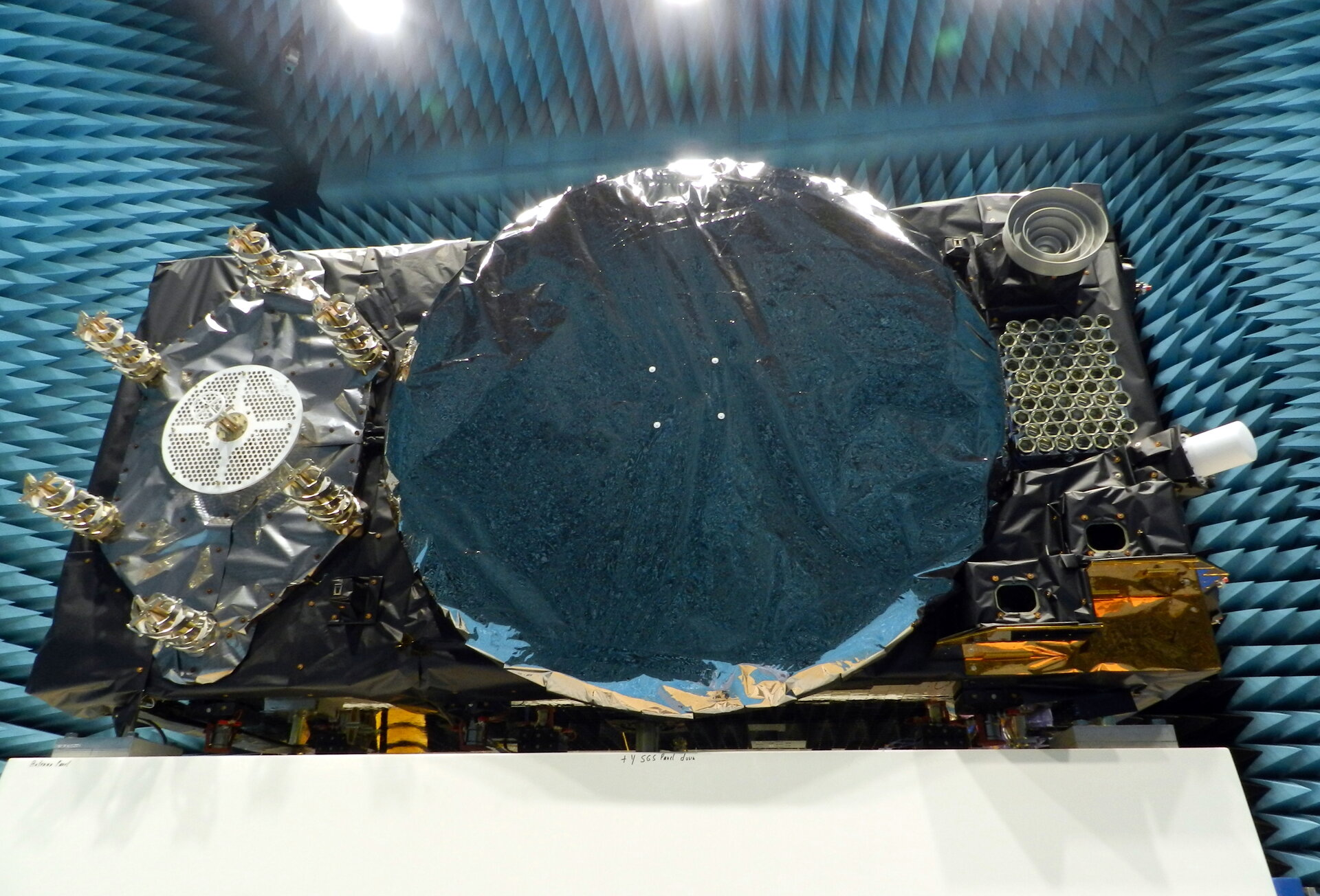
    To the bottom right of the navigation antenna are a pair of infrared Earth sensors to keep the navigation permanently locked onto Earth by homing in on the contrast between the heat of Earth’s atmosphere and the cold of deep space.

    Above them is the laser retro-reflector: lasers are shone up to this from International Laser Ranging Service stations to perform an independent check of the satellite’s orbital position down to an accuracy of less than a centimeter, as a backup of standard radio ranging.

    Above that is the circular C-band antenna, which every 45 minutes or so receives the navigation messages from the Galileo ground segment. These signals incorporate corrections for slight clock errors, orbital drift or satellite malfunctions that user receivers can process as they perform positioning fixes, helping ensure Galileo delivers meter-scale positioning to users around the globe.

    What resembles a white baton on the end of the satellite is its S-band antenna, employed to return “housekeeping” telemetry data to mission control on Earth and pick up telecommands to operate the satellite platform and payload – as well as performing the ranging used to estimate the satellite’s position in space.

    The Maxwell EMC Facility is part of the ESTEC Test Centre in ESA’s technical heart in Noordwijk, the Netherlands – Europe’s largest satellite testing facility, which has flight-tested all but two of the 28 Galileo satellites already in orbit, and is doing the same for the next 10 satellites planned to join the constellation.

  • BAE Systems broadens compatibility of anti-jam GPS receiver

    BAE Systems broadens compatibility of anti-jam GPS receiver

    Image: BAE Systems
    Image: BAE Systems

    BAE Systems has expanded the capabilities of its Digital GPS Anti-Jam Receiver (DIGAR) by enabling beamforming with Trimble receivers, in addition to its own receivers.

    DIGAR’s beamforming capabilities increase the level of GPS jamming protection for aircraft by a million-fold, helping pilots execute their missions in contested environments.

    BAE Systems’ engineers in Cedar Rapids, Iowa, developed software to ensure the compatibility of its antenna electronics with industry-standard embedded GPS inertial navigation system (GPS/INS) technology, enabling fast communication with transmitter electronics for superior beamforming.


    BAE Systems is exhibiting at the ION Joint Navigation Conference, which takes place June 6-9 in San Diego.


    DIGAR beamforms with both BAE Systems receivers and Trimble GPS receivers embedded in aircraft GPS/INS, as well as federated GPS systems and stand-alone GPS receivers.

    “The modern battlespace has evolved, and peer state positioning, navigation, and timing threat systems are challenging our ability to conduct combat operations in the place and manner of our choosing,” said Greg Wild, director of Navigation and Sensor Systems at BAE Systems. “By combining DIGAR’s beamforming with trusted inertial navigation system data, we offer the highest level of jamming protection available today.”

    DIGAR is a high-performance military GPS-based system for fixed-wing, rotary-wing and unmanned airborne platforms. It combines field-proven antenna electronics, advanced signal-processing, and beamforming techniques to improve the reliability of positioning, navigation and timing data in the presence of disruptive electromagnetic signals.

    DIGAR is also compatible with the advanced M-code – delivering additional security to the warfighters who rely on it.

    BAE Systems’ anti-jamming GPS technology has defeated powerful and sophisticated adversary threat systems in testing and combat, and is available for airborne, shipborne and ground vehicle applications. The company’s military GPS business is based in Cedar Rapids, Iowa, where it is building a 278,000-square-foot state-of-the-art research and manufacturing facility scheduled to open this year.

  • FAA awards $4.4 million in drone research grants to 7 universities

    FAA awards $4.4 million in drone research grants to 7 universities

    Photo: PhonlamaiPhoto/iStock / Getty Images Plus/Getty Images
    Photo: PhonlamaiPhoto/iStock / Getty Images Plus/Getty Images

    The U.S. Department of Transportation’s Federal Aviation Administration (FAA) has announced $4.4 million in drone research, education and training grants to seven universities.

    Research will focus on three areas:

    • electromagnetic compatibility
    • detect-and-avoid classifications
    • cybersecurity oversight.

    “This funding and our ongoing partnerships with these universities will allow the FAA to safely integrate the airspace that has a growing number of diverse aircraft users,” said FAA Acting Administrator Billy Nolen.

    The research initiatives and grant awardees include:

    Evaluate Unmanned Aircraft Systems (UAS) Electromagnetic Compatibility

    This research will assess the risks, identify drone design vulnerabilities, identify material and procedural mitigations, and propose guidance for safer electromagnetic compatibility with emitted and static fields.

    • University of North Dakota, $325,042
    • University of Kansas, $325,000
    • Drexel University, $325,830

    Investigate Detect-and-Avoid Track Classification and Filtering

    This research will provide proposed metrics, guidance and test methods to assess the effects of false or misleading information on detect-and-avoid capabilities. The findings will support beyond-visual-line-of-sight operations.

    • The Ohio State University, $732,441
    • Embry-Riddle Aeronautical University, $371,000
    • Mississippi State University, $330,000
    • University of North Dakota, $80,000

    Illustrate the Need for UAS Cybersecurity Oversight and Risk Management

    This research will address UAS cybersecurity oversight and risk management as it pertains to the National Airspace System and other FAA systems.

    • University of Kansas, $651,982
    • Oregon State University, $609,226
    • Drexel University, $608,783

    Today’s announcement is the second round of Alliance for System Safety of UAS through Research Excellence (ASSURE) grants, which brings the total of 15 grants valued at $18.3 million for Fiscal Year 2022.

    The ASSURE Center of Excellence is one of six that the FAA has established to help advance technology and educate the next generation of aviation professionals. Research conducted through ASSURE is focused on helping the drone market safely grow and integrate into the nation’s airspace.

    More than 800,000 recreational and commercial drones are in the active drone fleet, and that number is expected to grow.

  • Power of THOR ready to down enemy drones

    Power of THOR ready to down enemy drones

    The Air Force Research Laboratory (AFRL) has developed a counter-swarm high-power weapon to deter enemy drones — THOR.

    THOR stands for Tactical High-power Operational Responder, a counter-swarm electromagnetic weapon for airbase defense. Although AFRL’s THOR is not a hammer-wielding god associated with thunder and lightning, the system provides non-kinetic defeat of multiple targets. It operates from ground power and uses energy to disable drones.

    The THOR drone deterrent designed by the Air Force Research Laboratory. (Photo: AFRL)
    The THOR drone deterrent designed by the Air Force Research Laboratory. (Photo: AFRL)

    “THOR is essentially a high-powered electromagnetic source that we put together to specifically defeat drones,” said Stephen Langdon, chief of the High-Powered Microwave Technologies Branch of AFRL’s Directed Energy Directorate.

    AFRL is located at  Kirtland Air Force Base, New Mexico. A demonstration system has been built and tested on military test ranges near the base, where it has successfully engaged multiple targets. Further testing against a larger set of drone types in swarming configurations is being planned.

    THOR stores in a 20-foot transport container, which can be transported in a C-130 aircraft. The system can be set up within three hours and has a user interface that requires little training.

    The technology, which cost roughly $15 million to develop, uses high-power electromagnetics to counter electronic effect. When a target is identified, the silent weapon discharges with nearly instantaneous impact.

    With much of the necessary basic research previously completed at AFRL, THOR was rapidly developed and tested in 18 months.

    Although there are other drone defensive systems available, including guns, nets and laser systems, THOR will most likely to extend the engagement range to effect and decrease the engagement time over the other deterrent devices.

    Langdon said the THOR team hopes to transfer the technology to a System Program Office soon in order to get it into the hands of U.S. warfighters as soon as possible.

    AFRL exhibited THOR at the 2019 Air Force Association Air, Space and Cyber Conference at the Gaylord National Resort and Convention Center, located just across the Potomac River from Washington, D.C. and Virginia, Sept. 16-18.

  • OGC invites participation in Electromagnetic Spectrum Working Group

    The Open Geospatial Consortium (OGC) is calling for participation in its newly established Electromagnetic Spectrum Domain Working Group (EM Spectrum DWG). This group will review requirements for an international open standard data model and derived encoding(s) for data describing electromagnetic fields in real-world environments. After reviewing requirements, the group may charter an OGC Standards Working Group to develop the standard data model and encodings.

    Wireless signals, remote sensing radiation, and unintended emissions from artificial and natural sources all interact with both the material environment and the electromagnetic environment. Participants in the OGC EM Spectrum DWG represent the interests of multiple communities that would benefit from being able to easily publish, discover, assess, access, aggregate, disaggregate, and analyze spatial and temporal data describing all the properties of EMFs.

    These communities include the remote sensing, electromagnetic compatibility, and wireless communications communities as well as others. Participants anticipate that the proposed standard will be important in the radio-intense Internet of Things.

    These communities all have in common a set of EMF data definitions, structure and syntax that are almost universally accepted and that are based on well-known laws of physics. The communities also share a set of primary and derived SI units for communicating measurements of the various properties of EMF. In each community, rapidly evolving use cases present requirements to integrate data that includes the spatial properties and other properties of EMF sources and sensors along with data describing properties of environmental features and phenomena that impact, are impacted by, or interact with EMF.

    “On behalf of the Group on Earth Observations, I very much welcome the establishment of the proposed OGC Working Group focused on the Radio Frequency Spectrum with the intent of developing a common international standard data model,” said GEO Secretariat Director Barbara Ryan. “The OGC Electromagnetic Spectrum Domain Working Group will provide an important coordination and harmonization function for future studies of frequency interference. Protecting selected frequency bands for Earth observations is essential for public safety, and hence, of key importance to GEO.”

    The OGC EM Spectrum DWG provides an open forum for the discussion and presentation of electromagnetic spectrum data workflows, interoperability requirements, use cases, and non-OGC EMF standards. It is anticipated that current OGC standards and best practices and inclusion of EMF use cases in future OGC pilots, testbeds and other work will help resolve EMF data interoperability issues. See the OGC EM Spectrum DWG wiki. The wiki includes instructions for joining the EM Spectrum DWG’s public listserv. The DWG’s Charter describes the planned work of the DWG in greater detail.

    The initiators of the OGC EM Spectrum DWG encourage interested parties to learn more and become involved in this important standards activity. OGC members benefit in many ways from their participation in OGC’s standards activities. The first session of the newly formed working group will be held at the OGC Technical Committee meeting in Taichung from 10:15-12:00 CST Dec. 7. The public is invited to attend or call in. Click on the EM Spectrum DWG entry in the TC Agenda for details.