Tag: environmental

  • SPH Engineering’s new high-resolution GPR antennas for UAVs extend subsurface mapping

    SPH Engineering’s new high-resolution GPR antennas for UAVs extend subsurface mapping

    SPH Engineering is offering two new ground-penetrating radar systems optimized for UAV integration: MALÅ GeoDrone 600 and Zond Aero 600 NG.

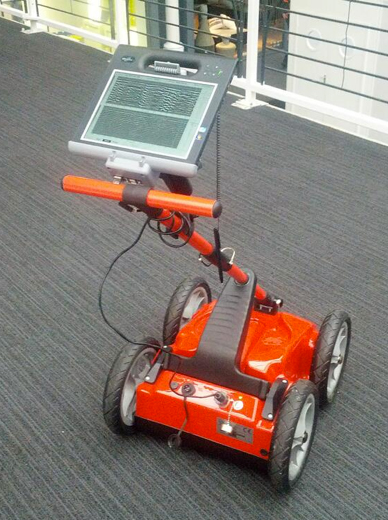
    Both 600 MHz antennas significantly enhance high-resolution subsurface investigations with drones, supporting applications in engineering surveys, utility mapping, archaeology, environmental studies and geophysical research. They enable surveyors to capture consistent, high-quality subsurface data in areas difficult, slow, or unsafe to access with traditional ground instruments.

    Operating at 600 MHz, the antennas offer a balance between penetration depth and fine near-surface resolution. Typical penetration from the drone is up to 2 meters, depending on the surface conditions, while SPH Engineering’s True Terrain Following ensures stable antenna height to maintain data quality and repeatability.

    Compared to ground-based carts or vehicle systems, the UAV-borne configuration enables operators to:

    • Survey rocky, uneven, vegetated, or steep terrain
    • Achieve consistent grid spacing and uniform antenna coupling
    • Cover large areas significantly faster than manual GPR methods
    • Improve safety by reducing personnel exposure in risky field conditions

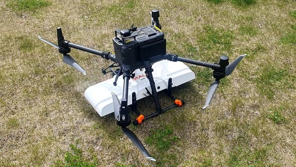
    The MALÅ GeoDrone 600 combines the reliability of MALÅ instrumentation with SPH Engineering’s fully integrated drone workflow. Designed for precision engineering, utility detection, and geophysical mapping, the antenna produces clear, high-quality radargrams suitable for detailed structural assessment and shallow subsurface characterization.

    Key Specifications

    • Central frequency: 600 MHz
    • Operating Bandwidth: 250-900 MHz
    • Typical penetration: up to 2 m (soil-dependent)
    • Sampling: MALÅ HDR technology
    • Antenna design: Shielded
    • Weight: 2.7 kg
    The Zond Aero 600 NG antenna package. (Photo: SPH Engineering)
    The Zond Aero 600 NG antenna package. (Photo: SPH Engineering)

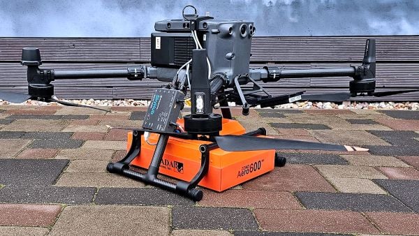
    The Zond Aero 600 NG is a next-generation shielded antenna designed specifically for airborne GPR operations. It offers a strong signal-to-noise ratio, improved ground coupling at low altitudes, and robust performance over natural terrain, making it particularly suitable for geophysical research, archaeology and environmental geoscience.

    Key Specifications

    • Central frequency: 600 MHz
    • Operating Bandwidth: 300-950 MHz (-12 dB)
    • Typical penetration: up to 2 m (soil-dependent)
    • Sampling: Real-Time Sampling (RTS) with high hardware stacking
    • Antenna type: Shielded
    • Weight: 1.7 kg

    Both antennas are fully compatible with SPH Engineering’s UgCS flight planning software and the SkyHub drone onboard computer, enabling:

    • Automated terrain-following flights over complex topography
    • Precise altitude control for optimal GPR signal geometry
    • Synchronized GNSS + radar trace logging (for Zond Aero 600, MALÅ GeoDrone 600 has built-in data recorder).
  • GEO Business expands for 2018, registration now open

    GEO Business expands for 2018, registration now open

    GEO Business, the United Kingdom’s largest geospatial exhibition and conference, has announced that registration is now open.

    The GEO Business show has grown every year since its inception, and the 2018 show looks set to be the most successful show to date with more exhibition space and a brand new seminar program. The event will return to the Business Design Centre, in London, UK, May 22-23.

    Since its record-breaking 2017 event last year, which welcomed 2,386 geomatics and geospatial professionals from around the world (a 48 percent increase since the launch in 2014), the exhibition has expanded onto the upper level. Exhibitors span the entire geospatial industry, showcasing cutting-edge technology and solutions that will mold the future of the industry.

    The 2018 GEO Business show will expand to the second level of the Business Design Center. (Photo: GEO Business)
    The 2018 GEO Business show will expand to the second level of the Business Design Center. (Photo: GEO Business)

    Confirmed exhibitors for 2018 include Survey Solutions Scotland, Land Registry, GAP Group, Phase One, Viametris, Surphaser/ MD3D, DHF Satellite and Ordnance Survey Ireland.

    New for 2018 is a free-to-attend seminar program designed to demonstrate the remarkable impact geospatial technologies and solutions on the global environment. The program will feature case studies from companies demonstrating how they are reducing costs and risk while increasing productivity.

    The 2017 GEO Business exhibit. (Photo: GEO Business)
    The 2017 GEO Business exhibit. (Photo: GEO Business)

    The latest in augmented reality, building information management (BIM), geospatial information systems (GIS) and big data, laser scanning, mobile mapping, remote sensing and satellites, smart cities, surveying, UAVs, virtual reality and visualization will feature within the fields of architecture and construction, commercial property, environmental, equipment theft, floods, forestry, heritage, highways, hydrography, mining, rail and tunneling.

    With geospatial technology now impacting on more and more industries, GEO Business is attracting visitors from a wider range of industry sectors than ever before.

    “The geospatial industry is experiencing a huge transformation, everywhere you look at the moment you bare witness to the term ‘geospatial,’” Show Director Caroline Hobden said. “Innovative technology is steadily making its presence known in everyday life, whether it is through the revolutionary capabilities of augmented/virtual reality or the extraordinary data recorded by drones to name just a few, the world is sitting up and taking notice.

    “Even the U.K. government budget made mention of geospatial at the end of last year and as a result we excitedly await further announcements about the Geospatial Commission whose focus will be on location aware technologies revolutionising the digital economy.”

    The exhibition and seminar program will run alongside a strategic senior-level conference of invited speakers presenting and debating the role of geospatial in powering the Fourth Industrial Revolution, said GEO Business. The Fourth Industrial Revolution is changing how we live, work and communicate. It is reshaping government, education, healthcare and commerce — almost every aspect of life. The conference will celebrate, challenge and develop the role that geospatial has to play in maximizing the digital economy as part of this revolution.

    Visitors will also have the unique opportunity to attend the well-established commercial workshop program hosted by exhibitors demonstrating their latest products and services and a full line-up of innovative social activities designed for informal networking with colleagues old and new.

    The exhibition, workshops and seminars are free to attend. There is a fee-to-attend the conference with an early-bird discounted rate for registrations before April 16. Public sector, association members and student discounts are also available. Visitors are encouraged to register online in advance to beat the queues onsite.

    For more information on stand sales or visitor registration, contact Caroline Hobden at [email protected] or call +44 (0)1453 836363.

  • Eos introduces photogrammetry software for drone photography

    Eos Systems Inc. has introduced new photogrammetry software optimized specifically for photographs taken with drones or unmanned aerial systems (UAS).

    The new PhotoModeler UAS 2016 creates 3D models, measurements, and maps from photographs taken with ordinary cameras built-in or mounted on drones. It has numerous features for operation with drone photos, including post processing kinematics (PPK), volume objects, full geographic coordinate systems support, multispectral image support and control point assist.

    Eos Systems will be showcasing PhotoModeler UAS Oct. 31 to Nov. 2 at the Commercial UAV Expo in Las Vegas, and will offer the new software at 35 percent off the normal price Nov. 1-30.

    eos-photogrammetry-wThe new version of PhotoModeler is suited for drone photogrammetry applications, including surveying, ground contouring, surface model creation, stockpile volume measurement, mining and mine reclamation, environmental analysis, slope analysis, forensic analysis, construction and agricultural crop analysis.

    New applications for drone photogrammetry are developed monthly. Eos PhotoModeler was introduced 23 years ago and has become one of the leading photogrammetric software platforms with a wide range of users in fields such as architecture, engineering, surveying, research, manufacturing and forensics.

    PhotoModeler UAS 2016 software includes numerous features that provide higher performance in drone photogrammetry. Camera calibration is optimized for high accuracy with UASs and GPS. Post processed kinematics (PPK) makes it possible to correct a survey with GPS data after the fact for survey grade accuracy.

    Volume objects provide easy and accurate volume data for stock piles and mining operations. Full geographic coordinate system support enables users to work in their local geographic coordinate system for better compatibility. Support is provided for multispectral images including Normalized Difference Vegetation Index (NDVI) surface models and orthomosaics for precision agriculture. An intuitive interface is provided for efficiently marking ground control points.

  • OGC standard to make environmental data easier for GIS

    The membership of the Open Geospatial Consortium (OGC) has approved the OGC CF-netCDF 3.0 encoding using GML Coverage Application Schema, an extension to the OGC CF-netCDF 3.0 encoding standard.

    The OGC CF-netCDF 3.0 encoding standard has emerged as a widely used and well supported data model and encoding for domains such as atmospheric science, oceanography, climatology, meteorology and hydrology. It supports multi-dimensional data representing space and time-varying phenomena.

    The new extension to the OGC CF-netCDF standards suite specifies how CF-netCDF datasets are encoded to conform to “OGC Implementation Schema for Coverages.” Coverages are data such as the output of weather and climate forecast models, weather station and ocean buoy observations, balloon soundings, ground-base radar, satellite imagery, digital elevation models and lidar point clouds. This extension specifies how these complex multi-dimensional CF-netCDF data are encoded as OGC coverages for use in GIS or other geospatial systems.

    The documents for the OGC netCDF-GMLCOV Standard are available online.

    The OGC is an international consortium of more than 515 companies, government agencies, research organizations and universities participating in a consensus process to develop publicly available geospatial standards. OGC standards support interoperable solutions that “geo-enable” the Web, wireless and location-based services and mainstream IT. OGC Standards empower technology developers to make geospatial information and services accessible and useful with any application that needs to be geospatially enabled.

  • Arrow 200 GNSS Receiver Supports Atlas H-10 Correction Service

    Arrow 200 GNSS Receiver Supports Atlas H-10 Correction Service

    Eos Positioning's Arrow 200 Bluetooth receiver now supports Hemisphere's Atlas correction service,
    Eos Positioning’s Arrow 200 Bluetooth receiver now supports Hemisphere’s Atlas correction service,

    The Arrow 200 Bluetooth GNSS receiver by Eos Positioning Systems now supports the new Atlas H10 GNSS correction service. Using the H10 service, the Arrow 200 GNSS receiver is able to achieve 8-cm accuracy, in real-time, virtually anywhere in the world, the company said. The H10 corrections are delivered by geostationary satellite or via Internet connection.

    The Hemisphere GNSS Atlas correction service, announced in June, is a real-time correction service that meets or exceeds existing correction services. It has three service levels, with H10 having the highest accuracy.

    “Eos is proud to introduce the first GNSS receiver that supports the H10 service,” said Chief Technology Officer Jean-Yves Lauture. “It will allow our customers in every country in the world to have access to sub-decimeter real-time accuracy on all mobile platforms, including iOS, Android and Windows devices.”

    The H10 correction service and the Arrow 200 support all active constellations including GPS, GLONASS, Galileo, BeiDou and QZSS, giving the user ultra-fast convergence time to real-time decimeter accuracy, Eos Positioning said.

    The Arrow 200 employs long-range (1 km) universal Bluetooth connectivity so the user can interface to any brand of smartphone or tablet, whether it’s iOS, Android or Windows-based. The Arrow 200 has been optimized to run all day on battery power. The battery pack is field-replaceable and rechargeable separately. All Arrow receivers have been designed to meet IP-67 specifications for immersion in water and are completely dust-proof so they will survive in the harshest environments.

    The Arrow 200 GNSS receiver with Atlas H-10 service is targeted at high-accuracy applications like GIS, environmental, agriculture, electric/gas/water utilities, surveying, machine control, and federal, state and local government.