Eos Locate for Collector combines three core technologies: Eos Arrow GNSS receivers, Esri Collector, and the Vivax-Metrotech vLoc Series of locator devices.
With Eos Locate for Collector, one field worker can collect both GNSS locations and locator data (such as depth below cover) for any buried asset including water, sewer, electric, cable, gas, fiber infrastructure and more. They can do so quickly, accurately and without the need for any additional field or office support.
“We are giving our Arrow GNSS customers a solution today that allows them to combine both locator data and high-accuracy locations in web maps,” Eos CTO Jean-Yves Lauture said. “This greatly simplifies their workflow by allowing one person to do underground locates and GIS mapping simultaneously.”
“This is a big step forward for utility organizations who need to gain better visibility of their infrastructure,” said Doug Morgenthaler, Esri program manager. “With today’s technology, utilities can already see where new assets are being put in the ground. The challenge historically has been figuring out where existing assets are.”
Eos Locate for Collector not only streamlines underground-asset mapping, but also improves office production times. It eliminates the need to manually combine datasets from the locator and GPS devices within ArcGIS.
“Seeing all that information from utility locators and GPS receivers packaged directly into a GIS application is exceptional,” Vivax-Metrotech Eastern Regional Sales Manager Kelvin Cherrington said. “This solution will help utilities create maps of their underground assets with a much more modern and efficient methodology.”
Indiana American Water Early Adoption
Earlier this year, Indiana American Water approached Eos to seek a solution that consolidated their utility-locate workflow with their Arrow and Collector field work.
“We had the manpower to put paint down,” said Todd Chapman, Indiana American Water Senior GIS Analyst. “But we would need to hire another person to map the locations with our Arrow Gold GNSS receivers.”
Chapman estimates Eos Locate for Collector will cut their field time in half as well as enable the creation of extremely accurate buried-infrastructure maps in ArcGIS.
“Previously, we were seeing that our old water mains could be off by up to 20 feet,” Chapman said. “With the new Eos Locate for Collector, we’re seeing that it’s accurate to under an inch.”
The initial release of Eos Locate for Collector runs on Apple’s iOS iPhones and iPads and supports the vLoc Series from Vivax Metrotech. Future releases of Eos Locate for Collector will support additional locator models including the vScan series.
With accurate digital twins of their buried infrastructure, utilities across sectors can expect improvements to safety, damage prevention, field efficiency and regulatory compliance.
“Not only does this mean quicker responses to 811 tickets and fewer liabilities during field digs,” Lauture said. “But it also constitutes a major step forward toward the highly efficient future of 3D asset management and viable augmented-reality workflows.”
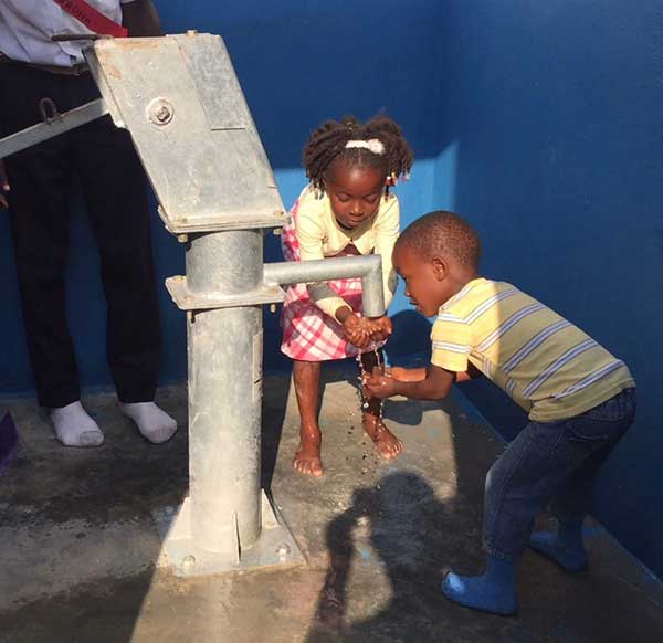
Haiti Outreach is on a mission to bring clean drinking water to 100% of Haitian communes. The non-profit organization is using EOS Positioning Systems’ Arrow Gold GNSS receivers to transform how water access is addressed.
In the Western Hemisphere’s poorest nation, poverty and corruption have stifled development. But Haiti Outreach is using geospatial software and donations to ensure every household has access to clean drinking water. Their technology includes mWater, EPANET, and Arrow Gold with Atlas.
In this video, you’ll hear from Haiti Outreach Director Neil Van Dine and Eos Positioning Systems CTO Jean-Yves Lauture on the importance of combining spatial strategy with a human element.
In Haiti 95% of unprotected springs are contaminated with E. coli, with 48% of water infrastructure across 50 communes delivering water contaminated with E.coli (Haiti Outreach 2018 study). For 22 years, a nonprofit called Haiti Outreach has tried to increase access to clean water by drilling wells for Haitian communities (called communes).
Haiti Outreach tried drilling new wells, but that didn’t solve the problem. The answer is education. “It’s all about creating a transformation in the way we think,” Van Dine said. “Water is free, but somebody has to maintain the well, replace parts, and so on in the long term. All those things cost money.”
Achieving a 50-cents per household fee for maintenance, Haiti Outreach still needed to know if everyone in Haiti had access to clean drinking water. The organization needed to know the location of every household in relation to water sources. They also needed to know if these water sources were clean, contaminated, functioning or broken.
Outreach decided to use the open-source hydraulic-modeling software EPANET, from the U.S. government, and hired mWater to build an integration. By running population-density overlays in mWater, it was possible to identify where there were enough households (25) to create a revenue stream to support a new well. With 100 households, the revenue could support a new in-home water-distribution network.
Photo: Haiti Outreach
They also used Android phones and Arrow Gold with Atlas. By pairing the Arrow Gold with Atlas, they were able to get decimeter accuracy. (Atlas is a satellite-based differential correction service.)
“The Android phones got about 10 meters of accuracy on their own,” Haiti Outreach fieldwork coordinator Micki Johns said. “But the Arrow Gold with Atlas got us within that decimeter range.”
Data collected in mWater went into EPANET to simulate water pressure and flow.
Haiti Outreach used the findings to develop a community action plan (CAP). The CAP prioritized cleaning contaminated sources and ranked contaminated sources by the highest number of people who would benefit from a decontamination.
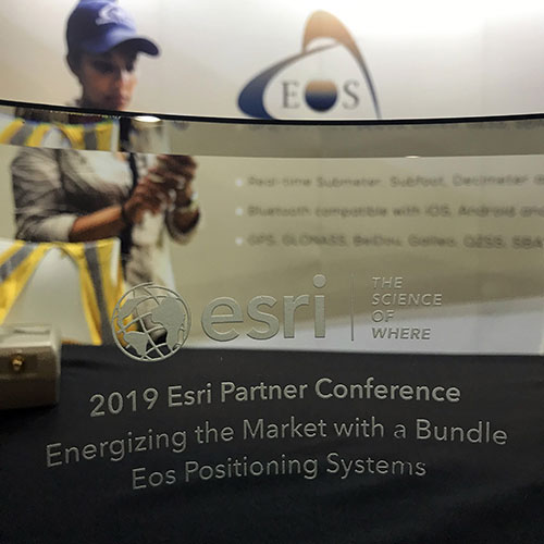
From left: Left to Right: Esri Director of Global Business Development Jeff Peters, Eos Sr. Marketing & Content Strategist Sarah Alban, Eos CTO Jean-Yves Lauture, Esri President Jack Dangermond. (Photo: Eos Positioning)
The award for “Energizing the Market with a Bundle” recognizes Eos’ seamless integration of its Arrow Series GNSS receivers with Esri mobile apps.
Eos Positioning Systems Inc., provider of submeter Bluetooth GPS and GNSS solutions, has received a 2019 Esri Partner Conference award in recognition of Eos’ contributions to Esri mobile applications.
Esri ArcGIS users benefit from bundling the Eos Arrow GNSS receivers and Esri mobile apps to create real-time, high-accuracy field GIS solutions on consumer devices such as iPads, tablets, and smartphones.
Photo: Eos Positioning
“As a long time Esri partner, this ‘Energizing the Market Award’ highlights the ongoing value Eos brings to our shared customers,” said Francis Kelly, Esri manager of Global Partner Programs. “Their thoughtful approach to connecting the field worker to the enterprise GIS creates customer satisfaction and significant ROI across our business sectors.”
“Eos has done tremendous work bringing affordable high-accuracy receivers to the Esri user community, whilst taking advantage of the latest Esri technology including Collector for ArcGIS and Survey123 for ArcGIS,” Esri Canada Director of Strategic Alliances Paul Salah said. “I couldn’t be more pleased to have them recognized for their innovation that brings such great value to field workers everywhere.”
Eos’ mission is to turn the complex world of high-accuracy submeter and RTK location into simple and affordable integrations to the Esri ArcGIS platform. This is achieved with behind-the-scenes transfers of high-level GNSS information with Esri mobile apps.
The exchange is nearly transparent to the end-user, and therefore minimizes the knowledge required for anyone to capture survey-grade 3D locations.
“It used to be really hard to collect high-accuracy data,” said Christa Campbell, Esri Global Water Practice Industry Specialist. “But now it’s very easy and affordable, so there are no limits any more. Anyone can do it.”
2018 saw small-system water utilities, municipalities, consultancies, co-ops and others adopt high-accuracy GIS at increasing rates. Eos believes this is due to a changing understanding of how easy and affordable high-accuracy data collection can be with the Eos/Esri bundle.
“We are showing that anyone can map an entire system, regardless of the size or the person’s familiarity with GNSS and GIS,” Eos CTO Jean-Yves Lauture said. “We are showing that it is simple, affordable, and profitable.”
The adoption of high-accuracy solutions among GIS users coincides with a general shift toward digitized asset management, away from paper maps and CAD drawings.
The shift is the natural result of more affordable and easier to use technologies, the proliferation of smart devices, and industry trends including increased regulations.
“Now more than ever, customers want to start taking advantage of the tremendous flexibility GIS has to offer,” Lauture said. “And the first step in creating an accurate system of record is field mapping with GPS.”
In 2018, Eos released two new innovative solutions for ArcGIS users.
The first was the result of a three-way partnership between Eos, Esri and Laser Technology, Inc.
Known as the “World’s First Laser Offset for Collector for ArcGIS,” this laser mapping solution allows field workers to collect highly accurate (submeter or centimeter) locations on their iPads and iPhones in otherwise challenging environments.
This includes GNSS-impaired environments, where view of the sky is obscured or limited, and places where occupying an asset would be unsafe or expensive (such as a manhole located in a road intersection).
“With the new collector-based laser mapping solution, organizations can save money, minimize risk and boost the efficiency of their field operations,” Esri Field Apps Product Lead Jeff Shaner said. “Without having to occupy assets in challenging environments, field workers can capture asset locations within inches of accuracy using the Eos Arrow and LTI rangefinder. This unique partnership provides advanced field data collection capabilities and drives new opportunities to extend the reach of ArcGIS.”
The second solution feeds real-time orthometric heights (Z values) directly into Collector and Survey123 for ArcGIS. By supporting real-time GEOID models, Eos eliminates the need to transform ellipsoidal heights into local vertical datum manually back at the office. This reduces time-consuming post-processing as well as makes accurate elevations instantly available for use in the field.
Eos is dedicated toward providing its customers with innovative solutions like this, which allow Esri users to stay within their existing ArcGIS mobile environments.
“This award acknowledges the work Eos has accomplished so far in bringing innovative solutions to our mutual customers with Esri,” Lauture said. “It is quite an honor for everyone at Eos, and we are especially thankful to all the Esri employees who have made the journey in getting here so enjoyable. It’s what makes us look forward to doing more in the future.”
Eos Positioning Systems has donated an Arrow Gold GNSS receiver to Haiti Outreach, a 21-year-old nonprofit organization dedicated to helping Haiti become a developed country.
Haiti Outreach collaborates with individual Haitian communities to create and maintain access to potable water through community outreach, well digging and distribution-network development.
The Arrow Gold GNSS receiver helps Haiti Outreach build and improve potable water distribution networks by providing accurate subfoot elevations required for hydraulic modeling simulations, the company said. It uses Atlas satellite-based corrections to provide real-time decimeter (three to five centimeters) location throughout the country.
“Water is life, and making this basic necessity available to every person is at the foundation of Haiti Outreach’s work,” said Eos Positioning Systems CTO Jean-Yves Lauture. “I believe strongly in Haiti Outreach’s long-term vision to empower Haitian communities through development, education and cooperation.”
Haiti Outreach first began in 1997, with a mission to bring clean water to more people in Haiti and encourage them to take on the responsibility of maintenance and sustainability. In 2005, the organization shifted its focus toward greater community outreach and support, developing a program much more effective at producing the desired long-term outcome. Its community-led initiatives are heavily planned and prioritized, thanks to comprehensive field data collection and advanced geospatial analysis, Eos said.
“In most of these communities, there has only ever been a short-term vision, because the need has always been urgent,” Lauture said. “Haiti Outreach is changing that mentality. They are providing a development plan for now and the future. This is a slow process but is already proving successful. It is a true privilege to be able to support such noble efforts.”
From left: Esri Program Manager Doug Morgenthaler, Laser Technology Sr. Product Manger Derrick Reish and Eos CTO Jean-Yves Lauture. (Photo: Eos Positioning)
The three-way partnership will enable field crews to collect centimeter-accurate 3D data in GNSS-impaired environments.
When combined with Laser Technology Inc.’s (LTI’s) laser rangefinders, the solution will allow field crews to capture centimeter-accurate 3D locations of hard-to-reach assets and in GNSS-impaired environments.
“By combining the high-accuracy of the Eos Arrow Series GNSS receivers and the laser capabilities of LTI, we can empower field crews to capture highly accurate XYZ coordinates from a safe distance,” LTI Senior Product Manager Derrick Reish said. “This eliminates the need for physically occupying every point. It also provides more accurate location data, with a more affordable mobile asset-management workflows.”
The Arrow Gold. (Photo: Eos Positioning)
The solution has been in the works for months, as demand has grown for hard-to-reach, high-accuracy mapping within the Collector workflow.
“Eos is extremely grateful to be a part of this initial release in high-accuracy asset location data with LTI’s laser rangefinders and Esri’s Collector mobile app,” Eos CTO Jean-Yves Lauture said. “Enabling this kind of accuracy means even the most budget-conscious field crews will be able to access the location of their hard-to-reach assets.”
All three teams have been working closely to ensure a seamless integration with Collector and ArcGIS Online. When using an LTI laser rangefinder and an Eos Arrow Series receiver with Collector, a field worker can easily shoot, capture and share high-accuracy 3D location data that is streamed into ArcGIS Online in real-time.
Image: Eos Positioning
The solution is expected to be particularly useful in urban corridors, highway settings, forested (or wetlands) areas, and other areas where assets are hard or dangerous to occupy. This will both increase accuracy and efficiency, as well as decrease safety liabilities in dangerous situations, the companies said.
“Esri is extremely pleased that Collector can now support the capture of high-accuracy asset locations from afar, leveraging our unique partnership with both Eos and LTI,” Esri Product Manager Jeff Shaner said. “This is a game changer for asset management.”
Prior to this release, field crews challenged with capturing high-accuracy 3D locations for hard-to-reach assets would need to use a total station with a different software workflow and then mesh the data back in the office, a clumsy and inefficient workflow requiring lots of additional training and expertise. With the new workflow, field crews can operate in GNSS-impaired environments at a high-accuracy level without leaving the Collector/AGOL environment, creating a highly efficient workflow.
The solution has been designed to provide several offset-mapping methods.
“The implementation of several measurement methods gives users the freedom of choice, so they can pick the right laser option which meets their accuracy needs,” Reish said.
Eos will unveil its offset measurement solution for Collector at the upcoming Esri User Conference in San Diego. For a field demonstration of how the solution works, attendees can visit Eos at booth #1019 during the conference, and attend the session “LaserGIS for Everyone: How to Combat Costly and Tedious Data Collection Workflows” at 10 a.m. on Wednesday.
Eos Positioning Systems Inc. is partnering with enterprise mobile solutions provider CartoPac International to enable consumer smartphones and tablets to become professional-grade GNSS data collection and management devices for staking, inspections and more.
Eos manufactures the Arrow receivers for any smartphone or tablet. CartoPac develops enterprise utility software, including a mobile solution for asset management and data collection.
As utility and energy companies have begun to adapt smartphones as their primary data-collection devices, they have struggled to find integrated solutions that can tie the high-accuracy GNSS locations to their new and legacy assets. Their options were usually limited to onerous workflows of all-in-one handheld GPS devices or the hiring of specialized surveyors.
Eos and CartoPac partnered to integrate the Arrow Series with CartoPac‘s mobile software. This allows CartoPac users to bring submeter and centimeter location into their asset-management solution on either iOS, Windows or Windows Mobile devices.
One real-world example is the installation of an underground pipeline. A field user with CartoPac software and a high-accuracy Arrow receiver paired with an iPad was able to capture submeter asset data, scan the asset’s barcode, take photographs and populate the utility’s enterprise geodatabase in real time, the companies said.
With the right mobile solution, field crews can also be dispatched in no time to the same asset location to respond to emergencies or perform routine work orders and inspections.
“We saw our users struggling to get a good high-accuracy GPS solution within the iOS environment,” said Glenn Vlass, CartoPac co-founder and senior sales executive. “When you can say where an asset is spatially with such a degree of high confidence, that lowers your risk and improves your safety. Lower risk and improved safety are things every utility worker takes seriously.”
Eos and CartoPac plan to expand their deployment of high-accuracy mobile asset management to more utilities facing similar needs.
Over the past two years, I’ve been sharing my view on land surveying over a variety of topics. One of the constant themes I try to maintain is technological improvements and how surveyors need to continue to embrace new applications and equipment.
While I will also argue that we cannot forget our surveying roots (see GPS World, March 2017), we still need to keep an eye on future technologies, means and methods to increase our productivity and profitability as well.
With this idea of peeking at the road ahead, I traveled to Berlin, Germany, to cover Intergeo 2017, an international trade show for everything geospatial.
Held every year at different venues around Germany, Intergeo is the world’s largest conference and exhibition for geodesy, geoinformation and land management. The theme of the conference this year was “We are bringing worlds together,” and based upon the number of vendors, new equipment and applications, and record breaking attendance, it was quite evident they hit their mark.
The numbers were astounding: 580 vendors from 37 countries, 18,000+ visitors from 100+ countries, all packed in six interlinking halls covering more than 325,000 square feet (7.5+ acres). When I spoke with several contemporaries who previously attended Intergeo, all warned me to be ready for the size and scale of the facility, the number of vendors, and the large spaces occupied by the big survey players. Truly thinking this rhetoric was hyperbole, I went with guarded expectations. Boy, was I in for big surprise.
Walking up to the entrance, one could sense immediately the size and enormous presence of this conference. The registration lines were easy and efficient, with plenty of entry gates and attendants to help with any information. When I entered the first hall for my initial visit, the prior warnings about the size and scale were quite true. This conference was three days long, and I knew I was going to need every minute to cover all the bases.
My account here is broken into four sections — one hall per day. Leica, NovAtel, Laser Technology and Septentrio were among the first booths I encountered on day one. Javad, ComNav, Hemisphere and Emlid were in the next hall over, and can be found below “Behind Door Number Two.” Day three found me hobnobbing with CHC Navigation, EOS and Swift Navigation; look for them under “I’ll Take Hall Three for $200, Alex.” I topped off my Intergeo experience interviewing NavCom, Tersus and Trimble in “The Big Finish (Or Is It?)”
ENTERING ANOTHER DIMENSION…
Coming into Hall 1.1, the first thing that catches one’s eye besides the vastness of the entire space is the size and depth of the Hexagon exhibit. Hexagon is the parent company of Leica, NovAtel, and several others, and all were there displaying new products and software for a multitude of geospatial needs.
I was introduced to the new Leica GS18T GNSS RTK rover (Leica Geosystems debuts GNSS RTK rover at Intergeo 2017) with many new upgrades, including being able to measure a point while the unit is not being held plumb. Yes, you read that right; the unit has an inertial measurement unit (IMU) built in that compensates for any rod tilt and corrects the location back to the bottom of the rod. Now it is possible to collect a GNSS location to places and objects no longer thought possible.
This feature has been available with the “J-Tip” from Javad for the past year: now Leica has added the capability to the GS18T.
While the demonstration took care of my skepticism of the unit, it raised different concerns with the field personnel using it. This method of “no bubble” is fine for this unit, but I can envision crews getting sloppy with conventional GNSS and total station prism rods when mixed with this new technology. This will increase the need for proper training and trust that the all rod-based equipment is used in its intended manner and procedure.
NovAtel was on hand with presentation of a full line of GPS receivers, boards and peripherals, including its GAJT line of anti-jamming receivers as well as an “interference” toolkit of analyzing software modules. With the solid product line and software, the company motto of “assured positioning” bodes well for its users.
Laser Technology Inc. has provided many measurement breakthroughs over the past few decades, and its introduction of the TruPoint 200h is no exception (see Laser Technology highlights TruPoint 200h at Intergeo 2017). The company has taken the TruPoint 200 line of measuring devices and expanded its capability with phase shift and pulse diode measurements, which means the unit will determine the most accurate method based upon reflectivity. This is also paired with a data collection and reporting application on your Android smartphone to greatly expand your ability to share your data.
Also at Intergeo introducing a new GNSS receiver was Septentrio, a navigation systems developer from Belgium. Septentrio was showing the Altus NR3, a lightweight multi-constellation receiver aimed at the surveying and mapping community. This new unit boasts an AIM+ system designed to monitor and protect the user’s data from jamming and spoofing so the collected data is confidently accurate.
Carlson displayed its new BRx6 multi-GNSS receiver along with the RT3 tablet data collector. The BRx6 receiver expands the Carlson family of GNSS products to include connection to most RTN systems worldwide as well as the Atlas L-band correction service that is beginning to gain many followers. Paired with the new RT3 tablet, these products continue the look, feel and service that Carlson users have enjoyed for many years.
Sokkia was there with a full complement of surveying and monitoring equipment, with the GCX3 GNSS receiver being the main focus of their new products. This unit sets the bar even higher for light and efficient GNSS receivers as it weighs only 440 grams with the batteries, yet is more capable than many similar systems on the market.
Another new GNSS receiver introduction was from Hi-Target, the iRTK-5. This new model is the one of the first units to have an OLED touchscreen on the receiver. It supports reception from all major GNSS constellations as well as the L-band correction service. Hi-Target prides itself on a new proprietary differential correction technology that analyzes the integrity of data from all sources before providing a position. This model also has a 4G LTE chipset that will communicate with almost all cellular systems worldwide.
One thing that stood out to me that differs greatly from surveying in the U.S. is the proliferation of monuments and monitoring points/devices used by surveyors throughout the world. So, the multitude of vendors offering varying kinds of targets, prisms, and survey point markets should not have shocked me, but it still did. It was quite impressive with the walls of targets and prism assemblies for many different applications along with the tables of nails, tablets, monuments and vault systems used by surveyors worldwide. Among the notables were Rothburcher Systeme and Bohnenstingl, who both offer a complete line of products beyond most surveyor’s imaginations.
The Juniper Systems booth showcased the Mesa2 rugged tablet and the Geode sub-meter GNSS receiver, both designed with efficient mapping collection in mind at an affordable price point, yet rugged enough to take on most environments. They were also highlighting their CT5 rugged smartphone and CT7G rugged tablet as solid products for any surveying and mapping data collection need.
BEHIND DOOR NUMBER TWO
After navigating the first of four conference areas, I wondered if all the remaining halls would be just as impressive. Hall 2 did not disappoint, as the exhibit spaces were just as big and remarkable as the first one.
Already a major entity within the GNSS community, Javad came to Intergeo 2017 to introduce its entry into the UAV market, the Triumph F-1. Unlike other UAVs, this unit was designed starting with the GNSS engines Javad is known for; engineers then built the flying craft around the brains of the system. It utilizes the same DNA of the Triumph-LS receiver along with ease of Javad software, all on a multi-rotor platform with hot-swappable batteries.
Aimed for more agricultural users, ComNav introduced a lightweight GNSS receiver, the T30, and a new software guidance system compatible with most tractor configurations. This system is designed to be more efficient and precise than OEM tractor guidance as well as more customizable for the user.
The company behind the new Atlas L-band correction service, Hemisphere GNSS, also provided introductions to several new products at Intergeo. In addition to several navigation chipsets for OEM use, they also introduced the 321+ GNSS Smart Antenna. This new receiver is multi-frequency and multi-GNSS with an Athena RTK engine and Atlas L-band global corrections to cover most positional needs. With hot-swappable batteries, this unit will run over 12 hours on two sets that are provided.
EMLID may be a newcomer to the GNSS environment but they are making noise by offering new products and technology at price points for more consumers. At Intergeo, they were demonstrating the Reach RS GNSS receiver with RTK capability, the Reach GNSS module for UAV systems and the Edge module, an advanced drone controller with HDMI video input and 5.8 GHz data link. These guys are my sleeper pick for becoming a bigger player in the very near future.
Topcon’s space, which included industry partner Intel included an interactive dome using their “Immersive Point Cloud Workspace” software and 3D point cloud data to give attendees a virtual reality tour of sites previously mapped with Topcon equipment and software. This four-meter dome was a popular stop with visitors, as was the product introductions of their SmoothRide software and the MAGNET Collage desktop mass data processing software. In addition, another product showcased in conjunction with Intel was their UAV systems, led by the Sirius Pro fixed wing vehicle and the Falcon 8 multi-rotor vehicle.
The main presentation from Bentley to the surveying/GNSS community was the increased capability of their ContextCapture software module. With 3D point clouds and virtual reality systems become the norm, Bentley has upped their game with visualization tools and features within this module not found in many point cloud software packages. The biggest improvement is the ability for survey-grade data acquired through laser scanning, LiDAR and photogrammetry to be easily input and manipulated for many different uses. From BIM to roadway corridor modeling and asset management, these improvements are making the utilization of 3D data more seamless.
Something that caught my eye initially as a novelty was TinyMobileRobots, a Danish company producing a small unmanned cart for marking surfaces. They currently have three products: the TinySurveyor, the TinyLineMarker, and the TinyPreMarker. All have GNSS receivers that operate autonomously on a predetermined route and carry a paint can for marking specific points. From marking athletic fields to paint striping, they might be on to something quite unique but very cool.
I’LL TAKE HALL THREE FOR $200, ALEX
Hall 3 brought us to CHC Navigation and their full range of surveying and mapping products. Highlighted during our discussions with them was the M6, i70 and i80 GNSS receivers and the Apache 5 USV boat for hydrographic applications. It was quite evident how large of a company CHC is and how vast their global presence is so don’t be surprised to see them in North America soon.
EOS Positioning Systems is another smaller GNSS receiver producer that is targeting the mapping community with the lower entry pricing and smartphone application interfacing. From the basic L1 receiver for mapping to the multi-constellation, triple-frequency model including Atlas L-band corrections, EOS is providing an easy to use package at an affordable price point.
Another entry in the OEM board/system provider of centimeter-level accuracy systems is Swift Navigation and their Piksi line of products. From agricultural applications to autonomous vehicle positioning, they are providing navigational systems that will guide our future. As the surveying community expands its use of unmanned vehicles, I would not be surprised to see Swift at the forefront of this effort.
Another member of the Hexagon family, the Geomax display was loaded with everything imaginable for measuring and remote sensing. The main introduction for Intergeo 2017 was X-PAD Office Fusion, an all-in-one software package that allows the data from various sources to come together in one place for creating and manipulating 3D models. While I was not familiar with Geomax, it was quite evident that their customer base, while European-centric, was big and quite loyal to the brand.
A newcomer to the surveying world is Pix4D and their photo processing software. Used by many UAV enthusiasts and now surveyors, Pix4D has quickly become one of the largest providers of software for creating orthometric photos that are georeferenced to known coordinate systems and GIS databases. Most of their success has been because of ease of use and affordability versus the leading surveying software packages. They are also industry partners with Esri and DJI, so having big friends in popular places has helped their cause. Look for more great stuff from them for surveying applications in the near future.
THE BIG FINISH
As I entered Hall 4, I began to wonder if I was done with the major attractions and getting into the bit players. I was wrong.
The first stop was Geozone, who was introducing a new receiver, Falcon SF, through a collaboration with NavCom. This new unit features multi-constellation and multi-frequency collection, but also includes Starfire, a global system designed and maintained by NavCom that is a satellite-based correction signal and provides accuracy of 5 CM anywhere in the world. This correction system comes standard with a subscription when you purchase the receiver, which is unheard of in most surveying environments. This is another product I predict that will be making more of a global presence in short time.
Tersus GNSS was at Intergeo to introduce many OEM navigation boards and an RTK system for surveyors and autonomous control systems. The Tersus David RTK system is designed to turn your smartphone into a high accuracy GNSS data collector. This system is highly durable and compact so it will accommodate many different mapping needs.
Another company that has global reach but not much exposure to U.S. business, South Surveying & Mapping Instruments, wouldn’t give an attendee the impression that they are a small player in the surveying world. Their exhibit space was impressive, ranging from simple theodolites to high accuracy robotic total stations, RTK GNSS receivers and fixed-wing/multi-rotor UAVs.
As lidar technology becomes more available and affordable, a stop at the Riegl booth was a must. They were introducing many new products at the Intergeo 2017 show, including the miniVUX-1DL UAV laser scanner for multi-rotor and fixed-wing aircraft. This little beauty weighs under 3 kg and fits on most scalable UAV platforms.
Another fun item on display was the VMX-2HA Dual Scanner Mobile Laser Scanner, which looks like a high-tech octopus on top of your vehicle. This unit collects 2 million measurements per second as well as 9 x 12MP camera images at various angles. As the miniaturization of technology continues, I see RIEGL continuing to lead the lidar segment well into the future.
Just when I thought I was almost done, I realized that there was one major player left that I had not seen: Trimble. They were in the back of Hall 4 across almost the entire width of the conference space. Everything geomatics, remote sensing, and navigation; it was here in one of the biggest exhibition spaces at Intergeo 2017.
All the latest surveying instruments were here, including the R10 GNSS receiver and SX10 scanning total station. The new items for surveying at this show were numerous; the C3 and C5 mechanical total stations with autofocus, Catalyst software with GNSS receiver for smartphones, the T10 rugged tablet for survey and GIS applications, and OEM receiver boards (BD940-INS, BD992-INS and BD990).
Also included within the Trimble space were Nikon and Spectra Precision branded instruments as well as the latest acquisition, Applanix GNSS-aided inertial movement systems. While Trimble has grown considerably in the past decade, it seems as nothing will slow them down. If they continue to introduce great products and technology, I wouldn’t bet against them.
BUT WAIT, THERE’S MORE…
There were three more halls, with two of them being organizations and information booths. Hall 6, however, has grown into a standalone space as “Interaerial Solutions,” Europe’s biggest UAV show. All the main players were in here (including DJI, DroneDeploy and over 150 more) so almost everything imaginable with UAVs can be found here.
During the conference, the adjacent courtyard was utilized for UAV demonstrations and product introductions. It will be interesting to see in the coming years if this segment of measurement and remote sensing will continue to expand with number of vendors/suppliers or if it will get absorbed by many of the bigger players within the geomatics community.
INTERGEO 2017, IN RETROSPECT
The common theme/message through this gathering was digitalization, “smart cities” and the evolution of the occupations that work within these environments. Intergeo is an impressive gathering of likeminded people discussing how to manage the increasing waves of data through technology, analyzation and thought processing.
While I can’t say that these types of gathering do not happen in the U.S., it is not as obvious as the annual assembly of Intergeo in Germany. The surveying community in the United States needs to hold a similar “summit” to help guide the profession toward its future goals. The one thing I have always appreciated about surveying is how it does embrace technology and forward thinking yet must rely on the past to tell us where we have been.
Digitalization is here and cities will get smarter with or without us, so it’s up to us as surveyors to keep looking forward with the times. Global measurement and navigation will be a big part of that, so let’s put our thinking caps on to see what we learn next.
Until next time, guten tag und gute gesundheit.
A big thank you also goes out to my fellow Intergeo members Ryan Gerard, Mike Joyce, and Allison Barwacz for making this a wonderful experience.
Last year at InterGeo 2015, UAVs ruled, for at least the second year in a row, although some of its newest-thing gloss seemed to be wearing off. This year, sensor integration in both hardware and software is a dominant theme — and one with broader implications and applications.
GNSS positioning technology, aided in many cases by laser scanning, other imaging sensors, total stations, Lidar and camera systems, all collaborating as inputs to mobile mapping systems or machine-control systems, together form a durable platform for many present and future applications.
NavCom booth at InterGeo.
Among the GPS/GNSS companies exhibiting here: CHC Navigation, ComNav Technology, Eos Positioning Systems, Hemisphere GNSS, Navcom Technology, NovAtel, Septentrio, and Tallysman.
“I think it’s a must for every surveyor to participate and get updated with all the developments,” said Chryssy Potsiou, president of the International Federation of Surveyors (FIG), “to try to make the best combination of tools and software so that we can have the best output, in order to provide reliable services at affordable prices, in short time. The world needs solutions, cheap and fast.”
Smart Cities. Along with the roar of the four connected exhibition halls where many new products are being rolled out on this premier world stage, there is a lot of talk — a lot of talk — in the presentation auditoriums about vision, and smart cities, and connectedness in it many forms, electronic and otherwise.
The international trade fair for geodesy, geoinformation and land management, InterGeo can be overwhelming, with roughly 550 exhibits from 33 countries, and 16,000 visitors from 92 countries. It spans everything from surveying, geoinformation, remote sensing and photogrammetry to complementary solutions and technologies, processing, using and analyzing geodata over the Internet and exploring new applications and solutions — it’s all here. Themes include mobility, energy supply, climate protection, and liveable cities and rural areas. Citizen involvement, data protection, data security and e-government all play a key role in future developments. This year, the conference published a pre-show report on geodata and what it calls Business World 4.0.
Host city Hamburg, an economically strong, vibrant city and one of the top three shipping ports in Europe, embraced digital strategy at an early stage. Sustainable city planning, climate protection, an intelligent mobility concept and IT-controlled port management are all aspects of the city that could not work without geodata.
Making Connections. “Our [geospatial] industry is now more and more related, more and more embedded with many other disciplines,” said Nigel Clifford, CEO of Ordnance Survey UK, who gave one of the conference keynotes. “One of the key questions we are facing is: What skills will the workforce of the future need to have, in order to flourish in this interconnected world?
“Some of the more obvious ones are digital capability, looking at data sciences. Also we spoke about some of the softer skills: the ability to look across disciplines, the ability to work with different functions, and really importantly, the ability for our industry to explain its value and be part of the decision-making which is going on around us all the time.
“We’re beginning to see the first fruits of the Internet of Things. There may be some inflated expectations at this point. It’s our job to test that. I’m confident there are some brilliant use cases developing over the next five years in the fields of health, transport, and community engagement. Making a city more efficient, more livable, more secure, and more business-friendly, to draw tax dollars into the equation. What we’re able to do today is so much more data-rich, so much more connected, than we’ve ever been able to do before. ”
He cited pilot public-private partnership projects in Manchester and another unnamed UK city going forward in this regard, with involvement from Cisco, Siemens, and British Telecomm along with Ordnance Survey. “It’s a mixed economy coming together, because there isn’t one answer.”
Looking into the future, he said “Developing nations in particular require a fundamental geospatial fabric in order to boost themselves. I hope there will be a broadening of the focus from what we can do absolutely at the cutting edge of technology with reasonably affluent societies, to thinking about how we can take that into the less affluent societies, and raise all boats through the efforts of this great industry.”
Gorillas Enter Room. Intel has taken a stake in the commercial drone space with its new Falcon UAV. “Predominantly, we are looking at inspections, construction, agriculture, as well as 3D modeling.” The company was joined by Oracle and Autodesk as first-time exhibitors at the show, and they did not enter timidly; big stands.
UAV über Deutschland. In moves shadowing those in the United States, the German Minister for Transport spoke about introducing regulations to govern civil and commercial use of UAVs. The newly published draft foresees the introduction of mandatory registration for unmanned aerial systems. Pilots will need a valid license to fly drones above 100 meters.
Eos Positioning Systems has announced its most advanced high-accuracy Bluetooth GNSS receiver, the Arrow Gold. The Arrow Gold is the first high-accuracy iOS, Android and Windows Bluetooth GNSS receiver to implement all four constellations (GPS, GLONASS, Galileo, BeiDou), three frequencies (L1, L2, L5) and satellite-assisted RTK.
The Arrow Gold provides 1-cm real-time accuracy in more places, and on all iOS, Android, and Windows devices. The palm-sized Arrow Gold works with any data-collection app designed for iOS, Android or Windows, which means that apps like Esri Collector, Esri ArcPad, Survey123 and others work with Arrow Gold right out of the box.
The Arrow Gold introduces an innovative RTK feature for poor cellphone coverage areas — SafeRTK. The SafeRTK feature uses satellite corrections to fill in when the user’s RTK network connection is lost. Even in populated urban areas, wireless connectivity has dead spots. For traditional RTK receivers, this is a deal-breaker. For the Arrow Gold, SafeRTK takes over when wireless coverage fails, allowing users to continue working with centimeter accuracy for up to 20 minutes, free of charge.
Another pioneering feature of the Arrow Gold is 8-cm real-time accuracy anywhere in the world, at a revolutionary price point. On all iOS, Android and Windows devices, the Arrow Gold Basic delivers 8-cm real-time accuracy anywhere in the world using all four satellite constellations and the Atlas satellite correction service.
The Arrow Gold is built for tough environments. It is palm-sized, waterproof, dust-proof and weighs under one pound. It works in the rain, dust, dirt and in rugged environments. The user can mount the Arrow Gold on a range pole or slide it in a vest pocket. The Arrow Gold’s long-range, rock-solid Bluetooth radio stays connected to your mobile device up to 1,000 meters away, and it’s field-replaceable rechargeable battery pack lasts all day.
Owing to its support of all global satellite constellations (GPS, GLONASS, Galileo, BeiDou) and all planned satellite signals, the Arrow Gold will provide cutting-edge, high accuracy for the next decade, providing a return on investment (ROI) that will serve its users for years to come, Eos Positioning said. It doesn’t matter if user decides to switch from iOS to Android to Windows during the same project or years from now, the Arrow Gold has universal Bluetooth compatibility that supports all mobile devices for the forseeable future.
The Arrow Gold is targeted at high-accuracy applications such as GIS, environmental, agriculture, electric/gas/water/telecom utilities, surveying, machine control, and federal/state/local government.
Eos Positioning Systems has announced that its Arrow series of GNSS receivers is compatible with Esri’s Collector for ArcGIS running on iPads and iPhones. The Arrow receivers have been tested and certified as high-accuracy GNSS receivers compatible with Collector 10.4.0 for iOS.
The full range of Arrow GNSS receivers from sub-meter to decimeter to centimeter RTK accuracy all work flawlessly with Collector for ArcGIS running on all iPhones and iPads running iOS 8.x or later, according to the company. GNSS metadata — including estimated accuracy, correction status, correction age and number of satellites used — is displayed in real-time in Collector, so the user can monitor data quality in the field.
“We worked closely with Esri during their development of Collector to ensure the best high-accuracy GNSS user experience with the Arrow GNSS series receivers, and I think we’ve achieved that,” said Eos CTO Jean-Yves Lauture. “Whether it’s our Arrow Lite, Arrow 100 or Arrow 200 receiver, they all work smoothly with Collector for iOS for sub-meter, sub-foot, decimeter and centimeter accuracy.”
Eos Tools Pro.
As a companion software to Collector, Eos offers a free iOS app called Eos Tools Pro that allows the user to connect to an RTK network and to set alarms for estimated accuracy, HDOP, correction age and others. If a threshold is exceeded (such as estimated accuracy greater than 10 centimeters), an alarm sounds on the iPhone or iPad to alert the user.
“We have tested Arrow receivers and confirmed that Collector for ArcGIS (iOS) is completely compatible with the Arrow GNSS series receivers,” said Esri Product Manager Jeff Shaner. “The tight integration between Collector and Arrow GNSS receivers really enhances the high-accuracy user experience, and during our recent beta program, customers like Le-Ax Water District have shared their success using Collector and the Arrow receivers.”
Collector for ArcGIS (iOS) is a geographic information systems (GIS) data collection program that runs on iPhone and iPads. It records data directly, in real time to ArcGIS Online, Portal for ArcGIS and ArcGIS Server at sub-meter, decimeter and centimeter accuracies when using the Arrow GNSS receivers. No post-processing or other specialty software is required.
Collector 10.4.0 can be configured to automatically transform between horizontal datums on-the-fly, so no matter which datum the user’s GNSS data is referenced to, it can be configured to be compatible with the user’s geodatabase, and Esri provides scripts for transforming between vertical datums when back in the office.
Eos GNSS Tools and Arrow receivers are targeted at high-accuracy applications such as GIS; environmental monitoring; agriculture; electric, gas, water utilities; surveying; machine control; and federal, state and local government.
Google Maps is tightly integrated with the app to display the user’s location anywhere in the world, and detailed satellite information includes a skyplot tracking each visible satellite.
Eos Positioning Systems has introduced a comprehensive RTK NTRIP app for Android that works with its Arrow line of RTK GNSS receivers. An Arrow GNSS receiver combined with the NTRIP app turns an Android smartphone or tablet into a powerful data collector capable of recording 1-centimeter accurate GIS data in real-time.
“We designed Eos Tools Pro for the RTK user,” said Chief Technology Officer Jean-Yves Lauture. ”It is, by far, the most comprehensive NTRIP app for Android on the market today, turning smartphones and inexpensive Android tablets into powerful high-precision GNSS data collection devices.“
The app, named Eos Tools Pro, has user-configurable audible and visual alarms to alert the user of high PDOP, lost RTK correction, unacceptable correction age and several other important metrics. It supports all current and future constellations — GPS, GLONASS, Galileo and Beidou.
The Arrow 200 by Eos Positioning Systems.
To eliminate any confusion as to which GPS/GNSS device the user’s app is using, Eos Tools Pro features a dropdown menu so the user may select any receiver the Android device has been paired with.
“The Eos Tools Pro app enables Android devices running Esri’s Collector app on Android smartphones and tablets to collect data as accurate as 1cm when connected to an Arrow GNSS receiver,” said Esri Product Manager Jeff Shaner. “It’s a big leap forward to enable Collector to serve the high-precision GNSS user.”
Google Maps is tightly integrated with the app to display the user’s location anywhere in the world. Detailed satellite information such as a skyplot that plots each visible satellite, whether it’s being used or not, and signal strength bar graphs from each constellation are also displayed. Finally, a Terminal screen displays the NMEA data flowing and allows the user to send commands to the receiver.
Eos Tools Pro and Arrow receivers are targeted at high-accuracy applications like GIS; environmental; agriculture; electric, gas, water utilities; surveying; machine control; and federal, state, and local government.
Eos Positioning’s Arrow 200 Bluetooth receiver now supports Hemisphere’s Atlas correction service,
The Arrow 200 Bluetooth GNSS receiver by Eos Positioning Systems now supports the new Atlas H10 GNSS correction service. Using the H10 service, the Arrow 200 GNSS receiver is able to achieve 8-cm accuracy, in real-time, virtually anywhere in the world, the company said. The H10 corrections are delivered by geostationary satellite or via Internet connection.
The Hemisphere GNSS Atlas correction service, announced in June, is a real-time correction service that meets or exceeds existing correction services. It has three service levels, with H10 having the highest accuracy.
“Eos is proud to introduce the first GNSS receiver that supports the H10 service,” said Chief Technology Officer Jean-Yves Lauture. “It will allow our customers in every country in the world to have access to sub-decimeter real-time accuracy on all mobile platforms, including iOS, Android and Windows devices.”
The H10 correction service and the Arrow 200 support all active constellations including GPS, GLONASS, Galileo, BeiDou and QZSS, giving the user ultra-fast convergence time to real-time decimeter accuracy, Eos Positioning said.
The Arrow 200 employs long-range (1 km) universal Bluetooth connectivity so the user can interface to any brand of smartphone or tablet, whether it’s iOS, Android or Windows-based. The Arrow 200 has been optimized to run all day on battery power. The battery pack is field-replaceable and rechargeable separately. All Arrow receivers have been designed to meet IP-67 specifications for immersion in water and are completely dust-proof so they will survive in the harshest environments.
The Arrow 200 GNSS receiver with Atlas H-10 service is targeted at high-accuracy applications like GIS, environmental, agriculture, electric/gas/water utilities, surveying, machine control, and federal, state and local government.