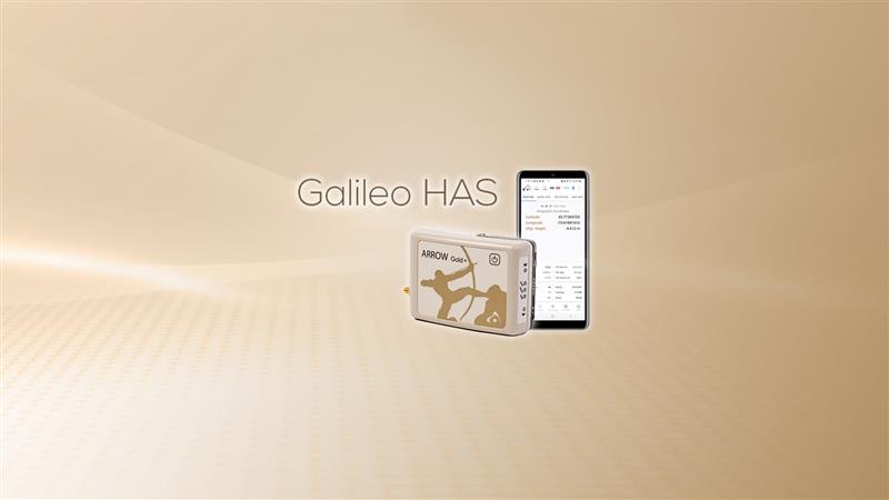
Eos Positioning Systems has released its Arrow Gold+ GNSS receiver, which supports the Galileo high-accuracy service (HAS). Arrow Gold+ enables users to achieve better than 20 cm accuracy with 95% confidence using Galileo HAS.
The Arrow Gold+ is one of the first high-accuracy GNSS receivers that supports Galileo HAS and is designed specifically for the geographic information systems market. Additional signal support for Arrow Gold+ includes: the concurrent use of the BeiDou B3 and GPS L5 signals as well as GLONASS, BeiDou, QZSS and IRNSS signals.
Galileo HAS is a differential correction service from the European Space Agency and European Union Agency for the Space Programme. The service became available on January 24, and it is the first global differential correction service to provide sub-meter accuracy to compatible GNSS receivers anywhere in the world.
For more information on the Arrow Gold+ click here.
The U.S. Federal Contractor Registration System for Award Management (SAM) makes private companies such as Eos Positioning Systems eligible for federal contracts.
Eos Positioning Systems, global manufacturer of the Arrow Series GNSS receivers, is now certified on the U.S. Federal Contractor Registration (USFCR) System for Award Management (SAM) for NDAA 2019, Section 889.
SAM registration is required to bid on, and get paid for, federal contracts.
According to USFCR.com, “[USFCR] is the largest and most trusted federal registration and certification service provider. We manage and maintain your SAM registration and guarantee its federal compliance.”
In August, Eos Positioning released two new Arrow Series GNSS receiver models: the Arrow Gold+ and Arrow 100+. Arrow receivers are the company’s flagship products.
Interested persons can find the Eos Positioning Systems SAM registration using the CAGE code L0P52 and the Unique Entity ID (DUNS) 202882361.
Eos Positioning Systems, the global manufacturer of Arrow Series GNSS receivers, has released Eos Bridge, which enables almost any instrument to become iOS Bluetooth compatible.
Photo: Eos Positioning
The Eos Bridge is a small, pocket-sized device that connects to instruments via Bluetooth Classic or serial port, and transmits data from them to any Apple iOS device, such as iPhone or iPad, Android device or Windows mobile device.
The Eos Bridge offers two connectivity methods to virtually hundreds of instruments:
First Method: Bluetooth Classic to Apple iOS Bluetooth
Instruments that are equipped with non-iOS Bluetooth are now able to connect to Apple iOS devices using the Eos Bridge, including laser rangefinders and utility-locating instruments.
Second Method: Serial port to iOS, Android and Windows devices
With the Eos Bridge, instruments whose only connectivity option is a serial port may now be connected to any iOS, Android or Windows device via Bluetooth. This includes any instrument or sensor with an RS-232 serial port, for example.
The Eos Bridge is lightweight, at approximately 150 grams (about 5.3 ounces). It can be worn clipped to a belt, stored in a pocket, or mounted to an instrument or sensor. The battery lasts 48 to 72 hours.
The Eos Bridge expands the potential pairings of legacy instruments and sensors by making them Bluetooth compatible with modern mobile devices and Arrow GNSS receivers. Two immediate applications for current Arrow GNSS users include Eos Laser Mapping for ArcGIS offset data-collection, and Eos Locate for ArcGIS for underground utility mapping. Both solutions are available on iOS.
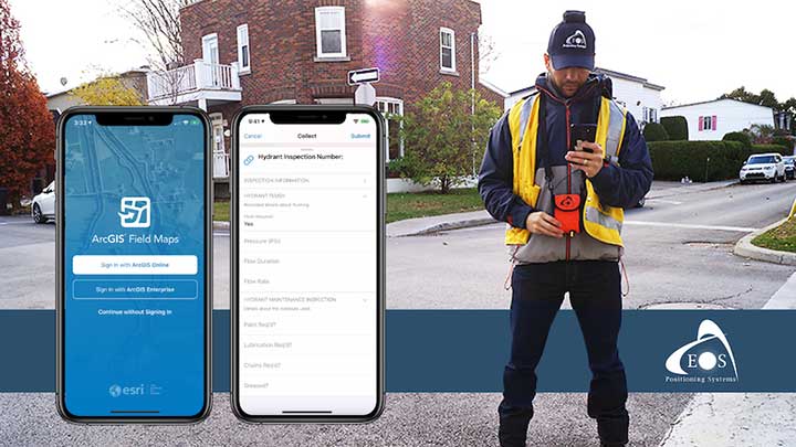
Eos will announce compatibility of its Arrow GNSS receivers with the inaugural ArcGIS Field Maps beta release, the expansion of Eos Locate underground mapping locator-device compatibility, as well more exciting updates for users of high-accuracy GPS with ArcGIS apps.
Eos Positioning Systems, manufacturer of the high-accuracy Arrow Series GNSS receivers for the GIS market, has announced several new releases ahead of the 2020 virtual Esri User Conference.
The announcements include the expansion of the availability of the Eos Locate
underground mapping solution, compatibility with the new ArcGIS Field Maps, the inaugural release of Eos Tools Pro for Windows, and a “special surprise” for virtual attendees of the 2020 Esri UC.
Image: Eos Positioning
Expansion of Eos Locate
Eos Locate is a high-accuracy, real-time underground mapping solution for Esri
ArcGIS apps users. It allows organizations to accurately map already-buried assets straight to ArcGIS Online via either ArcGIS Collector or ArcGIS Field Maps.
Eos has expanded Eos Locate compatibility with additional models from Vivax-Metrotech, Subsite and Radiodetection.
Compatibility with ArcGIS Field Maps beta
ArcGIS Field Maps is the newest Esri mobile application, which combines the functionality of several existing Esri mobile applications, such as ArcGIS Collector, ArcGIS Explorer, and ArcGIS Tracker.
The ArcGIS Field Maps beta release this month is already fully compatible with Arrow GNSS receivers (all models). This means organizations with Arrow GNSS receivers can immediately start taking advantage of survey-grade Arrow GNSS locations and metadata within ArcGIS Field Maps for data collection, markups, read-only routine field work (e.g., utility locates), GPS tracking, and more.
In addition, two Eos solutions previously exclusive only to Collector also already work with ArcGIS Field Maps. These include:
Eos Tools Pro is a free GNSS monitoring application for Arrow GNSS receivers. For the first time, this app is now available for Windows 10 users.
Eos Tools Pro allows fieldworkers to:
Connect to an RTK network or base station via NTRIP
Get elevations in orthometric heights via geoid model conversions in real time, in the field (directly into an Esri app)
Apply a simple X, Y, Z datum shift to the current location to match any local datum
Set a vast number of audible alarms
In addition, developers using Windows 10 will now be able to access the wide array of Arrow GNSS metadata while eliminating the task of parsing NMEA data.
Finally, Eos Tools Pro features a built-in duo of virtual Com Port and TCP/IP server to output streams of standard NMEA sentences. This enables multiple apps to have simultaneous access to the Arrow GNSS location and metadata.
Special surprise for eligible 2020 Esri UC attendees
In support of the inaugural virtual Esri UC, Eos is offering a one-time-only chance to win an Arrow 100 submeter GNSS receiver. To enter to win, eligible attendees must both
Complete a meeting with an authorized Eos representative during the 2020 Esri UC (July 13-16), which can be achieved by visiting the Eos virtual booth (V103), and
Fill out a special contest contact form made available by that representative.
Both the meeting and special contest contact form submission must be completed no later than July 16.
The following people are not eligible to win: Employees of Eos and Eos distributors, employees of Esri and Esri distributors, employees of other exhibiting/sponsoring companies, employees of other GPS manufacturers or vendors, registered media, and others whom we deem to have a similar affiliation.
Visit the Eos virtual booth (V103) to talk with sales, marketing, and technical support staff during the event expo hours.
A new Esri mobile app, ArcGIS Field Maps, will be released in its first beta in July, with the final version expected to be released in September.
According to Esri, Field Maps will combine the following capabilities into a single app:
Simple map viewing and markup
High-accuracy field data collection and inspection
Battery-optimized location tracking
Work planning and task management
Turn-by-turn navigation
Field Maps also will include a new web app, integrated with ArcGIS, that can be used to configure and deploy maps optimized for your mobile workforce needs, create and assign tasks to mobile workers, and create and share views of worker locations.
Arrow support included
The inaugural beta includes support for Arrow GNSS receivers’ high-accuracy locations, elevations and metadata, according to Eos Positioning.
ArcGIS Field Maps will provide the combined functionality of five Esri mobile apps: ArcGIS Collector, ArcGIS Explorer, ArcGIS Tracker, ArcGIS Workforce and ArcGIS Navigator.
In the first beta version, users will be able to perform markups, work with read-only maps, and work with MMPKs, including high-accuracy GPS locations and metadata from Arrow GNSS receivers.
Photo: Eos Positioning
Customers who have been wanting to take advantage of high-accuracy GNSS data in apps such as Explorer and Tracker will now be able to with the beta release. Customers who would like to have field crews able to access read-only maps with high-accuracy, for instance (such as during utility locates), this is now a possibility. In addition, crews can take advantage of high-accuracy GPS tracks while tracking.
ArcGIS Field Maps will also support the two formerly Collector-exclusive Eos solutions Eos Locate and Eos Laser Mapping.
Eos Locate. This high-accuracy underground mapping solution will be available in ArcGIS Field Maps right away in the first beta release. A single fieldworker will be able to perform real-time, high-accuracy mapping of underground assets using the same workflow he or she had previously used with Collector and Arrow GNSS.
Eos Laser Mapping. Similarly, laser offsets with Arrow GNSS receivers and LTI laser rangefinders will be available in the first beta of ArcGIS Field Maps. Learn more about laser offsets, including the three workflows for using them, here:
“We are incredibly excited for the new opportunities ArcGIS Field Maps brings to expand our partnership with Esri,” Eos CTO Jean-Yves Lauture said. “Now our joint customers will be able to use the Arrow GNSS receivers with Field Maps to access high-accuracy location when simply viewing and marking up maps and when logging location tracks.”
Eos Positioning told its customers, “We encourage all Eos customers currently using Collector, Tracker and/or Explorer to join the beta. Meanwhile, Collector, Tracker and Explorer are planned to continue working as usual, according to the roadmap Esri has outlined.”
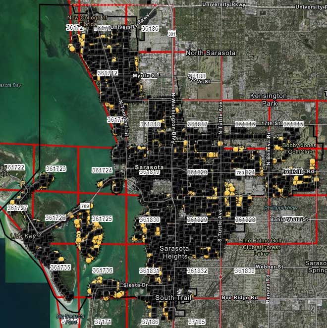
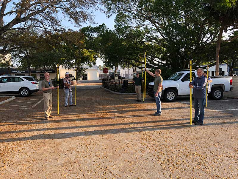
City officials in Sarasota, Florida, kept their staff actively working during COVID-19 social distancing mandates by training and tasking them with mapping utility data in the field.
The city’s plan to rebuild its GIS database had an estimated five-year timeline. GIS Coordinator William Rockwell suggested to city manager Tom Barwin that those unable to work from home be trained to collect the data. Rockwell worked with Sarasota IT Director Herminio Rodriguez to calculate the cost of acquiring enough GNSS receivers for the idle staff to use, and discovered a substantial cost savings.
Hands-on training took place in the Sarasota City Hall parking lot, with trainees practicing social distancing. (Photo: Eos Positioning)
“By implementing this project, we not only keep city staff productive, but we’ll also be collecting data that would otherwise cost hundreds of thousands of dollars if we outsourced the work,” Rockwell said.
Training from a Distance. Rockwell obtained affordable Arrow 100 GNSS receivers from an Eos Positioning distributor and hosted small-group training sessions in the city hall parking lot. Employees from a multitude of different departments were trained, such as a parking enforcement officer and a transportation planner.
All employees were carefully kept six feet apart. From a maintained distance, Rockwell explained the basic concept of data collection using high-accuracy Arrow 100 receivers with ArcGIS Collector.
The new team mapped 93% of street lights and road signs in one month. (Photo: Eos Positioning)
The employees took turns collecting sample data so Rockwell could address any initial concerns. He also gave each of them a printed map series, created in ArcGIS Pro, that showed the city divided into 28 grids. This allowed the team members to easily mark off where they collected data each day.
At the end of each day, the workers synced their data, collected by the Arrow 100s, to ArcGIS Online, which allowed Rockwell to monitor progress.
To date, 14 field workers have collected 93% of the city’s 6,000 street lights and 16,000 road signs. Although the 30-day project pilot has finished, the city plans to collect the remaining lights and signs, as well as the city’s 35,000 trees, later this year. High-accuracy GIS data collection has received encouraging feedback from management.
“I’m thrilled the city is supporting this initiative,” Rodriguez said. “To be able to take employees doing very, very different jobs and put them in the field — this wouldn’t have been possible in a normal environment. We are excited that everyone is chipping in.”
In the second part of our receiver feature, top receiver manufacturers discuss what’s on the horizon for GNSS receivers: recent and upcoming innovations, combating spoofing and jamming, fusing GNSS with other sensors, and the impact of increasing accuracy both for professional surveyors and consumers.
In January, we featured responses from NovAtel, Trimble, Unicore, Topcon, Hemisphere GNSS, CNC Navigation and Septentrio to questions about their recent and upcoming innovations in the design and manufacturing of GNSS receivers. We continue in this issue with responses to the same questions from Javad GNSS, Swift Navigation, Eos Positioning Systems, Tersus GNSS, TeleOrbit, Allystar Technology and NTLab.
All GNSS receiver manufacturers agree that spoofing and intentional and unintentional jamming are serious challenges. Their approaches to dealing with these challenges differ, however, as they rely on different combinations of technologies on both their receivers (such as monitoring cycle slips and using analog-to-digital converters, correlators and notch filters) and their antennas (such as using array antennas), as well as the new Galileo authentication service.
Photo: Tersus GNSS
Many receiver manufacturers now routinely use optical, inertial and other sensors — which continue to drop in price and increase in performance — to supplement GNSS signals where they are degraded or denied, especially in the automotive market.
Carrier phase positioning and correction services are increasingly improving the accuracy of survey stations and reducing their price. Meanwhile, submeter accuracy is spreading beyond surveying to other industries. Performance in challenging conditions also continues to improve, thanks largely to the increase in the number of GNSS constellations, available satellites and frequencies. (For a review of recent developments in antennas, see our companion article here.)
On the consumer side, the introduction of multi-frequency GNSS receiver chips, the increased use of correction services, and, in a few countries, the deployment of thousands of additional base stations will continue to increase the location accuracy of cell phones and other consumer devices, enabling new applications. However, in these devices size and cost limitations make antenna performance particularly challenging. (See Part 1 here.)
Javad GNSS
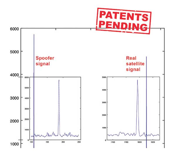
Jamming and Spoofing. “We protect you against jammers and spoofers like no one else can,” said Javad Ashjaee, founder and CEO of Javad GNSS. “We use multiple techniques to detect spoofers, the most important being the use of digital signal processing to detect more than one peak. First, with 864 channels and about 130,000 Quick Acquisition Channels in our Triumph chip, we have resources to assign more than one channel to each satellite to find all signals that are transmitted with that GNSS PRN code. If we detect more than one reasonable and consistent correlation peak for any PRN code, we know that we are being spoofed and can then identify the spoofer signals and ignore the wrong peak.”
An example of two peaks. (Chart: Javad GNSS)
Ashjaee described additional techniques:
The J-Shield filter blocks out-of-band interference.
Sixteen 255th-order FIR anti-jam digital filters protect against static in-band interference, and 16 adaptive 80th-order digital filters protect against dynamic interference.
Javad products measure the level of interference as a percentage of in-band noise above normal.
The Triumph chip has a powerful spectrum analyzer. Each spectrum shows the power and the shape of the interfering signals and jammers. This is more powerful and more efficient than using a commercial spectrum analyzer to evaluate the environment.
The chip also keeps a record of Automatic Gain Control, which is another indicator of external signals. A change in AGC can indicate interference.
Deviation of SNR from the expected value is another important indicator of interference.
“Usually there are over 100 signals available at any given time, and we need only four good signals to compute position. It is extremely unlikely that we can be spoofed without our knowledge.” Ashjaee concluded. “We will immediately recognize and take corrective actions.”
Jamming and spoofing protection is available on all Javad GNSS receivers and OEM boards. Read more about Javad GNSS’s jamming and spoofing protection in the December 2019 issue.
Sensor Fusion. “To support users in environments where GNSS RTK solutions are difficult or impossible to obtain,” Ashjaee said, “Javad GNSS has invented the J-Mate, which is a remotely controlled robotic EDM device and digital camera. GNSS RTK and optical can be seamlessly integrated using the J-Mate as the seventh RTK engine. Just set up a Triumph-3 on top of a J-Mate and a Triumph LS on top of a zebra rod, making the former pair the RTK base station and the latter pair the RTK rover.” Read more about Javad GNSS’s RTK and Optical United solution in the November 2019 issue.
Swift Navigation
Jamming and Spoofing. “Receivers have become more robust to intentional jamming by mimicking the jammers’ behavior to cancel it,” said Alex Pun, staff product manager for Swift. “Nevertheless, advanced jamming and spoofing mitigation often imply array antennas. A real evolution lies in considering these threats only in terms of the availability of the GNSS sensor, now part of a complete multi-sensor positioning engine such as Starling.”
Sensor Fusion. IMUs, visual sensors and GNSS will aid each other in different types of environments and scenarios, explained Pun. “Sensors are becoming more affordable, and their performance increases with each new generation. Sensor fusion will be the glue that will bind them to provide a precise positioning solution.”
Surveying. The combined use of carrier-phase positioning and correction services, such as Swift’s Skylark, will greatly improve accuracy and reduce the cost of survey stations, because they make their accuracy less dependent on the intrinsic performance of the receiver and the antenna, Pun said. “A global service eliminates the need for an individual base station.”
Consumer Devices. “The introduction of dual-frequency GNSS receivers from chip manufacturers will help improve positioning in cell phones and other consumer devices,” Pun said. “These chips, coupled with a widely available correction service such as Skylark, will greatly improve their performance accuracy to sub-meter levels.”
Other Challenges. Performance stability of the antenna and its characterization will become the main challenge to exploiting the new GNSS ASICs (application-specific integrated circuits) and correction services at their highest level of performance, Pun said. “A positioning engine can exploit this information to accelerate the convergence to the high-accuracy solution, and then improve its availability.”
Eos Positioning Systems
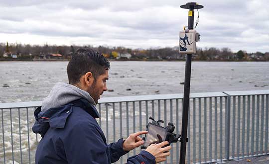
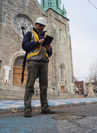
A surveyor uses the Arrow Gold receiver to map assets in Terrebonne, Quebec, Canada. (Photo: Eos Positioning)
“The past three years have seen considerable innovations and trends in the GNSS industry,” said Jean-Yves Lauture, CTO of Eos Positioning. “Receivers are becoming increasingly affordable and the adoption of higher-accuracy (submeter, centimeter) positioning by other industries, outside of conventional surveying, is growing. Considering the now four usable GNSS constellations and the aggressive launches of Galileo and BeiDou satellites, the number of available satellites and the list of frequencies they use has considerably increased.
“Although accuracy itself is not really improving, performance is — particularly in tougher conditions. It’s not uncommon for customers to use 30 to 35 satellites out of more than 40 in view using an Arrow Series GNSS receiver. The numbers are even higher in the Pacific regions, thanks to geostationary BeiDou satellites. This is, by far, more than double the number of satellites available with just GPS and GLONASS.”
Consumer Devices. “It will be challenging for smartphones and consumer devices to achieve survey-grade accuracy in the next few years. They face certain limitations. For instance, there is a cost and physical size associated with using a high-end GNSS antenna with a minimum of ground plane to achieve these levels of accuracy.
The Arrow Gold RTK GNSS receiver. (Photo: Eos Positioning)
“Also, it is unlikely that the manufacturers of consumer devices will invest in developing the advanced algorithms needed for a high level of constant accuracy and performance. In order to fit into a smartphone, consumer-grade GNSS chipset manufacturers must drop the use of many available signals and frequencies to keep both size and power consumption to a minimum.”
Allystar Technology
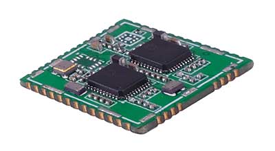
Photo: Allystar
Jamming and Spoofing. The GNSS chip in Allystar’s TAU1301 module supports eight adaptive notch filters to reduce the effects of GNSS jamming, explained Shi-Xian Yang, senior principal engineer in the company’s Baseband Algorithm Department. “It significantly improves the performance of GNSS tracking measurements, even in the presence of strong and fast-varying jamming signals.”
Sensor Fusion. The TAU1310 integrates a six-axis micro-electromechanical system (MEMS) gyro, which makes its affordable for the mass market, Yang said.
The Lenovo Z6. (Photo: Lenovo)
Consumer Devices. In its Z6 smartphone, Lenovo has taken advantage of the great improvement in multipath mitigation provided by the L5 signal’s higher chip rate and the output of high quality raw data via the TAU1302’s HD8040 GNSS chipset to improve the accuracy experience in the consumer market, Yang explained. Additionally, he pointed out, cell phones and other consumer devices now enable developers to access the raw sensor data from such sensors as accelerometers and barometers to input into their fusion algorithms.
Other Challenges. In the future, the TAU1310 could also support the L6 signal for PPP-RTK application.
NTLab
NTLab anti-jamming GNSS receiver. (Photo: NTLab)
Jamming and Spoofing. The problem of jamming and spoofing worries customers, according to Konstantin Yuriev, lead GNSS engineer at NTLab. The combination of anti-jam and anti-spoofing is in greater demand because the anti-jam feature alone is becoming insufficient. Yuriev cited the European Union’s new requirements for the European Railway Traffic Management System (ERTMS), which makes anti-spoofing mandatory.
The key issue today is “the solution to the problem of reducing the size and cost of anti-jam receivers, so that they become available to consumers on the civilian market. The key technology for this will be increasing the degree of integration of the component base, first creating a chipset for solving anti-jamming and anti-spoofing tasks, and then moving on to a single-chip solution. We have created a chipset and are ready to start work on the further integration into a single chip.”
Sensor Fusion. The traditional task of integrating data from a GPS antenna and a MEMS sensor has been solved, Yuriev said, with many such solutions on the market. One task is to track the antenna’s tilt. “The antenna, GNSS receiver, and MEMS sensors should be located very closely to each other — if possible, on a single small board,” Yuriev said. “Here, again, the solution is to increase the degree of integration, up to placing the baseband processor on the same chip with the digital CMOS circuitry of the MEMS sensor.” Another application of MEMS is serving as the core of an inertial navigation system (INS), providing an auxiliary subsystem for detecting the presence of spoofing. “This is more of an algorithmic task,” Yuriev said, “because traditional coupling using recursive filters is not enough. It is necessary to ensure the independence of the INS subsystem from the GNSS solution, or their intelligent mutual cross-control.”
Surveying. A major part of the cost of a survey-grade device, Yuriev pointed out, is for additional services, know-how, and other added values. There is market demand for a business model in which device price could go down while maintaining the main values for the customer. “This could be achieved if end-users tightly cooperate with hardware manufacturers, skipping third-party integrators. Alternatively, multiple third parties could compete, keeping the cost of the software low. One of the technical solutions for this is to provide software application programming interfaces (APIs) that will allow multiple third parties to offer application-level software for the same hardware. We call it the ‘open platform’ approach. One of our products implements this strategy.”
Other Challenges. Despite some skeptics, Yuriev argued, new GNSS systems have been successful. “A good example is IRNSS (NavIC), with India’s population of 1.3 billion forming a potential market. Moreover, according to our studies, good coverage is provided not only in India’s territory. We are working on creating an economically affordable solution with support for the NavIC S-band. A new chip-scale packaged RFIC (radio-frequency integrated circuit) should minimize the size, consumption, and price of NavIC-oriented modules, while maintaining all the advantages of the S-band signal in areas close to the equator. This is our solution to the problem.”
TeleOrbit
GOOSE platform. (Photo: Fraunhofer IIS)
GNSS Receiver Development Platform. The company’s GOOSE platform is a field-programmable gate array (FPGA)-based GNSS receiver, developed by Fraunhofer IIS, making it flexible in processing new or proprietary signals, according to Katrin Dietmayer, software development engineer at Fraunhofer IIS. “It comprises 60 hardware channels in real time and provides an open software interface for customer applications,” she explained.
Jamming and Spoofing. “It grants deep access to the hardware interface, down to, for example, the correlation values. Additionally, anti-jamming functions (such as notch-filter or pulse-blanker) can be added and anti-spoofing algorithms are already implemented. Thanks to the open architecture, our customers can also implement these or other algorithms.”
Sensor Fusion. Vector tracking in real time is already implemented on code base. Deep coupling with INS/IMU multi-sensor fusion — for example, with an odometer, ultra wideband or 5G — are possible and under development, Dietmayer said.
Surveying.TeleOrbit provides GNSS-RTK using RTKLIB. “The implemented Open GNSS Receiver Protocol (OGRP) is fully documented with a parsing tool using CONVBIN from RTKLIB as RINEX converter,” Dietmayer explained.
Consumer Devices. GOOSE is also used as the reference receiver in the ESA project Receiver Technologies for Future Mass Market (RT4FMM) devices. The project validates state-of-the-art dual-frequency mass-market receivers based on Broadcom BCM47755 and u-blox F9 and compares their performance against GOOSE E5AltBOC processing.
Other Challenges. GOOSE already processes the new Galileo OS-NMA (Open Service – Navigation Messages Authentication), while implementing the new Galileo High Accuracy Service (HAS) is on the roadmap. “The combination of these new features will result in a robust and reliable high-accuracy position,” Dietmayer said. “For system testing, the intermediate frequency signals can be recorded, processed and replayed with the platform.”
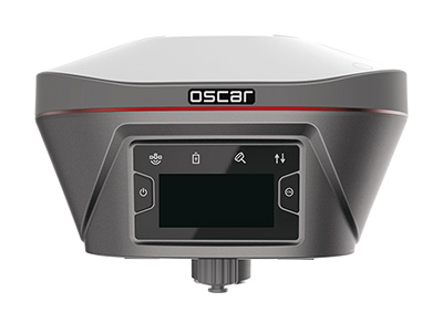
Tersus GNSS
The Oscar. (Photo: Tersus GNSS)
Jamming and Spoofing. Xiaohua Wen, founder and CEO, said his company has done much research and testing on jamming and spoofing. “We already implemented a high dynamic analog-to-digital converter to overcome jamming. To mitigate spoofing, we think that internet of things (IoT) devices can leverage cloud services. Alternatively, the new Galileo authentication service may serve the same function.”
Sensor Fusion.Tersus GNSS makes an INS product, and its Oscar receiver contains an inertial measurement unit (IMU). “The sensor fusion hub is a very hot topic in the automobile industry,” Wen said. “We are quickly adapting our Oscar and INS product line for the creation of high definition maps and for indoor navigation. We think it’s still the major pain point for a crowded country such as China.”
Surveying. As has been the case in many other industries, Wen said, the widespread adoption of GNSS technology and the increase in the number of players in the field has led to a drop in prices. “Tersus’ David and Oscar models are low cost but still perform well compared with Tier 1 players for professional survey machines using our own OEM GNSS board,” he said.
Consumer Devices. The fact that a few vendors are providing dual-frequency chipsets in smartphones opens the door for consumer-grade sub-decimeter applications, Wen said. “But we think the antenna could be a big challenge for the small devices.”
Other Challenges. “Mobile carriers are building thousands of base stations,” Wen said. “For example, Softbank in Japan completed 3,300 stations this year. China Mobile just issued a bid for a phase one project for 4,400 stations. We think mobile phone innovations for the new high-accuracy application may have some impacts in the coming years. We have been actively looking at some new GIS (geographic information systems) applications based on our in-house Nuwa platform.”
Eos Locate for Collector combines three core technologies: Eos Arrow GNSS receivers, Esri Collector, and the Vivax-Metrotech vLoc Series of locator devices.
With Eos Locate for Collector, one field worker can collect both GNSS locations and locator data (such as depth below cover) for any buried asset including water, sewer, electric, cable, gas, fiber infrastructure and more. They can do so quickly, accurately and without the need for any additional field or office support.
“We are giving our Arrow GNSS customers a solution today that allows them to combine both locator data and high-accuracy locations in web maps,” Eos CTO Jean-Yves Lauture said. “This greatly simplifies their workflow by allowing one person to do underground locates and GIS mapping simultaneously.”
“This is a big step forward for utility organizations who need to gain better visibility of their infrastructure,” said Doug Morgenthaler, Esri program manager. “With today’s technology, utilities can already see where new assets are being put in the ground. The challenge historically has been figuring out where existing assets are.”
Eos Locate for Collector not only streamlines underground-asset mapping, but also improves office production times. It eliminates the need to manually combine datasets from the locator and GPS devices within ArcGIS.
“Seeing all that information from utility locators and GPS receivers packaged directly into a GIS application is exceptional,” Vivax-Metrotech Eastern Regional Sales Manager Kelvin Cherrington said. “This solution will help utilities create maps of their underground assets with a much more modern and efficient methodology.”
Indiana American Water Early Adoption
Earlier this year, Indiana American Water approached Eos to seek a solution that consolidated their utility-locate workflow with their Arrow and Collector field work.
“We had the manpower to put paint down,” said Todd Chapman, Indiana American Water Senior GIS Analyst. “But we would need to hire another person to map the locations with our Arrow Gold GNSS receivers.”
Chapman estimates Eos Locate for Collector will cut their field time in half as well as enable the creation of extremely accurate buried-infrastructure maps in ArcGIS.
“Previously, we were seeing that our old water mains could be off by up to 20 feet,” Chapman said. “With the new Eos Locate for Collector, we’re seeing that it’s accurate to under an inch.”
The initial release of Eos Locate for Collector runs on Apple’s iOS iPhones and iPads and supports the vLoc Series from Vivax Metrotech. Future releases of Eos Locate for Collector will support additional locator models including the vScan series.
With accurate digital twins of their buried infrastructure, utilities across sectors can expect improvements to safety, damage prevention, field efficiency and regulatory compliance.
“Not only does this mean quicker responses to 811 tickets and fewer liabilities during field digs,” Lauture said. “But it also constitutes a major step forward toward the highly efficient future of 3D asset management and viable augmented-reality workflows.”
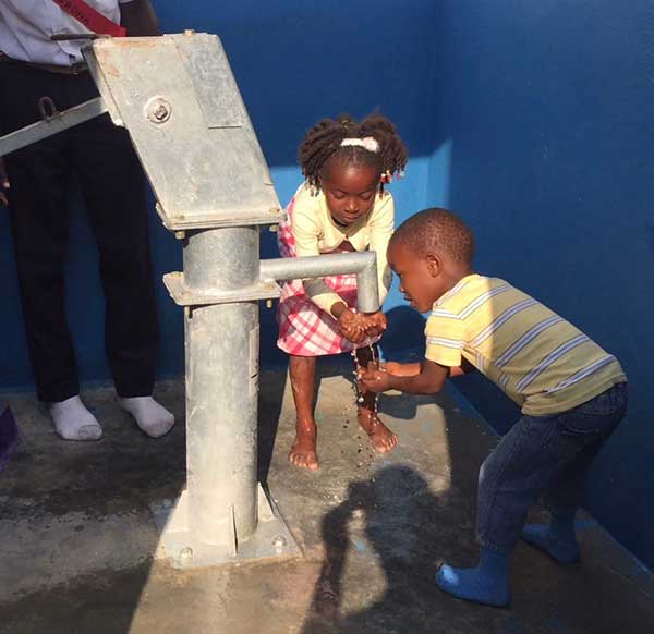
Haiti Outreach is on a mission to bring clean drinking water to 100% of Haitian communes. The non-profit organization is using EOS Positioning Systems’ Arrow Gold GNSS receivers to transform how water access is addressed.
In the Western Hemisphere’s poorest nation, poverty and corruption have stifled development. But Haiti Outreach is using geospatial software and donations to ensure every household has access to clean drinking water. Their technology includes mWater, EPANET, and Arrow Gold with Atlas.
In this video, you’ll hear from Haiti Outreach Director Neil Van Dine and Eos Positioning Systems CTO Jean-Yves Lauture on the importance of combining spatial strategy with a human element.
In Haiti 95% of unprotected springs are contaminated with E. coli, with 48% of water infrastructure across 50 communes delivering water contaminated with E.coli (Haiti Outreach 2018 study). For 22 years, a nonprofit called Haiti Outreach has tried to increase access to clean water by drilling wells for Haitian communities (called communes).
Haiti Outreach tried drilling new wells, but that didn’t solve the problem. The answer is education. “It’s all about creating a transformation in the way we think,” Van Dine said. “Water is free, but somebody has to maintain the well, replace parts, and so on in the long term. All those things cost money.”
Achieving a 50-cents per household fee for maintenance, Haiti Outreach still needed to know if everyone in Haiti had access to clean drinking water. The organization needed to know the location of every household in relation to water sources. They also needed to know if these water sources were clean, contaminated, functioning or broken.
Outreach decided to use the open-source hydraulic-modeling software EPANET, from the U.S. government, and hired mWater to build an integration. By running population-density overlays in mWater, it was possible to identify where there were enough households (25) to create a revenue stream to support a new well. With 100 households, the revenue could support a new in-home water-distribution network.
Photo: Haiti Outreach
They also used Android phones and Arrow Gold with Atlas. By pairing the Arrow Gold with Atlas, they were able to get decimeter accuracy. (Atlas is a satellite-based differential correction service.)
“The Android phones got about 10 meters of accuracy on their own,” Haiti Outreach fieldwork coordinator Micki Johns said. “But the Arrow Gold with Atlas got us within that decimeter range.”
Data collected in mWater went into EPANET to simulate water pressure and flow.
Haiti Outreach used the findings to develop a community action plan (CAP). The CAP prioritized cleaning contaminated sources and ranked contaminated sources by the highest number of people who would benefit from a decontamination.
Orthometric height support (survey-grade elevations) enables Arrow GNSS receivers to collect high-accuracy, survey-grade vertical data with any data-collection software.
Eos Positioning Systems Inc. has added support for GEOID height models within its Arrow Series GNSS receivers. Eos manufactures high-accuracy GNSS receivers for any app running on iOS/Android/Windows devices and using the Eos Arrow Series.
“You can use Arrow Series receivers with any data-collection software in the world, and benefit from accurate orthometric heights,” Eos CTO Jean-Yves Lauture said. “Our Arrow receivers will output accurate GNSS elevations no matter which data-collection software you use to capture it.”
Image: Eos Positioning
With support for GEOID models, Arrow receivers automatically output survey-grade elevations to all iOS and Android data collection software. Support will also soon be available for Windows devices.
The Arrow receivers now support the entire United States to provide survey-grade elevation in NAVD88 orthometric heights through the GEOID12B (US) model. The Arrow receivers also support the Canadian CGG2013a and HTv2.0 GEOID models for the CGVD2013 and CGVD28 vertical datums, respectively. Additional GEOID models for other countries are planned.
“Eos is intensely focused on supporting high-accuracy GIS, engineering, surveying and construction users by supporting the latest GEOID elevation models within our GNSS monitoring software,” Lauture said. “Our roadmap remains focused on high-accuracy BYOD users by supporting all iOS, Android and Windows users with this capability.”
The problem is that typical Bluetooth GNSS receivers usually provide inaccurate, built-in elevation models. This inaccuracy is reflected in the Mean Sea Level elevation output by those receivers. By outputting orthometric height, the Arrow now solves this problem and turns any smartphone or tablet into a 3D, survey-grade accurate data collection device, the company said.
Eos has designed this new feature so that users will easily be able to update to new GEOID models as they become available.
Field technicians in pipeline, construction, engineering, architecture, water and any other industry are finally able to enjoy GNSS location with survey-grade vertical accuracy on their iOS and Android devices, with the data-collection app of their choice and their Eos Arrow receivers.
WaterOne found itself stuck in the past. The independent public utility knew that its workflow for collecting geospatial data was broken.
WaterOne serves a 272-square-mile area on the Kansas side of the Kansas City, Missouri, metropolitan area, which has a population of 420,000, 145,000 metered accounts and 2,685 miles of water pipes. The survey/geospatial staff consisted of three analysts, two editors, one programmer and one GPS collector. By 2016, less than 40 percent of the water features had been captured with GPS.
The staff was using legacy GNSS handhelds — operators had to return to the office every night and physically download their data.
Besides being time-consuming, the operators would become frustrated by the antiquated system. Sometimes the handhelds wouldn’t sync to the computer, or files for download would be hard to find. Also, the GNSS handhelds had a tiny screen, making it difficult for operators to see background data in the field. The handhelds’ limited computing power meant the entire water system couldn’t be loaded onto it.
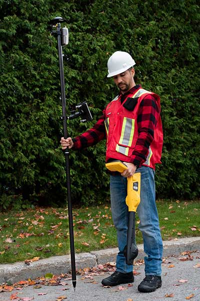
WaterOne turned to a new workflow using Panasonic ToughPad tablet computers and Eos Positioning Systems’ Arrow 200 RTK GNSS receivers mounted on a range pole (see photo).
The Arrow 200 receiver connects to the Panasonic ToughPad via wireless Bluetooth link. The ToughPad has a Verizon SIM card for internet connectivity, used for two purposes:
Connecting to the Missouri Department of Transportation RTK network to receive RTK corrections for centimeter accuracy;
Connecting to the WaterOne ArcGIS server in real time from the field.
Whenever the field tech collects data, the data syncs up with ArcGIS server. This eliminates the task of having to physically download the data at the end of the day.
The new workflow also provides near real-time updates to WaterOne’s geospatial information system. This means that if five techs are in the field collecting data, they can each see the map updated in near real time.
The ToughPad tablets have a large, sunlight-readable 10-inch display. The large displays combined with the new data-collection software allows the field techs to view the entire GIS water system on the tablets. The field tech can now “see” all of the water system assets — pipes, valves, fittings, hydrants — around them. This significantly improves productivity over the legacy GNSS handhelds.
Street maps and aerial photos were loaded on the ToughPad to give the field techs a choice of background data to view.
The result? Compared to the 1,767 GPS points collected in 2016, the WaterOne team has collected 5,770 just in the first four months of 2017.
TerraGo and Eos Positioning Systems have entered a collaboration to combine the TerraGo Edge mobile GPS data-collection platform with the Eos Arrow line of sub-meter and centimeter accuracy receivers. The combination delivers a modern, cloud-based, real-time data collection capability, according to a TerraGo press release.
While the working environments and the projects are very different, customers in for water utilities, energy, survey and engineering are using TerraGo Edge and Eos Arrow receivers to replace traditional GPS handhelds for cost-savings and improved productivity.
Enmapp, a pipeline inspection company based in Canada, was able to cut hardware costs by 85 percent while capturing sub-meter data in real-time, eliminating all the costs of post-processing handheld data.
Summit Engineering, a Colorado-based engineering and land surveying firm, was able to reduce hardware costs by over 50 percent and improve productivity by more than 30 percent while surveying power lines in Minnesota for one of the country’s largest energy companies. Similar performance improvements and cost reductions are reported by joint customers in water utilities, forestry, engineering, agriculture and environmental operations, TerraGo said.
“When we talk about Eos Arrow, we’re not simply pairing their receivers via Bluetooth, there are millions of apps that do that without any meaningful integration,” said Dave Basil, VP of products and services at TerraGo. “We interoperate with their receivers at the software level to ensure our customers get the full real-time GPS data set so they can monitor, alert and capture data that meets the highest accuracy and quality standards. For customers, it’s as simple as Bluetooth pairing, but we’ve done the work to turn their phone or tablet into a survey-grade receiver.”
“TerraGo and Eos Positioning are strategic technology partners,” said Jean-Yves Lauture, chief technology officer of Eos Positioning Systems. “This means that our collaboration goes beyond simple marketing and includes sharing core technology for the benefit of our customers. For example, we have been able to share Eos software components, which TerraGo has built into the Edge app. This integration provides the full fidelity monitor and lossless capture of NMEA data from the Eos receivers, including the Arrow 200.”